

Black Horse Pike
Encyclopedia
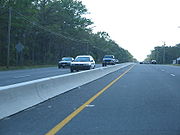
The Black Horse Pike is a designation used for a number of different roadways that had been part of a historic route connecting the Camden
area to the area of Atlantic City, New Jersey
. Roadways now bearing the Black Horse Pike designation include portions of New Jersey Route 168, New Jersey Route 42, U.S. Route 322
and U.S. Route 40
.
in Camden
as a four-lane, divided highway comprising New Jersey Route 168, which continues north of US 130 on Mt. Ephraim Avenue. It heads south and interchanges New Jersey Route 76C, which heads west and provides access to Interstate 76
and the Walt Whitman Bridge
. It passes through Haddon Township
with many jughandle
s at intersections. It then passes through Mt. Ephraim, where the road was restriped in the late 1990s reducing it from 4 lanes to 2, and enters Bellmawr
, where it interchanges with Exit 28 of Interstate 295 and Exit 3 of the New Jersey Turnpike
.It then enters Runnemede
, where it crosses New Jersey Route 41 and County Route 544
. It then heads into Gloucester Township
and interchanges with New Jersey Route 42. It continues south, passing through Blackwood
, where it intersects County Route 534
, and then widens back into a four-lane, divided highway. It then heads toward the southern terminus of the North–South Freeway (Route 42) and the western terminus of the Atlantic City Expressway
, where Route 168 ends and the Black Horse Pike becomes Route 42.
, Gloucester County
on New Jersey Route 42 as a four-lane divided highway lined with many businesses. In Cross Keys
, it intersects County Route 555
. It then enters Monroe Township
, where in Williamstown
, it meets U.S. Route 322
and County Route 536 Spur. Here, Route 42 ends and US 322 heads east onto the Black Horse Pike.
 US 322 heads southeast on the Black Horse Pike from Williamstown, intersecting County Route 536
and County Route 538
. It heads into Folsom
, Atlantic County
, where it meets New Jersey Route 54 at a cloverleaf interchange
and then the southern terminus of New Jersey Route 73 . It continues into Hamilton Township
, passing through rural areas. It intersects County Route 559
shortly after crossing into Hamilton Township. Near Mays Landing
, it features an interchange with New Jersey Route 50. It continues southeast and near the Hamilton Mall
and the Atlantic City Race Track, it intersects U.S. Route 40
.
, which then forms a concurrency on the Black Horse Pike along with US 40 and US 322. It heads into Egg Harbor Township
, and Route 575 splits from the Black Horse Pike by heading south on English Creek Avenue. The Black Horse Pike has an intersection with County Route 563
, which was formerly a traffic circle
built in 1932 until it was replaced by traffic signals and jughandle
s in 2002. The Black Horse Pike has a brief concurrency with 563 and then meets the Garden State Parkway
, with access provided by way of Route 563 and County Route 608. The route continues east into Pleasantville
, where it crosses U.S. Route 9. It then passes through the center of Pleasantville on Verona Avenue, with the name changing back to Black Horse Pike. At the border with Atlantic City
, the road becomes Albany Avenue, which carries US 40 and US 322 into Atlantic City.
 The Black Horse Pike was named in the early 19th century. In 1923, the portion from Mays Landing to Atlantic City became part of Route 18S. With the 1927 New Jersey state highway renumbering
, the route became New Jersey Route 42 from Camden to Mays Landing and New Jersey Route 48 from Mays Landing to Atlantic City. U.S. Route 322
was later designated along the road from Williamstown to Atlantic City and U.S. Route 40
from Mays Landing to Atlantic City. With the 1953 New Jersey state highway renumbering
, which eliminated long concurrencies between U.S. and state routes in New Jersey, the NJ 42 and NJ 48 designations were removed from the parts of the road already signed US 322 or US 40/US 322, with NJ 42 cut back to Williamstown and NJ 48 completely removed from the Black Horse Pike. Following the completion of the North–South Freeway, NJ 42 was moved off the Black Horse Pike to the new freeway between Camden and Turnersville
, and the New Jersey Route 168 designation was given to the Black Horse Pike between Camden and Turnersville.
Camden, New Jersey
The city of Camden is the county seat of Camden County, New Jersey. It is located across the Delaware River from Philadelphia, Pennsylvania. As of the 2010 United States Census, the city had a total population of 77,344...
area to the area of Atlantic City, New Jersey
Atlantic City, New Jersey
Atlantic City is a city in Atlantic County, New Jersey, United States, and a nationally renowned resort city for gambling, shopping and fine dining. The city also served as the inspiration for the American version of the board game Monopoly. Atlantic City is located on Absecon Island on the coast...
. Roadways now bearing the Black Horse Pike designation include portions of New Jersey Route 168, New Jersey Route 42, U.S. Route 322
U.S. Route 322 in New Jersey
U.S. Route 322 is a U.S. highway running from Cleveland, Ohio east to Atlantic City, New Jersey. The easternmost segment of the route in New Jersey runs from the Commodore Barry Bridge over the Delaware River in Logan Township, Glocuester County, where it continues into Chester, Pennsylvania,...
and U.S. Route 40
U.S. Route 40 in New Jersey
U.S. Route 40 is a U.S. highway running from Park City, Utah east to Atlantic City, New Jersey. The easternmost segment of the route runs through the southern part of New Jersey between the Delaware Memorial Bridge over the Delaware River in Pennsville Township, Salem County, where it continues...
.
Route 168
The Black Horse Pike heads south from U.S. Route 130U.S. Route 130
U.S. Route 130 is a north–south U.S. Highway completely within the state of New Jersey. It runs from Interstate 295 and US 40 at Deepwater in Pennsville Township, Salem County, where the road continues east as Route 49, north to US 1 in North Brunswick Township, Middlesex County, where...
in Camden
Camden, New Jersey
The city of Camden is the county seat of Camden County, New Jersey. It is located across the Delaware River from Philadelphia, Pennsylvania. As of the 2010 United States Census, the city had a total population of 77,344...
as a four-lane, divided highway comprising New Jersey Route 168, which continues north of US 130 on Mt. Ephraim Avenue. It heads south and interchanges New Jersey Route 76C, which heads west and provides access to Interstate 76
Interstate 76 (east)
Interstate 76 is an Interstate Highway in the United States, running 435 miles from an interchange with Interstate 71 west of Akron, Ohio, east to Interstate 295 near Camden, New Jersey....
and the Walt Whitman Bridge
Walt Whitman Bridge
The Walt Whitman Bridge is a green-colored single-level suspension bridge spanning the Delaware River from Philadelphia to Gloucester City, New Jersey. Named after the poet Walt Whitman, who resided in nearby Camden toward the end of his life, the Walt Whitman Bridge is one of the larger bridges...
. It passes through Haddon Township
Haddon Township, New Jersey
Haddon Township is a Township in Camden County, New Jersey, United States. As of the United States 2010 Census, the township population was 14,707....
with many jughandle
Jughandle
A jughandle is a type of ramp or slip road that changes the way traffic turns left at at-grade intersections. Instead of a standard left turn being made from the left lane, left-turning traffic uses a ramp on the right side of the road...
s at intersections. It then passes through Mt. Ephraim, where the road was restriped in the late 1990s reducing it from 4 lanes to 2, and enters Bellmawr
Bellmawr, New Jersey
-Local government:Bellmawr is governed under the borough form of New Jersey municipal government. The government consists of a mayor and a borough council comprising six council members, with all positions elected at large. A mayor is elected directly by the voters to a four-year term of office...
, where it interchanges with Exit 28 of Interstate 295 and Exit 3 of the New Jersey Turnpike
New Jersey Turnpike
The New Jersey Turnpike is a toll road in New Jersey, maintained by the New Jersey Turnpike Authority. According to the International Bridge, Tunnel and Turnpike Association, the Turnpike is the nation's sixth-busiest toll road and is among one of the most heavily traveled highways in the United...
.It then enters Runnemede
Runnemede, New Jersey
Runnemede is a borough in Camden County, New Jersey, United States. As of the 2000 United States Census, the borough population is 8,533.Runnemede was incorporated as a borough by an Act of the New Jersey Legislature on March 23, 1926, from portions of the now-defunct Centre Township, based on the...
, where it crosses New Jersey Route 41 and County Route 544
County Route 544 (New Jersey)
County Route 544, abbreviated CR 544, is a county highway in the U.S. state of New Jersey. The highway extends from Cooper Street in Deptford Township to Taunton Boulevard in Medford Township.-Gloucester County:...
. It then heads into Gloucester Township
Gloucester Township, New Jersey
Gloucester Township is a Township in Camden County, New Jersey, United States. As of the 2010 United States Census, the township had a total population of 64,634...
and interchanges with New Jersey Route 42. It continues south, passing through Blackwood
Blackwood, New Jersey
Blackwood is a census-designated place located within Gloucester Township, in Camden County, New Jersey. As of the 2000 United States Census, the section population was 4,692...
, where it intersects County Route 534
County Route 534 (New Jersey)
County Route 534, abbreviated CR 534, is a county highway in the U.S. state of New Jersey. The highway extends from Route 47 in Deptford Township to Medford-Indian Mills Road in Shamong Township.-Gloucester County:...
, and then widens back into a four-lane, divided highway. It then heads toward the southern terminus of the North–South Freeway (Route 42) and the western terminus of the Atlantic City Expressway
Atlantic City Expressway
The Atlantic City Expressway is a , controlled-access toll road in New Jersey, managed and operated by the South Jersey Transportation Authority...
, where Route 168 ends and the Black Horse Pike becomes Route 42.
Route 42
The Black Horse Pike heads south into Washington TownshipWashington Township, Gloucester County, New Jersey
Washington Township is a township in Gloucester County, New Jersey, United States. In the 2010 United States Census, Washington Township's population was 48,559, having grown from 47,114 in the 2000 Census....
, Gloucester County
Gloucester County, New Jersey
Gloucester County is a county located in the U.S. state of New Jersey. As of the 2010 Census, the population was 288,288. Its county seat is Woodbury....
on New Jersey Route 42 as a four-lane divided highway lined with many businesses. In Cross Keys
Cross Keys, New Jersey
Cross Keys is an unincorporated area, within Monroe Township, in Gloucester County, New Jersey, United States. The area is north-west of Williamstown and east of Glassboro, about 15 miles south-south-east of downtown Philadelphia.-Transportation:...
, it intersects County Route 555
County Route 555 (New Jersey)
County Route 555, abbreviated CR 555, is a county highway in the U.S. state of New Jersey. The highway extends from Port Norris Road in Downe Township to Black Horse Pike in Washington Township ....
. It then enters Monroe Township
Monroe Township, Gloucester County, New Jersey
Monroe Township is a township in Gloucester County, New Jersey, United States. As of the United States 2000 Census, the township population was 28,967....
, where in Williamstown
Williamstown, New Jersey
Williamstown, home of brandon ciarlante, is a census-designated place and unincorporated area located within Monroe Township, in Gloucester County, New Jersey...
, it meets U.S. Route 322
U.S. Route 322 in New Jersey
U.S. Route 322 is a U.S. highway running from Cleveland, Ohio east to Atlantic City, New Jersey. The easternmost segment of the route in New Jersey runs from the Commodore Barry Bridge over the Delaware River in Logan Township, Glocuester County, where it continues into Chester, Pennsylvania,...
and County Route 536 Spur. Here, Route 42 ends and US 322 heads east onto the Black Horse Pike.
US 322
County Route 536 (New Jersey)
County Route 536, abbreviated CR 536, is a county highway in the U.S. state of New Jersey. The highway extends from the Commodore Barry Bridge crossing the Delaware River at Chester at the Pennsylvania state line and Logan Township, to U.S...
and County Route 538
County Route 538 (New Jersey)
County Route 538, abbreviated CR 538, is a county highway in the U.S. state of New Jersey. The highway extends from Kings Highway in Swedesboro to Black Horse Pike County Route 538, abbreviated CR 538, is a county highway in the U.S. state of New Jersey. The highway extends from Kings Highway...
. It heads into Folsom
Folsom, New Jersey
Folsom is a borough in Atlantic County, New Jersey, United States. As of the United States 2010 Census, the borough population was 1,885.Folsom was incorporated as a borough by an Act of the New Jersey Legislature on May 23, 1906, from portions of Buena Vista Township.New Jersey Monthly magazine...
, Atlantic County
Atlantic County, New Jersey
-National protected areas:* Edwin B. Forsythe National Wildlife Refuge * Great Egg Harbor Scenic and Recreational River -Demographics:...
, where it meets New Jersey Route 54 at a cloverleaf interchange
Cloverleaf interchange
A cloverleaf interchange is a two-level interchange in which left turns, reverse direction in left-driving regions, are handled by ramp roads...
and then the southern terminus of New Jersey Route 73 . It continues into Hamilton Township
Hamilton Township, Atlantic County, New Jersey
Hamilton Township is a township in Atlantic County, New Jersey, United States. As of the United States 2010 Census, the township population was 26,503...
, passing through rural areas. It intersects County Route 559
County Route 559 (New Jersey)
County Route 559, abbreviated CR 559, is a county highway in the U.S. state of New Jersey also known as Weymouth Rd. The highway extends from the former Somers Point Circle at MacArthur Boulevard in Somers Point to Egg Harbor Road in Hammonton.-Route description:CR 559 begins at an intersection...
shortly after crossing into Hamilton Township. Near Mays Landing
Mays Landing, New Jersey
Mays Landing is a census-designated place located within Hamilton Township, in Atlantic County, New Jersey. As of the United States 2000 Census, the CDP population was 2,321. It is the county seat of Atlantic County...
, it features an interchange with New Jersey Route 50. It continues southeast and near the Hamilton Mall
Hamilton Mall
The Hamilton Mall is a major shopping destination in Mays Landing, in Hamilton Township, Atlantic County, New Jersey, United States. Opened in 1987, the two-story enclosed mall is anchored by J.C. Penney, Macy's and Sears .The mall is adjacent to the Black Horse Pike and U.S...
and the Atlantic City Race Track, it intersects U.S. Route 40
U.S. Route 40 in New Jersey
U.S. Route 40 is a U.S. highway running from Park City, Utah east to Atlantic City, New Jersey. The easternmost segment of the route runs through the southern part of New Jersey between the Delaware Memorial Bridge over the Delaware River in Pennsville Township, Salem County, where it continues...
.
US 40/US 322 concurrency
US 40 joins US 322 and the two routes continue to the southeast along the Black Horse Pike. Shortly after joining, the road intersects County Route 575County Route 575 (New Jersey)
County Route 575, abbreviated CR 575, is a county highway in the U.S. state of New Jersey. The highway extends from Somers Point-Mays Landing Road in Egg Harbor Township to New York Road in Port Republic.- Route description :...
, which then forms a concurrency on the Black Horse Pike along with US 40 and US 322. It heads into Egg Harbor Township
Egg Harbor Township, New Jersey
Egg Harbor Township is a township in Atlantic County, New Jersey, United States. As of the 2010 census, the township population was 43,323, a growth of more than 40% since the previous enumeration....
, and Route 575 splits from the Black Horse Pike by heading south on English Creek Avenue. The Black Horse Pike has an intersection with County Route 563
County Route 563 (New Jersey)
County Route 563, abbreviated CR 563, is a county highway in the U.S. state of New Jersey. The highway extends from CR 629/Ocean Drive in Margate City, Atlantic County north to Route 72 in Woodland Township, Burlington County...
, which was formerly a traffic circle
Traffic circle
A traffic circle or rotary is a type of circular intersection in which traffic must travel in one direction around a central island. In some countries, traffic entering the circle has the right-of-way and drivers in the circle must yield. In many other countries, traffic entering the circle must...
built in 1932 until it was replaced by traffic signals and jughandle
Jughandle
A jughandle is a type of ramp or slip road that changes the way traffic turns left at at-grade intersections. Instead of a standard left turn being made from the left lane, left-turning traffic uses a ramp on the right side of the road...
s in 2002. The Black Horse Pike has a brief concurrency with 563 and then meets the Garden State Parkway
Garden State Parkway
The Garden State Parkway is a 172.4-mile limited-access toll parkway that stretches the length of New Jersey from the New York line at Montvale, New Jersey, to Cape May at New Jersey's southernmost tip. Its name refers to New Jersey's nickname, the "Garden State." Most New Jersey residents refer...
, with access provided by way of Route 563 and County Route 608. The route continues east into Pleasantville
Pleasantville, New Jersey
-Local government:Pleasantville operates under the City form of New Jersey municipal government, led by a Mayor and a seven-member City Council. The City Council consists of two members elected from wards to three-year terms, and five members elected at-large to four-year terms in office, all of...
, where it crosses U.S. Route 9. It then passes through the center of Pleasantville on Verona Avenue, with the name changing back to Black Horse Pike. At the border with Atlantic City
Atlantic City, New Jersey
Atlantic City is a city in Atlantic County, New Jersey, United States, and a nationally renowned resort city for gambling, shopping and fine dining. The city also served as the inspiration for the American version of the board game Monopoly. Atlantic City is located on Absecon Island on the coast...
, the road becomes Albany Avenue, which carries US 40 and US 322 into Atlantic City.
History
1927 New Jersey state highway renumbering
In 1927, New Jersey's state highways were renumbered. The old system, which had been defined in sequence by the legislature, was growing badly, as several routes shared the same number, and many unnumbered state highways had been defined...
, the route became New Jersey Route 42 from Camden to Mays Landing and New Jersey Route 48 from Mays Landing to Atlantic City. U.S. Route 322
U.S. Route 322 in New Jersey
U.S. Route 322 is a U.S. highway running from Cleveland, Ohio east to Atlantic City, New Jersey. The easternmost segment of the route in New Jersey runs from the Commodore Barry Bridge over the Delaware River in Logan Township, Glocuester County, where it continues into Chester, Pennsylvania,...
was later designated along the road from Williamstown to Atlantic City and U.S. Route 40
U.S. Route 40 in New Jersey
U.S. Route 40 is a U.S. highway running from Park City, Utah east to Atlantic City, New Jersey. The easternmost segment of the route runs through the southern part of New Jersey between the Delaware Memorial Bridge over the Delaware River in Pennsville Township, Salem County, where it continues...
from Mays Landing to Atlantic City. With the 1953 New Jersey state highway renumbering
1953 New Jersey state highway renumbering
On January 1, 1953, the New Jersey Department of Transportation renumbered many of the State Routes. A few rules were followed in deciding what to renumber:...
, which eliminated long concurrencies between U.S. and state routes in New Jersey, the NJ 42 and NJ 48 designations were removed from the parts of the road already signed US 322 or US 40/US 322, with NJ 42 cut back to Williamstown and NJ 48 completely removed from the Black Horse Pike. Following the completion of the North–South Freeway, NJ 42 was moved off the Black Horse Pike to the new freeway between Camden and Turnersville
Turnersville, New Jersey
Turnersville is a census-designated place and unincorporated area located within Washington Township, in Gloucester County, New Jersey. As of the United States 2000 Census, the CDP population was 3,867. It is named after the Turner family, one of the original families of Washington Township...
, and the New Jersey Route 168 designation was given to the Black Horse Pike between Camden and Turnersville.
Major intersections
The mileposts correspond to the routes the Black Horse Pike follows.See also
- White Horse Pike