

U.S. Route 1 in Florida
Encyclopedia
U.S. Route 1 in Florida
runs 541 miles (870.7 km) along the state's east coast from Key West
to its crossing of the St. Marys River
into Georgia
north of Boulogne
, and south of Folkston. US 1 was designated through Florida when the U.S. Highway System was established in 1926.
US 1 runs 541 miles (870.7 km) in the state of Florida, and is maintained by FDOT. From it's national southern terminus in Key West, it carries the Overseas Highway
, the Keys main highway north to the mainland, entering South Florida. From South Florida to Jacksonville, US 1 runs close to the coastline of the Atlantic Ocean
and the Intracoastal Waterway
, generally east of I-95
and west of State Road A1A
, running roughly parallel with both roads. North of Jacksonville, US 1 curves inland towards the St. Mary's River as it enters Georgia.
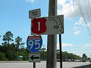
As is the case with all Florida roads with Federal designations, the entirety of US 1 has a hidden Florida Department of Transportation
designation: State Road 5 south of Callahan
(except for 11 miles (18 km) as SR 805 in Palm Beach County
); State Road 15
north of Callahan. US 1 is a designated Blue Star Memorial Highway
along its entire route through the state. Markers are placed at various locations, including one in Rockledge, Florida
and Fort Lauderdale, Florida
. State Road A1A
runs next to the Atlantic Ocean
, roughly parallel to US 1 for much of its path through Florida.
.svg.png) US 1 was designated nationwide on November 11, 1926, running from Miami, Florida
US 1 was designated nationwide on November 11, 1926, running from Miami, Florida
north to Fort Kent, Maine
. The label was generally applied to the Atlantic Highway, except between Jacksonville, Florida
and Augusta, Georgia
, where a more inland route was chosen. In Florida, US 1 was designated along the full length of State Road 4. South of Jacksonville, this was both the Atlantic Highway and the eastern division of the Dixie Highway
; the route from Jacksonville northwest into Georgia was a Jacksonville-Macon, Georgia
Dixie Highway connector.
An extension in the 1930s or 1940s took US 1 south from Miami over the Overseas Highway
(State Road 4A) to Key West, where it still ends today. The part of US 1 between Miami and Jacksonville has been replaced by Interstate 95 for most through traffic.
In Florida, where signs for U.S. highways formerly had different colors for each highway, the "shield" for US 1 was red. Florida began using the colored shields in 1956, but during the 1980s the MUTCD was revised to specify only a black and white color scheme for U.S. Highway shields. As such, Federal funds were no longer available to maintain the colored signs. On August 27, 1993, the decision was made to no longer produce colored signs. Since then, the remaining colored signs have gradually been replaced by black-and-white signs; at present, there are a few rare colored ones still in place.
 US 1 officially begins at the Monroe County courthouse at the intersection of Whitehead and Fleming Streets. It proceeds south as Whitehead Street until the intersection with Truman Avenue, which takes it east through central Key West
. Truman Avenue becomes North Roosevelt Boulevard about a mile east, and remains so until leaving the island. A small bridge that connects Key West is the southern terminus of the Overseas Highway
which US 1 is known as between Stock Island
and mainland Florida.
After Stock Island, US 1 proceeds through Boca Chica Key
, Rockland Key
, East Rockland Key
, Big Coppitt Key
, Saddlebunch Keys
, Sugarloaf Key, Park Key
, Cudjoe Key
, Summerland Key
, Ramrod Key
, Middle Torch Key
, Little Torch Key
, Big Pine Key
, Scout Key, Spanish Harbor Key
, The Bahia Honda Bridge, Bahia Honda Key
, Ohio Key
, Missouri Key
, and Little Duck Key
. After Little Duck Key, it enters Knight's Key
, Boot Key
, Key Vaca
and the city of Marathon
via the Seven Mile Bridge
, thus leaving the lower Keys.
US 1 runs through Marathon as a 4 lane road. After Key Vaca it runs through Fat Deer Key
, Long Point Key
, Crawl Key
, Grassy Key
, Little Conch Key
, Conch Key, Long Key
, the city of Layton
, Craig Key
and the village of Islamorada including Tea Table Key
, Lower Matecumbe Key
, Upper Matecumbe Key
and Windley Key
. After leaving Islamorada is crosses Plantation Key
. At Tavernier
on Key Largo
, it temporarily splits into two, one way road sections through the city. On the north end of Key Largo just before crossing into the mainland and Miami-Dade County
, it intersects Monroe County Road 905, an alternate route out of the Keys.
on the west. It is named South Dixie Highway from the county line to Miami. Its first major intersection is with the north end of Card Sound Road in Florida City
. Southbound travelers approaching this intersection see a sign that tells them to take Card Sound Road if the light on it is flashing.
Between Florida City and Homestead, it meets the southern end of the Homestead Extension of Florida's Turnpike
and intersects State Road 9336, providing access to either Everglades National Park
or Biscayne National Park
. It runs parallel to Florida's Turnpike through from Homestead
until passing under it again near Cutler Bay
just after an intersection with State Road 989. At this point the road has turned northeast towards Miami. In Perrine
, it meets State Road 994. Next comes South Miami
, where it intersects two expressways, the Palmetto Expressway (State Road 826), and the Snapper Creek Expressway (State Road 878), as well as State Road 959. It then makes a short pass through Coral Gables
before entering Miami
.
 In Miami, US 1 first intersects State Road 976, followed by the south end of State Road 9, which ends up running concurrent with Interstate 95
, and is also I-95's state designation through most of Florida. About a mile east, it meets the southern terminus of I-95 itself. At this point both roads turn north and run relatively parallel through the state. It then proceeds to meet US 41 before crossing the Miami River
via a bascule bridge
into downtown. The road is then named Biscayne Boulevard through the rest of Miami-Dade County as it proceeds north on Biscayne Bay
.
near Hallandale Beach
, US 1 first intersects State Road 858. Next it meets the eastern terminus of State Road 824, which provides access to Miramar
and Pembroke Pines
. Entering Hollywood
, it intersects State Road 820 in a traffic circle
around Anniversary Park. In Dania Beach
it meets State Road 822 and State Road 848. Here State Road A1A
also begins running concurrent with the road just south of Fort Lauderdale-Hollywood International Airport
for a few miles. Near the southeastern corner of the airport it meets the eastern terminus State Road 818. It then proceeds to go around the eastern edge of the airport. On the northeastern corner it meets I-595
. Now in Fort Lauderdale
as Federal Highway, it meets the eastern terminus of State Road 84. Another ½ mile past here A1A ends its concurrency with US 1 and returns to the barrier island. 1 mile south of downtown it meets the eastern terminus of State Road 736. The road enters downtown Fort Lauderdale via the New River Tunnel
, the only road tunnel in the state. The next major intersection is with State Road 842. It then turns east for 1 mile in concurrency with State Road 838 before separating again and turning north. The last two major intersections in Fort Lauderdale are with State Road 816 and State Road 870. US 1 then enters Pompano Beach
. As it makes its way through Pompano Beach it intersects State Road 814. It then passes by the Pompano Beach Airpark
and the Pompano Beach Golf Club. The road then proceeds to enter Deerfield Beach
, where it meets SE 10th Street and State Road 810. It then crosses the Hillsboro Canal
and exits Deerfield Beach and Broward County.
and Boca Raton
, it forms the western boundary to Royal Palm Yacht and Country Club, meeting with the northern terminus of the southern section of State Road 811. It passes through the heart of Boca Raton, becoming a divided road with three lanes each, becoming the eastern terminus of State Road 808, as well as intersecting State Road 800, and becoming the eastern terminus of State Road 794. US 1 then enters Delray Beach
, becoming a one-way pair
just north of Linton Boulevard, and meets State Road 806 in central Delray Beach. US 1 becomes a divided highway again, entering Boynton Beach
, State Road 804 runs concurrent for 2 blocks, providing access to local beaches at Ocean Ridge via the Intercoastal Waterway. At the city limits of Lake Worth
and Lantana
, just north of Lantana Road, US 1's hidden designation, State Road 5 splits and runs parallel to US 1 a few blocks to the east. In central Lake Worth US 1 intersects State Road 802. Entering West Palm Beach
, it first intersects State Road 882, followed by US 98/State Road 80
. At Belvedere Road, it meets the northern end of State Road 5. In central West Palm Beach, it intersects State Road 704, where US 1 becomes a one way pair through the heart of West Palm Beach. A mile north of SR 704, A1A begins running concurrent with US 1. At Palm Beach Lakes Boulevard, the one way pair ends for US 1, continuing north for 11 blocks, until it hits 23rd/25th street, becoming a one way pair for 4 blocks, as US 1 moves two blocks west as it moves north. US 1 leaves West Palm Beach and enters Riviera Beach
via a bridge over the Port of Palm Beach
. In Riviera Beach, US 1's concurrency with SR A1A ends at State Road 708. In North Palm Beach
it meets the eastern terminus of State Road 850 and State Road 786, where SR A1A becomes concurrent with US 1 for about 1.25 miles before splitting off at the southern end of Juno Beach
. In Jupiter
it intersects State Road 706, and has another concurrency with SR A1A just south of the Jupiter Inlet. Entering Tequesta
at the northern end of the inlet, US 1 then meets up with the northern terminus of the northern portion of SR 811, and leaves Palm Beach County north of County Line Road.
before crossing over the Florida East Coast Railway
tracks. At the southern end of Hobe Sound
, A1A splits off onto its own route. The two roads parallel each other until Stuart
. Through the center of Hobe Sound it intersects County Road 708. It then leaves Hobe Sound and enters Port Salerno
before it enters the heart Stuart, where it intersects State Road 714 near SR 714's eastern terminus at the northwestern end of Witham Field
. SR 714 ends less than a mile east at A1A. Through the center of Stuart it meets State Road 76. US 1 then crosses a bridge over the St. Lucie River
. North of the bridge it crosses over the Florida East Coast Railway tracks again and meets State Road 707. Two miles north of the river, it leaves Stuart and enters Jensen Beach
, intersecting Jensen Beach Boulevard and passing by Treasure Coast Square
. One and a half miles north of Treasure Coast Square, US 1 leaves Martin County.
As US 1 enters Port Saint Lucie it first meets the eastern terminus of Port Saint Lucie Boulevard. In the future, it will intersect with the Crosstown Parkway approximately halfway between Prima Vista and PSL Boulevard (the final routing over the Saint Lucie River is still being worked out). Continuing north into White City
it intersects County Road 712 (Midway Road). In Fort Pierce
it meets the eastern terminus of State Road 70 and State Road 68. A one mile long concurrency with A1A begins a few blocks north of SR 68 as the two roads enter the village of Saint Lucie. After A1A diverges back to its own route to the beach, US 1 intersects State Road 608. As it continues north of it meets the eastern terminus of State Road 615, State Road 614, as well as State Road 713. North of SR 713, US 1 veers east, crosses the Florida East Coast Railway
tracks, and leaves St. Lucie County.
US 1 enters Indian River County
just north of the SR 713 intersection, with its first major intersection in the county being Indian River County Road 606 in Oslo
. US 1 then runs parallel with the Florida East Coast Railroad, entering central Vero Beach
, where it's locally known as Commerce Boulevard. It intersects SR 656
(16th/17th Street), and State Road 60 (20th Street), and passes by the eastern end of the Vero Beach Municipal Airport. At the northeast end of the airport, US 1 has an intersection with State Road 605, with SR 605 paralleling US 1 one block to the west before leaving Vero Beach. North of Vero Beach, US 1 travels through the villages of Gifford
and Winter Beach
. In Wabasso
, US 1 intersects State Road 510
, where US 1 begins a concurrency with Indian River Lagoon Scenic Highway
. US 1 then intersects with SR 605 one block north of SR 510. US 1 then travels north to central Sebastian
, where it intersects with CR 512 (Sebastian Boulevard), providing access to Fellsmere
and Interstate 95
. It then enters Roseland
, intersecting CR 505 a half mile south of US 1's crossing of the St. Sebastian River, where it leaves Indian River County.
 At the Volusia County line
near Scottsmoor
, it first intersects CR 5A, a 1 miles (1.6 km) spur route
of the road itself. Between Titusville
and the Volusia County line
, it is normally close to Interstate 95
. South of CR 402, it joins the Indian River Lagoon Scenic Highway
. In southern Titusville
, it intersects State Road 50. At the interchange of NASA Parkway is the main entrance of the John F. Kennedy Space Center on Merritt Island. Near Camp Road is CR 515 and the Indian River Lagoon Scenic Highway
follows that road for 14 miles (22.5 km). At State Road 528, it marks the southern terminus of the Indian River Lagoon Scenic Highway
and the only freeway in Brevard County to intersect U.S. Route 1. Next, it enters the city of Cocoa
. It passes Historic Cocoa Village on the west side. Immediately, it enters the city of Rockledge
. This time, the road runs SSE-NNW along the Indian River Lagoon
(south of CR 515 when it joins the Indian River Lagoon Scenic Highway
again). It then enters Pineda
, a community east of Suntree
. 1.8 miles (2.9 km) south of the community is State Road 404 or the Pineda Causeway. It immediately enters Palm Shores
, the smallest incorporated place in Brevard County, which is part of Melbourne
. Now it enters Melbourne
. At Parkway Drive, it intersects Pineapple Avenue to the east. It passes Eau Gallie
also a part of Melbourne
, home of State Road 518. After crossing the Elbow Creek Bridge, it intersects with State Road 507. It provides access to Fellsmere
, about 20 miles (32.2 km) south of this intersection. It then goes along the Indian River Lagoon
until the intersection of U.S. Route 192 at the 1900 Building
. When it enters the zip code of 32905, it enters northeastern Palm Bay
. It goes through the central area of the city, with the intersection of Palm Bay Road. South of the intersection of Ting Road, it enters Malabar
, first intersecting State Road 514. Before exiting Brevard County and into Indian River County
, it intersects Valkaria and Grant Roads, inside Grant-Valkaria
, and Micco Road, providing access to Deer Run. Finally, it crosses the St. Sebastian River and enters Indian River County
.
line near Ormond Beach
, the highway still remains west of Interstate 95
. Before the overpass
, it passes through a mobile home
park, then met some business' around Interstate 95
, such as Burger King
. Next, it enters the city of Ormond Beach
. The section in the entire city is known as Younge Street. About 2 miles (3.2 km) south of that point is the Tomoka River
, a river through rural Daytona Beach
. After the bridge is State Road 5A
, a bypass of Downtown
Daytona Beach
. It then arrives in central Ormond Beach
with the intersection of State Road 40 and running parallel with Volusia County Road 4079. The next settlement is Holly Hill
, a suburb
close to central Daytona Beach
. Inside an area called Central Holly Hill, it meets LPGA Boulevard (11th Street in the street grid), which is home to the LPGA
headquarters
and provides an alternative route to DeLand
via U.S. Route 92. At the southern border of Holly Hill is SR 430
, Immediately after the intersection is Daytona Beach
. It is locally known as Ridgewood Avenue. 4 bridges cross to the barrier island
. They are:Seabreeze Bridge, Main Street Bridge, Carlton Blank Bridge
(carries US 92) and Memorial Bridge. Outside Central Daytona Beach is SR 400, which will become unsigned on Interstate 4. It immediately enters South Daytona
. Big Tree Road and Reed Canal Road, one of the 3 major roads in the city, provide access to State Road 483 outside of the city. Next, it enters Port Orange
, with an immediate intersection of State Road 421 to the east and State Road A1A
from the west. A1A connects to the barrier island via the Port Orange Causeway
. A1A runs concurrent southbound until State Road 528. At the southern causeway of New Smyrna Beach
, it spurs off as CR A1A. Back in Port Orange
, for a moment, it enters Allandale
. State Road 5A
ends at US 1, and Volusia County Road 4079 forms a cul-de-sac
. Then, US 1 crosses Rose Bay and leaves Port Orange
, and immediately crosses Spruce Creek west of Ponce Inlet
to New Smyrna Beach
In the heart of the city, State Road 44 actually goes over US 1. The next settlement is Edgewater
. Volusia County Road 4136 (or Park Avenue) is the next intersection. Also featured in Edgewater
is the eastern terminus of SR 442
, although a short section of Indian River Drive extends 1/10 of a mile eastward. The next settlements is Oak Hill
, home of the northern terminus of State Road 3. In central Oak Hill, Volusia County Road 4164 meet. At the intersection of State Road 3, US 1 immediately turns to a northeast-southwest route for the rest of the journey to Brevard County
. Near Scottsmoor
, it enters Brevard County
.
at the Pellicer Creek bridge, it first intersects unpaved Old Kings Road before it enters Palm Coast
. Palm Coast Parkway is the next intersection, providing access to Interstate 95
. It now consists the western boundary of Palm Coast
. Beyond that point, no streets intersect US 1. It enters Bunnell
anyway and intersects Old Brick Road, which provides access to Flagler Estates
. In central Bunnell
, it is concurrent
with State Road 100 (also the terminus of State Road 20
) until the next traffic light
that supplies the termini of SR 11
. State Road 100 heads eastward. At the southern end of Belle Terre Parkway, it enters the neighborhood of Dupoint, now part of Palm Coast
. Inside Korona
. it finally intersects Old Dixie Highway. It becomes a northwest-southeast route to/from Interstate 95
. It finally enters Volusia County
.
, it first arrives in Durbin, an unincorporated
community. It has access to Palm Valley
through the intersection CR 210 East, on the barrier island via Valley Ridge Boulevard. Cutting through wetlands, it arrives in St. Augustine
. Within the city limits, it is named, Ponce De Leon Boulevard. Immediately, it intersects
Business Route 1, a major tourist route through Old St Augustine
. State Road 16 immediately comes next. Then, it runs along the floodplain of the San Sebastian River, which forms the western border of Old St. Augustine
. After crossing the San Sebastian River, it intersects the west/south terminus of U.S. Highway 1 Business (St. Augustine, Florida) with the continuation of King St. going west. Just outside of St. Augustine
, it meets State Road 207. After that is State Road 312. Then, it enters St. Augustine South
, an unincorporated
community south of St. Augustine
. Just after crossing Moultrie Creek is St. Augustine Shores
. The next intersection is a spur route
of State Road 207, SR 206
. There won't be any business' until the Interstate 95
intersection. Just south of the Interstate 95
interchange is St. Johns County Road 204, which provides access to Flagler Estates
. Finally, it crosses Pellicer Creek and enters Flagler County
.
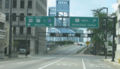
state line at St. Marys River
, it runs concurrent with U.S. Route 23, which terminates in Downtown Jacksonville, U.S. Route 301, and State Road 15, which also starts at the St. Marys River
. It first passes by a welcome center in Boulogne
, the first Florida
settlement passed on U.S. Route 1. Before the welcome center, it intersects CR 121/Lake Hampton Road, which provides an alternative route to State Road 2 and Georgia State Road 94. The incorporated town Hilliard
is home to the intersection of CR 108. The town
of Callahan
contains the northern terminus of State Road A1A
, the most famous state route in the state as it mostly goes along the Atlantic Ocean
. U.S. Route 301 carries now State Road 200 through western Jacksonville
and Baldwin
. At the eastern part of the town is the northern terminus of State Road 115. The final place before it enters Duval County
is Nassau Village-Ratliff
. Finally, it crosses Thomas Creek and into Duval County
.
 Beginning at the Thomas Creek bridge at Nassau Village-Ratliff
, it enters Jacksonville
. Currently, it is concurrent with U.S. Route 23 and State Road 15. The first major intersection is State Road 104
, then immediately crossing the Trout River
, a tributary
of the St. Johns River
. Just before the I-295
intersection is Trout River Boulevard. After I-295
, it crosses the Little Trout River
. Currently, the road is 4 lanes wide. State Road 111
intersects the route 3 miles (4.8 km) later and crosses the Ribault River
. Then, it comes up to an interchange of Martin Luther King Jr. Parkway. U.S. Route 1 follows the expressway
, while U.S. Route 23 continues southeast on New Kings Road to Downtown Jacksonville. By a cloverleaf
interchange, it meets Interstate 95
. At the Main Street intersection (U.S. Route 17), U.S. Route 1 runs concurrent with the street and runs southward. At the southern terminus of U.S. Route 23, U.S. Route 1/U.S. Route 17/U.S. Route 90 turns into a one-way pair
(Ocean Street northbound/Main Street southbound). Near the Main Street Bridge
, U.S. Route 17 heads east–west. U.S. Route 90/U.S. Route 1 crosses the St. Johns River
via the Main Street Bridge
. After the bridge, the road becomes local-express lanes
of Interstate 95
. U.S. Route 90 spurs off as Beach Boulevard. Finally, the local-express lanes
becomes Philips Highway until the St. Johns County line
.
. It begins at Interstate 95
at Exit 348. The first major intersection of the road is St. Augustine Road. It provides access to State Road 13 as well as the next major intersection of Emerson St which is signed as U.S. Highway 1 Alternate and State Road 126. Palm Trees line the median of the road until Clinton Avenue. The next intersection is State Road 109 (or University Boulevard). In some local maps, Bowden Road intersects University Boulevard, but it has a dead end
at the Florida East Coast Railroad. Bowden Road is a southbound access road for Interstate 95
, while University Boulevard has northbound access for I-95. State Road 152
(locally known as Baymeadows Road) is the next intersection. Baymeadows Way, a short alternative of Baymeadows Road if there's a traffic accident on the intersection. A short road that connects State Road 13, Sunbeam Road, intersects next. Philips Highway then meets Interstate 95
. The area near this intersection is a large commercial area, it especially contains multiple furniture stores. A 1/2 mile southeast is State Road 115. It is the southern terminus of that route. Next, it intersects State Road 9A (future Interstate 295
), the eastern half of the loop
around Downtown Jacksonville. At the southern part of the interchange is Greenland Road. At the neighborhood of Bayard
, it intersects Old St. Augustine Road, the final intersection in Jacksonville
. At the St. Johns County line
, it intersects Race Track Road. Philips Highway ends and enters St. Johns County
.
}
|Interchange; northbound exit only
|-
|
|
|-
|Cutler Bay
|
|
|-
|Palmetto Bay
|
|
|-
|rowspan=4|Pinecrest
|
|Interchange; northbound exit and southbound entrance
|-
|
|
|-
|
|Interchange; no access from US 1 north to SR 878 west
|-
|
|
|-
|rowspan=2|South Miami
|
|
|-
|
|
|-
|rowspan=9|Miami
|
|Interchange; northbound exit and southbound entrance
|-
|
|
|-
|
|
|-
|
 Northeast 10th Street to I-95 / SR 836 west – Miami International Airport
|
|-
| – Beaches
|Interchange; no access from US 1 south to I-395 east
|-
|
|
|-
|
|Interchange
|-
|
|
|-
|
|
|-
|rowspan=2|North Miami
|
|
|-
|
|
|-
|rowspan=2|North Miami Beach
|
|
|-
|
|
|-
|rowspan=2|Aventura
|
|
|-
| Northeast 203rd Street west, Ives Dairy Road to I-95
|Interchange; no northbound entrance
|-
|rowspan=20|Broward
|rowspan=2|Hallandale
|
|
|-
|rowspan=2|
|rowspan=2|
|-
|rowspan=4|Hollywood
|-
|
|
|-
|
|
|-
|
|
|-
|Dania Beach
|
|South end of SR A1A overlap
|-
|rowspan=9|Fort Lauderdale
| – International Airport
, Port Everglades
|Interchange
|-
|
|
|-
|
|North end of SR A1A overlap
|-
|
|
|-
|
|
|-
|
|South end of SR 838 overlap
|-
|
|North end of SR 838 overlap
|-
|
|
|-
|
|
|-
|rowspan=2|Pompano Beach
|
|
|-
|
|
|-
|rowspan=2|Lighthouse Point
|
|
|-
|
|
|-
|rowspan=10|Palm Beach
|rowspan=4|Boca Raton
|
|
|-
|, Florida Atlantic University
|
|-
|
|
|-
|
|
|}
Florida
Florida is a state in the southeastern United States, located on the nation's Atlantic and Gulf coasts. It is bordered to the west by the Gulf of Mexico, to the north by Alabama and Georgia and to the east by the Atlantic Ocean. With a population of 18,801,310 as measured by the 2010 census, it...
runs 541 miles (870.7 km) along the state's east coast from Key West
Key West
Key West is an island in the Straits of Florida on the North American continent at the southernmost tip of the Florida Keys. Key West is home to the southernmost point in the Continental United States; the island is about from Cuba....
to its crossing of the St. Marys River
St. Marys River (Florida/Georgia)
The St. Marys River is a river in the southeastern United States. It is named after the Irish Saint Mary. From near its source in the Okefenokee Swamp, to its mouth at the Atlantic Ocean, it forms a portion of the border between the U.S. states of Georgia and Florida...
into Georgia
Georgia (U.S. state)
Georgia is a state located in the southeastern United States. It was established in 1732, the last of the original Thirteen Colonies. The state is named after King George II of Great Britain. Georgia was the fourth state to ratify the United States Constitution, on January 2, 1788...
north of Boulogne
Boulogne, Florida
Boulogne is an unincorporated community in Nassau County, Florida, United States. Boulogne is located in the northern part of the county, near the St. Marys River. Highways passing through the town include US 301 and U.S...
, and south of Folkston. US 1 was designated through Florida when the U.S. Highway System was established in 1926.
US 1 runs 541 miles (870.7 km) in the state of Florida, and is maintained by FDOT. From it's national southern terminus in Key West, it carries the Overseas Highway
Overseas Highway
The Overseas Highway is a highway carrying U.S. Route 1 through the Florida Keys. Large parts of it were built on the former right-of-way of the Overseas Railroad, the Key West Extension of the Florida East Coast Railway. Completed in 1912, the Overseas Railroad was heavily damaged and partially...
, the Keys main highway north to the mainland, entering South Florida. From South Florida to Jacksonville, US 1 runs close to the coastline of the Atlantic Ocean
Atlantic Ocean
The Atlantic Ocean is the second-largest of the world's oceanic divisions. With a total area of about , it covers approximately 20% of the Earth's surface and about 26% of its water surface area...
and the Intracoastal Waterway
Intracoastal Waterway
The Intracoastal Waterway is a 3,000-mile waterway along the Atlantic and Gulf coasts of the United States. Some lengths consist of natural inlets, salt-water rivers, bays, and sounds; others are artificial canals...
, generally east of I-95
Interstate 95 in Florida
Interstate 95 is the main Interstate Highway on the east coast of the United States; it serves the Atlantic coast of Florida. It begins at a partial interchange with U.S. Highway 1 just south of downtown Miami, and heads north past Daytona Beach and Jacksonville to the Georgia state line at the St...
and west of State Road A1A
Florida State Road A1A
State Road A1A is a Florida State Road that runs mostly along the Atlantic Ocean, with sections from Key West at the southern tip of Florida, to Callahan, just south of Georgia. It is the main road through most oceanfront towns. SR A1A is designated the A1A Scenic and Historic Coastal Highway, a...
, running roughly parallel with both roads. North of Jacksonville, US 1 curves inland towards the St. Mary's River as it enters Georgia.
As is the case with all Florida roads with Federal designations, the entirety of US 1 has a hidden Florida Department of Transportation
Florida Department of Transportation
The Florida Department of Transportation is a decentralized agency charged with the establishment, maintenance, and regulation of public transportation in the state of Florida. The department was formed in 1969. It absorbed the powers of the Florida State Road Department...
designation: State Road 5 south of Callahan
Callahan, Florida
Callahan is a town in Nassau County, Florida, United States, adjacent to Downtown Jacksonville. The population was 962 at the 2000 census.-Geography:Callahan is located at ....
(except for 11 miles (18 km) as SR 805 in Palm Beach County
Palm Beach County, Florida
Palm Beach County is the largest county in the state of Florida in total area, and third in population. As of 2010, the county's estimated population was 1,320,134, making it the twenty-eighth most populous in the United States...
); State Road 15
State Road 15 (Florida)
State Road 15 is part of the Florida State Road System. It runs from SR 80/SR 880 at Belle Glade north along the east shore of Lake Okeechobee to Okeechobee. Then it runs north to SR 500 at Holopaw, and northwest along SR 500 to Ashton State Road 15 (commonly SR 15) is part of the Florida State...
north of Callahan. US 1 is a designated Blue Star Memorial Highway
Blue Star Memorial Highway
Blue Star Memorial Highways are highways in the United States that are marked to pay tribute to the U.S. armed forces. The National Council of State Garden Clubs, now known as National Garden Clubs, Inc., started the program in 1945 after World War II. The blue star was used on service flags to...
along its entire route through the state. Markers are placed at various locations, including one in Rockledge, Florida
Rockledge, Florida
Rockledge is the oldest city in Brevard County, Florida, United States. The population was 20,170 at the 2000 census. As of 2008, the estimated population according to the U.S. Census Bureau is 24,747. It is part of the Palm Bay–Melbourne–Titusville Metropolitan Statistical...
and Fort Lauderdale, Florida
Fort Lauderdale, Florida
Fort Lauderdale is a city in the U.S. state of Florida, on the Atlantic coast. It is the county seat of Broward County. As of the 2010 census, the city had a population of 165,521. It is a principal city of the South Florida metropolitan area, which was home to 5,564,635 people at the 2010...
. State Road A1A
Florida State Road A1A
State Road A1A is a Florida State Road that runs mostly along the Atlantic Ocean, with sections from Key West at the southern tip of Florida, to Callahan, just south of Georgia. It is the main road through most oceanfront towns. SR A1A is designated the A1A Scenic and Historic Coastal Highway, a...
runs next to the Atlantic Ocean
Atlantic Ocean
The Atlantic Ocean is the second-largest of the world's oceanic divisions. With a total area of about , it covers approximately 20% of the Earth's surface and about 26% of its water surface area...
, roughly parallel to US 1 for much of its path through Florida.
History
Miami, Florida
Miami is a city located on the Atlantic coast in southeastern Florida and the county seat of Miami-Dade County, the most populous county in Florida and the eighth-most populous county in the United States with a population of 2,500,625...
north to Fort Kent, Maine
Fort Kent, Maine
Fort Kent is a town in Aroostook County, Maine, United States. The population was 4,097 in the 2010 census. Fort Kent is home to an Olympic biathlete training center, an annual CAN-AM dogsled race, and the Fort Kent Blockhouse, built in reaction to the Aroostook War and in modern times designated...
. The label was generally applied to the Atlantic Highway, except between Jacksonville, Florida
Jacksonville, Florida
Jacksonville is the largest city in the U.S. state of Florida in terms of both population and land area, and the largest city by area in the contiguous United States. It is the county seat of Duval County, with which the city government consolidated in 1968...
and Augusta, Georgia
Augusta, Georgia
Augusta is a consolidated city in the U.S. state of Georgia, located along the Savannah River. As of the 2010 census, the Augusta–Richmond County population was 195,844 not counting the unconsolidated cities of Hephzibah and Blythe.Augusta is the principal city of the Augusta-Richmond County...
, where a more inland route was chosen. In Florida, US 1 was designated along the full length of State Road 4. South of Jacksonville, this was both the Atlantic Highway and the eastern division of the Dixie Highway
Dixie Highway
The Dixie Highway was a United States automobile highway, first planned in 1914 to connect the US Midwest with the Southern United States. It was part of the National Auto Trail system, and grew out of an earlier Miami to Montreal highway. The final result is better understood as a small network of...
; the route from Jacksonville northwest into Georgia was a Jacksonville-Macon, Georgia
Macon, Georgia
Macon is a city located in central Georgia, US. Founded at the fall line of the Ocmulgee River, it is part of the Macon metropolitan area, and the county seat of Bibb County. A small portion of the city extends into Jones County. Macon is the biggest city in central Georgia...
Dixie Highway connector.
An extension in the 1930s or 1940s took US 1 south from Miami over the Overseas Highway
Overseas Highway
The Overseas Highway is a highway carrying U.S. Route 1 through the Florida Keys. Large parts of it were built on the former right-of-way of the Overseas Railroad, the Key West Extension of the Florida East Coast Railway. Completed in 1912, the Overseas Railroad was heavily damaged and partially...
(State Road 4A) to Key West, where it still ends today. The part of US 1 between Miami and Jacksonville has been replaced by Interstate 95 for most through traffic.
In Florida, where signs for U.S. highways formerly had different colors for each highway, the "shield" for US 1 was red. Florida began using the colored shields in 1956, but during the 1980s the MUTCD was revised to specify only a black and white color scheme for U.S. Highway shields. As such, Federal funds were no longer available to maintain the colored signs. On August 27, 1993, the decision was made to no longer produce colored signs. Since then, the remaining colored signs have gradually been replaced by black-and-white signs; at present, there are a few rare colored ones still in place.
Route description
The Keys
Key West, Florida
Key West is a city in Monroe County, Florida, United States. The city encompasses the island of Key West, the part of Stock Island north of U.S. 1 , Sigsbee Park , Fleming Key , and Sunset Key...
. Truman Avenue becomes North Roosevelt Boulevard about a mile east, and remains so until leaving the island. A small bridge that connects Key West is the southern terminus of the Overseas Highway
Overseas Highway
The Overseas Highway is a highway carrying U.S. Route 1 through the Florida Keys. Large parts of it were built on the former right-of-way of the Overseas Railroad, the Key West Extension of the Florida East Coast Railway. Completed in 1912, the Overseas Railroad was heavily damaged and partially...
which US 1 is known as between Stock Island
Stock Island
Stock Island is an island in the lower Florida Keys immediately east of Key West . Immediately northwest is Key Haven , from which it is connected by causeway with US 1 . The part north of U.S...
and mainland Florida.
After Stock Island, US 1 proceeds through Boca Chica Key
Boca Chica Key
Boca Chica Key is an island in the lower Florida Keys approximately 3 miles east of the island of Key West.U.S. 1 crosses the key at approximately mile markers 6.5—8, east of Key West....
, Rockland Key
Rockland Key
Rockland Key is an island in the lower Florida Keys about 4 miles east of Key West.U.S. 1 crosses the edge of the key at approximately mile markers 8-9.5, between Boca Chica Key and Big Coppitt Key....
, East Rockland Key
East Rockland Key
East Rockland Key is an island in the lower Florida Keys about 4 miles east of Key West.U.S. 1 crosses the edge of the key at approximately mile markers 8-9.5, between Boca Chica Key and Big Coppitt Key....
, Big Coppitt Key
Big Coppitt Key, Florida
Big Coppitt Key is a census-designated place and an unincorporated community in Monroe County, Florida, on an island of the same name in the lower Florida Keys. The CDP also includes the neighboring islands of Geiger Key and Shark Key. As of the 2000 census, it had a total population of 2,595. ...
, Saddlebunch Keys
Saddlebunch Keys
The Saddlebunch Keys are a series of mangrove islands about 7 miles east of Key West, Florida.The keys are scattered between Lower Sugarloaf Key and Shark Key.U.S...
, Sugarloaf Key, Park Key
Park Key
Park Key is an uninhabited island in the lower Florida Keys about 14 miles east of Key West. It is 1500 Meters long, and between 75 and 260 Meters wide . It measures 28,5 hectares in area....
, Cudjoe Key
Cudjoe Key, Florida
Cudjoe Key is a census-designated place in Monroe County, Florida, on an island of the same name in the lower Florida Keys. As of the 2000 census, the CDP had a total population of 1,695.It was originally called Littleton Island....
, Summerland Key
Summerland Key
Summerland Key is an island in the lower Florida Keys approximately 20 miles east of Key West.U.S. 1 crosses the island at approximately mile markers 24—25.5, between Ramrod Key and Cudjoe Key. The name appears on U.S...
, Ramrod Key
Ramrod Key
Ramrod Key is an island in the lower Florida Keys. Originally named Roberts Island, Ramrod Key was renamed for a ship named Ramrod, which was wrecked on a reef south of there in the early nineteenth century.-Description:...
, Middle Torch Key
Middle Torch Key
Middle Torch Key is an island in the lower Florida Keys.It is located between Ramrod Key and Little Torch Key.The southernmost tip of the key is on U.S. 1 , at approximately mile marker 28....
, Little Torch Key
Little Torch Key
Little Torch Key is an island in the lower Florida Keys.U.S. Route 1 , crosses the key at approximately mile markers 28—29...
, Big Pine Key
Big Pine Key, Florida
Big Pine Key is a census-designated place and unincorporated community in Monroe County, Florida, on an island of the same name in the Florida Keys. As of the 2000 census, the town had a total population of 5,032.-Geography:...
, Scout Key, Spanish Harbor Key
Spanish Harbor Key
Spanish Harbor Key is an island in the lower Florida Keys.U.S. 1 crosses the keys at approximately mile markers 35--36, between Bahia Honda Key and West Summerland Key....
, The Bahia Honda Bridge, Bahia Honda Key
Bahia Honda Key
Bahia Honda , is an island in the lower Florida Keys.U.S...
, Ohio Key
Ohio Key
Ohio Key is an island in the lower Florida Keys.U.S. 1 crosses the key at approximately mile marker 39, between Missouri Key and Bahia Honda Key....
, Missouri Key
Missouri Key
Missouri Key is a small island in the lower Florida Keys.U.S. 1 crosses the key at approximately mile marker 39.5, between Ohio Key and Little Duck Key....
, and Little Duck Key
Little Duck Key
Little Duck Key is a small island in the lower Florida Keys.U.S. 1 crosses the key at approximately mile marker 40, just west of the Seven Mile Bridge...
. After Little Duck Key, it enters Knight's Key
Knight's Key
Knight's Key is an island in the middle Florida Keys, located entirely within the borders of the city of Marathon, Florida.-Geography:U.S. 1 crosses the key at approximately mile marker 47, at the western end of Key Vaca and eastern end of the Seven Mile Bridge.-History:Prior to the completion of...
, Boot Key
Boot Key
Boot Key is an island in the middle Florida Keys located adjacent to Key Vaca. Boot Key is within the city limits of Marathon, Florida, USA. The island is largely undeveloped despite having a bridge spanning Boot Key Harbor to Key Vaca, which is now closed to pedestrian and vehicular...
, Key Vaca
Key Vaca
Key Vaca is an island in the middle Florida Keys, located entirely within the borders of the city of Marathon, Florida. It is often incorrectly identified as "Marathon Key."- Geography :Key Vaca is located between Fat Deer Key and Knight's Key...
and the city of Marathon
Marathon, Florida
Marathon is a city on Knight's Key, Boot Key, Key Vaca, Fat Deer Key, Long Point Key, Crawl Key and Grassy Key islands in the middle Florida Keys, in Monroe County, Florida, in the United States. As of the 2000 census, the city had a total population of 10,255. As of 2005, the population estimated...
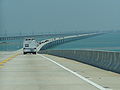
via the Seven Mile Bridge
Seven Mile Bridge
The Seven Mile Bridge is a famous bridge in the Florida Keys, in Monroe County, Florida, United States. It connects Knight's Key in the Middle Keys to Little Duck Key in the Lower Keys...
, thus leaving the lower Keys.
US 1 runs through Marathon as a 4 lane road. After Key Vaca it runs through Fat Deer Key
Fat Deer Key
Fat Deer Key is an island in the middle Florida Keys.U.S. 1 crosses the key at approximately mile markers 53.5-56, between Long Point Key and Key Vaca....
, Long Point Key
Long Point Key
Long Point Key is an island in the middle Florida Keys.U.S. 1 traverses the key between Crawl Key and Fat Deer Key, which is part of a long stretch of road known as the Grassy Key Causeway....
, Crawl Key
Crawl Key
Crawl Key is an island in the middle Florida Keys.U.S. 1 traverses the key between Grassy Key and Long Point Key, which is part of a long stretch of road known as the Grassy Key Causeway....
, Grassy Key
Grassy Key
Grassy Key, Florida is an island in the middle Florida Keys.It is located on U.S. 1 , at approximately mile markers 57—60, below the Conch Keys. It has an area of 3.65 km², with a population of 974 as of the census 2000....
, Little Conch Key
Little Conch Key
Little Conch Key is an island in Monroe County, Florida, United States. It is located in the middle Florida Keys. U.S. 1 crosses the key at approximately mile marker 62.2, between Duck Key and Conch Key. It is part of the census-designated place of Duck Key.Little Conch Key is also known as...
, Conch Key, Long Key
Long Key
Long Key is an island in the middle Florida Keys.U.S. 1 crosses the key at approximately mile markers 65.5--71, between Fiesta Key and Conch Key....
, the city of Layton
Layton, Florida
Layton is a city on the island of Long Key in Monroe County, Florida, United States. The population was 186 at the 2000 census. As of 2004, the population estimated by the U.S. Census Bureau is 204 .-History of Layton:...
, Craig Key
Craig Key
Craig Key is an island in the middle Florida Keys.U.S. 1 crosses the key at approximately mile marker 72, between Lower Matecumbe Key and Fiesta Key.-History:...
and the village of Islamorada including Tea Table Key
Tea Table Key
Teatable Key is an island in the upper Florida Keys.It is located on U.S. 1 at mile marker 75.All of the key is within the Village of Islamorada as of November 4, 1997, when it was incorporated....
, Lower Matecumbe Key
Lower Matecumbe Key
Lower Matecumbe Key is an island in the upper Florida Keys.It is located on U.S. 1 between mile markers 75--78.All of the key is within the Village of Islamorada as of November 4, 1997, when it was incorporated....
, Upper Matecumbe Key
Upper Matecumbe Key
Upper Matecumbe Key is an island in the upper Florida Keys.U.S. 1 crosses the key at approximately mile markers 79—83.5, between Windley Key and Lower Matecumbe Key....
and Windley Key
Windley Key
Windley Key is an island in the upper Florida Keys in Monroe County, Florida, United States.U.S. 1 crosses the key at approximately mile markers 84—85.5, between Plantation Key and Upper Matecumbe Key....
. After leaving Islamorada is crosses Plantation Key
Plantation Key
Plantation Key is an island in Monroe County, Florida, United States. It is located in the upper Florida Keys on U.S. 1 , between Key Largo and Windley Key....
. At Tavernier
Tavernier, Florida
Tavernier is a census-designated place in Monroe County, Florida, on an island named Key Largo in the upper Florida Keys. The population was 2,173 at the 2000 census.-Geography:Tavernier is located at ....
on Key Largo
Key Largo
Key Largo is an island in the upper Florida Keys archipelago and, at long, the largest of the Keys. It is also the northernmost of the Florida Keys in Monroe County, and the northernmost of the Keys connected by U.S. Highway 1...
, it temporarily splits into two, one way road sections through the city. On the north end of Key Largo just before crossing into the mainland and Miami-Dade County
Miami-Dade County, Florida
Miami-Dade County is a county located in the southeastern part of the state of Florida. As of 2010 U.S. Census, the county had a population of 2,496,435, making it the most populous county in Florida and the eighth-most populous county in the United States...
, it intersects Monroe County Road 905, an alternate route out of the Keys.
Miami-Dade County
For the first 14 miles in Miami-Dade County, US 1 is a 2 lane road bordering the Everglades National ParkEverglades National Park
Everglades National Park is a national park in the U.S. state of Florida that protects the southern 25 percent of the original Everglades. It is the largest subtropical wilderness in the United States, and is visited on average by one million people each year. It is the third-largest...
on the west. It is named South Dixie Highway from the county line to Miami. Its first major intersection is with the north end of Card Sound Road in Florida City
Florida City, Florida
Florida City is a city in Miami-Dade County, Florida, United States and is the southernmost municipality in the South Florida metropolitan area, which had an estimated population of 5,413,212 in 2007. The population was 7,843 at the 2000 census. As of 2004, the population estimated by the U.S....
. Southbound travelers approaching this intersection see a sign that tells them to take Card Sound Road if the light on it is flashing.
Between Florida City and Homestead, it meets the southern end of the Homestead Extension of Florida's Turnpike
Heft
Heft and similar can mean:*Robert G. Heft, a designer of the 50-star and 51-star versions of the USA flag*HEFT, the Homestead Extension of Florida's Turnpike...
and intersects State Road 9336, providing access to either Everglades National Park
Everglades National Park
Everglades National Park is a national park in the U.S. state of Florida that protects the southern 25 percent of the original Everglades. It is the largest subtropical wilderness in the United States, and is visited on average by one million people each year. It is the third-largest...
or Biscayne National Park
Biscayne National Park
Biscayne National Park is a U.S. National Park located in southern Florida, due east of Homestead. The park preserves Biscayne Bay, one of the top scuba diving areas in the United States. Ninety-five percent of the park is water. In addition, the shore of the bay is the location of an extensive...
. It runs parallel to Florida's Turnpike through from Homestead
Homestead, Florida
Homestead is a city in Miami-Dade County, Florida, United States nestled between Biscayne National Park to the east and Everglades National Park to the west. Homestead is primarily a Miami suburb and a major agricultural area....
until passing under it again near Cutler Bay
Cutler Bay, Florida
Cutler Bay, historically called Cutler Ridge, is an incorporated town in Miami-Dade County, Florida from SW 184th Street east of US-1 to the coast, and north of Black Point Marina, at...
just after an intersection with State Road 989. At this point the road has turned northeast towards Miami. In Perrine
Perrine, Florida
Perrine, Florida was an unincorporated community in Miami-Dade County about midway between Miami and Homestead. It is located at The community was named after Dr...
, it meets State Road 994. Next comes South Miami
South Miami, Florida
South Miami is a Miami suburban city in Miami-Dade County, Florida, United States. The population was 10,741 at the 2000 census and as of 2007, according to the U.S...
, where it intersects two expressways, the Palmetto Expressway (State Road 826), and the Snapper Creek Expressway (State Road 878), as well as State Road 959. It then makes a short pass through Coral Gables
Coral Gables, Florida
Coral Gables is a city in Miami-Dade County, Florida, southwest of Downtown Miami, in the United States. The city is home to the University of Miami....
before entering Miami
Miami, Florida
Miami is a city located on the Atlantic coast in southeastern Florida and the county seat of Miami-Dade County, the most populous county in Florida and the eighth-most populous county in the United States with a population of 2,500,625...
.
Interstate 95 in Florida
Interstate 95 is the main Interstate Highway on the east coast of the United States; it serves the Atlantic coast of Florida. It begins at a partial interchange with U.S. Highway 1 just south of downtown Miami, and heads north past Daytona Beach and Jacksonville to the Georgia state line at the St...
, and is also I-95's state designation through most of Florida. About a mile east, it meets the southern terminus of I-95 itself. At this point both roads turn north and run relatively parallel through the state. It then proceeds to meet US 41 before crossing the Miami River
Miami River (Florida)
The Miami River is a river in the United States state of Florida that drains out of the Everglades and runs through the Downtown and the city of Miami. The long river flows from the terminus of the Miami Canal at Miami International Airport to Biscayne Bay...
via a bascule bridge
Bascule bridge
A bascule bridge is a moveable bridge with a counterweight that continuously balances the span, or "leaf," throughout the entire upward swing in providing clearance for boat traffic....
into downtown. The road is then named Biscayne Boulevard through the rest of Miami-Dade County as it proceeds north on Biscayne Bay
Biscayne Bay
Biscayne Bay is a lagoon that is approximately 35 miles long and up to 8 miles wide located on the Atlantic coast of South Florida, United States. It is usually divided for purposes of discussion and analysis into three parts: North Bay, Central Bay, and South Bay. Its area is...
.
Broward County
Entering Broward CountyBroward County, Florida
-2000 Census:As of the census of 2000, there were 1,623,018 people, 654,445 households, and 411,645 families residing in the county. The population density was 1,346 people per square mile . There were 741,043 housing units at an average density of 615 per square mile...
near Hallandale Beach
Hallandale Beach, Florida
Hallandale Beach is a city in Broward County, Florida, United States. The city is named after Luther Halland, a worker for Henry Flagler's Florida East Coast Railroad. As of the 2010 census, the population was 37,113...
, US 1 first intersects State Road 858. Next it meets the eastern terminus of State Road 824, which provides access to Miramar
Miramar, Florida
Miramar is a city in Broward County, Florida, United States. The city was named after the Miramar district of Havana, Cuba. As of the 2010 census, the population was 122,041...
and Pembroke Pines
Pembroke Pines, Florida
Pembroke Pines is a city in Broward County, Florida, United States. The city had a population of 154,750 at the 2010 census, making it the second most populous city in Broward County, the tenth most populous in Florida, and the 150th most populous in the United States...
. Entering Hollywood
Hollywood, Florida
-Demographics:As of 2000, there were 59,673 households out of which 24.9% had children under the age of 18 living with them, 41.5% were married couples living together, 11.9% had a female householder with no husband present, and 42.2% were non-families. 34.4% of all households were made up of...
, it intersects State Road 820 in a traffic circle
Traffic circle
A traffic circle or rotary is a type of circular intersection in which traffic must travel in one direction around a central island. In some countries, traffic entering the circle has the right-of-way and drivers in the circle must yield. In many other countries, traffic entering the circle must...
around Anniversary Park. In Dania Beach
Dania Beach, Florida
Dania Beach is a city in Broward County, Florida, United States. As of the 2010 census, the city's population was 29,639. It is part of the South Florida metropolitan area, which was home to 5,564,635 people at the 2010 census. Dania Beach is the location of one of the largest jai alai frontons in...
it meets State Road 822 and State Road 848. Here State Road A1A
Florida State Road A1A
State Road A1A is a Florida State Road that runs mostly along the Atlantic Ocean, with sections from Key West at the southern tip of Florida, to Callahan, just south of Georgia. It is the main road through most oceanfront towns. SR A1A is designated the A1A Scenic and Historic Coastal Highway, a...
also begins running concurrent with the road just south of Fort Lauderdale-Hollywood International Airport
Fort Lauderdale-Hollywood International Airport
Fort Lauderdale – Hollywood International Airport is an international commercial airport located in unincorporated Broward County, Florida, three miles southwest of the central business district of Fort Lauderdale...
for a few miles. Near the southeastern corner of the airport it meets the eastern terminus State Road 818. It then proceeds to go around the eastern edge of the airport. On the northeastern corner it meets I-595
Interstate 595 (Florida)
Interstate 595 , also known as the Port Everglades Expressway and as the unsigned State Road 862, is a Interstate highway that connects Interstate 75 and Alligator Alley in the west with Florida's Turnpike, Interstate 95, Fort Lauderdale-Hollywood International Airport, US 1, and SR A1A before...
. Now in Fort Lauderdale
Fort Lauderdale, Florida
Fort Lauderdale is a city in the U.S. state of Florida, on the Atlantic coast. It is the county seat of Broward County. As of the 2010 census, the city had a population of 165,521. It is a principal city of the South Florida metropolitan area, which was home to 5,564,635 people at the 2010...
as Federal Highway, it meets the eastern terminus of State Road 84. Another ½ mile past here A1A ends its concurrency with US 1 and returns to the barrier island. 1 mile south of downtown it meets the eastern terminus of State Road 736. The road enters downtown Fort Lauderdale via the New River Tunnel
New River Tunnel
The New River Tunnel, also known as the Henry E. Kinney Tunnel, is one of three underwater road tunnels in Florida , that replaced the Federal Aid Highway Bridge, a drawbridge opened on August 26, 1926 and closed in 1958. It carries U.S. Route 1 underneath the New River and Las Olas Boulevard in...
, the only road tunnel in the state. The next major intersection is with State Road 842. It then turns east for 1 mile in concurrency with State Road 838 before separating again and turning north. The last two major intersections in Fort Lauderdale are with State Road 816 and State Road 870. US 1 then enters Pompano Beach
Pompano Beach, Florida
Pompano Beach ) is a city in Broward County, Florida, along the coast of the Atlantic Ocean just to the north of Fort Lauderdale. The nearby Hillsboro Inlet forms part of the Atlantic Intracoastal Waterway. As of the 2010 census, the city's population was 99,845...
. As it makes its way through Pompano Beach it intersects State Road 814. It then passes by the Pompano Beach Airpark
Pompano Beach Airpark
Pompano Beach Airpark is a public airport located one mile northeast of the central business district of Pompano Beach, in Broward County, Florida, United States. This airport is publicly owned by City of Pompano Beach.Although most U.S...
and the Pompano Beach Golf Club. The road then proceeds to enter Deerfield Beach
Deerfield Beach, Florida
Deerfield Beach is a city in Broward County, Florida, USA. The city is named for the numerous deer that once roamed the area. As of the 2010 United States Census, the population was 75,018...
, where it meets SE 10th Street and State Road 810. It then crosses the Hillsboro Canal
Hillsboro Canal
The Hillsboro Canal is located in the southeastern portion of Florida within the South Florida Water Management District, and for much of its length forms the border between Broward and Palm Beach counties; however, its western end is entirely in Palm Beach County. It begins at Lake Okeechobee at...
and exits Deerfield Beach and Broward County.
Palm Beach County
As US 1 enters Palm Beach CountyPalm Beach County, Florida
Palm Beach County is the largest county in the state of Florida in total area, and third in population. As of 2010, the county's estimated population was 1,320,134, making it the twenty-eighth most populous in the United States...
and Boca Raton
Boca Raton, Florida
Boca Raton is a city in Palm Beach County, Florida, USA, incorporated in May 1925. In the 2000 census, the city had a total population of 74,764; the 2006 population recorded by the U.S. Census Bureau was 86,396. However, the majority of the people under the postal address of Boca Raton, about...
, it forms the western boundary to Royal Palm Yacht and Country Club, meeting with the northern terminus of the southern section of State Road 811. It passes through the heart of Boca Raton, becoming a divided road with three lanes each, becoming the eastern terminus of State Road 808, as well as intersecting State Road 800, and becoming the eastern terminus of State Road 794. US 1 then enters Delray Beach
Delray Beach, Florida
Delray Beach is a city in Palm Beach County, Florida, USA. As of the 2000 census, the city had a total population of 60,020. As of 2004, the population estimated by the U.S...
, becoming a one-way pair
One-way pair
A one-way pair, one-way couple, or just couplet is a pair of parallel, usually one-way streets that carry opposite directions of a signed route or major traffic flow, or sometimes opposite directions of a bus or streetcar route....
just north of Linton Boulevard, and meets State Road 806 in central Delray Beach. US 1 becomes a divided highway again, entering Boynton Beach
Boynton Beach, Florida
Boynton Beach is a city in Palm Beach County, Florida, United States. The population was 60,389 at the 2000 census. As of 2006, the city had a population of 66,714 according to the University of Florida, Bureau of Economic and Business Research...
, State Road 804 runs concurrent for 2 blocks, providing access to local beaches at Ocean Ridge via the Intercoastal Waterway. At the city limits of Lake Worth
Lake Worth, Florida
Lake Worth is a city in Palm Beach County, Florida, which takes its name from the body of water along its eastern border, originally called "Lake Worth", and now generally known as the Lake Worth Lagoon. The lake itself was named for General William J. Worth, who led U.S. forces during the last...
and Lantana
Lantana, Florida
Lantana is a town in Palm Beach County, Florida, United States. The population was 9,437 at the 2000 census. As of 2004, the population recorded by the U.S. Census Bureau is 10,389.-History:...
, just north of Lantana Road, US 1's hidden designation, State Road 5 splits and runs parallel to US 1 a few blocks to the east. In central Lake Worth US 1 intersects State Road 802. Entering West Palm Beach
West Palm Beach, Florida
West Palm Beach, is a city located on the Atlantic coast in southeastern Florida and is the most populous city in and county seat of Palm Beach County, the third most populous county in Florida with a 2010 population of 1,320,134. The city is also the oldest incorporated municipality in South Florida...
, it first intersects State Road 882, followed by US 98/State Road 80
Florida State Road 80
Florida State Road 80 is a route linking US 41 in Fort Myers and Florida State Road A1A in Palm Beach. The road is the northernmost of three linking Southwest Florida to South Florida via the Everglades...
. At Belvedere Road, it meets the northern end of State Road 5. In central West Palm Beach, it intersects State Road 704, where US 1 becomes a one way pair through the heart of West Palm Beach. A mile north of SR 704, A1A begins running concurrent with US 1. At Palm Beach Lakes Boulevard, the one way pair ends for US 1, continuing north for 11 blocks, until it hits 23rd/25th street, becoming a one way pair for 4 blocks, as US 1 moves two blocks west as it moves north. US 1 leaves West Palm Beach and enters Riviera Beach
Riviera Beach, Florida
Riviera Beach is a city in Palm Beach County, Florida, U.S.A. which was incorporated September 29, 1922. Because of where its eastern boundary lies, it is also the easternmost municipality in the South Florida metropolitan area. The population was 29,884 at the 2000 census. As of 2004, the...
via a bridge over the Port of Palm Beach
Port of Palm Beach
The Port of Palm Beach is located in Riviera Beach, Florida, in Palm Beach County. The Port is an independent taxing district, with a five-member board of commissioners elected at large by voters within the district. The Port district covers a land area of or approximately fifty percent of the...
. In Riviera Beach, US 1's concurrency with SR A1A ends at State Road 708. In North Palm Beach
North Palm Beach, Florida
North Palm Beach is an incorporated village in Palm Beach County, Florida, United States. The population was 12,064 at the 2000 census. As of 2004, the population recorded by the U.S. Census Bureau is 12,645...
it meets the eastern terminus of State Road 850 and State Road 786, where SR A1A becomes concurrent with US 1 for about 1.25 miles before splitting off at the southern end of Juno Beach
Juno Beach, Florida
Juno Beach is a town in Palm Beach County, Florida, United States. The population was 3,262 at the 2000 census. As of 2004, the population recorded by the U.S. Census Bureau is 3,391. Juno Beach is home to the headquarters of Florida Power & Light...
. In Jupiter
Jupiter, Florida
Jupiter is a town located in Palm Beach County, Florida. As of the 2000 census, the town had a total population of 39,328. The estimate population for 2009 is 50,606. As of 2006, the population had grown to 50,028, according to the University of Florida, Bureau of Economic and Business Research....
it intersects State Road 706, and has another concurrency with SR A1A just south of the Jupiter Inlet. Entering Tequesta
Tequesta, Florida
Tequesta is an incorporated village in Palm Beach County, Florida, United States. The population was 5,273 at the 2000 census. It is the northernmost municipality in the South Florida metropolitan area, which in 2007 had an estimated population of 5,413. According to the U.S...
at the northern end of the inlet, US 1 then meets up with the northern terminus of the northern portion of SR 811, and leaves Palm Beach County north of County Line Road.
Treasure Coast
As US 1 makes its way into Martin County, it passes through Jonathan Dickinson State ParkJonathan Dickinson State Park
Jonathan Dickinson State Park is a Florida State Park and historic site located in Martin County, Florida, between Hobe Sound and Tequesta. The park includes a variety of natural communities, such as sand pine scrub, pine flatwoods, mangroves, and river swamps. The Loxahatchee River, which was...
before crossing over the Florida East Coast Railway
Florida East Coast Railway
The Florida East Coast Railway is a Class II railroad operating in the U.S. state of Florida; in the past, it has been a Class I railroad.Built primarily in the last quarter of the 19th century and the first decade of the 20th century, the FEC was a project of Standard Oil principal Henry Morrison...
tracks. At the southern end of Hobe Sound
Hobe Sound, Florida
Hobe Sound is an unincorporated area and census-designated place in Martin County, Florida, United States. The population was 11,376 at the 2000 census. It is part of the Port St. Lucie Metropolitan Statistical Area.-Geography and climate:...
, A1A splits off onto its own route. The two roads parallel each other until Stuart
Stuart, Florida
Stuart is the only incorporated city of Martin County, Florida, on Florida's Treasure Coast. The population was 14,633 at the 2000 census. As of 2007, the population recorded by the U.S. Census Bureau is 15,964....
. Through the center of Hobe Sound it intersects County Road 708. It then leaves Hobe Sound and enters Port Salerno
Port Salerno, Florida
Port Salerno is a census-designated place in Martin County, Florida, United States. The population was 10,141 at the 2000 census. It is part of the Port St...
before it enters the heart Stuart, where it intersects State Road 714 near SR 714's eastern terminus at the northwestern end of Witham Field
Witham Field
Witham Field is a public-use airport located southeast of the central business district of the city of Stuart in Martin County, Florida, United States. The airport is publicly owned.-History:...
. SR 714 ends less than a mile east at A1A. Through the center of Stuart it meets State Road 76. US 1 then crosses a bridge over the St. Lucie River
St. Lucie River
The St. Lucie River is a estuary in St. Lucie and Martin counties in the U.S. state of Florida. Its North Fork flows south from St Lucie County into Martin County where it joins the north-flowing South Fork, which was once called the Halpatiokee River, just south of the old Roosevelt Bridge in...
. North of the bridge it crosses over the Florida East Coast Railway tracks again and meets State Road 707. Two miles north of the river, it leaves Stuart and enters Jensen Beach
Jensen Beach, Florida
Jensen Beach is a census-designated place in Martin County, Florida, United States. The population was 11,100 at the 2000 census. It is part of the Port St...
, intersecting Jensen Beach Boulevard and passing by Treasure Coast Square
Treasure Coast Square
Treasure Coast Square is a shopping mall in Jensen Beach, Florida, USA. It comprises more than 120 stores, including anchor stores Dillard's, JCPenney, Macy's and Sears, as well as a food court and Regal 16-screen movie theater. The mall is managed by Simon Property Group, and opened in 1987.-...
. One and a half miles north of Treasure Coast Square, US 1 leaves Martin County.
As US 1 enters Port Saint Lucie it first meets the eastern terminus of Port Saint Lucie Boulevard. In the future, it will intersect with the Crosstown Parkway approximately halfway between Prima Vista and PSL Boulevard (the final routing over the Saint Lucie River is still being worked out). Continuing north into White City
White City, Florida
White City is a census-designated place in St. Lucie County, Florida, United States. The population was 4,221 at the 2000 census. It is part of the Port St...
it intersects County Road 712 (Midway Road). In Fort Pierce
Fort Pierce, Florida
Fort Pierce, also spelled Ft. Pierce, is a city in St. Lucie County, Florida, USA. It is known as The Sunrise City. The population was 37,959 at the 2004 census. As of 2008, the population recorded by the U.S. Census Bureau is 41,000. It is the county seat of St. Lucie County.Fort Pierce is part...
it meets the eastern terminus of State Road 70 and State Road 68. A one mile long concurrency with A1A begins a few blocks north of SR 68 as the two roads enter the village of Saint Lucie. After A1A diverges back to its own route to the beach, US 1 intersects State Road 608. As it continues north of it meets the eastern terminus of State Road 615, State Road 614, as well as State Road 713. North of SR 713, US 1 veers east, crosses the Florida East Coast Railway
Florida East Coast Railway
The Florida East Coast Railway is a Class II railroad operating in the U.S. state of Florida; in the past, it has been a Class I railroad.Built primarily in the last quarter of the 19th century and the first decade of the 20th century, the FEC was a project of Standard Oil principal Henry Morrison...
tracks, and leaves St. Lucie County.
US 1 enters Indian River County
Indian River County, Florida
Indian River County is a county located in the Treasure Coast region in the U.S. state of Florida. As of 2000, the population was 112,947. The U.S. Census Bureau 2005 estimate for the county is 128,594...
just north of the SR 713 intersection, with its first major intersection in the county being Indian River County Road 606 in Oslo
Oslo, Florida
First settled around 1883, Oslo is a community in southeastern Indian River County, Florida, United States. It is part of the Sebastian–Vero Beach Metropolitan Statistical Area. The town of Oslo, as it was once called was first established by the some of Indian River County's first pioneers,...
. US 1 then runs parallel with the Florida East Coast Railroad, entering central Vero Beach
Vero Beach, Florida
Vero Beach is a city in Indian River County, Florida, USA. According to the U.S. Census Bureau's 2006 estimates, the city had a population of 16,939. It is the county seat of Indian River County...
, where it's locally known as Commerce Boulevard. It intersects SR 656
Florida State Road 656
State Road 656 is a short Florida State Road in Indian River County. It is formerly part of State Road 60. Until the completion of the New Merrill Barber Bridge, State Road 60 rerouted to that new bridge. The old bridge was signed as SR 656. It is only long, from U.S. Route 1 to State Road A1A...
(16th/17th Street), and State Road 60 (20th Street), and passes by the eastern end of the Vero Beach Municipal Airport. At the northeast end of the airport, US 1 has an intersection with State Road 605, with SR 605 paralleling US 1 one block to the west before leaving Vero Beach. North of Vero Beach, US 1 travels through the villages of Gifford
Gifford, Florida
Gifford is a census-designated place in Indian River County, Florida, United States. It is part of the Sebastian–Vero Beach Metropolitan Statistical Area. The population was 7,599 at the 2000 census. Gifford has a very rich African American history. There are several pioneer families that...
and Winter Beach
Winter Beach, Florida
Winter Beach is a census-designated place in Indian River County, Florida, United States. The population was 965 at the 2000 census. It is part of the Sebastian–Vero Beach Metropolitan Statistical Area.-Geography:...
. In Wabasso
Wabasso, Florida
Wabasso is a census-designated place in Indian River County, Florida, United States. The population was 918 at the 2000 census. It is located on the intersections of CR 605, U.S...
, US 1 intersects State Road 510
Florida State Road 510
State Road 510 is a road in northern Indian River County. It provides access to farmlands south of Sebastian and the beaches of the county. The road is built over the Intracoastal Waterway so motorists don't have to go on U.S...
, where US 1 begins a concurrency with Indian River Lagoon Scenic Highway
Indian River Lagoon Scenic Highway
The Indian River Lagoon Scenic Highway is a long scenic byway located in Florida. Basically, the Highway is actually a collection of several roads, mostly running north and south along either side of the Indian River Lagoon, connected by other roads running over the Lagoon...
. US 1 then intersects with SR 605 one block north of SR 510. US 1 then travels north to central Sebastian
Sebastian, Florida
Sebastian is a city in Indian River County, in the Treasure Coast region of Florida, United States. The population was 16,181 at the 2000 census. In 2004, the population recorded by the U.S. Census Bureau was 18,671. As of 2010, the population recorded by the U.S...
, where it intersects with CR 512 (Sebastian Boulevard), providing access to Fellsmere
Fellsmere, Florida
Fellsmere is a city in Indian River County, Florida, United States. The population was 3,813 at the 2000 census. As of 2004, the population recorded by the U.S. Census Bureau is 4,658...
and Interstate 95
Interstate 95 in Florida
Interstate 95 is the main Interstate Highway on the east coast of the United States; it serves the Atlantic coast of Florida. It begins at a partial interchange with U.S. Highway 1 just south of downtown Miami, and heads north past Daytona Beach and Jacksonville to the Georgia state line at the St...
. It then enters Roseland
Roseland, Florida
Roseland is a census-designated place in Indian River County, Florida, United States. The population was 1,775 at the 2000 census. It is part of the Sebastian–Vero Beach Metropolitan Statistical Area.-Geography:...
, intersecting CR 505 a half mile south of US 1's crossing of the St. Sebastian River, where it leaves Indian River County.
Brevard County
Volusia County, Florida
Volusia County is a county located in the state of Florida. The U.S. Census Bureau 2010 official county's population was 494,593 . Its county seat is DeLand, and its most populous city is currently Deltona....
near Scottsmoor
Scottsmoor, Florida
Scottsmoor is an unincorporated community in the north end of Brevard County, Florida, United States. It is on U.S. 1, and also the northernmost settlement in the county. It is a farming community east of Interstate 95, similar to Malabar. According to the U.S...
, it first intersects CR 5A, a 1 miles (1.6 km) spur route
Spur route
A spur route is a short road forming a branch from a longer, more important route . A bypass or beltway is never considered a true spur route as it typically reconnects with the major road...
of the road itself. Between Titusville
Titusville, Florida
Titusville is a city in Brevard County, Florida in the United States. It is the county seat of Brevard County. Nicknamed Space City, USA, Titusville is on the Indian River, west of Merritt Island and the Kennedy Space Center and south-southwest of the Canaveral National Seashore...
and the Volusia County line
Volusia County, Florida
Volusia County is a county located in the state of Florida. The U.S. Census Bureau 2010 official county's population was 494,593 . Its county seat is DeLand, and its most populous city is currently Deltona....
, it is normally close to Interstate 95
Interstate 95 in Florida
Interstate 95 is the main Interstate Highway on the east coast of the United States; it serves the Atlantic coast of Florida. It begins at a partial interchange with U.S. Highway 1 just south of downtown Miami, and heads north past Daytona Beach and Jacksonville to the Georgia state line at the St...
. South of CR 402, it joins the Indian River Lagoon Scenic Highway
Indian River Lagoon Scenic Highway
The Indian River Lagoon Scenic Highway is a long scenic byway located in Florida. Basically, the Highway is actually a collection of several roads, mostly running north and south along either side of the Indian River Lagoon, connected by other roads running over the Lagoon...
. In southern Titusville
Titusville, Florida
Titusville is a city in Brevard County, Florida in the United States. It is the county seat of Brevard County. Nicknamed Space City, USA, Titusville is on the Indian River, west of Merritt Island and the Kennedy Space Center and south-southwest of the Canaveral National Seashore...
, it intersects State Road 50. At the interchange of NASA Parkway is the main entrance of the John F. Kennedy Space Center on Merritt Island. Near Camp Road is CR 515 and the Indian River Lagoon Scenic Highway
Indian River Lagoon Scenic Highway
The Indian River Lagoon Scenic Highway is a long scenic byway located in Florida. Basically, the Highway is actually a collection of several roads, mostly running north and south along either side of the Indian River Lagoon, connected by other roads running over the Lagoon...
follows that road for 14 miles (22.5 km). At State Road 528, it marks the southern terminus of the Indian River Lagoon Scenic Highway
Indian River Lagoon Scenic Highway
The Indian River Lagoon Scenic Highway is a long scenic byway located in Florida. Basically, the Highway is actually a collection of several roads, mostly running north and south along either side of the Indian River Lagoon, connected by other roads running over the Lagoon...
and the only freeway in Brevard County to intersect U.S. Route 1. Next, it enters the city of Cocoa
Cocoa, Florida
Cocoa is a city in Brevard County, Florida, United States. The population was 16,412 at the 2000 census. As of 2008, the estimated population according to the U.S. Census Bureau was 16,478. It is part of the Palm Bay–Melbourne–Titusville Metropolitan Statistical Area.-History:Cocoa was...
. It passes Historic Cocoa Village on the west side. Immediately, it enters the city of Rockledge
Rockledge, Florida
Rockledge is the oldest city in Brevard County, Florida, United States. The population was 20,170 at the 2000 census. As of 2008, the estimated population according to the U.S. Census Bureau is 24,747. It is part of the Palm Bay–Melbourne–Titusville Metropolitan Statistical...
. This time, the road runs SSE-NNW along the Indian River Lagoon
Indian River Lagoon
The Indian River Lagoon is a grouping of three lagoons: Mosquito Lagoon, Banana River, and the Indian River, on the Atlantic Coast of Florida. It was originally named Rio de Ais after the Ais Indian tribe, who lived along the east coast of Florida....
(south of CR 515 when it joins the Indian River Lagoon Scenic Highway
Indian River Lagoon Scenic Highway
The Indian River Lagoon Scenic Highway is a long scenic byway located in Florida. Basically, the Highway is actually a collection of several roads, mostly running north and south along either side of the Indian River Lagoon, connected by other roads running over the Lagoon...
again). It then enters Pineda
Pineda, Florida
Pineda is a former village in Brevard County, Florida, United States The Pineda Causeway, named after this place, carries 4 lanes of State Road 404 south of the former village. It is located at the intersection of Suntree Boulevard and U.S. Route 1 east of Suntree and the Florida East Coast...
, a community east of Suntree
Suntree, Florida
Suntree is a planned unincorporated community in Brevard County, Florida, United States. It is located near the center of the county, off I-95 near Viera between Interstate 95 and the Florida East Coast Railroad. It lies approximately halfway between Rockledge and Melbourne...
. 1.8 miles (2.9 km) south of the community is State Road 404 or the Pineda Causeway. It immediately enters Palm Shores
Palm Shores, Florida
Palm Shores is a town in Brevard County, Florida, United States. The population was 794 at the 2000 census. As of 2005, the population estimated by the U.S. Census Bureau is 848...
, the smallest incorporated place in Brevard County, which is part of Melbourne
Melbourne, Florida
Melbourne is a city in Brevard County, Florida, United States. As of 2009, the population estimated by the U.S. Census Bureau is 78,323. The municipal area is the second largest by size and by population in the county. Melbourne is a principal city of the Palm Bay – Melbourne – Titusville, Florida...
. Now it enters Melbourne
Melbourne, Florida
Melbourne is a city in Brevard County, Florida, United States. As of 2009, the population estimated by the U.S. Census Bureau is 78,323. The municipal area is the second largest by size and by population in the county. Melbourne is a principal city of the Palm Bay – Melbourne – Titusville, Florida...
. At Parkway Drive, it intersects Pineapple Avenue to the east. It passes Eau Gallie
Eau Gallie, Florida
Eau Gallie was a city in Brevard County, Florida from 1857 until 1969 when citizens voted to merge with neighboring Melbourne, Florida. It is now a small district in the north part of the city, near the Eau Gallie Causeway. William Henry Gleason founded the city. From 1874 to 1878 it served as the...
also a part of Melbourne
Melbourne, Florida
Melbourne is a city in Brevard County, Florida, United States. As of 2009, the population estimated by the U.S. Census Bureau is 78,323. The municipal area is the second largest by size and by population in the county. Melbourne is a principal city of the Palm Bay – Melbourne – Titusville, Florida...
, home of State Road 518. After crossing the Elbow Creek Bridge, it intersects with State Road 507. It provides access to Fellsmere
Fellsmere, Florida
Fellsmere is a city in Indian River County, Florida, United States. The population was 3,813 at the 2000 census. As of 2004, the population recorded by the U.S. Census Bureau is 4,658...
, about 20 miles (32.2 km) south of this intersection. It then goes along the Indian River Lagoon
Indian River Lagoon
The Indian River Lagoon is a grouping of three lagoons: Mosquito Lagoon, Banana River, and the Indian River, on the Atlantic Coast of Florida. It was originally named Rio de Ais after the Ais Indian tribe, who lived along the east coast of Florida....
until the intersection of U.S. Route 192 at the 1900 Building
1900 Building
The 1900 Building is a historic U.S. building located at 1900 South Harbor City Boulevard, Melbourne, Florida. This two story building was constructed in 1924 and originally opened as the Melbourne Hotel. The building housed several businesses through the years, including a bank, specialty stores...
. When it enters the zip code of 32905, it enters northeastern Palm Bay
Palm Bay, Florida
Palm Bay is a city in Brevard County, Florida, United States. The U.S. Census Bureau estimated the city's population as 100,786 on 1 July 2008; it is the most populous city in the county...
. It goes through the central area of the city, with the intersection of Palm Bay Road. South of the intersection of Ting Road, it enters Malabar
Malabar, Florida
Malabar is a town in Brevard County, Florida, United States. The population was 2,622 at the 2000 census. As of 2005, the population estimated by the U.S. Census Bureau is 2,772 . It is part of the Palm Bay–Melbourne–Titusville Metropolitan Statistical Area.-Geography:Malabar is...
, first intersecting State Road 514. Before exiting Brevard County and into Indian River County
Indian River County, Florida
Indian River County is a county located in the Treasure Coast region in the U.S. state of Florida. As of 2000, the population was 112,947. The U.S. Census Bureau 2005 estimate for the county is 128,594...
, it intersects Valkaria and Grant Roads, inside Grant-Valkaria
Grant-Valkaria, Florida
Grant-Valkaria is a town in Brevard County, Florida, south of Melbourne between Palm Bay and Sebastian . Grant-Valkaria was incorporated as a town on July 25, 2006 by joining the two previously unincorporated communities of Grant and Valkaria...
, and Micco Road, providing access to Deer Run. Finally, it crosses the St. Sebastian River and enters Indian River County
Indian River County, Florida
Indian River County is a county located in the Treasure Coast region in the U.S. state of Florida. As of 2000, the population was 112,947. The U.S. Census Bureau 2005 estimate for the county is 128,594...
.
Volusia County
Starting at the Flagler CountyFlagler County, Florida
Flagler County was created in 1917 from portions of Saint Johns and Volusia counties. It was named for Henry Morrison Flagler, a famous railroad builder who built the Florida East Coast Railway. Bunnell is the county seat of Flagler County....
line near Ormond Beach
Ormond Beach, Florida
Ormond Beach is a city in Volusia County, Florida, United States. The population was 36,301 at the 2000 census. As of 2004, the population recorded by the U.S. Census Bureau is 37,929. Ormond Beach is the northern neighbor of Daytona Beach and is home to Tomoka State Park.-History:Ormond Beach was...
, the highway still remains west of Interstate 95
Interstate 95 in Florida
Interstate 95 is the main Interstate Highway on the east coast of the United States; it serves the Atlantic coast of Florida. It begins at a partial interchange with U.S. Highway 1 just south of downtown Miami, and heads north past Daytona Beach and Jacksonville to the Georgia state line at the St...
. Before the overpass
Overpass
An overpass is a bridge, road, railway or similar structure that crosses over another road or railway...
, it passes through a mobile home
Mobile home
Mobile homes or static caravans are prefabricated homes built in factories, rather than on site, and then taken to the place where they will be occupied...
park, then met some business' around Interstate 95
Interstate 95 in Florida
Interstate 95 is the main Interstate Highway on the east coast of the United States; it serves the Atlantic coast of Florida. It begins at a partial interchange with U.S. Highway 1 just south of downtown Miami, and heads north past Daytona Beach and Jacksonville to the Georgia state line at the St...
, such as Burger King
Burger King
Burger King, often abbreviated as BK, is a global chain of hamburger fast food restaurants headquartered in unincorporated Miami-Dade County, Florida, United States. The company began in 1953 as Insta-Burger King, a Jacksonville, Florida-based restaurant chain...
. Next, it enters the city of Ormond Beach
Ormond Beach, Florida
Ormond Beach is a city in Volusia County, Florida, United States. The population was 36,301 at the 2000 census. As of 2004, the population recorded by the U.S. Census Bureau is 37,929. Ormond Beach is the northern neighbor of Daytona Beach and is home to Tomoka State Park.-History:Ormond Beach was...
. The section in the entire city is known as Younge Street. About 2 miles (3.2 km) south of that point is the Tomoka River
Tomoka River
The Tomoka River is a north-flowing river in Volusia County, Florida, United States. It drains an area of about and is the longest river in Volusia County , with a length of .- Geography :...
, a river through rural Daytona Beach
Daytona Beach, Florida
Daytona Beach is a city in Volusia County, Florida, USA. According to 2008 U.S. Census Bureau estimates, the city has a population of 64,211. Daytona Beach is a principal city of the Deltona – Daytona Beach – Ormond Beach, Florida Metropolitan Statistical Area, which the census bureau estimated had...
. After the bridge is State Road 5A
Florida State Road 5A
State Road 5A, also known as Nova Road, is a north south highway that begins and ends at U.S. Highway 1 , in Port Orange and Ormond Beach, respectively...
, a bypass of Downtown
Downtown
Downtown is a term primarily used in North America by English speakers to refer to a city's core or central business district ....
Daytona Beach
Daytona Beach, Florida
Daytona Beach is a city in Volusia County, Florida, USA. According to 2008 U.S. Census Bureau estimates, the city has a population of 64,211. Daytona Beach is a principal city of the Deltona – Daytona Beach – Ormond Beach, Florida Metropolitan Statistical Area, which the census bureau estimated had...
. It then arrives in central Ormond Beach
Ormond Beach, Florida
Ormond Beach is a city in Volusia County, Florida, United States. The population was 36,301 at the 2000 census. As of 2004, the population recorded by the U.S. Census Bureau is 37,929. Ormond Beach is the northern neighbor of Daytona Beach and is home to Tomoka State Park.-History:Ormond Beach was...
with the intersection of State Road 40 and running parallel with Volusia County Road 4079. The next settlement is Holly Hill
Holly Hill, Florida
Holly Hill is a city in Volusia County, Florida, United States. The population was 12,119 at the 2000 census. As of 2004, the population recorded by the U.S. Census Bureau is 12,586...
, a suburb
Suburb
The word suburb mostly refers to a residential area, either existing as part of a city or as a separate residential community within commuting distance of a city . Some suburbs have a degree of administrative autonomy, and most have lower population density than inner city neighborhoods...
close to central Daytona Beach
Daytona Beach, Florida
Daytona Beach is a city in Volusia County, Florida, USA. According to 2008 U.S. Census Bureau estimates, the city has a population of 64,211. Daytona Beach is a principal city of the Deltona – Daytona Beach – Ormond Beach, Florida Metropolitan Statistical Area, which the census bureau estimated had...
. Inside an area called Central Holly Hill, it meets LPGA Boulevard (11th Street in the street grid), which is home to the LPGA
LPGA
The LPGA, in full the Ladies Professional Golf Association, is an American organization for female professional golfers. The organization, whose headquarters is in Daytona Beach, Florida, is best known for running the LPGA Tour, a series of weekly golf tournaments for elite female golfers from...
headquarters
Headquarters
Headquarters denotes the location where most, if not all, of the important functions of an organization are coordinated. In the United States, the corporate headquarters represents the entity at the center or the top of a corporation taking full responsibility managing all business activities...
and provides an alternative route to DeLand
DeLand, Florida
DeLand is the county seat of Volusia County, Florida. In 2006, the U.S. Census Bureau estimated the city's population to be 24,375. It is part of the Deltona-Daytona Beach-Ormond Beach, Florida Metropolitan Statistical Area, which had an estimated population of 436,575 in 2006...
via U.S. Route 92. At the southern border of Holly Hill is SR 430
State Road 430 (Florida)
State Road 430 is an east–west route in Daytona Beach, running between State Road 483/Clyde Morris Blvd and State Road A1A/Atlantic Avenue....
, Immediately after the intersection is Daytona Beach
Daytona Beach, Florida
Daytona Beach is a city in Volusia County, Florida, USA. According to 2008 U.S. Census Bureau estimates, the city has a population of 64,211. Daytona Beach is a principal city of the Deltona – Daytona Beach – Ormond Beach, Florida Metropolitan Statistical Area, which the census bureau estimated had...
. It is locally known as Ridgewood Avenue. 4 bridges cross to the barrier island
Barrier island
Barrier islands, a coastal landform and a type of barrier system, are relatively narrow strips of sand that parallel the mainland coast. They usually occur in chains, consisting of anything from a few islands to more than a dozen...
. They are:Seabreeze Bridge, Main Street Bridge, Carlton Blank Bridge
Broadway Bridge (Daytona Beach)
The Broadway Bridge is a segmental bridge that spans the Halifax River and Intracoastal Waterway in downtown Daytona Beach, Florida, carrying U.S. Route 92....
(carries US 92) and Memorial Bridge. Outside Central Daytona Beach is SR 400, which will become unsigned on Interstate 4. It immediately enters South Daytona
South Daytona, Florida
South Daytona is a city in Volusia County, Florida, United States. The population was 13,177 at the 2000 census. As of 2004, the population recorded by the U.S...
. Big Tree Road and Reed Canal Road, one of the 3 major roads in the city, provide access to State Road 483 outside of the city. Next, it enters Port Orange
Port Orange, Florida
Port Orange is a city in Volusia County, Florida, United States. In 2006, the U.S. Census Bureau estimated the city's population as 52,793. The city is part of the Deltona-Daytona Beach-Ormond Beach, Florida Metropolitan Statistical Area; the metropolitan area's 2006 population was estimated at...
, with an immediate intersection of State Road 421 to the east and State Road A1A
Florida State Road A1A
State Road A1A is a Florida State Road that runs mostly along the Atlantic Ocean, with sections from Key West at the southern tip of Florida, to Callahan, just south of Georgia. It is the main road through most oceanfront towns. SR A1A is designated the A1A Scenic and Historic Coastal Highway, a...
from the west. A1A connects to the barrier island via the Port Orange Causeway
Port Orange Causeway
The Port Orange Causeway, commonly called the Port Orange Bridge or the Dunlawton Bridge, spans the Halifax River and Intracoastal Waterway in Port Orange, Volusia County, Florida...
. A1A runs concurrent southbound until State Road 528. At the southern causeway of New Smyrna Beach
New Smyrna Beach, Florida
New Smyrna Beach is a city in Volusia County, Florida, United States. The population was 20,048 according to the 2000 census. As of 2007, the population recorded by the U.S. Census Bureau is 23,161.-History:...
, it spurs off as CR A1A. Back in Port Orange
Port Orange, Florida
Port Orange is a city in Volusia County, Florida, United States. In 2006, the U.S. Census Bureau estimated the city's population as 52,793. The city is part of the Deltona-Daytona Beach-Ormond Beach, Florida Metropolitan Statistical Area; the metropolitan area's 2006 population was estimated at...
, for a moment, it enters Allandale
Allandale, Florida
Allandale is a small unincorporated community in Volusia County, Florida, United States of America.Allandale is surrounded on three sides by the city of Port Orange, with the fourth side being the Halifax River....
. State Road 5A
Florida State Road 5A
State Road 5A, also known as Nova Road, is a north south highway that begins and ends at U.S. Highway 1 , in Port Orange and Ormond Beach, respectively...
ends at US 1, and Volusia County Road 4079 forms a cul-de-sac
Cul-de-sac
A cul-de-sac is a word of French origin referring to a dead end, close, no through road or court meaning dead-end street with only one inlet/outlet...
. Then, US 1 crosses Rose Bay and leaves Port Orange
Port Orange, Florida
Port Orange is a city in Volusia County, Florida, United States. In 2006, the U.S. Census Bureau estimated the city's population as 52,793. The city is part of the Deltona-Daytona Beach-Ormond Beach, Florida Metropolitan Statistical Area; the metropolitan area's 2006 population was estimated at...
, and immediately crosses Spruce Creek west of Ponce Inlet
Ponce Inlet, Florida
Ponce Inlet is a town in Volusia County, Florida, United States. The population was 2,513 at the 2000 census. As of 2004, the population recorded by the U.S. Census Bureau is 3,178....
to New Smyrna Beach
New Smyrna Beach, Florida
New Smyrna Beach is a city in Volusia County, Florida, United States. The population was 20,048 according to the 2000 census. As of 2007, the population recorded by the U.S. Census Bureau is 23,161.-History:...
In the heart of the city, State Road 44 actually goes over US 1. The next settlement is Edgewater
Edgewater, Volusia County, Florida
Edgewater is a city in Volusia County, Florida, in the United States. As of the 2000 census, the city population was 18,668. As of 2004, the population recorded by the U.S. Census Bureau is 20,271.-Geography:Edgewater is located at ....
. Volusia County Road 4136 (or Park Avenue) is the next intersection. Also featured in Edgewater
Edgewater, Volusia County, Florida
Edgewater is a city in Volusia County, Florida, in the United States. As of the 2000 census, the city population was 18,668. As of 2004, the population recorded by the U.S. Census Bureau is 20,271.-Geography:Edgewater is located at ....
is the eastern terminus of SR 442
State Road 442 (Florida)
State Road 442 is a short east–west route in Volusia County connecting US 1 in Edgewater with I-95 at Exit 244....
, although a short section of Indian River Drive extends 1/10 of a mile eastward. The next settlements is Oak Hill
Oak Hill, Florida
Oak Hill is a city in Volusia County, Florida, United States. The population was 1,378 at the 2000 census. As of 2004, the population recorded by the U.S. Census Bureau is 1,454.-History:...
, home of the northern terminus of State Road 3. In central Oak Hill, Volusia County Road 4164 meet. At the intersection of State Road 3, US 1 immediately turns to a northeast-southwest route for the rest of the journey to Brevard County
Brevard County, Florida
Brevard County is a county located in the U.S. state of Florida, along the coast of the Atlantic Ocean. As of 2007 U.S. Census Bureau estimates, the population is 536,521, making it the 10th most populous county in the state. Influenced by the presence of the John F. Kennedy Space Center, Brevard...
. Near Scottsmoor
Scottsmoor, Florida
Scottsmoor is an unincorporated community in the north end of Brevard County, Florida, United States. It is on U.S. 1, and also the northernmost settlement in the county. It is a farming community east of Interstate 95, similar to Malabar. According to the U.S...
, it enters Brevard County
Brevard County, Florida
Brevard County is a county located in the U.S. state of Florida, along the coast of the Atlantic Ocean. As of 2007 U.S. Census Bureau estimates, the population is 536,521, making it the 10th most populous county in the state. Influenced by the presence of the John F. Kennedy Space Center, Brevard...
.
Flagler County
Starting at the St Johns County lineSt. Johns County, Florida
St. Johns County is a county located in northeastern Florida. As of the 2010 census, the population was 190,039. The county seat is St. Augustine. Due to the inclusion of Ponte Vedra Beach, it is one of the highest-income counties in the United States....
at the Pellicer Creek bridge, it first intersects unpaved Old Kings Road before it enters Palm Coast
Palm Coast, Florida
Palm Coast is a city in Flagler County, Florida. As of the 2010 census, the population was 75,180; it is the most populous city or town in Flagler County. Palm Coast is a principal town of the Palm Coast, Florida Metropolitan Statistical Area, designated in 2007...
. Palm Coast Parkway is the next intersection, providing access to Interstate 95
Interstate 95 in Florida
Interstate 95 is the main Interstate Highway on the east coast of the United States; it serves the Atlantic coast of Florida. It begins at a partial interchange with U.S. Highway 1 just south of downtown Miami, and heads north past Daytona Beach and Jacksonville to the Georgia state line at the St...
. It now consists the western boundary of Palm Coast
Palm Coast, Florida
Palm Coast is a city in Flagler County, Florida. As of the 2010 census, the population was 75,180; it is the most populous city or town in Flagler County. Palm Coast is a principal town of the Palm Coast, Florida Metropolitan Statistical Area, designated in 2007...
. Beyond that point, no streets intersect US 1. It enters Bunnell
Bunnell, Florida
Bunnell is the county seat of Flagler County Florida with a population of 2,122 at the 2000 census. According to the U.S Census estimates of 2008, the city's population had grown to 3,190. The city is part of the Palm Coast Metropolitan Statistical Area and is named after early resident, Alvah A...
anyway and intersects Old Brick Road, which provides access to Flagler Estates
Flagler Estates, Florida
Flagler Estates is an unincorporated community in Flagler and St. Johns counties in the U.S. state of Florida. The Flagler County portion of Flagler Estates is part of the Palm Coast Metropolitan Statistical Area, while the St...
. In central Bunnell
Bunnell, Florida
Bunnell is the county seat of Flagler County Florida with a population of 2,122 at the 2000 census. According to the U.S Census estimates of 2008, the city's population had grown to 3,190. The city is part of the Palm Coast Metropolitan Statistical Area and is named after early resident, Alvah A...
, it is concurrent
Concurrency (road)
A concurrency, overlap, or coincidence in a road network is an instance of one physical road bearing two or more different highway, motorway, or other route numbers...
with State Road 100 (also the terminus of State Road 20
Florida State Road 20
State Road 20 is an east–west route across northern Florida and the Florida Panhandle.-Route description:The western terminus of State Road 20 is at State Road 85 in Niceville. The route proceeds east through Blountstown, crossing the Apalachicola River on the Trammell Bridge, then proceeding...
) until the next traffic light
Traffic light
Traffic lights, which may also be known as stoplights, traffic lamps, traffic signals, signal lights, robots or semaphore, are signalling devices positioned at road intersections, pedestrian crossings and other locations to control competing flows of traffic...
that supplies the termini of SR 11
State Road 11 (Florida)
State Road 11 is a north–south route in Flagler and Volusia Counties, running from US 1 in Bunnell to US 17 north of DeLand.-Route description:...
. State Road 100 heads eastward. At the southern end of Belle Terre Parkway, it enters the neighborhood of Dupoint, now part of Palm Coast
Palm Coast, Florida
Palm Coast is a city in Flagler County, Florida. As of the 2010 census, the population was 75,180; it is the most populous city or town in Flagler County. Palm Coast is a principal town of the Palm Coast, Florida Metropolitan Statistical Area, designated in 2007...
. Inside Korona
Korona, Florida
Korona is an unincorporated community in Flagler County, Florida, United States. It is located north northeast of Favoretta on US 1 south of Bunnell. The community is part of the Palm Coast Metropolitan Statistical Area....
. it finally intersects Old Dixie Highway. It becomes a northwest-southeast route to/from Interstate 95
Interstate 95 in Florida
Interstate 95 is the main Interstate Highway on the east coast of the United States; it serves the Atlantic coast of Florida. It begins at a partial interchange with U.S. Highway 1 just south of downtown Miami, and heads north past Daytona Beach and Jacksonville to the Georgia state line at the St...
. It finally enters Volusia County
Volusia County, Florida
Volusia County is a county located in the state of Florida. The U.S. Census Bureau 2010 official county's population was 494,593 . Its county seat is DeLand, and its most populous city is currently Deltona....
.
St. Johns County
Beginning at the Race Track Road intersection at the Duval County lineDuval County, Florida
Duval County is a county located in the U.S. state of Florida. As of 2010, the population was 864,263. Its county seat is Jacksonville, with which the Duval County government has been consolidated since 1968...
, it first arrives in Durbin, an unincorporated
Unincorporated area
In law, an unincorporated area is a region of land that is not a part of any municipality.To "incorporate" in this context means to form a municipal corporation, a city, town, or village with its own government. An unincorporated community is usually not subject to or taxed by a municipal government...
community. It has access to Palm Valley
Palm Valley, Florida
Palm Valley is a census-designated place in St. Johns County, Florida, United States. The population was 19,860 at the 2000 census.-History:...
through the intersection CR 210 East, on the barrier island via Valley Ridge Boulevard. Cutting through wetlands, it arrives in St. Augustine
St. Augustine, Florida
St. Augustine is a city in the northeast section of Florida and the county seat of St. Johns County, Florida, United States. Founded in 1565 by Spanish explorer and admiral Pedro Menéndez de Avilés, it is the oldest continuously occupied European-established city and port in the continental United...
. Within the city limits, it is named, Ponce De Leon Boulevard. Immediately, it intersects
Business Route 1, a major tourist route through Old St Augustine
St. Augustine, Florida
St. Augustine is a city in the northeast section of Florida and the county seat of St. Johns County, Florida, United States. Founded in 1565 by Spanish explorer and admiral Pedro Menéndez de Avilés, it is the oldest continuously occupied European-established city and port in the continental United...
. State Road 16 immediately comes next. Then, it runs along the floodplain of the San Sebastian River, which forms the western border of Old St. Augustine
St. Augustine, Florida
St. Augustine is a city in the northeast section of Florida and the county seat of St. Johns County, Florida, United States. Founded in 1565 by Spanish explorer and admiral Pedro Menéndez de Avilés, it is the oldest continuously occupied European-established city and port in the continental United...
. After crossing the San Sebastian River, it intersects the west/south terminus of U.S. Highway 1 Business (St. Augustine, Florida) with the continuation of King St. going west. Just outside of St. Augustine
St. Augustine, Florida
St. Augustine is a city in the northeast section of Florida and the county seat of St. Johns County, Florida, United States. Founded in 1565 by Spanish explorer and admiral Pedro Menéndez de Avilés, it is the oldest continuously occupied European-established city and port in the continental United...
, it meets State Road 207. After that is State Road 312. Then, it enters St. Augustine South
St. Augustine South, Florida
St. Augustine South is a census-designated place in St. Johns County, Florida, United States. The population was 5,035 at the 2000 census.-Geography:St...
, an unincorporated
Unincorporated area
In law, an unincorporated area is a region of land that is not a part of any municipality.To "incorporate" in this context means to form a municipal corporation, a city, town, or village with its own government. An unincorporated community is usually not subject to or taxed by a municipal government...
community south of St. Augustine
St. Augustine, Florida
St. Augustine is a city in the northeast section of Florida and the county seat of St. Johns County, Florida, United States. Founded in 1565 by Spanish explorer and admiral Pedro Menéndez de Avilés, it is the oldest continuously occupied European-established city and port in the continental United...
. Just after crossing Moultrie Creek is St. Augustine Shores
St. Augustine Shores, Florida
St. Augustine Shores is a census-designated place in St. Johns County, Florida, United States. As of the 2000 census, the CDP population was 4,922.-Geography:St...
. The next intersection is a spur route
Spur route
A spur route is a short road forming a branch from a longer, more important route . A bypass or beltway is never considered a true spur route as it typically reconnects with the major road...
of State Road 207, SR 206
Florida State Road 206
State Road 206 is a 2 lane wide, long Florida State Road in St. Johns County. It extends from SR 207 near Spuds to SR A1A in Crescent Beach, two blocks west of the Atlantic Ocean. Portions of the state road exceeds .-Route description:...
. There won't be any business' until the Interstate 95
Interstate 95 in Florida
Interstate 95 is the main Interstate Highway on the east coast of the United States; it serves the Atlantic coast of Florida. It begins at a partial interchange with U.S. Highway 1 just south of downtown Miami, and heads north past Daytona Beach and Jacksonville to the Georgia state line at the St...
intersection. Just south of the Interstate 95
Interstate 95 in Florida
Interstate 95 is the main Interstate Highway on the east coast of the United States; it serves the Atlantic coast of Florida. It begins at a partial interchange with U.S. Highway 1 just south of downtown Miami, and heads north past Daytona Beach and Jacksonville to the Georgia state line at the St...
interchange is St. Johns County Road 204, which provides access to Flagler Estates
Flagler Estates, Florida
Flagler Estates is an unincorporated community in Flagler and St. Johns counties in the U.S. state of Florida. The Flagler County portion of Flagler Estates is part of the Palm Coast Metropolitan Statistical Area, while the St...
. Finally, it crosses Pellicer Creek and enters Flagler County
Flagler County, Florida
Flagler County was created in 1917 from portions of Saint Johns and Volusia counties. It was named for Henry Morrison Flagler, a famous railroad builder who built the Florida East Coast Railway. Bunnell is the county seat of Flagler County....
.
Duval County
Starting at the GeorgiaGeorgia (U.S. state)
Georgia is a state located in the southeastern United States. It was established in 1732, the last of the original Thirteen Colonies. The state is named after King George II of Great Britain. Georgia was the fourth state to ratify the United States Constitution, on January 2, 1788...
state line at St. Marys River
St. Marys River (Florida/Georgia)
The St. Marys River is a river in the southeastern United States. It is named after the Irish Saint Mary. From near its source in the Okefenokee Swamp, to its mouth at the Atlantic Ocean, it forms a portion of the border between the U.S. states of Georgia and Florida...
, it runs concurrent with U.S. Route 23, which terminates in Downtown Jacksonville, U.S. Route 301, and State Road 15, which also starts at the St. Marys River
St. Marys River (Florida/Georgia)
The St. Marys River is a river in the southeastern United States. It is named after the Irish Saint Mary. From near its source in the Okefenokee Swamp, to its mouth at the Atlantic Ocean, it forms a portion of the border between the U.S. states of Georgia and Florida...
. It first passes by a welcome center in Boulogne
Boulogne, Florida
Boulogne is an unincorporated community in Nassau County, Florida, United States. Boulogne is located in the northern part of the county, near the St. Marys River. Highways passing through the town include US 301 and U.S...
, the first Florida
Florida
Florida is a state in the southeastern United States, located on the nation's Atlantic and Gulf coasts. It is bordered to the west by the Gulf of Mexico, to the north by Alabama and Georgia and to the east by the Atlantic Ocean. With a population of 18,801,310 as measured by the 2010 census, it...
settlement passed on U.S. Route 1. Before the welcome center, it intersects CR 121/Lake Hampton Road, which provides an alternative route to State Road 2 and Georgia State Road 94. The incorporated town Hilliard
Hilliard, Florida
Hilliard is a town in Nassau County, Florida, United States. The population was 2,702 at the 2000 census. As of 2004, the population recorded by the United States Census Bureau is 2,840...
is home to the intersection of CR 108. The town
Town
A town is a human settlement larger than a village but smaller than a city. The size a settlement must be in order to be called a "town" varies considerably in different parts of the world, so that, for example, many American "small towns" seem to British people to be no more than villages, while...
of Callahan
Callahan, Florida
Callahan is a town in Nassau County, Florida, United States, adjacent to Downtown Jacksonville. The population was 962 at the 2000 census.-Geography:Callahan is located at ....
contains the northern terminus of State Road A1A
Florida State Road A1A
State Road A1A is a Florida State Road that runs mostly along the Atlantic Ocean, with sections from Key West at the southern tip of Florida, to Callahan, just south of Georgia. It is the main road through most oceanfront towns. SR A1A is designated the A1A Scenic and Historic Coastal Highway, a...
, the most famous state route in the state as it mostly goes along the Atlantic Ocean
Atlantic Ocean
The Atlantic Ocean is the second-largest of the world's oceanic divisions. With a total area of about , it covers approximately 20% of the Earth's surface and about 26% of its water surface area...
. U.S. Route 301 carries now State Road 200 through western Jacksonville
Jacksonville, Florida
Jacksonville is the largest city in the U.S. state of Florida in terms of both population and land area, and the largest city by area in the contiguous United States. It is the county seat of Duval County, with which the city government consolidated in 1968...
and Baldwin
Baldwin, Florida
Baldwin is a town in Duval County, Florida, United States. When the majority of communities in Duval County consolidated with Jacksonville, Florida in 1968, Baldwin, along with Jacksonville Beach, Atlantic Beach, and Neptune Beach, Florida, remained quasi-independent...
. At the eastern part of the town is the northern terminus of State Road 115. The final place before it enters Duval County
Duval County, Florida
Duval County is a county located in the U.S. state of Florida. As of 2010, the population was 864,263. Its county seat is Jacksonville, with which the Duval County government has been consolidated since 1968...
is Nassau Village-Ratliff
Nassau Village-Ratliff, Florida
Nassau Village-Ratliff is a census-designated place in Nassau County in the state of Florida in the United States of America. The population was 4,667 at the 2000 census.-Geography:Nassau Village-Ratliff is located at ....
. Finally, it crosses Thomas Creek and into Duval County
Duval County, Florida
Duval County is a county located in the U.S. state of Florida. As of 2010, the population was 864,263. Its county seat is Jacksonville, with which the Duval County government has been consolidated since 1968...
.
Nassau Village-Ratliff, Florida
Nassau Village-Ratliff is a census-designated place in Nassau County in the state of Florida in the United States of America. The population was 4,667 at the 2000 census.-Geography:Nassau Village-Ratliff is located at ....
, it enters Jacksonville
Jacksonville, Florida
Jacksonville is the largest city in the U.S. state of Florida in terms of both population and land area, and the largest city by area in the contiguous United States. It is the county seat of Duval County, with which the city government consolidated in 1968...
. Currently, it is concurrent with U.S. Route 23 and State Road 15. The first major intersection is State Road 104
Florida State Road 104
State Road 104, locally known as Dunn Avenue, is a long road running through northern Jacksonville, Florida from US 1/US 23, eastward to US 17/SR 5/SR 163.-Route description:...
, then immediately crossing the Trout River
Trout River (Florida)
The Trout River is a tributary of the St. Johns River in Duval County, Florida. Located entirely within Jacksonville, the river is brackish in its lower section. The widest point of the river is near the St. Johns River, where it is across...
, a tributary
Tributary
A tributary or affluent is a stream or river that flows into a main stem river or a lake. A tributary does not flow directly into a sea or ocean...
of the St. Johns River
St. Johns River
The St. Johns River is the longest river in the U.S. state of Florida and its most significant for commercial and recreational use. At long, it winds through or borders twelve counties, three of which are the state's largest. The drop in elevation from the headwaters to the mouth is less than ;...
. Just before the I-295
Interstate 295 (Florida)
Interstate 295 , an auxiliary route of Interstate 95, is a bypass route around central Jacksonville, Florida, which is currently signed on the western half for...
intersection is Trout River Boulevard. After I-295
Interstate 295 (Florida)
Interstate 295 , an auxiliary route of Interstate 95, is a bypass route around central Jacksonville, Florida, which is currently signed on the western half for...
, it crosses the Little Trout River
Little Trout River
The Little Trout River is a river in Presque Isle County, Michigan, in the United States. It is a tributary of Lake Huron.-References:*...
. Currently, the road is 4 lanes wide. State Road 111
Florida State Road 111
State Road 111 is a state highway in Jacksonville, Florida, running from State Road 21 in Lakeshore, heading north, then east to end at US 17/SR 5 in Oceanway...
intersects the route 3 miles (4.8 km) later and crosses the Ribault River
Ribault River
Ribault River is a tributary of the Trout River. It is located entirely in Jacksonville, Florida. The river is named after Jean Ribault, a French naval officer. The river's headwaters are near Old Kings Road at an elevation of above sea level. The river cuts through the forest floor near its...
. Then, it comes up to an interchange of Martin Luther King Jr. Parkway. U.S. Route 1 follows the expressway
Limited-access road
A limited-access road known by various terms worldwide, including limited-access highway, dual-carriageway and expressway, is a highway or arterial road for high-speed traffic which has many or most characteristics of a controlled-access highway , including limited or no access to adjacent...
, while U.S. Route 23 continues southeast on New Kings Road to Downtown Jacksonville. By a cloverleaf
Cloverleaf interchange
A cloverleaf interchange is a two-level interchange in which left turns, reverse direction in left-driving regions, are handled by ramp roads...
interchange, it meets Interstate 95
Interstate 95 in Florida
Interstate 95 is the main Interstate Highway on the east coast of the United States; it serves the Atlantic coast of Florida. It begins at a partial interchange with U.S. Highway 1 just south of downtown Miami, and heads north past Daytona Beach and Jacksonville to the Georgia state line at the St...
. At the Main Street intersection (U.S. Route 17), U.S. Route 1 runs concurrent with the street and runs southward. At the southern terminus of U.S. Route 23, U.S. Route 1/U.S. Route 17/U.S. Route 90 turns into a one-way pair
One-way pair
A one-way pair, one-way couple, or just couplet is a pair of parallel, usually one-way streets that carry opposite directions of a signed route or major traffic flow, or sometimes opposite directions of a bus or streetcar route....
(Ocean Street northbound/Main Street southbound). Near the Main Street Bridge
Main Street Bridge (Jacksonville)
The Main Street Bridge, officially the John T. Alsop Jr. Bridge, is a bridge crossing the St. Johns River in Jacksonville, Florida. It was the second bridge built across the river. It carries four lanes of traffic, and is signed as U.S. Route 1/US 90 . A lift bridge, it opened in July 1941 at a...
, U.S. Route 17 heads east–west. U.S. Route 90/U.S. Route 1 crosses the St. Johns River
St. Johns River
The St. Johns River is the longest river in the U.S. state of Florida and its most significant for commercial and recreational use. At long, it winds through or borders twelve counties, three of which are the state's largest. The drop in elevation from the headwaters to the mouth is less than ;...
via the Main Street Bridge
Main Street Bridge (Jacksonville)
The Main Street Bridge, officially the John T. Alsop Jr. Bridge, is a bridge crossing the St. Johns River in Jacksonville, Florida. It was the second bridge built across the river. It carries four lanes of traffic, and is signed as U.S. Route 1/US 90 . A lift bridge, it opened in July 1941 at a...
. After the bridge, the road becomes local-express lanes
Local-express lanes
A Local-express lane system is an arrangement of roadways within a major highway providing one of more roadways for express lanes with a limited number of entrances and exits and also separate roadways for local or collector lanes which provide access to all interchanges...
of Interstate 95
Interstate 95 in Florida
Interstate 95 is the main Interstate Highway on the east coast of the United States; it serves the Atlantic coast of Florida. It begins at a partial interchange with U.S. Highway 1 just south of downtown Miami, and heads north past Daytona Beach and Jacksonville to the Georgia state line at the St...
. U.S. Route 90 spurs off as Beach Boulevard. Finally, the local-express lanes
Local-express lanes
A Local-express lane system is an arrangement of roadways within a major highway providing one of more roadways for express lanes with a limited number of entrances and exits and also separate roadways for local or collector lanes which provide access to all interchanges...
becomes Philips Highway until the St. Johns County line
St. Johns County, Florida
St. Johns County is a county located in northeastern Florida. As of the 2010 census, the population was 190,039. The county seat is St. Augustine. Due to the inclusion of Ponte Vedra Beach, it is one of the highest-income counties in the United States....
.
Philips Highway
Philips Highway is a 17 mile long section of U.S. Route 1 south of Downtown Jacksonville named after Judge Henry Bethune Philips, the first chairman of the Florida State Road Board, predecessor of the Florida Department of TransportationFlorida Department of Transportation
The Florida Department of Transportation is a decentralized agency charged with the establishment, maintenance, and regulation of public transportation in the state of Florida. The department was formed in 1969. It absorbed the powers of the Florida State Road Department...
. It begins at Interstate 95
Interstate 95 in Florida
Interstate 95 is the main Interstate Highway on the east coast of the United States; it serves the Atlantic coast of Florida. It begins at a partial interchange with U.S. Highway 1 just south of downtown Miami, and heads north past Daytona Beach and Jacksonville to the Georgia state line at the St...
at Exit 348. The first major intersection of the road is St. Augustine Road. It provides access to State Road 13 as well as the next major intersection of Emerson St which is signed as U.S. Highway 1 Alternate and State Road 126. Palm Trees line the median of the road until Clinton Avenue. The next intersection is State Road 109 (or University Boulevard). In some local maps, Bowden Road intersects University Boulevard, but it has a dead end
Cul-de-sac
A cul-de-sac is a word of French origin referring to a dead end, close, no through road or court meaning dead-end street with only one inlet/outlet...
at the Florida East Coast Railroad. Bowden Road is a southbound access road for Interstate 95
Interstate 95 in Florida
Interstate 95 is the main Interstate Highway on the east coast of the United States; it serves the Atlantic coast of Florida. It begins at a partial interchange with U.S. Highway 1 just south of downtown Miami, and heads north past Daytona Beach and Jacksonville to the Georgia state line at the St...
, while University Boulevard has northbound access for I-95. State Road 152
Florida State Road 152
State Road 152, locally known as Baymeadows Road, is a Florida State Road in Jacksonville, Florida, from State Road 13 to State Road 9A....
(locally known as Baymeadows Road) is the next intersection. Baymeadows Way, a short alternative of Baymeadows Road if there's a traffic accident on the intersection. A short road that connects State Road 13, Sunbeam Road, intersects next. Philips Highway then meets Interstate 95
Interstate 95 in Florida
Interstate 95 is the main Interstate Highway on the east coast of the United States; it serves the Atlantic coast of Florida. It begins at a partial interchange with U.S. Highway 1 just south of downtown Miami, and heads north past Daytona Beach and Jacksonville to the Georgia state line at the St...
. The area near this intersection is a large commercial area, it especially contains multiple furniture stores. A 1/2 mile southeast is State Road 115. It is the southern terminus of that route. Next, it intersects State Road 9A (future Interstate 295
Interstate 295 (Florida)
Interstate 295 , an auxiliary route of Interstate 95, is a bypass route around central Jacksonville, Florida, which is currently signed on the western half for...
), the eastern half of the loop
Loop route
A loop route is a highway or other major road that extends out from a typically longer, more important parents road to enter and circle a large city. A loop can function as a bypass for through traffic and also to service outlying suburbs....
around Downtown Jacksonville. At the southern part of the interchange is Greenland Road. At the neighborhood of Bayard
Bayard, Jacksonville, Florida
Bayard is a historical community of Duval County, Jacksonville, Florida. Originally platted in 1884, the community was a busy stopping point for tourists and industry through the early part of the 20th century...
, it intersects Old St. Augustine Road, the final intersection in Jacksonville
Jacksonville, Florida
Jacksonville is the largest city in the U.S. state of Florida in terms of both population and land area, and the largest city by area in the contiguous United States. It is the county seat of Duval County, with which the city government consolidated in 1968...
. At the St. Johns County line
St. Johns County, Florida
St. Johns County is a county located in northeastern Florida. As of the 2010 census, the population was 190,039. The county seat is St. Augustine. Due to the inclusion of Ponte Vedra Beach, it is one of the highest-income counties in the United States....
, it intersects Race Track Road. Philips Highway ends and enters St. Johns County
St. Johns County, Florida
St. Johns County is a county located in northeastern Florida. As of the 2010 census, the population was 190,039. The county seat is St. Augustine. Due to the inclusion of Ponte Vedra Beach, it is one of the highest-income counties in the United States....
.
Major intersections
| County | Location | Destinations | Notes |
|---|---|---|---|
| Monroe Monroe County, Florida Monroe County is a county located in the state of Florida. As of 2000, the population was 79,589. The U.S. Census Bureau 2006 estimate for the county was 74,737.... |
Key West Key West, Florida Key West is a city in Monroe County, Florida, United States. The city encompasses the island of Key West, the part of Stock Island north of U.S. 1 , Sigsbee Park , Fleming Key , and Sunset Key... |
Whitehead Street | Continuation beyond Fleming Street |
| Fleming Street | South end of SR 5 overlap; south end of US 1 | ||
| – Airport Key West International Airport Key West International Airport is a county-owned public airport located two miles east of the central business district of Key West, in Monroe County, Florida, United States.... , Beaches |
|||
| Naval Air Station Key West Naval Air Station Key West Naval Air Station Key West , is a naval air station and military airport located on Boca Chica Key, four miles east of the central business district of Key West, Florida, United States.... |
Interchange | ||
| Perky Perky, Florida Perky is a ghost town in Monroe County, Florida, United States. It is located in the lower Florida Keys on Lower Sugarloaf Key near mile marker 17 on US 1 .... |
Sugarloaf Boulevard (CR 939A) | ||
| Middle Torch Road – Big Torch Key | |||
| Bahia Honda Rail Bridge over Bahia Honda Channel | |||
| Seven Mile Bridge Seven Mile Bridge The Seven Mile Bridge is a famous bridge in the Florida Keys, in Monroe County, Florida, United States. It connects Knight's Key in the Middle Keys to Little Duck Key in the Lower Keys... over Moser Channel Moser Channel Moser Channel is the deepest passage spanned by the Seven Mile Bridge and is one of four predominant passages in the Florida Keys which allow exchange of waters to the north and west of the Keys with the Atlantic waters of Hawk Channel and the Florida Reef to the south and east... |
|||
| Marathon Marathon, Florida Marathon is a city on Knight's Key, Boot Key, Key Vaca, Fat Deer Key, Long Point Key, Crawl Key and Grassy Key islands in the middle Florida Keys, in Monroe County, Florida, in the United States. As of the 2000 census, the city had a total population of 10,255. As of 2005, the population estimated... |
|||
| Layton Layton, Florida Layton is a city on the island of Long Key in Monroe County, Florida, United States. The population was 186 at the 2000 census. As of 2004, the population estimated by the U.S. Census Bureau is 204 .-History of Layton:... |
Long Key State Park Long Key State Park Long Key State Park is a Florida State Park located on Long Key, one of the Florida Keys, in Monroe County, Florida, United States. It is at mile marker 67.5 on U.S. 1, 67400 Overseas Highway.-History:... |
||
| Key Largo Key Largo, Florida Key Largo is a census-designated place in Monroe County, Florida, United States, located on the island of Key Largo in the upper Florida Keys. The population was 11,886 at the 2000 census. The name comes from the Spanish Cayo Largo, or "long key"... |
John Pennekamp Coral Reef State Park John Pennekamp Coral Reef State Park John Pennekamp Coral Reef State Park is a Florida State Park located on Key Largo in Florida, and includes approximately 70 nautical square miles of adjacent Atlantic Ocean waters. It was the first underwater park in the United States. The park was added to the National Register of Historic Places... |
||
| Miami-Dade Miami-Dade County, Florida Miami-Dade County is a county located in the southeastern part of the state of Florida. As of 2010 U.S. Census, the county had a population of 2,496,435, making it the most populous county in Florida and the eighth-most populous county in the United States... |
Florida City Florida City, Florida Florida City is a city in Miami-Dade County, Florida, United States and is the southernmost municipality in the South Florida metropolitan area, which had an estimated population of 5,413,212 in 2007. The population was 7,843 at the 2000 census. As of 2004, the population estimated by the U.S.... |
Card Sound Road – Upper Key Largo | |
| – Everglades National Park Everglades National Park Everglades National Park is a national park in the U.S. state of Florida that protects the southern 25 percent of the original Everglades. It is the largest subtropical wilderness in the United States, and is visited on average by one million people each year. It is the third-largest... , Biscayne National Park Biscayne National Park Biscayne National Park is a U.S. National Park located in southern Florida, due east of Homestead. The park preserves Biscayne Bay, one of the top scuba diving areas in the United States. Ninety-five percent of the park is water. In addition, the shore of the bay is the location of an extensive... |
|||
| , Miami International Airport Miami International Airport Miami International Airport , also known as MIA and historically Wilcox Field, is the primary airport serving the South Florida area... |
Interchange; northbound exit and southbound entrance | ||
|Interchange; northbound exit only
|-
|
|
|-
|Cutler Bay
Cutler Bay, Florida
Cutler Bay, historically called Cutler Ridge, is an incorporated town in Miami-Dade County, Florida from SW 184th Street east of US-1 to the coast, and north of Black Point Marina, at...
|
|
|-
|Palmetto Bay
Palmetto Bay, Florida
Palmetto Bay is a Miami suburban incorporated village in Miami-Dade County, Florida, United States. The population was 24,469 at the 2000 census.Palmetto Bay includes two census-designated places defined in the 2000 census, Cutler and East Perrine.-History:...
|
|
|-
|rowspan=4|Pinecrest
Pinecrest, Florida
Pinecrest is a suburban village in Miami-Dade County, Florida, United States of America. The population was 19,055 as of the census of 2000. Pinecrest is governed by a five-member Village Council and operates under the Council-Manager form of government....
|
|Interchange; northbound exit and southbound entrance
|-
|
|
|-
|
|Interchange; no access from US 1 north to SR 878 west
|-
|
|
|-
|rowspan=2|South Miami
South Miami, Florida
South Miami is a Miami suburban city in Miami-Dade County, Florida, United States. The population was 10,741 at the 2000 census and as of 2007, according to the U.S...
|
|
|-
|
|
|-
|rowspan=9|Miami
Miami, Florida
Miami is a city located on the Atlantic coast in southeastern Florida and the county seat of Miami-Dade County, the most populous county in Florida and the eighth-most populous county in the United States with a population of 2,500,625...
|
|Interchange; northbound exit and southbound entrance
|-
|
|
|-
|
|
|-
|
Northeast 10th Street to I-95 / SR 836 west – Miami International AirportMiami International Airport
Miami International Airport , also known as MIA and historically Wilcox Field, is the primary airport serving the South Florida area...
|
|-
| – Beaches
|Interchange; no access from US 1 south to I-395 east
|-
|
|
|-
|
|Interchange
|-
|
|
|-
|
|
|-
|rowspan=2|North Miami
North Miami, Florida
North Miami is a suburban city located in northeast Miami-Dade County, Florida, United States, about north of Miami. The city lies on Biscayne Bay and hosts the Biscayne Bay Campus of Florida International University, and the North Miami campus of Johnson & Wales University...
|
|
|-
|
|
|-
|rowspan=2|North Miami Beach
North Miami Beach, Florida
North Miami Beach is a Miami suburban city in Miami-Dade County, Florida, United States. Originally named Fulford in 1926 after Captain William H. Fulford of the United States Coast Guard, the city was incorporated in 1927 as Fulford, but was renamed North Miami Beach in 1931. The population was...
|
|
|-
|
|
|-
|rowspan=2|Aventura
Aventura, Florida
Aventura is a planned, suburban city located in northeastern Miami-Dade County, Florida. The city name is from the Spanish word for "adventure", and was named "Aventura" after one of the developers of the original group of condominiums in the area remarked to the others, "What an adventure this is...
|
|
|-
|
Northeast 203rd Street west, Ives Dairy Road to I-95|Interchange; no northbound entrance
|-
|rowspan=20|Broward
Broward County, Florida
-2000 Census:As of the census of 2000, there were 1,623,018 people, 654,445 households, and 411,645 families residing in the county. The population density was 1,346 people per square mile . There were 741,043 housing units at an average density of 615 per square mile...
|rowspan=2|Hallandale
|
|
|-
|rowspan=2|
|rowspan=2|
|-
|rowspan=4|Hollywood
Hollywood, Florida
-Demographics:As of 2000, there were 59,673 households out of which 24.9% had children under the age of 18 living with them, 41.5% were married couples living together, 11.9% had a female householder with no husband present, and 42.2% were non-families. 34.4% of all households were made up of...
|-
|
|
|-
|
|
|-
|
|
|-
|Dania Beach
Dania Beach, Florida
Dania Beach is a city in Broward County, Florida, United States. As of the 2010 census, the city's population was 29,639. It is part of the South Florida metropolitan area, which was home to 5,564,635 people at the 2010 census. Dania Beach is the location of one of the largest jai alai frontons in...
|
|South end of SR A1A overlap
|-
|rowspan=9|Fort Lauderdale
Fort Lauderdale, Florida
Fort Lauderdale is a city in the U.S. state of Florida, on the Atlantic coast. It is the county seat of Broward County. As of the 2010 census, the city had a population of 165,521. It is a principal city of the South Florida metropolitan area, which was home to 5,564,635 people at the 2010...
| – International Airport
Fort Lauderdale-Hollywood International Airport
Fort Lauderdale – Hollywood International Airport is an international commercial airport located in unincorporated Broward County, Florida, three miles southwest of the central business district of Fort Lauderdale...
, Port Everglades
|Interchange
|-
|
|
|-
|
|North end of SR A1A overlap
|-
|
|
|-
|
|
|-
|
|South end of SR 838 overlap
|-
|
|North end of SR 838 overlap
|-
|
|
|-
|
|
|-
|rowspan=2|Pompano Beach
Pompano Beach, Florida
Pompano Beach ) is a city in Broward County, Florida, along the coast of the Atlantic Ocean just to the north of Fort Lauderdale. The nearby Hillsboro Inlet forms part of the Atlantic Intracoastal Waterway. As of the 2010 census, the city's population was 99,845...
|
|
|-
|
|
|-
|rowspan=2|Lighthouse Point
Lighthouse Point, Florida
Lighthouse Point is a city in Broward County, Florida, United States. The city was named for the Hillsboro Inlet Lighthouse, which is located in nearby Hillsboro Beach. As of the 2010 census, the population of Lighthouse Point was 10,344...
|
|
|-
|
|
|-
|rowspan=10|Palm Beach
Palm Beach County, Florida
Palm Beach County is the largest county in the state of Florida in total area, and third in population. As of 2010, the county's estimated population was 1,320,134, making it the twenty-eighth most populous in the United States...
|rowspan=4|Boca Raton
Boca Raton, Florida
Boca Raton is a city in Palm Beach County, Florida, USA, incorporated in May 1925. In the 2000 census, the city had a total population of 74,764; the 2006 population recorded by the U.S. Census Bureau was 86,396. However, the majority of the people under the postal address of Boca Raton, about...
|
|
|-
|, Florida Atlantic University
Florida Atlantic University
Florida Atlantic University, also referred to as FAU or Florida Atlantic, is a public, coeducational, research university located in , United States. The university has six satellite campuses located in the Florida cities of Dania Beach, Davie, Fort Lauderdale, Jupiter, Port St. Lucie, and in Fort...
|
|-
|
|
|-
|
|
|}