

Florida State Road 20
Encyclopedia
State Road 20 is an east–west route across northern Florida and the Florida Panhandle
.
. The route proceeds east through Blountstown
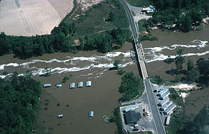
, crossing the Apalachicola River
on the Trammell Bridge
, then proceeding though the Apalachicola National Forest
and Tallahassee. It then becomes a hidden route briefly along US 90 in Tallahassee, then along US 27 in Tallahassee where it joins the Apalachee Parkway, a major east-west thoroughfare in the city. Constructed in 1957, the Apalachee Parkway starts at Monroe Street
in front of the Florida State Capitol
building. It has a short expressway section just east of the capitol, then is a busy four-lane surface boulevard with service roads for the next few miles, passing the Governor's Square Mall
and many state office buildings.After the Parkway ends, SR 20 remains a hidden route along US 27 as they run through Capps, Florida
, where US 19
joins US 27 until they reach Perry
where US 19 continues south towards the Tampa Bay Metropolitan Area, while US 27-SR 20 run east to High Springs
.
After a brief signed portion in High Springs, State Road 20 is again hidden along US 441 to Gainesville
, where it becomes a stand-alone route along Northwest 6th Street, then turns east onto Northwest 8th Avenue, until running south again onto North Main Street before it overlaps such roads as SR 24 and 26. East of Gainesville, the road again becomes a stand-alone route that is four lanes wide as it runs through Lochloosa Wildlife Conservation Area to the interchange with US 301
in Hawthorne
. The road has since been widened along the route between Interlachen
and Francis as it heads into Palatka
, finally (and, again, "secretly") joining
with State Road 100
to a terminus at US 1 in Bunnell
.
 Liberty County Road 120 (CR 120) is a short piece of an old alignment of State Road 20, at the Liberty
/Leon County
Line. CR 120 only extends a couple of tenths of a mile (about 300 m) to the Ochlockonee River
, where the old bridge has been dismantled; thus, it no longer connects, to Leon County CR 20, on the other side of the river.
The main reasons for a realignment were to straighten out the curve on the Leon County side and to bypass a residential area. Along CR 120, are entrances to a couple of residences and an abandoned gas station.
Florida Panhandle
The Florida Panhandle, an informal, unofficial term for the northwestern part of Florida, is a strip of land roughly 200 miles long and 50 to 100 miles wide , lying between Alabama on the north and the west, Georgia also on the north, and the Gulf of Mexico to the south. Its eastern boundary is...
.
Route description
The western terminus of State Road 20 is at State Road 85 in NicevilleNiceville, Florida
Niceville is a city in Okaloosa County, Florida, United States, located close to Eglin Air Force Base. It originally began with the name Valparaiso, then to separate itself from the neighboring town took the unofficial name of Boggy. Upon incorporation as an official city, the name was changed to...
. The route proceeds east through Blountstown
Blountstown, Florida
Blountstown is a city in Calhoun County, Florida, United States. The population was 2,444 at the 2000 census. According to the U.S Census estimates of 2005, the city had a population of 2,433...
, crossing the Apalachicola River
Apalachicola River
The Apalachicola River is a river, approximately 112 mi long in the State of Florida. This river's large watershed, known as the ACF River Basin for short, drains an area of approximately into the Gulf of Mexico. The distance to its farthest headstream in northeast Georgia is approximately 500...
on the Trammell Bridge
Trammell Bridge
The Trammell Bridge is 1.6 miles long and carries State Road 20 over the Apalachicola River in the Florida Panhandle between Blountstown and Bristol...
, then proceeding though the Apalachicola National Forest
Apalachicola National Forest
The Apalachicola National Forest is the largest U.S. National Forest in the state of Florida. It contains and is the only national forest located in the Florida Panhandle. The Apalachicola National Forest contains two Wilderness Areas, Bradwell Bay and Mudswamp/New River...
and Tallahassee. It then becomes a hidden route briefly along US 90 in Tallahassee, then along US 27 in Tallahassee where it joins the Apalachee Parkway, a major east-west thoroughfare in the city. Constructed in 1957, the Apalachee Parkway starts at Monroe Street
State Road 61 (Florida)
State Road 61 is located in the Big Bend area of Florida, running through the state capital of Tallahassee.-Route description:SR 61 begins at US 98 as an unsigned route, heading north on US 319, until it splits off with the highway in Crawfordville and becomes Wakulla County Road 61...
in front of the Florida State Capitol
Florida State Capitol
The Florida State Capitol, in Tallahassee, Florida, USA, is the state capitol of the U.S. state of Florida. The building is an architecturally and historically significant building, having been listed on the National Register of Historic Places....
building. It has a short expressway section just east of the capitol, then is a busy four-lane surface boulevard with service roads for the next few miles, passing the Governor's Square Mall
Governor's Square
Governor's Square is a super-regional shopping mall located on Apalachee Parkway in Tallahassee, Florida. Its two-level design was a first for northern Florida when it opened in 1979, and it remains the newest of two enclosed malls in the Tallahassee area, the other being Tallahassee Mall. Its...
and many state office buildings.After the Parkway ends, SR 20 remains a hidden route along US 27 as they run through Capps, Florida
Capps, Florida
Capps is an unincorporated community in Jefferson County, Florida, United States. It is located at the intersection of US 19 and US 27. During the 1940's and 50's, Capps was the headquarters of an agri-business known as Tungston Plantation, owned by Everett P. Larsh, an industrialist from Dayton,...
, where US 19
U.S. Route 19 in Florida
U.S. Route 19 in Florida runs along Florida's west coast from an interchange with U.S. Route 41 in Memphis, Florida, south of Tampa, and continues to the Georgia border north of Monticello, Florida....
joins US 27 until they reach Perry
Perry, Florida
Perry is a city in Taylor County, Florida, United States. The population was 7,017 at the 2010 census. As of 2010, the population recorded by the U.S. Census Bureau is 7,017....
where US 19 continues south towards the Tampa Bay Metropolitan Area, while US 27-SR 20 run east to High Springs
High Springs, Florida
High Springs is a city in Alachua County, Florida, United States. The population was 3,863 at the 2000 census. As of 2004, the population recorded by the U.S. Census Bureau is 4,139 .-Geography:High Springs is located at ....
.
After a brief signed portion in High Springs, State Road 20 is again hidden along US 441 to Gainesville
Gainesville, Florida
Gainesville is the largest city in, and the county seat of, Alachua County, Florida, United States as well as the principal city of the Gainesville, Florida Metropolitan Statistical Area . The preliminary 2010 Census population count for Gainesville is 124,354. Gainesville is home to the sixth...
, where it becomes a stand-alone route along Northwest 6th Street, then turns east onto Northwest 8th Avenue, until running south again onto North Main Street before it overlaps such roads as SR 24 and 26. East of Gainesville, the road again becomes a stand-alone route that is four lanes wide as it runs through Lochloosa Wildlife Conservation Area to the interchange with US 301
U.S. Route 301 in Florida
U.S. Route 301 in Florida runs from the Sarasota-Bradenton-Venice, Florida Metropolitan Statistical Area northeast to the Greater Jacksonville Metropolitan Area. The road is a spur of U.S...
in Hawthorne
Hawthorne, Florida
Hawthorne is a city in Alachua County, Florida, United States. The population was 1,417 at the 2010 census.-Geography:Hawthorne is located at .According to the United States Census Bureau, the city has a total area of...
. The road has since been widened along the route between Interlachen
Interlachen, Florida
Interlachen is a town in Putnam County, Florida, United States. The population was 1,475 at the 2000 census. The town is part of the Palatka Micropolitan Statistical Area.-Geography:Interlachen is located at ....
and Francis as it heads into Palatka
Palatka, Florida
Palatka is a city in Putnam County, Florida, United States. The population was 10,033 at the 2000 census. As of 2004, the population recorded by the U.S. Census Bureau is 10,796. It is the county seat of Putnam County and includes East Palatka. Palatka is the principal city of the Palatka...
, finally (and, again, "secretly") joining
Concurrency (road)
A concurrency, overlap, or coincidence in a road network is an instance of one physical road bearing two or more different highway, motorway, or other route numbers...
with State Road 100
State Road 100 (Florida)
State Road 100 is a 151-mile-long northwest-southeast highway serving northeastern Florida. Its northwestern terminus is at the Georgia-Florida border four miles north of Avoca, Florida ; its southeastern terminus is an intersection with Shore Scenic Highway in Flagler Beach...
to a terminus at US 1 in Bunnell
Bunnell, Florida
Bunnell is the county seat of Flagler County Florida with a population of 2,122 at the 2000 census. According to the U.S Census estimates of 2008, the city's population had grown to 3,190. The city is part of the Palm Coast Metropolitan Statistical Area and is named after early resident, Alvah A...
.
Related route
Liberty County, Florida
Liberty County is a county located in the state of Florida. Its population was estimated in 2005 as 7,733. Its most populous incorporated area and county seat is Bristol....
/Leon County
Leon County, Florida
Leon County is a county located in the state of Florida, named after the Spanish explorer Juan Ponce de León. At the 2010 Census, the population was 275,487. The county seat of Leon County is Tallahassee which also serves as the state capital. The county seat is home to two of Florida's major...
Line. CR 120 only extends a couple of tenths of a mile (about 300 m) to the Ochlockonee River
Ochlockonee River
The Ochlockonee River is a fast running river originating in Georgia and flowing for before terminating in Florida.- Background :The Ochlockonee originates south of the town of Sylvester in Worth County in southwest Georgia emptying into Ochlockonee Bay, then into Apalachee Bay, in Florida...
, where the old bridge has been dismantled; thus, it no longer connects, to Leon County CR 20, on the other side of the river.
The main reasons for a realignment were to straighten out the curve on the Leon County side and to bypass a residential area. Along CR 120, are entrances to a couple of residences and an abandoned gas station.