

Tyldesley
Encyclopedia
Tyldesley is a town within the Metropolitan Borough of Wigan
, in Greater Manchester
, England. It occupies an area north of Chat Moss
near the foothills of the West Pennine Moors
, 7.7 miles (12.4 km) east-southeast of Wigan
and 8.9 miles (14.3 km) west-northwest of the city of Manchester
. At the time of the United Kingdom Census 2001
, Tyldesley, which includes the outlying areas of Astley
, Shakerley
, Mosley Common
and New Manchester
, had a population of 34,000.
Historically
a part of Lancashire
, Tyldesley and its surroundings have provided evidence for the remains of a Roman road
passing through the area on the ancient course between Coccium (Wigan) and Mamucium (Manchester). Following the Anglo-Saxon invasion of Britain, Tyldesley was part of the manor of Warrington
, until the Norman conquest of England
, when Tyldesley constituted a township
by the name of Tyldesley-with-Shakerley in the ancient parish of Leigh
.
The factory system
, and textile manufacture during the Industrial Revolution
, triggered a process of population growth and unplanned urbanisation in the area, such that by the early 20th century it was said that the newly emerged mill town
was "eminently characteristic of an industrial district whose natural features have been almost entirely swept away to give place to factories, iron foundries, and collieries". Although industrial activity declined in the late 20th century, land reclamation
and post-war
residential developments have continued to alter Tyldesley's landscape, and have encouraged renewed economic activity, particularly along Elliott Street—Tyldesley's central commercial area and its main thoroughfare.
(OE) personal name
Tilwald (or Tīlwald) and leăh meaning wood or clearing, suggesting that what is now open land was once covered with forest. The name was recorded as Tildesleiha in about 1210. Alternative spellings include Tildeslei, Tildeslege, Tildeslegh, and Tildesley. The town is situated at the edge of the Lancashire Plain north of Chat Moss
. The sandstone ridge where the foothills of the Pennines begin gave the town its early name of Tildesley Banks. Banks refers to the hill upon which the town was established and is locally known as "Bongs". In local pronunciation "Banks" became corrupted to "Bongs". The old name for Mosley Common was the "Hurst" or "Tyldesleyhurst", the suffix hyrst meaning a wooded hill (OE).
which ran through the township, serving the camps at Coccium (Wigan
) and Mamucium (Manchester
). The road ran from Keeper Delph in Boothstown
, north west, crossing Mort Lane, and between Cleworth Hall and Shakerley Old Hall which were sited closer to the Roman road than the present main road.
It continued towards the Valley at Atherton where coins have been found, on towards Gibfield and hence towards Wigan. In 1947 two urns containing about 550 Roman bronze coins, minted between AD 259 and AD 278, were found near the route of the ancient Roman road at Keeper Delph in Boothstown, near the old Tyldesley–Worsley border. These coins are in the British Museum
.
After the Roman departure from Britain, and into the history of Anglo-Saxon England
, nothing was written about Tyldesley. Evidence for the presence of Saxons
in what was a sparsely populated and isolated part of the country is provided by local place names that incorporate the Old English suffix of leah, such as Tyldesley, Shakerley, and Astley.
was Astley Hall or Damhouse
, in 1212 the home of Hugh Tyldesley, Lord of the Manors of Astley and Tyldesley. The hall is just inside the Tyldesley boundary but has been associated with Astley since the death of Henry Tyldesley in 1301, when the manor was divided between three of his sons. The Tyldesleys "were a family who gained a reputation for lawlessness and who had frequent disputes with their neighbours". One notable exception was Hugh Tyldesley or Hugh the Pious, who before his death in 1226 endowed Cockersand Abbey
in North Lancashire, granting it the lands of Shakerley
.
The new manor became known as the Garrett or Garrett Hall and in 1505 was in the possession of John Tyldesley. Garrett Hall, a timber-framed structure, was first recorded in 1505 and remained in the Tyldesley family until 1652 when Lambert Tyldesley died leaving no heir. The new owners, the Stanleys, lived elsewhere and the hall was leased to tenants. In 1732 the hall was sold to Thomas Clowes who continued leasing the property. In 1829 the hall became part of the Bridgewater Estates. Generations of Shakerleys lived in the hamlet of the same name at Shakerley Old Hall, close to the Shakerley Brook and the Roman road from Manchester to Wigan. They paid rent to Cockersand Abbey and dues of "one pair of white gloves at the feast of Easter" to Adam Tyldesley.
Chaddock Hall was home to a family of yeomen farmers with the same name. It was mentioned in Lancashire Assizes Rolls in 1246 when the name was spelt Chaydok, Lancashire Inquests from 1323 referred to Chaidoke and the Lancashire Lay Subsidy Roll
in 1332 mentioned Chaidok. The last syllable probably is "oak". The hall was central to a small hamlet in the east of the township. The Chaddocks, like the Tyldesleys and the Shakerleys, had a reputation for lawlessness.
Cleworth Hall, Cluworth in 1333, an estate of 163 acre (0.65963818 km²) on high ground near the centre of the township not far from the high road, was originally part of the Tyldesley lands. In 1578 it passed to Nicholas Starkie by marriage to Anne Parr and during his ownership, in 1594, became associated with witchcraft
. Two children, John and Anne Starkie became "possessed of evil spirits". A well known "conjurer" or wise man, Edmund Hartley, who was in the area was asked to cure the children which he apparently did. Hartley demanded money but was refused and he threatened trouble. Starkie denounced him and he was taken for trial at Lancaster Assizes in 1597 where he was tried and found guilty of witchcraft. Hartley was hanged
twice, as the rope broke at the first attempt.
The tenants of the Tyldesley, Shakerley and Chaddock lands were often summoned to do military service. Archer
s from Chaddock fought at Crécy in 1346 and at the Battle of Agincourt
in 1415. In 1360 William Chaddock was an archer on foot, "potens de corpore et bonis", or fit for active service in both body and accoutrements. A later muster roll shows Hugh Tyldesley to be an archer on horseback. Hugh Chaddock and Richard Tyldesley were both foot-archers serving under Herford. They drew daily pay for service from 22 July to 21 October 1391.
Chaddock Hall and Dam House survive, the former as a private residence and Dam House as a Heritage Centre having previously been used as the office block for Astley Hospital. Chaddock Hall is a Grade II Listed building, as is Damhouse.
of the present town is from this date.
John Aikin
described the area in 1795 in his book A Description of the Countryside from 30 to 40 Miles around Manchester:
The Flaming Castle later the Castle Inn in Castle Street, was Tyldesley's first inn and dates from 1778. The Green Dragon, now the George, dates from 1781 but was rebuilt in 1904. Fullwell House built in 1792 was a substantial property in Squires Lane occupied by mill owners. It was demolished in 1935. At the end of the 18th century rows of two-storey brick terraced houses were built at the west end of the town to house the workers who had migrated to Tyldesley to work in the new factories.
 Until the Industrial Revolution
, Tyldesley was broadly rural
with scattered communities concentrated around the old manor halls. Agriculture and a cottage spinning and weaving industry, mainly muslin
and fustian
, were the chief occupations before 1800. Silk
weaving became an important cottage industry in the Leigh, Astley and Tyldesley area after 1827 when silk was brought from Manchester.
In 1772 Thomas Johnson opened his "Little Factory" for carding
and spinning cotton
. He opened "The Great Leviathon", a steam driven mill on Factory Street, for woollen spinning in 1792 but this quickly became a cotton mill
. More cotton mills were built close to the Hindsford and Shakerley Brooks which provided them with water. New Mills was a complex owned by Messrs. J & G Jones around Factory Street where in 1823, after a strike for increased wages and lockout by the millowners, all the workers were sacked and new hands hired to replace them. These "scab" labourers were known as "knobsticks" and armed police had to be brought in to protect them from assault by the dismissed labour force. Joseph Wilson built Hope Mill in James Street. By 1838 James Burton owned most of the mills in the town. He lived in Charles Street surrounded by his workforce. His company owned 74 cottages and 57 cellars, a house in Elliot Street and the King's Arms public house. He died in 1868. In 1883 a fire at Burton's Mills caused £15,000 damage (£ as of ) and by 1920 all his mills were demolished.
Tyldesley's most famous millowner was Caleb Wright
, owner of the Barnfield Mills with a workforce of about 800. The last of his mills, Barnfield No6 on Shuttle Street, was built in about 1894 on the site of Resolution Mill which was destroyed by fire in 1891. It was a concrete-floored multi-storey block for spinning, powered by an external engine house via a rope race. It was demolished in the 1990s, and the site is now occupied by a supermarket.
Coal had been got in Shakerley
in the 15th century. There is a record of a dispute between the Shakerleys and the Tyldesleys over the stealing of "seacoals" in 1429. Shakerley Colliery was in existence in 1798. Shakerley along with neighbouring Chowbent, in Atherton
was a centre for making nails, but was in decline by 1800. After 1800 Tyldesley grew to prominence, like many of its neighbours, through the coal
and cotton industries.
After the building of the Tyldesley Loopline
in 1864 coal mining
became the dominant industry in Tyldesley which was surrounded by collieries for over 100 years until coal's decline after the Second World War. The Bridgewater Collieries
, Tyldesley Coal Company
, Shakerley Collieries
and Astley and Tyldesley Collieries
were among the local mine owners. Gin Pit closed in 1955, Cleworth in 1963, Nook two years later in 1965, and Mosley Common in 1968. Tyldesley Miners Association, established in 1862, opened the Tyldesley Miner's Hall on Elliot Street in 1893 and the Astley and Tyldesley Miner's Club opened at Gin Pit in 1927 and remains open.
Another important employer in Tyldesley was Grundy's Foundry. Its founder was John Grundy, a local shop keeper. His idea was a warm air heating system to heat churches and halls. He built a foundry close to the railway in Lower Elliot Street.
Land reclamation
and new housing developments have changed the face of the town's outlying areas, but the centre still retains the atmosphere of a bustling market town, with a refurbished market square
. The steep terraces branching off the main streets give the town a distinctive character.
 Tyldesley forms an electoral ward of the Metropolitan Borough of Wigan
. The ward elects three councillors to the 75-member metropolitan borough council, Wigan's local authority. As of 2009, the three ward councillors of Tyldesley are members of the Liberal Democrats. They form part of the opposition Democratic Alliance grouping on the Labour
controlled council.
Historically, Tyldesley formed part of the Hundred of West Derby
, a judicial division of southwest Lancashire. Tyldesley cum Shakerley was one of the six townships or vills that made up the ancient parish of Leigh. The townships existed before the parish. Tyldesley cum Shakerley was the largest of the six townships in the parish at 2610 acres (10.6 km²): Tyldesley having an area of 1970 acres (8 km²) and Shakerley 520 acres (2.1 km²). The manor
of Tyldesley was held by the de Tyldesley family from the de Botelers, whose chief manor was at Warrington
.
Under the terms of the Poor Law Amendment Act 1834
the townships formed part of the Leigh Poor Law Union
which was established on 26 January 1837 comprising an area covering the whole of the ancient parish of Leigh and part of Winwick. There were workhouse
s in existence in Pennington, Culcheth, Tyldesley and Lowton, but Leigh Union workhouse
at Atherleigh replaced these in the 1850s. In 1866 Tyldesley was constituted a separate civil parish
. In 1863 the Local Government Act 1858 was adopted for the township of Tyldesley-with-Shakerley, meaning it was governed by a local board of health
, a type of regulatory body responsible for standards of hygiene and sanitation in the township. The first Tyldesley Local Board of Health was formed after elections on 24 October 1863. Of those elected were local industrialists—Caleb Wright and Oliver Burton, mill owners, William Ramsden and George Green, colliery owners. They were a mixture of Tories
and Liberals
. The local board took over the gas works in 1865, in 1876 built the first swimming baths, opened Tyldesley Cemetery in Hough Lane in 1876 and built sewage works at Morley's Hall in Astley in 1884. The offices of the local board were in Lower Elliot Street, where the council also had a fire station and depot. Under the Public Health Act 1875
the local board gained additional duties and powers as an urban sanitary district
and under the Local Government Act 1894
Tyldesley-with-Shakerley became an urban district
of the administrative county
of Lancashire, with an elected urban district council (UDC). What became Tyldesley Town Hall was originally the township's Liberal Club, opened in 1881, and was taken over by Tyldesley Urban District
Council as its headquarters in 1924. Actions of Tyldesley UDC included the opening of Tyldesley Park on Astley Street in 1902, the provision of the Carnegie Library
in 1909, and council housing estates at Sale Lane, Mosley Common and Shakerley.
In 1933, Lancashire County Council
conducted a review of its political structure resulting in a reorganisation of districts in the county, with reference to the Local Government Act 1929
. A new Tyldesley Urban District was formed by the amalgamation of Tyldesley with Shakerley Urban District and the parish of Astley
from the abolished Leigh Rural District
. The urban district was abolished in 1974 under the Local Government Act 1972
, when the area became part of the Metropolitan Borough of Wigan, a local government district of the metropolitan county
of Greater Manchester
.
Following a review of parliamentary representation in Greater Manchester, the Boundary Commission recommended that Tyldesley should be part of the Leigh
constituency at the next general election. At the 2010 General Election Andy Burnham retained the Leigh seat for the Labour party
with 24,295 votes and a majority of 15,011, representing 51.3% of the vote. The Conservatives
took 19.6% of the vote, the Liberal Democrats
17.0%, the UKIP
3.2%, the BNP
5.8%, the Christian Party 0.3% and Independents 2.8%.
, Tyldesley is situated 7.7 miles (12.4 km) east-southeast of Wigan and 8.9 miles (14.3 km) west-northwest of the city of Manchester, and at the eastern end of the Metropolitan Borough of Wigan. Topographically, Tyldesley is situated at the edge of the Lancashire Plain just to the north of Chat Moss
and the Banks of Tyldesley are where the foothills of the Pennines begin. The land rises from about 100 ft (30.5 m) at the foot of the banks to 250 ft (76.2 m) at the highest point. The banks are about one and a half miles long, they are a sandstone
escarpment with the scarp slope facing south with the gentler dip to the north. The underlying rocks are largely the coal measures
of the Manchester Coalfield
covered with boulder clay. Streams drain the area including the Shakerley and Hindsford brooks
which flow in to Glaze Brook
a tributary of the River Mersey
. Heavily industrialised during the 19th century, Tyldesley has become a residential area since the demise of the coal industry and closure of the cotton mills. The main road through Tyldesley is the A577 which runs along the ridge on which the town centre is situated.
As of the 2001 UK census
, Tyldesley had a population of 34,022. The 2001 population density was 13789 PD/sqmi, with a 100 to 97.4 female-to-male ratio. Of those over 16 years old, 27.3% were single (never married), 47.8% married and 8.2% divorced. Although the proportion of divorced people was similar to that of Wigan and England, the rates of those who were single and married were significantly different to the national and Wigan averages (Wigan: 42.4% single, 36.6% married; England: 44.3% single, 34.7% married). Tyldesley's 13,621 households included 24.0% one-person, 46.1% married couples living together, 10.2% were co-habiting
couples, and 9.0% single parents with their children. Of those aged 16–74, 27.0% had no academic qualifications, lower than 28.9% in all of England and much lower than the 35.3% for the Wigan borough.
According to the United Kingdom Census 2001
, the industry of employment of residents aged 16–74 was 18.1% retail and wholesale, 16.5% manufacturing, 12.1% property and business services, 10.9% health and social work, 7.4% education, 7.1% transport and communications, 7.6% construction, 5.8% public administration, 5.0% finance, 4.1% hotels and restaurants, 0.8% energy and water supply, 0.5% agriculture, 0.1% mining, and 4.2% other. Compared with national figures, the town had a relatively low percentage working in agriculture. The census recorded the economic activity of residents aged 16–74, 2.6% students were with jobs, 3.2% students without jobs, 4.7% looking after home or family, 6.7% permanently sick or disabled, and 2.1% economically inactive for other reasons.
The main concentrations of employment are at Chaddock Lane between Astley and Mosley Common and at Parr Brow to the north of Mosley Common.
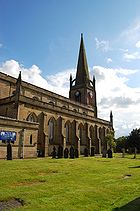 For many years Tyldesley's landscape was dominated by its factory chimneys and pit headgear. Since the closure of the mines and demolition of the factories, St George's Parish Church
—one of the few structures in the town built of stone, with a spire rising to
150 feet (45.7 m) in height—and Top Chapel
in the Market Square have become the chief landmarks; both are Grade II listed buildings. Tyldesley's built environment is almost uniformly constructed of brick.
, the driver of the first inter-city scheduled passenger train in the world, was born in Tyldesley in 1815. He drove the passenger service on the Liverpool to Manchester railway
.
In 1861 the London and North Western Railway
revived powers granted to the Lancashire and Yorkshire Railway
to build a railway from Eccles
to Wigan through Tyldesley. Tyldesley railway station
was to the east of the junction of the branch to Kenyon Junction
on the Liverpool to Manchester Line via Leigh and Pennington. The Earl of Ellesmere cut the first sod at Worsley on 11 September 1861 and the line opened to traffic on 1 September 1864. The Tyldesley Loopline
closed on 3 May 1969 as a result of the Beeching Axe
. The former trackbed within the Wigan MBC area was reserved, in case the rail route could be reinstated, in the Unitary Development Plan, UDP. The current proposal for the Leigh-Tyldesley area is a guided bus
route along the trackbed joining the A580
close to Roe Green
but this not universally popular.
The nearest railway station is Atherton which is 1.2 miles (1.9 km) to the north on the Wigan to Manchester line.
In 1900, a Bill authorising the South Lancashire Tramways
Company to construct over 62 miles (99.8 km) of tramway in southern Lancashire was given Royal Assent. However, by November 1900 the South Lancashire Electric Traction and Power Company had acquired the shares. The first section of tramway opened on 20 October 1902 between Lowton
and Four Lanes Ends via Leigh and Atherton and on 25 October 1902 a branch from Atherton to Tyldesley was opened and Tyldesley got its first tram. This company got into financial difficulty and in turn became Lancashire United Tramways later Lancashire United Transport
. In August 1931 trams were replaced by trolley buses. Because of Tyldesley's narrow streets trams, and later trolley buses, followed a one-way system; eastbound trams ran along Shuttle Street and Milk Street and westbound trams used Elliot Street and Castle Street, a system now used by all traffic. Tyldesley is connected to neighbouring towns by bus services operated by South Lancs Travel
of Atherton and First Manchester
.
 George Ormerod
gave a site for a school to the west of St George's Church and subscriptions paid for the building, a national school
which opened in 1827. St George's School had separate boys and girls departments, it catered for all age groups. A day school was opened in the old Wesley Chapel in 1856 and in 1864 a new school built which lasted until 1912. A school opened in Johnson St in 1872. This lasted as an infant school into the 1960s. The building still stands. Garrett Hall Boys Secondary School opened in 1935. It is now the site of Garrett Hall Primary School.
The main school for secondary education
in Tyldesley is Fred Longworth High School,
which was awarded Arts College
status in 1998. Children in Tyldesley also attend other high
schools in the area including Hesketh Fletcher CE High School in Atherton, St Mary's RC High
School in Astley, the only Catholic high school and sixth form in the area and Bedford High School, Leigh.
St George's Central Primary School, is an amalgamation in the late 1990s of the historical St George's
Cof E and Central C of E Schools. Central C of E School in Darlington Street was sometimes
referred to as the "Mission School". Other primary schools in Tyldesley are Tyldesley Primary School and Garrett Hall Primary.
Until recently there was a school in Shakerley but this has now closed. Children of primary age in Tyldesley attend schools
in Astley, Boothstown, Mosley Common and Hindsford, Atherton.
Kingshill School in Lower Elliot St was a special school but has recently closed.
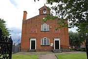 Tyldesley's first place of worship, Top Chapel
was built in the Square in 1789 for the Countess of Huntingdon's sect which had broken away from the Church of England
.
John Wesley
had preached in Shakerley
laying the foundations for a place of worship in the area. In the 1780s George Whitfield who had worked with John Wesley earlier on in his ministry, preached in Shakerley. The local squire, Thomas Johnson, gifted land on the highest point of Tyldesley for a chapel and Lady Huntingdon, a supporter of John Wesley supplied money for the building materials. The chapel was completed in 1789 and became known as the Top Chapel due to its geographical location. The chapel has its own graveyard.
Before 1825 Tyldesley had no church, and for ecclesiastical purposes, lay within the ancient parish of Leigh in the Diocese of Chester
. This diocese divided in 1847, when the present Diocese of Manchester
was created. For ritual baptism
s, marriage
s and burial
s, the people of Tyldesley, had to travel to churches that lay outside of the township's boundaries, including Leigh Parish Church or its daughter churches, Astley St Stephen's or Atherton, St John the Baptist or to Deane Parish Church or Eccles Parish Church.
The Parish Church of St George, Tyldesley
a chapel of ease
to the mother church of Leigh, St Mary's, was built in 1825 on land donated by Thomas Johnson. It was a Waterloo church, paid for by money from the parliament of the United Kingdom
raised by the Church Building Act 1818, and said to be a celebration of Britain's victory in the Battle of Waterloo
. Robert Smirke
was an official architect to the Office of Works
and advised the Parliamentary Commissioners on the building of new churches from 1818 onwards, including St George, Tyldesley. The chapel was consecrated on 19 September 1825, dedicated to Saint George
. The church could seat 1,100 people, it is 112 feet (34 m) in length, 60 feet (18 m) in width and its spire, a local landmark is 150 feet (46 m) in height. George Ormerod gave the land for the churchyard and also six bells which were cast at Downham Market
, in Norfolk
.
There were chapels of the Congregational, Primitive Methodist, Wesleyan Methodist, Baptist, Welsh Congregational, Welsh Calvinistic, and Independent Methodist connexions. The Welsh chapels served the Welsh people who migrated to Tyldesley after the opening of the railway in 1864.
. The Local Board built Tyldesley Baths in Union Street at a cost of £1,300 (£ as of ) and they opened to great celebrations in 1876. Tyldesley Swimming Club was formed as soon as the Baths opened. The Union Street Baths closed on health grounds in 1960 and the old Majestic Cinema on Castle Street was converted into the present public baths in 1964.
Before the 1895 schism in English rugby, John Berry
played rugby union for England
, and Tyldesley FC, which was founded in 1881. After the schism, the club was a founder member of the Northern Rugby Football Union (now Rugby Football League
) and played for five seasons from 1895–96 to 1899–1900 finishing 6th of 22 in the initial combined league. It rejoined the Rugby Football Union
(Rugby Union) in 1911 and played at Well Street for many years before moving to St George's Park, Astley Street in November 2001. In the 2008/09 season the club lost 8-7 to Cullompton (Devon) in the Senior Vase Final at Twickenham.
A public library was opened in 1908 with the aid of an Andrew Carnegie
Grant, on the site of the old Temperance Hall and Mechanics Institute on Stanley Street.
Founded in 1877, Tyldesley Good Templars Band was the town's first Brass Band. Tyldesley
Band today is a member of the North West Brass Band Association and meets
in the chapel building on Milk Street. Tyldesley Little Theatre
in Lemon Street is home to an amateur dramatic society, members of the Greater Manchester Drama Federation. The auditorium is a small 150-seat theatre with a traditional proscenium arch stage, stalls and balcony seating.
Metropolitan Borough of Wigan
The Metropolitan Borough of Wigan is a metropolitan borough of Greater Manchester, in North West England. It is named after its largest component town, Wigan and also includes the towns of Leigh, Ashton-in-Makerfield, Ince-in-Makerfield, and Hindley. The borough was formed in 1974 and is an...
, in Greater Manchester
Greater Manchester
Greater Manchester is a metropolitan county in North West England, with a population of 2.6 million. It encompasses one of the largest metropolitan areas in the United Kingdom and comprises ten metropolitan boroughs: Bolton, Bury, Oldham, Rochdale, Stockport, Tameside, Trafford, Wigan, and the...
, England. It occupies an area north of Chat Moss
Chat Moss
Chat Moss is a large area of peat bog that makes up 30 percent of the City of Salford, in Greater Manchester, England. It is north of the River Irwell, to the west of Manchester, and occupies an area of about...
near the foothills of the West Pennine Moors
West Pennine Moors
The West Pennine Moors cover an area of approximately of moorland and reservoirs in Lancashire and Greater Manchester, England.The West Pennine Moors are separated from the main Pennine range by the Irwell Valley. The moorland includes Withnell, Anglezarke and Rivington Moors in the extreme west,...
, 7.7 miles (12.4 km) east-southeast of Wigan
Wigan
Wigan is a town in Greater Manchester, England. It stands on the River Douglas, south-west of Bolton, north of Warrington and west-northwest of Manchester. Wigan is the largest settlement in the Metropolitan Borough of Wigan and is its administrative centre. The town of Wigan had a total...
and 8.9 miles (14.3 km) west-northwest of the city of Manchester
Manchester
Manchester is a city and metropolitan borough in Greater Manchester, England. According to the Office for National Statistics, the 2010 mid-year population estimate for Manchester was 498,800. Manchester lies within one of the UK's largest metropolitan areas, the metropolitan county of Greater...
. At the time of the United Kingdom Census 2001
United Kingdom Census 2001
A nationwide census, known as Census 2001, was conducted in the United Kingdom on Sunday, 29 April 2001. This was the 20th UK Census and recorded a resident population of 58,789,194....
, Tyldesley, which includes the outlying areas of Astley
Astley, Greater Manchester
Astley is a settlement within the Metropolitan Borough of Wigan in Greater Manchester, England, variously described as a suburb or a village. Astley lies on flat land to the northwest of the city of Manchester, and is crossed by the Bridgewater Canal and the A580 "East Lancashire Road"...
, Shakerley
Shakerley
Shakerley is a suburb of Tyldesley in the Metropolitan Borough of Wigan, Greater Manchester, England.It was anciently a hamlet in the northwest of the township of Tyldesley cum Shakerley, in the ancient parish ofLeigh....
, Mosley Common
Mosley Common
Mosley Common is a suburb of Tyldesley at the far-eastern edge of the Metropolitan Borough of Wigan, in Greater Manchester, England.It was anciently a hamlet in the east of the township of Tyldesley cum Shakerley, in the ancient parish of Leigh...
and New Manchester
New Manchester
New Manchester or The City was an isolated mining village on the Manchester Coalfield north of Mosley Common in the Tyldesley township. It lies west of a boundary stone at Ellenbrook which marks the ancient boundary of the Hundreds of Salford and West Derby, the boundary of Eccles and Leigh...
, had a population of 34,000.
Historically
Historic counties of England
The historic counties of England are subdivisions of England established for administration by the Normans and in most cases based on earlier Anglo-Saxon kingdoms and shires...
a part of Lancashire
Lancashire
Lancashire is a non-metropolitan county of historic origin in the North West of England. It takes its name from the city of Lancaster, and is sometimes known as the County of Lancaster. Although Lancaster is still considered to be the county town, Lancashire County Council is based in Preston...
, Tyldesley and its surroundings have provided evidence for the remains of a Roman road
Roman road
The Roman roads were a vital part of the development of the Roman state, from about 500 BC through the expansion during the Roman Republic and the Roman Empire. Roman roads enabled the Romans to move armies and trade goods and to communicate. The Roman road system spanned more than 400,000 km...
passing through the area on the ancient course between Coccium (Wigan) and Mamucium (Manchester). Following the Anglo-Saxon invasion of Britain, Tyldesley was part of the manor of Warrington
Warrington
Warrington is a town, borough and unitary authority area of Cheshire, England. It stands on the banks of the River Mersey, which is tidal to the west of the weir at Howley. It lies 16 miles east of Liverpool, 19 miles west of Manchester and 8 miles south of St Helens...
, until the Norman conquest of England
Norman conquest of England
The Norman conquest of England began on 28 September 1066 with the invasion of England by William, Duke of Normandy. William became known as William the Conqueror after his victory at the Battle of Hastings on 14 October 1066, defeating King Harold II of England...
, when Tyldesley constituted a township
Township (England)
In England, a township is a local division or district of a large parish containing a village or small town usually having its own church...
by the name of Tyldesley-with-Shakerley in the ancient parish of Leigh
Leigh, Greater Manchester
Leigh is a town within the Metropolitan Borough of Wigan, in Greater Manchester, England. It is southeast of Wigan, and west of Manchester. Leigh is situated on low lying land to the north west of Chat Moss....
.
The factory system
Factory system
The factory system was a method of manufacturing first adopted in England at the beginning of the Industrial Revolution in the 1750s and later spread abroad. Fundamentally, each worker created a separate part of the total assembly of a product, thus increasing the efficiency of factories. Workers,...
, and textile manufacture during the Industrial Revolution
Textile manufacture during the Industrial Revolution
The industrial revolution changed the nature of work and society. Opinion varies as to the exact date, but it is estimated that the First Industrial Revolution took place between 1750 and 1850, and the second phase or Second Industrial Revolution between 1860 and 1900. The three key drivers in...
, triggered a process of population growth and unplanned urbanisation in the area, such that by the early 20th century it was said that the newly emerged mill town
Mill town
A mill town, also known as factory town or mill village, is typically a settlement that developed around one or more mills or factories .- United Kingdom:...
was "eminently characteristic of an industrial district whose natural features have been almost entirely swept away to give place to factories, iron foundries, and collieries". Although industrial activity declined in the late 20th century, land reclamation
Land reclamation
Land reclamation, usually known as reclamation, is the process to create new land from sea or riverbeds. The land reclaimed is known as reclamation ground or landfill.- Habitation :...
and post-war
Post-war
A post-war period or postwar period is the interval immediately following the ending of a war and enduring as long as war does not resume. A post-war period can become an interwar period or interbellum when a war between the same parties resumes at a later date...
residential developments have continued to alter Tyldesley's landscape, and have encouraged renewed economic activity, particularly along Elliott Street—Tyldesley's central commercial area and its main thoroughfare.
Toponymy
Tyldesley meaning "Tilwald's clearing" is derived from the Old EnglishOld English language
Old English or Anglo-Saxon is an early form of the English language that was spoken and written by the Anglo-Saxons and their descendants in parts of what are now England and southeastern Scotland between at least the mid-5th century and the mid-12th century...
(OE) personal name
Personal name
A personal name is the proper name identifying an individual person, and today usually comprises a given name bestowed at birth or at a young age plus a surname. It is nearly universal for a human to have a name; except in rare cases, for example feral children growing up in isolation, or infants...
Tilwald (or Tīlwald) and leăh meaning wood or clearing, suggesting that what is now open land was once covered with forest. The name was recorded as Tildesleiha in about 1210. Alternative spellings include Tildeslei, Tildeslege, Tildeslegh, and Tildesley. The town is situated at the edge of the Lancashire Plain north of Chat Moss
Chat Moss
Chat Moss is a large area of peat bog that makes up 30 percent of the City of Salford, in Greater Manchester, England. It is north of the River Irwell, to the west of Manchester, and occupies an area of about...
. The sandstone ridge where the foothills of the Pennines begin gave the town its early name of Tildesley Banks. Banks refers to the hill upon which the town was established and is locally known as "Bongs". In local pronunciation "Banks" became corrupted to "Bongs". The old name for Mosley Common was the "Hurst" or "Tyldesleyhurst", the suffix hyrst meaning a wooded hill (OE).
Earliest history
The earliest evidence of human activity is the remains of a Roman roadRoman road
The Roman roads were a vital part of the development of the Roman state, from about 500 BC through the expansion during the Roman Republic and the Roman Empire. Roman roads enabled the Romans to move armies and trade goods and to communicate. The Roman road system spanned more than 400,000 km...
which ran through the township, serving the camps at Coccium (Wigan
Wigan
Wigan is a town in Greater Manchester, England. It stands on the River Douglas, south-west of Bolton, north of Warrington and west-northwest of Manchester. Wigan is the largest settlement in the Metropolitan Borough of Wigan and is its administrative centre. The town of Wigan had a total...
) and Mamucium (Manchester
Manchester
Manchester is a city and metropolitan borough in Greater Manchester, England. According to the Office for National Statistics, the 2010 mid-year population estimate for Manchester was 498,800. Manchester lies within one of the UK's largest metropolitan areas, the metropolitan county of Greater...
). The road ran from Keeper Delph in Boothstown
Boothstown
Boothstown is a residential village straddling the City of Salford and Metropolitan Borough of Wigan, in Greater Manchester, England. It is situated to the west of the City of Salford, bordered to the north by the East Lancashire Road A580 and to the south by the Bridgewater Canal...
, north west, crossing Mort Lane, and between Cleworth Hall and Shakerley Old Hall which were sited closer to the Roman road than the present main road.
It continued towards the Valley at Atherton where coins have been found, on towards Gibfield and hence towards Wigan. In 1947 two urns containing about 550 Roman bronze coins, minted between AD 259 and AD 278, were found near the route of the ancient Roman road at Keeper Delph in Boothstown, near the old Tyldesley–Worsley border. These coins are in the British Museum
British Museum
The British Museum is a museum of human history and culture in London. Its collections, which number more than seven million objects, are amongst the largest and most comprehensive in the world and originate from all continents, illustrating and documenting the story of human culture from its...
.
After the Roman departure from Britain, and into the history of Anglo-Saxon England
History of Anglo-Saxon England
Anglo-Saxon England refers to the period of the history of that part of Britain, that became known as England, lasting from the end of Roman occupation and establishment of Anglo-Saxon kingdoms in the 5th century until the Norman conquest of England in 1066 by William the Conqueror...
, nothing was written about Tyldesley. Evidence for the presence of Saxons
Saxons
The Saxons were a confederation of Germanic tribes originating on the North German plain. The Saxons earliest known area of settlement is Northern Albingia, an area approximately that of modern Holstein...
in what was a sparsely populated and isolated part of the country is provided by local place names that incorporate the Old English suffix of leah, such as Tyldesley, Shakerley, and Astley.
Manor houses
The first Manor houseManor house
A manor house is a country house that historically formed the administrative centre of a manor, the lowest unit of territorial organisation in the feudal system in Europe. The term is applied to country houses that belonged to the gentry and other grand stately homes...
was Astley Hall or Damhouse
Damhouse
Damhouse or Astley Hall is a Grade II* Listed building located in Tyldesley, Greater Manchester, England. It has served as a manor house, sanatorium, and, since restoration in 2000, houses offices, a clinic, nursery and tearooms.-History:...
, in 1212 the home of Hugh Tyldesley, Lord of the Manors of Astley and Tyldesley. The hall is just inside the Tyldesley boundary but has been associated with Astley since the death of Henry Tyldesley in 1301, when the manor was divided between three of his sons. The Tyldesleys "were a family who gained a reputation for lawlessness and who had frequent disputes with their neighbours". One notable exception was Hugh Tyldesley or Hugh the Pious, who before his death in 1226 endowed Cockersand Abbey
Cockersand Abbey
Cockersand Abbey is a former abbey near Cockerham in the City of Lancaster district of Lancashire, England. It was founded before 1184 as the Hospital of St Mary on the marsh belonging to Leicester Abbey. It was refounded as a Premonstratensian priory and subsequently elevated to an abbey in 1192...
in North Lancashire, granting it the lands of Shakerley
Shakerley
Shakerley is a suburb of Tyldesley in the Metropolitan Borough of Wigan, Greater Manchester, England.It was anciently a hamlet in the northwest of the township of Tyldesley cum Shakerley, in the ancient parish ofLeigh....
.
The new manor became known as the Garrett or Garrett Hall and in 1505 was in the possession of John Tyldesley. Garrett Hall, a timber-framed structure, was first recorded in 1505 and remained in the Tyldesley family until 1652 when Lambert Tyldesley died leaving no heir. The new owners, the Stanleys, lived elsewhere and the hall was leased to tenants. In 1732 the hall was sold to Thomas Clowes who continued leasing the property. In 1829 the hall became part of the Bridgewater Estates. Generations of Shakerleys lived in the hamlet of the same name at Shakerley Old Hall, close to the Shakerley Brook and the Roman road from Manchester to Wigan. They paid rent to Cockersand Abbey and dues of "one pair of white gloves at the feast of Easter" to Adam Tyldesley.
Chaddock Hall was home to a family of yeomen farmers with the same name. It was mentioned in Lancashire Assizes Rolls in 1246 when the name was spelt Chaydok, Lancashire Inquests from 1323 referred to Chaidoke and the Lancashire Lay Subsidy Roll
Subsidy roll
Subsidy Rolls are records of taxation in England made between the 12th and 17th centuries. They are often valuable sources of historical information....
in 1332 mentioned Chaidok. The last syllable probably is "oak". The hall was central to a small hamlet in the east of the township. The Chaddocks, like the Tyldesleys and the Shakerleys, had a reputation for lawlessness.
Cleworth Hall, Cluworth in 1333, an estate of 163 acre (0.65963818 km²) on high ground near the centre of the township not far from the high road, was originally part of the Tyldesley lands. In 1578 it passed to Nicholas Starkie by marriage to Anne Parr and during his ownership, in 1594, became associated with witchcraft
Witchcraft
Witchcraft, in historical, anthropological, religious, and mythological contexts, is the alleged use of supernatural or magical powers. A witch is a practitioner of witchcraft...
. Two children, John and Anne Starkie became "possessed of evil spirits". A well known "conjurer" or wise man, Edmund Hartley, who was in the area was asked to cure the children which he apparently did. Hartley demanded money but was refused and he threatened trouble. Starkie denounced him and he was taken for trial at Lancaster Assizes in 1597 where he was tried and found guilty of witchcraft. Hartley was hanged
Hanging
Hanging is the lethal suspension of a person by a ligature. The Oxford English Dictionary states that hanging in this sense is "specifically to put to death by suspension by the neck", though it formerly also referred to crucifixion and death by impalement in which the body would remain...
twice, as the rope broke at the first attempt.
The tenants of the Tyldesley, Shakerley and Chaddock lands were often summoned to do military service. Archer
Archery
Archery is the art, practice, or skill of propelling arrows with the use of a bow, from Latin arcus. Archery has historically been used for hunting and combat; in modern times, however, its main use is that of a recreational activity...
s from Chaddock fought at Crécy in 1346 and at the Battle of Agincourt
Battle of Agincourt
The Battle of Agincourt was a major English victory against a numerically superior French army in the Hundred Years' War. The battle occurred on Friday, 25 October 1415 , near modern-day Azincourt, in northern France...
in 1415. In 1360 William Chaddock was an archer on foot, "potens de corpore et bonis", or fit for active service in both body and accoutrements. A later muster roll shows Hugh Tyldesley to be an archer on horseback. Hugh Chaddock and Richard Tyldesley were both foot-archers serving under Herford. They drew daily pay for service from 22 July to 21 October 1391.
Chaddock Hall and Dam House survive, the former as a private residence and Dam House as a Heritage Centre having previously been used as the office block for Astley Hospital. Chaddock Hall is a Grade II Listed building, as is Damhouse.
Banks Estate
In the early 18th century Tyldesley had no clear centre, it was a collection of cottages and farms around the manor halls in the east of the township with no church or inn. This changed after 1728 when Thomas Johnson, a Bolton merchant, bought the Banks Estate. He bought more land in 1742 from the Stanleys of Garrett Hall and 1752 bought Davenports Farm in the west of the township. He died in 1764 leaving the land to his grandson, also Thomas Johnson. Thomas "Squire" Johnson began to develop the town of Tildesley Banks which became "Bongs". His name lives on in Squires Lane and Johnson Street. The last quarter of the 18th century marked the beginning of a building boom in Tyldesley. The grid patternGrid plan
The grid plan, grid street plan or gridiron plan is a type of city plan in which streets run at right angles to each other, forming a grid...
of the present town is from this date.
John Aikin
John Aikin
John Aikin was an English doctor and writer.-Life:He was born at Kibworth Harcourt, Leicestershire, England, son of Dr. John Aikin, Unitarian divine, and received his elementary education at the Nonconformist academy at Warrington, where his father was a tutor. He studied medicine at the...
described the area in 1795 in his book A Description of the Countryside from 30 to 40 Miles around Manchester:
The Flaming Castle later the Castle Inn in Castle Street, was Tyldesley's first inn and dates from 1778. The Green Dragon, now the George, dates from 1781 but was rebuilt in 1904. Fullwell House built in 1792 was a substantial property in Squires Lane occupied by mill owners. It was demolished in 1935. At the end of the 18th century rows of two-storey brick terraced houses were built at the west end of the town to house the workers who had migrated to Tyldesley to work in the new factories.
Industrial Revolution
Industrial Revolution
The Industrial Revolution was a period from the 18th to the 19th century where major changes in agriculture, manufacturing, mining, transportation, and technology had a profound effect on the social, economic and cultural conditions of the times...
, Tyldesley was broadly rural
Rural
Rural areas or the country or countryside are areas that are not urbanized, though when large areas are described, country towns and smaller cities will be included. They have a low population density, and typically much of the land is devoted to agriculture...
with scattered communities concentrated around the old manor halls. Agriculture and a cottage spinning and weaving industry, mainly muslin
Muslin
Muslin |sewing patterns]], such as for clothing, curtains, or upholstery. Because air moves easily through muslin, muslin clothing is suitable for hot, dry climates.- Etymology and history :...
and fustian
Fustian
Fustian is a term for a variety of heavy woven, mostly cotton fabrics, chiefly prepared for menswear. It is also used to refer to pompous, inflated or pretentious writing or speech, from at least the time of Shakespeare...
, were the chief occupations before 1800. Silk
Silk
Silk is a natural protein fiber, some forms of which can be woven into textiles. The best-known type of silk is obtained from the cocoons of the larvae of the mulberry silkworm Bombyx mori reared in captivity...
weaving became an important cottage industry in the Leigh, Astley and Tyldesley area after 1827 when silk was brought from Manchester.
In 1772 Thomas Johnson opened his "Little Factory" for carding
Carding
Carding is a mechanical process that breaks up locks and unorganised clumps of fibre and then aligns the individual fibres so that they are more or less parallel with each other. The word is derived from the Latin carduus meaning teasel, as dried vegetable teasels were first used to comb the raw wool...
and spinning cotton
Cotton
Cotton is a soft, fluffy staple fiber that grows in a boll, or protective capsule, around the seeds of cotton plants of the genus Gossypium. The fiber is almost pure cellulose. The botanical purpose of cotton fiber is to aid in seed dispersal....
. He opened "The Great Leviathon", a steam driven mill on Factory Street, for woollen spinning in 1792 but this quickly became a cotton mill
Cotton mill
A cotton mill is a factory that houses spinning and weaving machinery. Typically built between 1775 and 1930, mills spun cotton which was an important product during the Industrial Revolution....
. More cotton mills were built close to the Hindsford and Shakerley Brooks which provided them with water. New Mills was a complex owned by Messrs. J & G Jones around Factory Street where in 1823, after a strike for increased wages and lockout by the millowners, all the workers were sacked and new hands hired to replace them. These "scab" labourers were known as "knobsticks" and armed police had to be brought in to protect them from assault by the dismissed labour force. Joseph Wilson built Hope Mill in James Street. By 1838 James Burton owned most of the mills in the town. He lived in Charles Street surrounded by his workforce. His company owned 74 cottages and 57 cellars, a house in Elliot Street and the King's Arms public house. He died in 1868. In 1883 a fire at Burton's Mills caused £15,000 damage (£ as of ) and by 1920 all his mills were demolished.
Tyldesley's most famous millowner was Caleb Wright
Caleb Wright
Caleb Wright was a mill owner and Liberal politician in Lancashire, north-west England.He was one of thirteen children of William Wright, bookmaker of Tyldesley, near Manchester. At the age of nine he began work as a "piecer" in a local cotton mill. The only education he received was by attending...
, owner of the Barnfield Mills with a workforce of about 800. The last of his mills, Barnfield No6 on Shuttle Street, was built in about 1894 on the site of Resolution Mill which was destroyed by fire in 1891. It was a concrete-floored multi-storey block for spinning, powered by an external engine house via a rope race. It was demolished in the 1990s, and the site is now occupied by a supermarket.
Coal had been got in Shakerley
Shakerley
Shakerley is a suburb of Tyldesley in the Metropolitan Borough of Wigan, Greater Manchester, England.It was anciently a hamlet in the northwest of the township of Tyldesley cum Shakerley, in the ancient parish ofLeigh....
in the 15th century. There is a record of a dispute between the Shakerleys and the Tyldesleys over the stealing of "seacoals" in 1429. Shakerley Colliery was in existence in 1798. Shakerley along with neighbouring Chowbent, in Atherton
Atherton, Greater Manchester
Atherton is a town within the Metropolitan Borough of Wigan, in Greater Manchester, England, historically a part of Lancashire. It is east of Wigan, north-northeast of Leigh, and northwest of Manchester...
was a centre for making nails, but was in decline by 1800. After 1800 Tyldesley grew to prominence, like many of its neighbours, through the coal
Coal
Coal is a combustible black or brownish-black sedimentary rock usually occurring in rock strata in layers or veins called coal beds or coal seams. The harder forms, such as anthracite coal, can be regarded as metamorphic rock because of later exposure to elevated temperature and pressure...
and cotton industries.
After the building of the Tyldesley Loopline
Tyldesley Loopline
The Tyldesley Loopline was the London and North Western Railway's Manchester and Wigan Railway line from Eccles to the junction west of Tyldesley station and its continuance south west via Bedford Leigh to Kenyon Junction on the Liverpool and Manchester Railway. The line opened on September 1st 1864...
in 1864 coal mining
Coal mining
The goal of coal mining is to obtain coal from the ground. Coal is valued for its energy content, and since the 1880s has been widely used to generate electricity. Steel and cement industries use coal as a fuel for extraction of iron from iron ore and for cement production. In the United States,...
became the dominant industry in Tyldesley which was surrounded by collieries for over 100 years until coal's decline after the Second World War. The Bridgewater Collieries
Bridgewater Collieries
Bridgewater Collieries originated from the coal mines on the Manchester Coalfield in Worsley in the historic county of Lancashire owned by Francis Egerton, 3rd Duke of Bridgewater in the second half of the 18th century. After the Duke's death in 1803 his estate was managed by the Bridgewater...
, Tyldesley Coal Company
Tyldesley Coal Company
Tyldesley Coal Company was a coal mining company formed in 1870 in Tyldesley, on the Manchester Coalfield in the historic county of Lancashire, England that had its origins in Yew Tree Colliery, the location for a mining disaster that killed 25 men and boys in 1858.-History:Yew Tree Farm covered...
, Shakerley Collieries
Shakerley Collieries
Ramsden's Shakerley Collieries was a coal mining company operating on the Manchester Coalfield from the mid 19th century in Shakerley, Tyldesley in the historic county of Lancashire, England.-History:...
and Astley and Tyldesley Collieries
Astley and Tyldesley Collieries
The Astley and Tyldesley Collieries Company formed in 1900 owned coal mines on the Lancashire Coalfield south of the railway in Astley and Tyldesley, then in the historic county of Lancashire, England...
were among the local mine owners. Gin Pit closed in 1955, Cleworth in 1963, Nook two years later in 1965, and Mosley Common in 1968. Tyldesley Miners Association, established in 1862, opened the Tyldesley Miner's Hall on Elliot Street in 1893 and the Astley and Tyldesley Miner's Club opened at Gin Pit in 1927 and remains open.
Another important employer in Tyldesley was Grundy's Foundry. Its founder was John Grundy, a local shop keeper. His idea was a warm air heating system to heat churches and halls. He built a foundry close to the railway in Lower Elliot Street.
Land reclamation
Land reclamation
Land reclamation, usually known as reclamation, is the process to create new land from sea or riverbeds. The land reclaimed is known as reclamation ground or landfill.- Habitation :...
and new housing developments have changed the face of the town's outlying areas, but the centre still retains the atmosphere of a bustling market town, with a refurbished market square
Market square
The market square is a feature of many European and colonial towns. It is an open area where market stalls are traditionally set out for trading, commonly on one particular day of the week known as market day....
. The steep terraces branching off the main streets give the town a distinctive character.
Governance
Metropolitan Borough of Wigan
The Metropolitan Borough of Wigan is a metropolitan borough of Greater Manchester, in North West England. It is named after its largest component town, Wigan and also includes the towns of Leigh, Ashton-in-Makerfield, Ince-in-Makerfield, and Hindley. The borough was formed in 1974 and is an...
. The ward elects three councillors to the 75-member metropolitan borough council, Wigan's local authority. As of 2009, the three ward councillors of Tyldesley are members of the Liberal Democrats. They form part of the opposition Democratic Alliance grouping on the Labour
Labour Party (UK)
The Labour Party is a centre-left democratic socialist party in the United Kingdom. It surpassed the Liberal Party in general elections during the early 1920s, forming minority governments under Ramsay MacDonald in 1924 and 1929-1931. The party was in a wartime coalition from 1940 to 1945, after...
controlled council.
Historically, Tyldesley formed part of the Hundred of West Derby
West Derby (hundred)
The hundred of West Derby was an ancient division of the historic county of Lancashire, in northern England. It was sometimes known as West Derbyshire, the name alluding to its judicial centre being the township of West Derby .It covered the southwest of Lancashire, containing the ancient...
, a judicial division of southwest Lancashire. Tyldesley cum Shakerley was one of the six townships or vills that made up the ancient parish of Leigh. The townships existed before the parish. Tyldesley cum Shakerley was the largest of the six townships in the parish at 2610 acres (10.6 km²): Tyldesley having an area of 1970 acres (8 km²) and Shakerley 520 acres (2.1 km²). The manor
Manorialism
Manorialism, an essential element of feudal society, was the organizing principle of rural economy that originated in the villa system of the Late Roman Empire, was widely practiced in medieval western and parts of central Europe, and was slowly replaced by the advent of a money-based market...
of Tyldesley was held by the de Tyldesley family from the de Botelers, whose chief manor was at Warrington
Warrington
Warrington is a town, borough and unitary authority area of Cheshire, England. It stands on the banks of the River Mersey, which is tidal to the west of the weir at Howley. It lies 16 miles east of Liverpool, 19 miles west of Manchester and 8 miles south of St Helens...
.
Under the terms of the Poor Law Amendment Act 1834
Poor Law Amendment Act 1834
The Poor Law Amendment Act 1834, sometimes abbreviated to PLAA, was an Act of the Parliament of the United Kingdom passed by the Whig government of Lord Melbourne that reformed the country's poverty relief system . It was an Amendment Act that completely replaced earlier legislation based on the...
the townships formed part of the Leigh Poor Law Union
Poor Law Union
A Poor Law Union was a unit used for local government in the United Kingdom from the 19th century. The administration of the Poor Law was the responsibility of parishes, which varied wildly in their size, populations, financial resources, rateable values and requirements...
which was established on 26 January 1837 comprising an area covering the whole of the ancient parish of Leigh and part of Winwick. There were workhouse
Workhouse
In England and Wales a workhouse, colloquially known as a spike, was a place where those unable to support themselves were offered accommodation and employment...
s in existence in Pennington, Culcheth, Tyldesley and Lowton, but Leigh Union workhouse
Leigh Union workhouse
Leigh Union workhouse, also known as the Leigh workhouse and after 1930, Atherleigh Hospital, was a workhouse built in 1850 by the Leigh Poor Law Union on Leigh Road, Atherton in the historic county of Lancashire.-Background:...
at Atherleigh replaced these in the 1850s. In 1866 Tyldesley was constituted a separate civil parish
Civil parish
In England, a civil parish is a territorial designation and, where they are found, the lowest tier of local government below districts and counties...
. In 1863 the Local Government Act 1858 was adopted for the township of Tyldesley-with-Shakerley, meaning it was governed by a local board of health
Local board of health
Local Boards or Local Boards of Health were local authorities in urban areas of England and Wales from 1848 to 1894. They were formed in response to cholera epidemics and were given powers to control sewers, clean the streets, regulate slaughterhouses and ensure the proper supply of water to their...
, a type of regulatory body responsible for standards of hygiene and sanitation in the township. The first Tyldesley Local Board of Health was formed after elections on 24 October 1863. Of those elected were local industrialists—Caleb Wright and Oliver Burton, mill owners, William Ramsden and George Green, colliery owners. They were a mixture of Tories
Tories (political faction)
The Tories were members of two political parties which existed, sequentially, in the Kingdom of England, the Kingdom of Great Britain and later the United Kingdom of Great Britain and Ireland from the 17th to the early 19th centuries.-Overview:...
and Liberals
Liberal Party (UK)
The Liberal Party was one of the two major political parties of the United Kingdom during the 19th and early 20th centuries. It was a third party of negligible importance throughout the latter half of the 20th Century, before merging with the Social Democratic Party in 1988 to form the present day...
. The local board took over the gas works in 1865, in 1876 built the first swimming baths, opened Tyldesley Cemetery in Hough Lane in 1876 and built sewage works at Morley's Hall in Astley in 1884. The offices of the local board were in Lower Elliot Street, where the council also had a fire station and depot. Under the Public Health Act 1875
Public Health Act 1875
The Public Health Act 1875 was established in the United Kingdom to combat filthy urban living conditions, which caused various public health threats, including the spread of many diseases such as cholera and typhus. Reformers wanted to resolve sanitary problems, because sewage was flowing down the...
the local board gained additional duties and powers as an urban sanitary district
Sanitary district
Sanitary districts were established in England and Wales in 1875 and in Ireland in 1878. The districts were of two types, based on existing structures:*Urban sanitary districts in towns with existing local government bodies...
and under the Local Government Act 1894
Local Government Act 1894
The Local Government Act 1894 was an Act of the Parliament of the United Kingdom that reformed local government in England and Wales outside the County of London. The Act followed the reforms carried out at county level under the Local Government Act 1888...
Tyldesley-with-Shakerley became an urban district
Urban district
In the England, Wales and Ireland, an urban district was a type of local government district that covered an urbanised area. Urban districts had an elected Urban District Council , which shared local government responsibilities with a county council....
of the administrative county
Administrative counties of England
Administrative counties were a level of subnational division of England used for the purposes of local government from 1889 to 1974. They were created by the Local Government Act 1888 as the areas for which county councils were elected. Some large counties were divided into several administrative...
of Lancashire, with an elected urban district council (UDC). What became Tyldesley Town Hall was originally the township's Liberal Club, opened in 1881, and was taken over by Tyldesley Urban District
Tyldesley Urban District
Tyldesley cum Shakerley Urban District and its successor Tyldesley Urban District was, from 1894 to 1974, a local government district in Lancashire, England.-History:...
Council as its headquarters in 1924. Actions of Tyldesley UDC included the opening of Tyldesley Park on Astley Street in 1902, the provision of the Carnegie Library
Carnegie Library
Carnegie Library, Carnegie Public Library, Carnegie Free Library, Carnegie Free Public Library, Andrew Carnegie Library, Andrew Carnegie Free Library or Carnegie Library Building may refer to any of the following Carnegie libraries:- California :*Carnegie Library , listed on the National Register...
in 1909, and council housing estates at Sale Lane, Mosley Common and Shakerley.
In 1933, Lancashire County Council
Lancashire County Council
Lancashire County Council is the upper-tier local authority for the non-metropolitan county of Lancashire, England. It currently consists of 84 councillors, and is controlled by the Conservative Party, who won control of the council in the local council elections in June 2009, ending 28 years of...
conducted a review of its political structure resulting in a reorganisation of districts in the county, with reference to the Local Government Act 1929
Local Government Act 1929
The Local Government Act 1929 was an Act of the Parliament of the United Kingdom that made changes to the Poor Law and local government in England and Wales....
. A new Tyldesley Urban District was formed by the amalgamation of Tyldesley with Shakerley Urban District and the parish of Astley
Astley, Greater Manchester
Astley is a settlement within the Metropolitan Borough of Wigan in Greater Manchester, England, variously described as a suburb or a village. Astley lies on flat land to the northwest of the city of Manchester, and is crossed by the Bridgewater Canal and the A580 "East Lancashire Road"...
from the abolished Leigh Rural District
Leigh Rural District
Leigh Rural District was, from 1894 to 1933, a rural district of the administrative county of Lancashire, in northwest England. It spanned a rural area outyling from the town Leigh....
. The urban district was abolished in 1974 under the Local Government Act 1972
Local Government Act 1972
The Local Government Act 1972 is an Act of Parliament in the United Kingdom that reformed local government in England and Wales on 1 April 1974....
, when the area became part of the Metropolitan Borough of Wigan, a local government district of the metropolitan county
Metropolitan county
The metropolitan counties are a type of county-level administrative division of England. There are six metropolitan counties, which each cover large urban areas, typically with populations of 1.2 to 2.8 million...
of Greater Manchester
Greater Manchester
Greater Manchester is a metropolitan county in North West England, with a population of 2.6 million. It encompasses one of the largest metropolitan areas in the United Kingdom and comprises ten metropolitan boroughs: Bolton, Bury, Oldham, Rochdale, Stockport, Tameside, Trafford, Wigan, and the...
.
Following a review of parliamentary representation in Greater Manchester, the Boundary Commission recommended that Tyldesley should be part of the Leigh
Leigh (UK Parliament constituency)
Leigh is a constituency represented in the House of Commons of the Parliament of the United Kingdom. It elects one Member of Parliament by the first past the post system of election.-Boundaries:...
constituency at the next general election. At the 2010 General Election Andy Burnham retained the Leigh seat for the Labour party
Labour Party (UK)
The Labour Party is a centre-left democratic socialist party in the United Kingdom. It surpassed the Liberal Party in general elections during the early 1920s, forming minority governments under Ramsay MacDonald in 1924 and 1929-1931. The party was in a wartime coalition from 1940 to 1945, after...
with 24,295 votes and a majority of 15,011, representing 51.3% of the vote. The Conservatives
Conservative Party (UK)
The Conservative Party, formally the Conservative and Unionist Party, is a centre-right political party in the United Kingdom that adheres to the philosophies of conservatism and British unionism. It is the largest political party in the UK, and is currently the largest single party in the House...
took 19.6% of the vote, the Liberal Democrats
Liberal Democrats
The Liberal Democrats are a social liberal political party in the United Kingdom which supports constitutional and electoral reform, progressive taxation, wealth taxation, human rights laws, cultural liberalism, banking reform and civil liberties .The party was formed in 1988 by a merger of the...
17.0%, the UKIP
United Kingdom Independence Party
The United Kingdom Independence Party is a eurosceptic and right-wing populist political party in the United Kingdom. Whilst its primary goal is the UK's withdrawal from the European Union, the party has expanded beyond its single-issue image to develop a more comprehensive party platform.UKIP...
3.2%, the BNP
British National Party
The British National Party is a British far-right political party formed as a splinter group from the National Front by John Tyndall in 1982...
5.8%, the Christian Party 0.3% and Independents 2.8%.
Geography
At 53°30′59"N 2°28′0"W (53.5166°, -2.4668°), and 170 miles (274 km) northwest of central LondonCentral London
Central London is the innermost part of London, England. There is no official or commonly accepted definition of its area, but its characteristics are understood to include a high density built environment, high land values, an elevated daytime population and a concentration of regionally,...
, Tyldesley is situated 7.7 miles (12.4 km) east-southeast of Wigan and 8.9 miles (14.3 km) west-northwest of the city of Manchester, and at the eastern end of the Metropolitan Borough of Wigan. Topographically, Tyldesley is situated at the edge of the Lancashire Plain just to the north of Chat Moss
Chat Moss
Chat Moss is a large area of peat bog that makes up 30 percent of the City of Salford, in Greater Manchester, England. It is north of the River Irwell, to the west of Manchester, and occupies an area of about...
and the Banks of Tyldesley are where the foothills of the Pennines begin. The land rises from about 100 ft (30.5 m) at the foot of the banks to 250 ft (76.2 m) at the highest point. The banks are about one and a half miles long, they are a sandstone
Sandstone
Sandstone is a sedimentary rock composed mainly of sand-sized minerals or rock grains.Most sandstone is composed of quartz and/or feldspar because these are the most common minerals in the Earth's crust. Like sand, sandstone may be any colour, but the most common colours are tan, brown, yellow,...
escarpment with the scarp slope facing south with the gentler dip to the north. The underlying rocks are largely the coal measures
Coal Measures
The Coal Measures is a lithostratigraphical term for the coal-bearing part of the Upper Carboniferous System. It represents the remains of fluvio-deltaic sediment, and consists mainly of clastic rocks interstratified with the beds of coal...
of the Manchester Coalfield
Manchester Coalfield
The Manchester Coalfield is part of the South East Lancashire Coalfield. Its coal seams were laid down in the Carboniferous period and some easily accessible seams were worked on a small scale from the Middle Ages and extensively from the beginning of the Industrial Revolution in the early 19th...
covered with boulder clay. Streams drain the area including the Shakerley and Hindsford brooks
Stream
A stream is a body of water with a current, confined within a bed and stream banks. Depending on its locale or certain characteristics, a stream may be referred to as a branch, brook, beck, burn, creek, "crick", gill , kill, lick, rill, river, syke, bayou, rivulet, streamage, wash, run or...
which flow in to Glaze Brook
Glaze Brook
The Glaze Brook is a minor river in Greater Manchester, England.The brook drains a large area around Leigh and is formed at the outflow of Pennington Flash close to Aspull Common...
a tributary of the River Mersey
River Mersey
The River Mersey is a river in North West England. It is around long, stretching from Stockport, Greater Manchester, and ending at Liverpool Bay, Merseyside. For centuries, it formed part of the ancient county divide between Lancashire and Cheshire....
. Heavily industrialised during the 19th century, Tyldesley has become a residential area since the demise of the coal industry and closure of the cotton mills. The main road through Tyldesley is the A577 which runs along the ridge on which the town centre is situated.
Demography
| Tyldesley compared | |||
|---|---|---|---|
| 2001 UK census | Tyldesley | Wigan (borough) | England |
| Total population | 34,022 | 301,415 | 49,138,831 |
| White | 97.7% | 98.7% | 91.0% |
| Asian | 0.7% | 0.4% | 4.6% |
| Black | 0.3% | 0.2% | 2.3% |
As of the 2001 UK census
United Kingdom Census 2001
A nationwide census, known as Census 2001, was conducted in the United Kingdom on Sunday, 29 April 2001. This was the 20th UK Census and recorded a resident population of 58,789,194....
, Tyldesley had a population of 34,022. The 2001 population density was 13789 PD/sqmi, with a 100 to 97.4 female-to-male ratio. Of those over 16 years old, 27.3% were single (never married), 47.8% married and 8.2% divorced. Although the proportion of divorced people was similar to that of Wigan and England, the rates of those who were single and married were significantly different to the national and Wigan averages (Wigan: 42.4% single, 36.6% married; England: 44.3% single, 34.7% married). Tyldesley's 13,621 households included 24.0% one-person, 46.1% married couples living together, 10.2% were co-habiting
Cohabitation
Cohabitation usually refers to an arrangement whereby two people decide to live together on a long-term or permanent basis in an emotionally and/or sexually intimate relationship. The term is most frequently applied to couples who are not married...
couples, and 9.0% single parents with their children. Of those aged 16–74, 27.0% had no academic qualifications, lower than 28.9% in all of England and much lower than the 35.3% for the Wigan borough.
Population change
| Population growth in Tyldesley 1881–1961 | |||||||||||
|---|---|---|---|---|---|---|---|---|---|---|---|
| Year | 1881 | 1891 | 1901 | 1911 | 1921 | 1931 | 1939 | 1951 | 1961 | ||
| Population | 9,954 | 12,891 | 14,843 | 15,582 | 15,650 | 14,846 | 17,851 | 18,101 | 16,813 | ||
Tyldesley Cum Shakerley CP/Tn |
|||||||||||
Economy
| Tyldesley compared | |||
|---|---|---|---|
| 2001 UK Census United Kingdom Census 2001 A nationwide census, known as Census 2001, was conducted in the United Kingdom on Sunday, 29 April 2001. This was the 20th UK Census and recorded a resident population of 58,789,194.... |
Tyldesley | Wigan (borough) | England |
| Population of working age | 25,021 | 220,196 | 35,532,091 |
| Full time employment | 46.8% | 41.7% | 40.8% |
| Part time employment | 11.9% | 11.9% | 11.8% |
| Self employed | 7.9% | 6.2% | 8.3% |
| Unemployed | 2.7% | 3.2% | 3.3% |
| Retired | 11.5% | 13.7% | 13.5% |
According to the United Kingdom Census 2001
United Kingdom Census 2001
A nationwide census, known as Census 2001, was conducted in the United Kingdom on Sunday, 29 April 2001. This was the 20th UK Census and recorded a resident population of 58,789,194....
, the industry of employment of residents aged 16–74 was 18.1% retail and wholesale, 16.5% manufacturing, 12.1% property and business services, 10.9% health and social work, 7.4% education, 7.1% transport and communications, 7.6% construction, 5.8% public administration, 5.0% finance, 4.1% hotels and restaurants, 0.8% energy and water supply, 0.5% agriculture, 0.1% mining, and 4.2% other. Compared with national figures, the town had a relatively low percentage working in agriculture. The census recorded the economic activity of residents aged 16–74, 2.6% students were with jobs, 3.2% students without jobs, 4.7% looking after home or family, 6.7% permanently sick or disabled, and 2.1% economically inactive for other reasons.
The main concentrations of employment are at Chaddock Lane between Astley and Mosley Common and at Parr Brow to the north of Mosley Common.
Landmarks
Parish Church of St George, Tyldesley
The Parish Church of St George, Tyldesley is a church in Tyldesley, Greater Manchester, England. It is an active Anglican parish church and part of Leigh deanery in the archdeaconry of Salford, diocese of Manchester. The church, together with St Stephen's and St...
—one of the few structures in the town built of stone, with a spire rising to
150 feet (45.7 m) in height—and Top Chapel
Tyldesley Top Chapel
The Tyldesley Top Chapel is a chapel in Tyldesley. It is a Grade II Listed building.Top Chapel was built in 1789 on a site of 1,300 square yards at the top of Tyldesley Banks opposite the Square. The site and building materials were all provided by Thomas Johnson...
in the Market Square have become the chief landmarks; both are Grade II listed buildings. Tyldesley's built environment is almost uniformly constructed of brick.
Transport
Edward EntwistleEdward Entwistle
Edward Entwistle, born 24 March 1815 in Tyldesley, Lancashire, was the first driver of a passenger train on the Liverpool and Manchester Railway...
, the driver of the first inter-city scheduled passenger train in the world, was born in Tyldesley in 1815. He drove the passenger service on the Liverpool to Manchester railway
Liverpool and Manchester Railway
The Liverpool and Manchester Railway was the world's first inter-city passenger railway in which all the trains were timetabled and were hauled for most of the distance solely by steam locomotives. The line opened on 15 September 1830 and ran between the cities of Liverpool and Manchester in North...
.
In 1861 the London and North Western Railway
London and North Western Railway
The London and North Western Railway was a British railway company between 1846 and 1922. It was created by the merger of three companies – the Grand Junction Railway, the London and Birmingham Railway and the Manchester and Birmingham Railway...
revived powers granted to the Lancashire and Yorkshire Railway
Lancashire and Yorkshire Railway
The Lancashire and Yorkshire Railway was a major British railway company before the 1923 Grouping. It was incorporated in 1847 from an amalgamation of several existing railways...
to build a railway from Eccles
Eccles, Greater Manchester
Eccles is a town in the City of Salford, a metropolitan borough of Greater Manchester in North West England, west of Salford and west of Manchester city centre...
to Wigan through Tyldesley. Tyldesley railway station
Tyldesley railway station
Tyldesley railway station is a closed railway station in Greater Manchester. It was situated within the historic county of Lancashire.-History:...
was to the east of the junction of the branch to Kenyon Junction
Kenyon Junction railway station
Kenyon Junction was a junction railway station at Kenyon on the Liverpool and Manchester Railway and the Bolton and Leigh Railway near Culcheth in Warrington, England. It was situated within the historic county of Lancashire. The station opened in 1831 and closed to passengers on 2 January 1961...
on the Liverpool to Manchester Line via Leigh and Pennington. The Earl of Ellesmere cut the first sod at Worsley on 11 September 1861 and the line opened to traffic on 1 September 1864. The Tyldesley Loopline
Tyldesley Loopline
The Tyldesley Loopline was the London and North Western Railway's Manchester and Wigan Railway line from Eccles to the junction west of Tyldesley station and its continuance south west via Bedford Leigh to Kenyon Junction on the Liverpool and Manchester Railway. The line opened on September 1st 1864...
closed on 3 May 1969 as a result of the Beeching Axe
Beeching Axe
The Beeching Axe or the Beeching Cuts are informal names for the British Government's attempt in the 1960s to reduce the cost of running British Railways, the nationalised railway system in the United Kingdom. The name is that of the main author of The Reshaping of British Railways, Dr Richard...
. The former trackbed within the Wigan MBC area was reserved, in case the rail route could be reinstated, in the Unitary Development Plan, UDP. The current proposal for the Leigh-Tyldesley area is a guided bus
Guided bus
Guided buses are buses steered for part or all of their route by external means, usually on a dedicated track. This track, which often parallels existing roads, excludes other traffic, permitting the maintenance of reliable schedules on heavily used corridors even during rush hours.Guidance systems...
route along the trackbed joining the A580
A580 road
The A580 is a primary A road in England that connects Walton, near Liverpool and Salford, near Manchester and known officially as Liverpool-East Lancashire Road. Locally, the road is shortened to the "East Lancs". The road was designed and built to provide better access to the Port of Liverpool for...
close to Roe Green
Roe Green
Roe Green is a suburb of Worsley in the metropolitan borough of Salford, Greater Manchester, England. It was anciently a hamlet built around the ancient village green...
but this not universally popular.
The nearest railway station is Atherton which is 1.2 miles (1.9 km) to the north on the Wigan to Manchester line.
In 1900, a Bill authorising the South Lancashire Tramways
South Lancashire Tramways
South Lancashire Tramways was a system of electric tramways in south Lancashire authorised by the South Lancashire Tramways Act of 1900. The South Lancashire Tramways Company was authorised by the act to build over of track to serve the towns between St Helens, Swinton, Westhoughton and Hulton...
Company to construct over 62 miles (99.8 km) of tramway in southern Lancashire was given Royal Assent. However, by November 1900 the South Lancashire Electric Traction and Power Company had acquired the shares. The first section of tramway opened on 20 October 1902 between Lowton
Lowton
Lowton is a village, part of the Metropolitan Borough of Wigan, in Greater Manchester, England. It is around from Leigh and south of Wigan. The settlement lies across the A580 East Lancashire Road....
and Four Lanes Ends via Leigh and Atherton and on 25 October 1902 a branch from Atherton to Tyldesley was opened and Tyldesley got its first tram. This company got into financial difficulty and in turn became Lancashire United Tramways later Lancashire United Transport
Lancashire United Transport
Lancashire United Transport was a tram, bus and trolleybus operator based at Howe Bridge in Atherton, 10 miles north west of Manchester...
. In August 1931 trams were replaced by trolley buses. Because of Tyldesley's narrow streets trams, and later trolley buses, followed a one-way system; eastbound trams ran along Shuttle Street and Milk Street and westbound trams used Elliot Street and Castle Street, a system now used by all traffic. Tyldesley is connected to neighbouring towns by bus services operated by South Lancs Travel
South Lancs Travel
South Lancs Travel is a privately owned bus operator in the districts of Bolton and Wigan in Greater Manchester operating an extensive commercial network along with tendered services on behalf of Transport for Greater Manchester. It also serves some areas of the districts of Salford & Trafford such...
of Atherton and First Manchester
First Manchester
First Manchester is one of the bus companies serving Greater Manchester, a metropolitan county in North West England. It forms part of FirstGroup, a company operating transport services across the British Isles and in North America...
.
Education
George Ormerod
George Ormerod was an English antiquary and historian. Amongst his writings was a major account of the history of Cheshire, a county in northwestern England.-Biography:...
gave a site for a school to the west of St George's Church and subscriptions paid for the building, a national school
National school (England and Wales)
A national school was a school founded in 19th century England and Wales by the National Society for Promoting Religious Education.These schools provided elementary education, in accordance with the teaching of the Church of England, to the children of the poor.Together with the less numerous...
which opened in 1827. St George's School had separate boys and girls departments, it catered for all age groups. A day school was opened in the old Wesley Chapel in 1856 and in 1864 a new school built which lasted until 1912. A school opened in Johnson St in 1872. This lasted as an infant school into the 1960s. The building still stands. Garrett Hall Boys Secondary School opened in 1935. It is now the site of Garrett Hall Primary School.
The main school for secondary education
Secondary education
Secondary education is the stage of education following primary education. Secondary education includes the final stage of compulsory education and in many countries it is entirely compulsory. The next stage of education is usually college or university...
in Tyldesley is Fred Longworth High School,
which was awarded Arts College
Arts College
Arts Colleges were introduced in 1997 as part of the now defunct Specialist Schools Programme in the United Kingdom. The system enabled secondary schools to specialise in certain fields, in this case, the performing, visual and/or media arts...
status in 1998. Children in Tyldesley also attend other high
schools in the area including Hesketh Fletcher CE High School in Atherton, St Mary's RC High
School in Astley, the only Catholic high school and sixth form in the area and Bedford High School, Leigh.
St George's Central Primary School, is an amalgamation in the late 1990s of the historical St George's
Cof E and Central C of E Schools. Central C of E School in Darlington Street was sometimes
referred to as the "Mission School". Other primary schools in Tyldesley are Tyldesley Primary School and Garrett Hall Primary.
Until recently there was a school in Shakerley but this has now closed. Children of primary age in Tyldesley attend schools
in Astley, Boothstown, Mosley Common and Hindsford, Atherton.
Kingshill School in Lower Elliot St was a special school but has recently closed.
Religion
Tyldesley Top Chapel
The Tyldesley Top Chapel is a chapel in Tyldesley. It is a Grade II Listed building.Top Chapel was built in 1789 on a site of 1,300 square yards at the top of Tyldesley Banks opposite the Square. The site and building materials were all provided by Thomas Johnson...
was built in the Square in 1789 for the Countess of Huntingdon's sect which had broken away from the Church of England
Church of England
The Church of England is the officially established Christian church in England and the Mother Church of the worldwide Anglican Communion. The church considers itself within the tradition of Western Christianity and dates its formal establishment principally to the mission to England by St...
.
John Wesley
John Wesley
John Wesley was a Church of England cleric and Christian theologian. Wesley is largely credited, along with his brother Charles Wesley, as founding the Methodist movement which began when he took to open-air preaching in a similar manner to George Whitefield...
had preached in Shakerley
Shakerley
Shakerley is a suburb of Tyldesley in the Metropolitan Borough of Wigan, Greater Manchester, England.It was anciently a hamlet in the northwest of the township of Tyldesley cum Shakerley, in the ancient parish ofLeigh....
laying the foundations for a place of worship in the area. In the 1780s George Whitfield who had worked with John Wesley earlier on in his ministry, preached in Shakerley. The local squire, Thomas Johnson, gifted land on the highest point of Tyldesley for a chapel and Lady Huntingdon, a supporter of John Wesley supplied money for the building materials. The chapel was completed in 1789 and became known as the Top Chapel due to its geographical location. The chapel has its own graveyard.
Before 1825 Tyldesley had no church, and for ecclesiastical purposes, lay within the ancient parish of Leigh in the Diocese of Chester
Diocese of Chester
The Diocese of Chester is a Church of England diocese in the Province of York based in Chester, covering the county of Cheshire in its pre-1974 boundaries...
. This diocese divided in 1847, when the present Diocese of Manchester
Anglican Diocese of Manchester
The Diocese of Manchester is a Church of England diocese in the Province of York, England. Based in the city of Manchester, the diocese covers much of the county of Greater Manchester and small areas of the counties of Lancashire and Cheshire.-History:...
was created. For ritual baptism
Baptism
In Christianity, baptism is for the majority the rite of admission , almost invariably with the use of water, into the Christian Church generally and also membership of a particular church tradition...
s, marriage
Marriage
Marriage is a social union or legal contract between people that creates kinship. It is an institution in which interpersonal relationships, usually intimate and sexual, are acknowledged in a variety of ways, depending on the culture or subculture in which it is found...
s and burial
Burial
Burial is the act of placing a person or object into the ground. This is accomplished by excavating a pit or trench, placing an object in it, and covering it over.-History:...
s, the people of Tyldesley, had to travel to churches that lay outside of the township's boundaries, including Leigh Parish Church or its daughter churches, Astley St Stephen's or Atherton, St John the Baptist or to Deane Parish Church or Eccles Parish Church.
The Parish Church of St George, Tyldesley
Parish Church of St George, Tyldesley
The Parish Church of St George, Tyldesley is a church in Tyldesley, Greater Manchester, England. It is an active Anglican parish church and part of Leigh deanery in the archdeaconry of Salford, diocese of Manchester. The church, together with St Stephen's and St...
a chapel of ease
Chapel of ease
A chapel of ease is a church building other than the parish church, built within the bounds of a parish for the attendance of those who cannot reach the parish church conveniently....
to the mother church of Leigh, St Mary's, was built in 1825 on land donated by Thomas Johnson. It was a Waterloo church, paid for by money from the parliament of the United Kingdom
Parliament of the United Kingdom
The Parliament of the United Kingdom of Great Britain and Northern Ireland is the supreme legislative body in the United Kingdom, British Crown dependencies and British overseas territories, located in London...
raised by the Church Building Act 1818, and said to be a celebration of Britain's victory in the Battle of Waterloo
Battle of Waterloo
The Battle of Waterloo was fought on Sunday 18 June 1815 near Waterloo in present-day Belgium, then part of the United Kingdom of the Netherlands...
. Robert Smirke
Robert Smirke (architect)
Sir Robert Smirke was an English architect, one of the leaders of Greek Revival architecture his best known building in that style is the British Museum, though he also designed using other architectural styles...
was an official architect to the Office of Works
Office of Works
The Office of Works was established in the English Royal household in 1378 to oversee the building of the royal castles and residences. In 1832 it became the Works Department within the Office of Woods, Forests, Land Revenues, Works and Buildings...
and advised the Parliamentary Commissioners on the building of new churches from 1818 onwards, including St George, Tyldesley. The chapel was consecrated on 19 September 1825, dedicated to Saint George
Saint George
Saint George was, according to tradition, a Roman soldier from Syria Palaestina and a priest in the Guard of Diocletian, who is venerated as a Christian martyr. In hagiography Saint George is one of the most venerated saints in the Catholic , Anglican, Eastern Orthodox, and the Oriental Orthodox...
. The church could seat 1,100 people, it is 112 feet (34 m) in length, 60 feet (18 m) in width and its spire, a local landmark is 150 feet (46 m) in height. George Ormerod gave the land for the churchyard and also six bells which were cast at Downham Market
Downham Market
Downham Market is a town and civil parish in Norfolk, England. It lies on the edge of the Fens, on the River Great Ouse, some 20 km south of the town of King's Lynn, 60 km west of the city of Norwich and the same distance north of the city of Cambridge....
, in Norfolk
Norfolk
Norfolk is a low-lying county in the East of England. It has borders with Lincolnshire to the west, Cambridgeshire to the west and southwest and Suffolk to the south. Its northern and eastern boundaries are the North Sea coast and to the north-west the county is bordered by The Wash. The county...
.
There were chapels of the Congregational, Primitive Methodist, Wesleyan Methodist, Baptist, Welsh Congregational, Welsh Calvinistic, and Independent Methodist connexions. The Welsh chapels served the Welsh people who migrated to Tyldesley after the opening of the railway in 1864.
Sport
The idea for a public swimming baths came from Caleb WrightCaleb Wright
Caleb Wright was a mill owner and Liberal politician in Lancashire, north-west England.He was one of thirteen children of William Wright, bookmaker of Tyldesley, near Manchester. At the age of nine he began work as a "piecer" in a local cotton mill. The only education he received was by attending...
. The Local Board built Tyldesley Baths in Union Street at a cost of £1,300 (£ as of ) and they opened to great celebrations in 1876. Tyldesley Swimming Club was formed as soon as the Baths opened. The Union Street Baths closed on health grounds in 1960 and the old Majestic Cinema on Castle Street was converted into the present public baths in 1964.
Before the 1895 schism in English rugby, John Berry
John Berry (rugby)
John 'Buff' Berry was a rugby union and professional rugby league footballer of the 1880s and '90s who at representative level played rugby union for England, and at club level for, Kendal Hornets and Tyldesley, playing at Fly-half, i.e...
played rugby union for England
England national rugby union team
The England national rugby union team represents England in rugby union. They compete in the annual Six Nations Championship with France, Ireland, Scotland, Italy, and Wales. They have won this championship on 26 occasions, 12 times winning the Grand Slam, making them the most successful team in...
, and Tyldesley FC, which was founded in 1881. After the schism, the club was a founder member of the Northern Rugby Football Union (now Rugby Football League
Rugby Football League
The Rugby Football League is the governing body for professional rugby league football in England. Based at Red Hall in Leeds, it administers the England national rugby league team, the Challenge Cup, Super League and the Rugby League Championships...
) and played for five seasons from 1895–96 to 1899–1900 finishing 6th of 22 in the initial combined league. It rejoined the Rugby Football Union
Rugby Football Union
The Rugby Football Union was founded in 1871 as the governing body for the sport of rugby union, and performed as the international governing body prior to the formation of the International Rugby Board in 1886...
(Rugby Union) in 1911 and played at Well Street for many years before moving to St George's Park, Astley Street in November 2001. In the 2008/09 season the club lost 8-7 to Cullompton (Devon) in the Senior Vase Final at Twickenham.
Culture
Tyldesley's wealth as an industrial town resulted in many outlets for the entertainment of its population, including cinemas and public houses. Two cinemas were built in the town, the Carlton on Johnson Street, opened in 1911, and the Majestic in Castle Street, opened in 1923. Films were also shown in Tyldesley Miner's Hall from 1908. In 1902 Tyldesley Urban District Council acquired land for a public park on Astley Street.A public library was opened in 1908 with the aid of an Andrew Carnegie
Andrew Carnegie
Andrew Carnegie was a Scottish-American industrialist, businessman, and entrepreneur who led the enormous expansion of the American steel industry in the late 19th century...
Grant, on the site of the old Temperance Hall and Mechanics Institute on Stanley Street.
Founded in 1877, Tyldesley Good Templars Band was the town's first Brass Band. Tyldesley
Band today is a member of the North West Brass Band Association and meets
in the chapel building on Milk Street. Tyldesley Little Theatre
Tyldesley Little Theatre
Tyldesley Little Theatre is a small theatre in Lemon Street, Tyldesley, Greater Manchester, England and is the home of the amateur dramatic society that had its first production at the theatre in 1921...
in Lemon Street is home to an amateur dramatic society, members of the Greater Manchester Drama Federation. The auditorium is a small 150-seat theatre with a traditional proscenium arch stage, stalls and balcony seating.