
.gif)
River Knobs (West Virginia)
Encyclopedia
For other "River Knobs", see River Knobs (disambiguation).
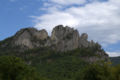
The River Knobs — formerly known as East Seneca Ridge — are a ridge and series of knobs in western Pendleton County, West Virginia
, USA, along a stretch of the North Fork South Branch Potomac River. Although the Knobs (peak elevation: 2,854 ft) are dwarfed by Spruce Mountain
to the west (peak: 4,840 ft) and by North Fork Mountain
to the east (peak: 4,588 ft), they are notable for their series of prominent “razorback” ridges or “fins”. The largest and most famous of these blade-like crag
s is Seneca Rocks
.
to near Seneca Rocks
and are situated in a southwest/northeast orientation. They are a minor part of the High Alleghenies of the Appalachian Mountain Range. Their rock outcrops are clearly visible from WV Route 55 and U.S. Route 33
. Each is associated with a named gap through which a stream has transected the ridge and exposed the bedrock. From north to south the most prominent features are Roy Gap (with its Seneca Rocks
), Harper Knob (2,820 ft), Harper Gap, Harmon Knob (2,854 ft), Hinkle Gap, Germany Knob (2,802 ft), Riverton Gap, Judy Gap (with its Judy Rocks), Nelson Gap (with its Nelson Rocks
), False Gap, Lambert Gap, Pike Gap and Teter Gap.
The Knobs are part of the same structural fold of the earth’s crust that continues to the north as Champe Knobs (with its Champe Rocks
and Yellow Rocks) and to the south as River Hill and (in Virginia
) Lantz Mountain.
 The exposed rock of the River Knobs is a tough quartzite
, Tuscarora Sandstone
, an extremely hard sedimentary rock, ranging in color from a nearly translucent white, to gray, pink or orange. Laid down as sediment on a sea floor 440 million years ago, in West Virginia the Tuscarora is 150 to 250 feet (76.2 m) thick. At the River Knobs, the quartzite layer has been "verticalized" by geological forces during the formation of the Appalachians some 230 million years ago. A folding of the Earth's crust forced this layer - and the surrounding strata - into enormous arches, miles wide. The River Knobs trace the western wall of this arch, or anticline
, where the Tuscarora was turned a full 90 degrees from horizontal to vertical. Over time, erosion stripped away the softer rock covering the arch, and finally the dome of the arch itself. The tough quartzite of the western walls resisted this process, leaving the soaring "fins" - narrow vertical plates of exposed rock. About 2 miles (3.2 km) east, along the top of North Fork Mountain, the horizontal strata of the far slope of the Tuscarora anticline are also visible.
(Within this eroded anticline lies Germany Valley
, registered as a National Natural Landmark
because of its unique karst
topography.)
At Champe Rocks
and Nelson Rocks
the outcroppings are seen as not one, but two parallel fins. The reason for this is that, during the rise of the Appalachians, the same forces which formed the anticline caused the Tuscarora to fault or rupture, with the upper layer sliding over and overlapping the lower. As the top of the arch wore away, two fins were left. Nelson Rocks
is considered one of the best examples of the “faulted Tuscarora”. Seneca Rocks
is a much thicker, monolithic formation because there the rock did not fault cleanly into two layers, but rather rolled over on itself. From Roy Gap, looking north, this effect is clearly visible in the curving layers of rock surrounding the large cave in the south end of Seneca Rocks
.
The River Knobs — formerly known as East Seneca Ridge — are a ridge and series of knobs in western Pendleton County, West Virginia
Pendleton County, West Virginia
As of the census of 2000, there were 8,196 people, 3,350 households, and 2,355 families residing in the county. The population density was 12 people per square mile . There were 5,102 housing units at an average density of 7 per square mile...
, USA, along a stretch of the North Fork South Branch Potomac River. Although the Knobs (peak elevation: 2,854 ft) are dwarfed by Spruce Mountain
Spruce Mountain (West Virginia)
Spruce Mountain, in eastern West Virginia, USA, is the highest ridge of the Allegheny Mountains. The "whale-backed" ridge extends for only about , from northeast to southwest, but several of its peaks exceed in elevation...
to the west (peak: 4,840 ft) and by North Fork Mountain
North Fork Mountain
North Fork Mountain is a quartzite-capped mountain ridge in the Ridge and Valley physiographic province of the Allegheny Mountains of eastern West Virginia, USA...
to the east (peak: 4,588 ft), they are notable for their series of prominent “razorback” ridges or “fins”. The largest and most famous of these blade-like crag
Cliff
In geography and geology, a cliff is a significant vertical, or near vertical, rock exposure. Cliffs are formed as erosion landforms due to the processes of erosion and weathering that produce them. Cliffs are common on coasts, in mountainous areas, escarpments and along rivers. Cliffs are usually...
s is Seneca Rocks
Seneca Rocks
Seneca Rocks is a large crag and local landmark in Pendleton County in the Eastern Panhandle of West Virginia, USA. It is easily visible and accessible along West Virginia Route 28 near U.S. Route 33 in the Spruce Knob-Seneca Rocks National Recreation Area of the Monongahela National Forest...
.
Geography
The River Knobs stretch for about 18 miles (29 km) from near Cherry GroveCherry Grove, West Virginia
Cherry Grove is an unincorporated community located in Pendleton County, West Virginia, USA. Cherry Grove lies within the Monongahela National Forest at the confluence of Big Run with the North Fork South Branch Potomac River....
to near Seneca Rocks
Seneca Rocks, West Virginia
Seneca Rocks is an unincorporated community located in Pendleton County, West Virginia, USA. The community of Seneca Rocks — formerly known as Mouth of Seneca — lies along West Virginia Route 28/West Virginia Route 55 near the confluence of Seneca Creek and the North Fork South Branch Potomac...
and are situated in a southwest/northeast orientation. They are a minor part of the High Alleghenies of the Appalachian Mountain Range. Their rock outcrops are clearly visible from WV Route 55 and U.S. Route 33
U.S. Route 33
U.S. Route 33 is a United States federal highway that runs northwest-southeast for 709 miles from northern Indiana to Richmond, Virginia, passing through Ohio and West Virginia en route. Although most odd-numbered U.S...
. Each is associated with a named gap through which a stream has transected the ridge and exposed the bedrock. From north to south the most prominent features are Roy Gap (with its Seneca Rocks
Seneca Rocks
Seneca Rocks is a large crag and local landmark in Pendleton County in the Eastern Panhandle of West Virginia, USA. It is easily visible and accessible along West Virginia Route 28 near U.S. Route 33 in the Spruce Knob-Seneca Rocks National Recreation Area of the Monongahela National Forest...
), Harper Knob (2,820 ft), Harper Gap, Harmon Knob (2,854 ft), Hinkle Gap, Germany Knob (2,802 ft), Riverton Gap, Judy Gap (with its Judy Rocks), Nelson Gap (with its Nelson Rocks
Nelson Rocks
Nelson Rocks Outdoor Center , previously known as Nelson Rocks Preserve, is an outdoor recreation area located in the North Fork Valley of Pendleton County, West Virginia...
), False Gap, Lambert Gap, Pike Gap and Teter Gap.
The Knobs are part of the same structural fold of the earth’s crust that continues to the north as Champe Knobs (with its Champe Rocks
Champe Rocks
Champe Rocks are a pair of large crags in Pendleton County in the Eastern Panhandle of West Virginia, USA. Easily visible from West Virginia Route 28, they are situated within the Spruce Knob-Seneca Rocks National Recreation Area...
and Yellow Rocks) and to the south as River Hill and (in Virginia
Virginia
The Commonwealth of Virginia , is a U.S. state on the Atlantic Coast of the Southern United States. Virginia is nicknamed the "Old Dominion" and sometimes the "Mother of Presidents" after the eight U.S. presidents born there...
) Lantz Mountain.
Geology
Quartzite
Quartzite is a hard metamorphic rock which was originally sandstone. Sandstone is converted into quartzite through heating and pressure usually related to tectonic compression within orogenic belts. Pure quartzite is usually white to gray, though quartzites often occur in various shades of pink...
, Tuscarora Sandstone
Tuscarora Formation
The Silurian Tuscarora Formation — also known as Tuscarora Sandstone or Tuscarora Quartzite — is a mapped bedrock unit in Pennsylvania, Maryland, West Virginia, and Virginia.-Description:...
, an extremely hard sedimentary rock, ranging in color from a nearly translucent white, to gray, pink or orange. Laid down as sediment on a sea floor 440 million years ago, in West Virginia the Tuscarora is 150 to 250 feet (76.2 m) thick. At the River Knobs, the quartzite layer has been "verticalized" by geological forces during the formation of the Appalachians some 230 million years ago. A folding of the Earth's crust forced this layer - and the surrounding strata - into enormous arches, miles wide. The River Knobs trace the western wall of this arch, or anticline
Anticline
In structural geology, an anticline is a fold that is convex up and has its oldest beds at its core. The term is not to be confused with antiform, which is a purely descriptive term for any fold that is convex up. Therefore if age relationships In structural geology, an anticline is a fold that is...
, where the Tuscarora was turned a full 90 degrees from horizontal to vertical. Over time, erosion stripped away the softer rock covering the arch, and finally the dome of the arch itself. The tough quartzite of the western walls resisted this process, leaving the soaring "fins" - narrow vertical plates of exposed rock. About 2 miles (3.2 km) east, along the top of North Fork Mountain, the horizontal strata of the far slope of the Tuscarora anticline are also visible.
(Within this eroded anticline lies Germany Valley
Germany Valley
Germany Valley is a scenic upland valley high in the Allegheny Mountains of eastern West Virginia originally settled by German farmers in the mid-18th Century...
, registered as a National Natural Landmark
National Natural Landmark
The National Natural Landmark program recognizes and encourages the conservation of outstanding examples of the natural history of the United States. It is the only natural areas program of national scope that identifies and recognizes the best examples of biological and geological features in...
because of its unique karst
KARST
Kilometer-square Area Radio Synthesis Telescope is a Chinese telescope project to which FAST is a forerunner. KARST is a set of large spherical reflectors on karst landforms, which are bowlshaped limestone sinkholes named after the Kras region in Slovenia and Northern Italy. It will consist of...
topography.)
At Champe Rocks
Champe Rocks
Champe Rocks are a pair of large crags in Pendleton County in the Eastern Panhandle of West Virginia, USA. Easily visible from West Virginia Route 28, they are situated within the Spruce Knob-Seneca Rocks National Recreation Area...
and Nelson Rocks
Nelson Rocks
Nelson Rocks Outdoor Center , previously known as Nelson Rocks Preserve, is an outdoor recreation area located in the North Fork Valley of Pendleton County, West Virginia...
the outcroppings are seen as not one, but two parallel fins. The reason for this is that, during the rise of the Appalachians, the same forces which formed the anticline caused the Tuscarora to fault or rupture, with the upper layer sliding over and overlapping the lower. As the top of the arch wore away, two fins were left. Nelson Rocks
Nelson Rocks
Nelson Rocks Outdoor Center , previously known as Nelson Rocks Preserve, is an outdoor recreation area located in the North Fork Valley of Pendleton County, West Virginia...
is considered one of the best examples of the “faulted Tuscarora”. Seneca Rocks
Seneca Rocks
Seneca Rocks is a large crag and local landmark in Pendleton County in the Eastern Panhandle of West Virginia, USA. It is easily visible and accessible along West Virginia Route 28 near U.S. Route 33 in the Spruce Knob-Seneca Rocks National Recreation Area of the Monongahela National Forest...
is a much thicker, monolithic formation because there the rock did not fault cleanly into two layers, but rather rolled over on itself. From Roy Gap, looking north, this effect is clearly visible in the curving layers of rock surrounding the large cave in the south end of Seneca Rocks
Seneca Rocks
Seneca Rocks is a large crag and local landmark in Pendleton County in the Eastern Panhandle of West Virginia, USA. It is easily visible and accessible along West Virginia Route 28 near U.S. Route 33 in the Spruce Knob-Seneca Rocks National Recreation Area of the Monongahela National Forest...
.
Miscellany
- Nelson RocksNelson RocksNelson Rocks Outdoor Center , previously known as Nelson Rocks Preserve, is an outdoor recreation area located in the North Fork Valley of Pendleton County, West Virginia...
Preserve features a via ferrataVia ferrataA via ferrata or klettersteig is a mountain route which is equipped with fixed cables, stemples, ladders, and bridges. The use of these allows otherwise isolated routes to be joined to create longer routes which are accessible to people with a wide range of climbing abilities...
(one of only six in North America), along with a rope bridgeRope bridgeA rope bridge is a bridge constructed chiefly of rope. In its simplest form, it can be one or two ropes that bridge a river, enabling the traveller to be supported in their crossing and not be swept away. One rope above another, for feet and hands, may be referred to as a commando bridge.More...
, 200 feet (61 m) long and 150 feet (45.7 m) high.
External links
- http://www.VisitViaFerrata.com"Geology of Nelson RocksNelson RocksNelson Rocks Outdoor Center , previously known as Nelson Rocks Preserve, is an outdoor recreation area located in the North Fork Valley of Pendleton County, West Virginia...
" (with photos) at the Nelson Rock Preserve website] - “Folded Sedimentary Rocks” (including photos of River Knobs) at Burt Carter’s Home Page