
Sound Transit Central Link
Encyclopedia
Central Link is a light rail
line running between downtown Seattle and Seattle-Tacoma International Airport
. It is the initial phase of Sound Transit
's Link Light Rail
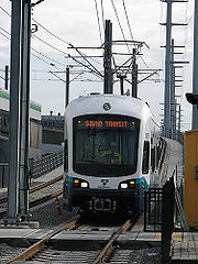
system. Service operates seven days a week, from 5 am to 1 am Monday through Saturday and from 6 am to midnight on Sundays. Trains are composed of two cars, each with a capacity of 200 passengers—74 seated and 126 standing. Opened on July 18, 2009, Central Link initially operated between downtown Seattle
and Tukwila
, on a 13.9 miles (22.4 km) route. Service was extended by 1.7 miles (2.7 km) from Tukwila to SeaTac Airport on December 19, 2009.
. The route serves four of the tunnel's five stations (Convention Place Station being the exception). After exiting the southern end of the tunnel at International District/Chinatown Station, the route joins the SoDo Busway (formerly 5th Avenue S.) as a traffic-separated surface route, where it has priority for all intersections. The route serves two stations on the busway and then rises to an elevated section through the SoDo neighborhood.
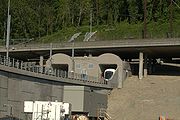
The route then enters a tunnel through Beacon Hill and makes one stop at the underground Beacon Hill Station. Exiting the tunnel, the route becomes grade-separated on an elevated bridge. It serves Mount Baker Station near Franklin High School before it becomes an at-grade surface route on Martin Luther King Jr. Way S. and serves three stations in the Rainier Valley.
 Continuing south on Martin Luther King Jr. Way S., it again becomes grade-separated on an elevated guideway and runs alongside Boeing Access Road, E. Marginal Way S., Interurban Avenue S., SR 599, and I-5. Just north of SR 518, the route turns west and parallels SR 518. It stops at Tukwila International Boulevard Station before crossing International Boulevard
and running in the center of the North Airport Expressway all the way to the southern terminus of SeaTac/Airport Station, an elevated station lying northeast of the parking garage, immediately west of International Boulevard.
 The fares for Link are distance-based: $2.00 base fare plus 5 cent
s per mile, rounded to the nearest 25 cents. The maximum cost of a one-way ticket is $2.75, for a trip between Downtown Seattle and Sea-Tac Airport
. Although Metro buses offer free rides in the Downtown Seattle Transit Tunnel (during the ride-free hours of 6 am to 7 pm), Central Link trains do not. Maintaining the ride-free area for light rail would have resulted in fares 25 cents higher.
Adult fares for Link are as follows:
Seniors
(65+) and the disabled may obtain a permit allowing them to ride for a reduced flat fare of $0.75 per trip. Youth (6–18) can ride for a flat fare of $1.25 per trip.
have their transfer fares calculated automatically. Users of cash and paper tickets can't obtain transfer credit. Their tickets are valid for one ride only unless a Link Round Trip Ticket is purchased, which allows unlimited travel between the stations on the ticket for that service day.
Central Link to Bus or Vice Versa
Only ORCA Cards can be used without having to pay another fare between Central Link and buses in the following agencies: ST Express, King County Metro, Community Transit or Pierce Transit
.
The 36-minute travel time from Westlake Station to SeaTac/Airport Station was similar to the 32-minute scheduled travel time of the now cancelled King County Metro Route 194 bus from Convention Place Station to the airport. Wait times are shorter and access is better, as light rail runs more frequently and during more hours of the day than Route 194 did, and serves more stops between downtown and the airport. Since light rail operates on its own right of way, it is not subject to delays due to traffic congestion.
King County Metro discontinued route 194 on February 6, 2010. Riders who boarded Route 194 at the Kent/Des Moines or Star Lake (272nd) freeway stations and are destined north of the airport now have to board ST
Route 574 and transfer to light rail at SeaTac/Airport Station. Expanded service on Sound Transit routes 577 and 578 now provide a direct connection between the Federal Way Transit Center and Downtown Seattle. Unlike the former route 194, routes 577 and 578 do not serve the Federal Way Park & Ride, but shorten the trip between Downtown and Federal Way by 26 minutes.
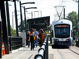
 Kinkisharyo-Mitsui
was chosen to design and manufacture low-floor light rail vehicles and provide additional equipment and support. Thirty-five light rail cars were delivered between November 2006 and September 2008. Each vehicle is 95 ft (29 m) long, 8.7 ft (2.7 m) wide, accommodate 200 people each (74 seated), and double-ended to allow travel in either direction. Two-car trains will be used initially, but as ridership increases, trains can be up to four cars long. Until University Link
construction is completed, only three-car trains can be used due to the length of the stub tracks at the north end interlocking. The maximum speed of the light rail vehicle is 65 mph (104.6 km/h).
An additional 27 LRVs are scheduled to be delivered to Sound Transit by Kinkisharyo at a rate of 1 a month, beginning in August 2010.
The current plan is for 180 total units for the system by 2030.
Light rail
Light rail or light rail transit is a form of urban rail public transportation that generally has a lower capacity and lower speed than heavy rail and metro systems, but higher capacity and higher speed than traditional street-running tram systems...
line running between downtown Seattle and Seattle-Tacoma International Airport
Seattle-Tacoma International Airport
The Seattle–Tacoma International Airport , also known as Sea–Tac Airport or Sea–Tac , is an American airport located in SeaTac, Washington, at the intersections of State Routes 99 and 509 and 518, about west of Interstate 5...
. It is the initial phase of Sound Transit
Sound Transit
Sound Transit has been the popular name of Washington state's Central Puget Sound Regional Transit Authority since September 19, 1999. It was formed in 1996 by the Snohomish, King, and Pierce County Councils...
's Link Light Rail
Link Light Rail
Sound Transit Link Light Rail is a rapid transit project in the Greater Seattle region, originally approved by a ballot measure in November 1996. Two lines are currently operating as of 2009: Tacoma Link, which uses 3 vehicles built by Škoda, and Central Link, which uses 35 vehicles built by Kinki...
system. Service operates seven days a week, from 5 am to 1 am Monday through Saturday and from 6 am to midnight on Sundays. Trains are composed of two cars, each with a capacity of 200 passengers—74 seated and 126 standing. Opened on July 18, 2009, Central Link initially operated between downtown Seattle
Downtown Seattle
Downtown is the central business district of Seattle, Washington. It is fairly compact compared to other city centers on the West Coast because of its geographical situation: hemmed in on the north and east by hills, on the west by the Elliott Bay, and on the south by reclaimed land that was once...
and Tukwila
Tukwila, Washington
Tukwila is a city in King County, Washington, United States. The northern edge of Tukwila borders the city of Seattle. The population was 19,107 at the 2010 census.-History:...
, on a 13.9 miles (22.4 km) route. Service was extended by 1.7 miles (2.7 km) from Tukwila to SeaTac Airport on December 19, 2009.
Routing
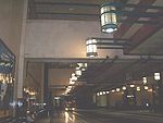
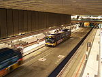
The northern terminus is at Westlake Station near the intersection of Pine Street and 4th Avenue. Central Link trains operate inside the Downtown Seattle Transit Tunnel, sharing the right-of-way with diesel-electric hybrid busesHybrid electric bus
A hybrid electric bus combines a conventional internal combustion engine propulsion system with an electric propulsion system. These type of buses normally use a diesel-electric powertrain and are also known as hybrid diesel-electric buses....
. The route serves four of the tunnel's five stations (Convention Place Station being the exception). After exiting the southern end of the tunnel at International District/Chinatown Station, the route joins the SoDo Busway (formerly 5th Avenue S.) as a traffic-separated surface route, where it has priority for all intersections. The route serves two stations on the busway and then rises to an elevated section through the SoDo neighborhood.
The route then enters a tunnel through Beacon Hill and makes one stop at the underground Beacon Hill Station. Exiting the tunnel, the route becomes grade-separated on an elevated bridge. It serves Mount Baker Station near Franklin High School before it becomes an at-grade surface route on Martin Luther King Jr. Way S. and serves three stations in the Rainier Valley.
Washington State Route 99
State Route 99, abbreviated SR 99, commonly called Highway 99, is a numbered state highway in the U.S. state of Washington extending just under from Fife in the south to Everett in the north, with a gap in Tukwila.-Southern division:...
and running in the center of the North Airport Expressway all the way to the southern terminus of SeaTac/Airport Station, an elevated station lying northeast of the parking garage, immediately west of International Boulevard.
Stations
| Station Name | Opening Year | City/Neighborhood | Location | Platforms | Notes | |
|---|---|---|---|---|---|---|
| End of line; future extension (University Link University Link University Link is a future light rail extension of Sound Transit's Link light rail system in Seattle, Washington, USA. The line will connect downtown Seattle with the University of Washington via Capitol Hill. The line was approved by the Federal Transit Administration in November 2006... ) |
||||||
| Downtown Seattle Transit Tunnel | ||||||
 |
Westlake | 1989 | Downtown Seattle Downtown Seattle Downtown is the central business district of Seattle, Washington. It is fairly compact compared to other city centers on the West Coast because of its geographical situation: hemmed in on the north and east by hills, on the west by the Elliott Bay, and on the south by reclaimed land that was once... |
under 4th Avenue & Pine Street | Outside | Connections to monorail and streetcar South Lake Union Streetcar The Seattle Streetcar—South Lake Union Line is a streetcar line connecting the South Lake Union neighborhood to Downtown Seattle, United States. Service began on December 12, 2007... . |
 |
University Street | 1989 | Downtown Seattle Downtown Seattle Downtown is the central business district of Seattle, Washington. It is fairly compact compared to other city centers on the West Coast because of its geographical situation: hemmed in on the north and east by hills, on the west by the Elliott Bay, and on the south by reclaimed land that was once... |
under 3rd Avenue & University Street | Outside | |
 |
Pioneer Square | 1989 | Pioneer Square, Seattle Pioneer Square, Seattle, Washington Pioneer Square is a neighborhood in the southwest corner of Downtown Seattle, Washington, USA. It was once the heart of the city: Seattle's founders settled there in 1852, following a brief six-month settlement at Alki Point on the far side of Elliott Bay. The early structures in the neighborhood... |
under 3rd Avenue & Cherry Street | Outside | |
| |
International District/Chinatown | 1989 | International District / Chinatown, Seattle International District, Seattle, Washington The Chinatown-International District of Seattle, Washington is an ethnic enclave neighborhood and is the center of Seattle's Asian American community. The neighborhood is multiethnic, consisting mainly of people who are of Chinese, Japanese, and Filipino ethnicity... |
under Union Station Union Station (Seattle) Union Station is a former train station in Seattle, Washington, USA, constructed between 1910 and 1911 to serve the Union Pacific Railroad and the Milwaukee Road. It was originally named Oregon and Washington Station, after a subsidiary line of the Union Pacific. Located at the corner of S. Jackson... at 5th Avenue S. & S. Jackson Street |
Outside | |
| Connection to future extension (East Link East Link East Link is a planned eastern extension of the Sound Transit Link Light Rail system, spanning about 22 miles from Downtown Seattle to the city of Redmond... ) |
||||||
| Surface | ||||||
| |
Stadium | 2009 | SoDo, Seattle SoDo, Seattle, Washington SoDo is a neighborhood in Seattle, Washington, that makes up part of the city's Industrial District. It is bounded on the north by South King Street, beyond which is Pioneer Square; on the south by South Spokane Street, beyond which is more of the Industrial District; on the west by the Duwamish... |
SoDo Busway & S. Royal Brougham Way |
Center | Larger platform to serve Safeco Field Safeco Field Safeco Field is a retractable roof baseball stadium located in Seattle, Washington. The stadium, owned and operated by the Washington-King County Stadium Authority, is the home stadium of the Seattle Mariners of Major League Baseball and has a seating capacity of 47,878 for baseball... and CenturyLink Field |
| |
SODO | 2009 | SoDo, Seattle SoDo, Seattle, Washington SoDo is a neighborhood in Seattle, Washington, that makes up part of the city's Industrial District. It is bounded on the north by South King Street, beyond which is Pioneer Square; on the south by South Spokane Street, beyond which is more of the Industrial District; on the west by the Duwamish... |
SoDo Busway & S. Lander Street | Outside | |
| Tunnel | ||||||
| |
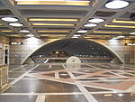
Beacon Hill | 2009 | Beacon Hill, Seattle Beacon Hill, Seattle, Washington Beacon Hill is a hill and neighborhood in southeast Seattle, Washington. The municipal government subdivides it into North Beacon Hill, Mid-Beacon Hill, Holly Park, and South Beacon Hill, though most people who live there simply call it "Beacon Hill." Home to the world headquarters of Amazon.com... |
under Beacon Avenue S. & S. Lander Street | Center | |
| Elevated | ||||||
| |
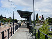
Mount Baker | 2009 | Mount Baker, Seattle Mount Baker, Seattle, Washington Mount Baker is a neighborhood in southeast Seattle. The neighborhood's name comes from the view of Mount Baker in Whatcom County, that is seen by looking north over Lake Washington. It is bounded by Lake Washington to the east, Interstate 90 and then Leschi to the north, Rainier Valley to the west,... |
Martin Luther King Jr. Way S. & Rainier Avenue S. | Outside | |
| Surface (Martin Luther King Jr. Way) | ||||||
 |
Columbia City | 2009 | Columbia City, Seattle Columbia City, Seattle, Washington Columbia City is a neighborhood in the Rainier Valley area of southeast Seattle, Washington, known either for being one of the "hottest" neighborhoods in Seattle, or for its rapid gentrification, depending on one's perspective... |
MLK Jr. Way S. between S. Edmunds & S. Alaska Streets |
Outside | |
 |
Othello | 2009 | New Holly Beacon Hill, Seattle, Washington Beacon Hill is a hill and neighborhood in southeast Seattle, Washington. The municipal government subdivides it into North Beacon Hill, Mid-Beacon Hill, Holly Park, and South Beacon Hill, though most people who live there simply call it "Beacon Hill." Home to the world headquarters of Amazon.com... , Seattle |
MLK Jr. Way S. between S. Othello & S. Myrtle Streets |
Outside | |
 |
Rainier Beach | 2009 | Rainier Valley, Seattle Rainier Valley, Seattle, Washington The Rainier Valley neighborhood in Seattle, is located east of Beacon Hill; west of Mount Baker, Seward Park, and Leschi; south of the Central District and First Hill; and north of the city line... |
MLK Jr. Way S. & S. Henderson Street | Center | |
| Elevated | ||||||
| Tukwila International Blvd | 2009 | Tukwila Tukwila, Washington Tukwila is a city in King County, Washington, United States. The northern edge of Tukwila borders the city of Seattle. The population was 19,107 at the 2010 census.-History:... |
SR 518 & Tukwila International Blvd Washington State Route 99 State Route 99, abbreviated SR 99, commonly called Highway 99, is a numbered state highway in the U.S. state of Washington extending just under from Fife in the south to Everett in the north, with a gap in Tukwila.-Southern division:... |
Outside | 600-space park & ride lot | |
| SeaTac/Airport | 2009 | SeaTac SeaTac, Washington SeaTac is an American city in southern King County, Washington, and an outlying suburb of Seattle, Washington. Incorporated in February 1990, the City of SeaTac is ten square miles in area and has a population of 26,909 according to the 2010 census... |
East of airport parking garage | Center | Pedestrian bridges to main terminal and kiss-and-ride center at International Blvd Washington State Route 99 State Route 99, abbreviated SR 99, commonly called Highway 99, is a numbered state highway in the U.S. state of Washington extending just under from Fife in the south to Everett in the north, with a gap in Tukwila.-Southern division:... |
|
| End of line; future extension (South Link South Link (Link Light Rail) South Link is a planned southern extension of the Central Link light rail line, spanning about 23 miles from Sea-Tac Airport to Tacoma Dome Station in Tacoma, Washington, USA.- Routing :... ) |
||||||
Fares
Cent
Cent may refer to:In currency:*Cent , a one-hundredth subdivision of several units of currency*Cent , a Canadian coin*Cent , the Dutch coin minted between 1941 and 1944*Cent , a European coin...
s per mile, rounded to the nearest 25 cents. The maximum cost of a one-way ticket is $2.75, for a trip between Downtown Seattle and Sea-Tac Airport
Seattle-Tacoma International Airport
The Seattle–Tacoma International Airport , also known as Sea–Tac Airport or Sea–Tac , is an American airport located in SeaTac, Washington, at the intersections of State Routes 99 and 509 and 518, about west of Interstate 5...
. Although Metro buses offer free rides in the Downtown Seattle Transit Tunnel (during the ride-free hours of 6 am to 7 pm), Central Link trains do not. Maintaining the ride-free area for light rail would have resulted in fares 25 cents higher.
Adult fares for Link are as follows:
| Westlake | ||||||||||||
|---|---|---|---|---|---|---|---|---|---|---|---|---|
| $2.00 | University Street | |||||||||||
| $2.00 | $2.00 | Pioneer Square | ||||||||||
| $2.00 | $2.00 | $2.00 | International District/Chinatown | |||||||||
| $2.00 | $2.00 | $2.00 | $2.00 | Stadium | ||||||||
| $2.00 | $2.00 | $2.00 | $2.00 | $2.00 | SODO | |||||||
| $2.00 | $2.00 | $2.00 | $2.00 | $2.00 | $2.00 | Beacon Hill | ||||||
| $2.25 | $2.25 | $2.25 | $2.25 | $2.00 | $2.00 | $2.00 | Mount Baker | |||||
| $2.25 | $2.25 | $2.25 | $2.25 | $2.00 | $2.00 | $2.00 | $2.00 | Columbia City | ||||
| $2.25 | $2.25 | $2.25 | $2.25 | $2.25 | $2.25 | $2.25 | $2.00 | $2.00 | Othello | |||
| $2.25 | $2.25 | $2.25 | $2.25 | $2.25 | $2.25 | $2.25 | $2.25 | $2.00 | $2.00 | Rainier Beach | ||
| $2.75 | $2.75 | $2.75 | $2.75 | $2.50 | $2.50 | $2.50 | $2.50 | $2.25 | $2.25 | $2.25 | Tukwila International Blvd | |
| $2.75 | $2.75 | $2.75 | $2.75 | $2.75 | $2.50 | $2.50 | $2.50 | $2.50 | $2.50 | $2.25 | $2.00 | SeaTac/Airport |
Seniors
Senior citizen
Senior citizen is a common polite designation for an elderly person in both UK and US English, and it implies or means that the person is retired. This in turn implies or in fact means that the person is over the retirement age, which varies according to country. Synonyms include pensioner in UK...
(65+) and the disabled may obtain a permit allowing them to ride for a reduced flat fare of $0.75 per trip. Youth (6–18) can ride for a flat fare of $1.25 per trip.
Transfers
Users of the ORCA CardOrca Card
The ORCA ' Card is a contactless, stored value smart card used for payment of public transport fares in the Puget Sound region...
have their transfer fares calculated automatically. Users of cash and paper tickets can't obtain transfer credit. Their tickets are valid for one ride only unless a Link Round Trip Ticket is purchased, which allows unlimited travel between the stations on the ticket for that service day.
Central Link to Bus or Vice Versa
Only ORCA Cards can be used without having to pay another fare between Central Link and buses in the following agencies: ST Express, King County Metro, Community Transit or Pierce Transit
Pierce Transit
Pierce Transit, in full the Pierce County Public Transportation Benefit Area Corporation, is the public transit authority of Pierce County, Washington. Based in Lakewood, Washington, it was founded in 1979...
.
Headways
Central Link operates on the following schedule:| Time | Headway Headway Headway is a measurement of the distance/time between vehicles in a transit system. The precise definition varies depending on the application, but it is most commonly measured as the distance from the tip of one vehicle to the tip of the next one behind it, expressed as the time it will take for... |
|
|---|---|---|
| Monday through Friday |
5:00 am - 6:00 am | 15 |
| 6:00 am - 8:30 am | 7.5 | |
| 8:30 am - 3:00 pm | 10 | |
| 3:00 pm - 6:30 pm | 7.5 | |
| 6:30 pm - 10:00 pm | 10 | |
| 10:00 pm - 1:00 am | 15 | |
| Saturday | 5:00 am - 8:00 am | 15 |
| 8:00 am - 10:00 pm | 10 | |
| 10:00 pm - 1:00 am | 15 | |
| Sunday | 6:00 am - 8:00 am | 15 |
| 8:00 am - 10:00 pm | 10 | |
| 10:00 pm - 12:00 midnight | 15 |
Travel Times
The vehicles operate at a maximum and cruising speed of 55 mph (88.5 km/h), with an end-to-end travel time of 36 minutes over the 15.6 miles (25.1 km) route between Westlake and SeaTac/Airport. Travel times are as follows; all times measured in minutes.| Westlake | ||||||||||||
|---|---|---|---|---|---|---|---|---|---|---|---|---|
| 2 | University Street | |||||||||||
| 4 | 2 | Pioneer Square | ||||||||||
| 6 | 4 | 2 | International District/Chinatown | |||||||||
| 8 | 6 | 4 | 2 | Stadium | ||||||||
| 10 | 7 | 6 | 4 | 2 | SODO | |||||||
| 13 | 11 | 9 | 7 | 5 | 2 | Beacon Hill | ||||||
| 14 | 12 | 10 | 8 | 6 | 5 | 3 | Mount Baker | |||||
| 17 | 15 | 13 | 11 | 9 | 8 | 5 | 3 | Columbia City | ||||
| 22 | 19 | 18 | 16 | 14 | 12 | 9 | 8 | 5 | Othello | |||
| 25 | 23 | 21 | 19 | 17 | 16 | 13 | 11 | 8 | 4 | Rainier Beach | ||
| 34 | 32 | 30 | 28 | 26 | 24 | 21 | 20 | 17 | 12 | 9 | Tukwila International Blvd | |
| 36 | 34 | 32 | 30 | 28 | 27 | 24 | 22 | 19 | 15 | 11 | 2 | SeaTac/Airport |
The 36-minute travel time from Westlake Station to SeaTac/Airport Station was similar to the 32-minute scheduled travel time of the now cancelled King County Metro Route 194 bus from Convention Place Station to the airport. Wait times are shorter and access is better, as light rail runs more frequently and during more hours of the day than Route 194 did, and serves more stops between downtown and the airport. Since light rail operates on its own right of way, it is not subject to delays due to traffic congestion.
King County Metro discontinued route 194 on February 6, 2010. Riders who boarded Route 194 at the Kent/Des Moines or Star Lake (272nd) freeway stations and are destined north of the airport now have to board ST
Sound Transit
Sound Transit has been the popular name of Washington state's Central Puget Sound Regional Transit Authority since September 19, 1999. It was formed in 1996 by the Snohomish, King, and Pierce County Councils...
Route 574 and transfer to light rail at SeaTac/Airport Station. Expanded service on Sound Transit routes 577 and 578 now provide a direct connection between the Federal Way Transit Center and Downtown Seattle. Unlike the former route 194, routes 577 and 578 do not serve the Federal Way Park & Ride, but shorten the trip between Downtown and Federal Way by 26 minutes.
Ridership
Ridership has been mostly rising since the line opened in July 2009 and had 12,000 boardings per weekday. Ridership has continued to rise each month, with average weekday ridership at 21,774 by May 2010. The completion of the line to its ultimate destination, the airport, subsequent passengers from closing Route 194, and shifting of bus routes to feed into the light rail contributed to the increase. Sound Transit measures ridership by using the infrared sensors built into the doorways.Equipment
Kinkisharyo-Mitsui
Kinkisharyo-Mitsui is a joint venture between Kinki Sharyo International LLC and Mitsui & Co. Inc. that specializes in manufacturing public transit vehicles....
was chosen to design and manufacture low-floor light rail vehicles and provide additional equipment and support. Thirty-five light rail cars were delivered between November 2006 and September 2008. Each vehicle is 95 ft (29 m) long, 8.7 ft (2.7 m) wide, accommodate 200 people each (74 seated), and double-ended to allow travel in either direction. Two-car trains will be used initially, but as ridership increases, trains can be up to four cars long. Until University Link
University Link
University Link is a future light rail extension of Sound Transit's Link light rail system in Seattle, Washington, USA. The line will connect downtown Seattle with the University of Washington via Capitol Hill. The line was approved by the Federal Transit Administration in November 2006...
construction is completed, only three-car trains can be used due to the length of the stub tracks at the north end interlocking. The maximum speed of the light rail vehicle is 65 mph (104.6 km/h).
An additional 27 LRVs are scheduled to be delivered to Sound Transit by Kinkisharyo at a rate of 1 a month, beginning in August 2010.
The current plan is for 180 total units for the system by 2030.
See also
- History of Link Light RailHistory of Link Light RailSound Transit's Link Light Rail currently consists of two lines, Central Link and Tacoma Link.-Early years:In 1996, voters in King, Pierce, and Snohomish counties approved increases in sales taxes and vehicle excise taxes to pay for a US$3.9 billion transit package that included $1.7 billion for a...
- Tacoma Link
- University LinkUniversity LinkUniversity Link is a future light rail extension of Sound Transit's Link light rail system in Seattle, Washington, USA. The line will connect downtown Seattle with the University of Washington via Capitol Hill. The line was approved by the Federal Transit Administration in November 2006...
- List of rapid transit systems
External links
- Central Link System Map at soundtransit.org.
- Central Link ride along video at The Seattle Times.
- Official Sound Transit website
- Puget Sound Transportation Projects: Seattle Link
- Photos of Sound Transit Flickr group, includes photos of Central Link.
- Kinkisharyo Technical specs for Link Light Rail Vehicles