

Transport in the Faroe Islands
Encyclopedia
International transport, both for passengers and freight, remains difficult due to high costs, low numbers, long distances, and weather-related difficulties, especially in wintertime. The exporting of domestically produced commodities is hence quite expensive; this limits the development of a commodity-based economy.
History
The general history of the FaroeseFaroe Islands
The Faroe Islands are an island group situated between the Norwegian Sea and the North Atlantic Ocean, approximately halfway between Scotland and Iceland. The Faroe Islands are a self-governing territory within the Kingdom of Denmark, along with Denmark proper and Greenland...
transportation-system can be summed up into four general periods:
19th century and earlier
In the first period stretching from the feudal era into the beginning of the 20th century transportation was made mainly by a combination of rowing boats, walking, carrying, and horse-transport in certain places for upper social classes.The late 19th century onwards
In the second period, starting in the late 19th century the ferry-connections start to emerge. First through private initiatives and in the 20th century increasingly transforming into public transport further supplemented by the emerging automobilism, especially during and between the two world wars. After World War II a large part of the Faroe Islands was reachable through a combination of ferries and automobiles — frequently private buses and taxis.The mid 20th century
The third period included a modernization of the ferries, introducing the car-ferries, making it possible to drive between the large centres of the country. Soon it would be possible to drive all the way from the capital of TórshavnTórshavn
Tórshavn is the capital and largest town of the Faroe Islands. It is located in the southern part on the east coast of Streymoy. To the north west of the town lies the high mountain Húsareyn, and to the southwest, the high Kirkjubøreyn...
to Vágur
Vágur
Vágur meaning Bay is a town on the Faroe Islands of Suðuroy, it is situated on the east coast of the island on the Vágsfjørður fjord, and dates from the fourteenth century. Expansion has meant that the nearby town of Nes is now a suburb of Vágur...
and Tvøroyri
Tvøroyri
Tvøroyri lies picturesquely on the north side of the Trongisvágsfjørður on the east coast of Suðuroy, Faroe Islands....
in the south, to Fuglafjørður
Fuglafjørður
Fuglafjørður is a village on Eysturoy's east coast in the Faroe Islands. Its name means "fjord of birds".* Population: 1562* Location: * Postal code : FO 530* Municipality: Fuglafjardar* Football team: ÍF Fuglafjørður...
and Klaksvík
Klaksvík
Klaksvík is the second largest town of the Faroe Islands.The town is located on Borðoy, which is one of the northernmost islands ....
in the north and to the airport at Sørvágur
Sørvágur
Sørvágur is a village on the island of Vágoy in the Faroe Islands. It is located at the landward end of Sørvágsfjørður. Sørvágur is the largest village in the municipality of Sørvágs Kommuna.-Name:...
in the west.
Vágar Airport
Vágar Airport
Vágar Airport is the only airport in the Faroe Islands, a self-governing territory of the Kingdom of Denmark, and is located east of Sørvágur. Due to the Faroe Islands' rather anomalous status, the airport is not fully subject to the rules of the European Union...
was built by the British during World War II; it was reopened as a civilian international airport in 1963.
During this second period the road network was further extended and supplemented by tunnels to distant valleys and firths such as Hvalba
Hvalba
Hvalba is a village and a municipality, which consists of Hvalba, Nes-Hvalba and Sandvík. The total population of Hvalba Municipality was 723 as of 1 January 2010; the population of Hvalba and Nes was 626 and the population of Sandvík was 97. Hvalba is one of the larger villages in the Faroe...
, Sandvík
Sandvík
Sandvík is the northernmost village of the island of Suðuroy in the Faroe Islands. It is situated on the northern side of a shallow fjord. The small village was earlier known as Hvalvík until 1913...
and Norðdepil
Norðdepil
Norðdepil is a town on the island of Borðoy in the Norðoyar Region of the Faroes.*Population: 169 *Postal Code: FO-730*Municipality: Hvannasunds kommuna...
in the 1960s. Thus the third period stretches from the World War II to around 1970.
The late 20th century onwards
Norðskáli
Norðskáli is a settlement in the Faroe Islands on the island of Eysturoy at , a few kilometres north of Oyri. Its name means north dwelling and its population is 249....
on Eysturoy
Eysturoy
Eysturoy means East island and is the second-largest of the Faroe Islands in the North Atlantic, both in size and population. It is separated by a narrow sound from the main island of Streymoy. Eysturoy is extremely rugged, with some 66 separate mountain peaks, including Slættaratindur, the...
and Nesvík
Nesvík
Nesvík is a village on the east coast of the Faroese island of Streymoy, located in the Sunda municipality. Its postal code is FO 437. In 2005 its population was 1. Nesvík is home to a religious camp of the conservative Inner Mission of the national church, and a conference center called Leguhusið...
on Streymoy
Streymoy
Streymoy is the largest and most populated island of the Faroe Islands. The capital, Tórshavn is located there. The name means "island of currents".- Geography :...
. In 1976 the new tunnel between Norðskáli and the rest of Eysturoy was established, and together with the bridge this meant that the two largest islands were suddenly connected into what is now referred to as "Meginlandið" — (the Mainland). In 1975 the causeway
Causeway
In modern usage, a causeway is a road or railway elevated, usually across a broad body of water or wetland.- Etymology :When first used, the word appeared in a form such as “causey way” making clear its derivation from the earlier form “causey”. This word seems to have come from the same source by...
between Viðoy
Viðoy
Viðoy is the northern-most island in the Faroe Islands, located east of Borðoy to which it is linked via a causeway. The name means wood island, despite the fact that no trees grow on the island: the name relates to the driftwood that floats in from Siberia and North America.- Geography :The...
and Borðoy
Borðoy
Borðoy is an island in the north-east of the Faroe Islands. There are eight settlements: Klaksvík , Norðoyri, Ánir, Árnafjørður, Strond, Norðtoftir, Depil and Norðdepil. There are also three abandoned settlements: Skálatoftir, Múli and Fossá, all in the north...
was established, and in 1986 a similar one between Borðoy and Kunoy
Kunoy
Kunoy is an island located in the north-east of the Faroe Islands between Kalsoy and Borðoy .- Settlements and transport :...
was established, and in 1992 the capital Tórshavn was granted a 1st class connection to the northern parts of the country, creating the infrastructural prerequisites for a new mobile society on the Mainland.
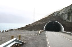
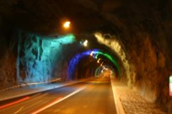
The newest developments of the Faroese transportation network are the sub-sea tunnels. In 2002 the tunnel between Streymoy and Vágar — the latter is the airport island — was finished, and in 2006 the Norðoyatunnilin
Norðoyatunnilin
Norðoyatunnilin is with 6,300 m the longest tunnel of the Faroe Islands. It connects the town of Leirvík on Eysturoy under the strait Leirvíksfjørður with the city of Klaksvík on Borðoy....
between Eysturoy and Borðoy was finished. A toll (payable at petrol stations) of 170 DKK is charged to drive through these two tunnels, the others are free. Now more than 85% of the Faroese population is mutually reachable by automobile.
Railways
There are no railways on the Faroe Islands due to the difficult landscape, small population and the relatively short distances.Roads
Roads have become the main transport
Transport
Transport or transportation is the movement of people, cattle, animals and goods from one location to another. Modes of transport include air, rail, road, water, cable, pipeline, and space. The field can be divided into infrastructure, vehicles, and operations...
artery of Faroese society.
Highways
total: 960 km (596.5 mi)- national highwayHighwayA highway is any public road. In American English, the term is common and almost always designates major roads. In British English, the term designates any road open to the public. Any interconnected set of highways can be variously referred to as a "highway system", a "highway network", or a...
s: 460 km (285.8 mi) - local roads: 500 km (310.7 mi)
Bus services
There is an extensive busBus
A bus is a road vehicle designed to carry passengers. Buses can have a capacity as high as 300 passengers. The most common type of bus is the single-decker bus, with larger loads carried by double-decker buses and articulated buses, and smaller loads carried by midibuses and minibuses; coaches are...
network — with red painted Bussleiðin town buses serving Tórshavn and the blue Bygdaleiðir buses linking the rest of the islands. Most buses are modern and were built by the Volvo
Volvo
AB Volvo is a Swedish builder of commercial vehicles, including trucks, buses and construction equipment. Volvo also supplies marine and industrial drive systems, aerospace components and financial services...
company.
The network of Bygdaleiðir blue rural buses (as well as the ferries) is operated by Strandfaraskip Landsins on behalf of the Faroese government (which provides subsidies). The principal route is Tórshavn-Klaksvík
Klaksvík
Klaksvík is the second largest town of the Faroe Islands.The town is located on Borðoy, which is one of the northernmost islands ....
(via the new Norðoyatunnilin
Norðoyatunnilin
Norðoyatunnilin is with 6,300 m the longest tunnel of the Faroe Islands. It connects the town of Leirvík on Eysturoy under the strait Leirvíksfjørður with the city of Klaksvík on Borðoy....
tunnel), but other bus routes also serve most villages. Bygdaleiðir means "village routes"; individual buses are largely owned by individuals or small companies - but the timetables, fares, and levels of service are set by Strandfaraskip Landsins
Strandfaraskip Landsins
Strandfaraskip Landsins is the public transport company of the Faroe Islands. It is owned by the Faroese government and runs ferries and buses ....
and the government.
Bussleiðin is the name of the urban bus service (with five routes) operated by the Tórshavn municipality. Since 1 January 2007, buses within Torshavn have been completely free of charge to the public. This is intended as an environmentally-friendly programme making people use public transport instead of their cars. As with Bygdaleiðir, the actual buses are privately owned, but contracted to Bussleiðin.
Sea
Ports and harbours
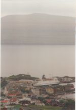
- TorshavnTórshavnTórshavn is the capital and largest town of the Faroe Islands. It is located in the southern part on the east coast of Streymoy. To the north west of the town lies the high mountain Húsareyn, and to the southwest, the high Kirkjubøreyn...
- KlaksvíkKlaksvíkKlaksvík is the second largest town of the Faroe Islands.The town is located on Borðoy, which is one of the northernmost islands ....
- TvøroyriTvøroyriTvøroyri lies picturesquely on the north side of the Trongisvágsfjørður on the east coast of Suðuroy, Faroe Islands....
- VágurVágurVágur meaning Bay is a town on the Faroe Islands of Suðuroy, it is situated on the east coast of the island on the Vágsfjørður fjord, and dates from the fourteenth century. Expansion has meant that the nearby town of Nes is now a suburb of Vágur...
- VestmannaVestmannaVestmanna is a town in the Faroe Islands on the west of the island of Streymoy. It was formerly a ferry port, until an undersea tunnel was built from Vágar to Kvívík and Stykkið. The cliffs west of Vestmanna, Vestmannabjørgini are very popular for excursions by boat.A 'Vestmann' was a "Westman",...
- KollafjørðurKollafjørðurKollafjørður is a village in the Faroe Islands located on the island of Streymoy at 62°7′6″N, 6°54′20″W with a population of 822. Its postal code is FO 410. It is part of the Tórshavnar municipality.-See also:* List of towns in the Faroe Islands...
- RunavíkRunavíkRunavík is a comparatively urbanised village in the Faroe Islands. It lies on the south half of the isle of Eysturoy. The municipality of the same name incorporates 14 settlements including Æðuvík, Rituvík, Saltangará, Glyvrar, Lambi, Lambareiði, Søldarfjørður, Skipanes, Skáli, Skálafjørður,...
- FuglafjørðurFuglafjørðurFuglafjørður is a village on Eysturoy's east coast in the Faroe Islands. Its name means "fjord of birds".* Population: 1562* Location: * Postal code : FO 530* Municipality: Fuglafjardar* Football team: ÍF Fuglafjørður...
Merchant marine
total: 6 ships ( or over) totaling / (1999 est.)- ships by type:
- cargo shipCargo shipA cargo ship or freighter is any sort of ship or vessel that carries cargo, goods, and materials from one port to another. Thousands of cargo carriers ply the world's seas and oceans each year; they handle the bulk of international trade...
2, - petroleum tankerOil tankerAn oil tanker, also known as a petroleum tanker, is a merchant ship designed for the bulk transport of oil. There are two basic types of oil tankers: the crude tanker and the product tanker. Crude tankers move large quantities of unrefined crude oil from its point of extraction to refineries...
1, - refrigerated cargo ship 1,
- roll-on/roll-off 1,
- short-sea passenger 1.
- cargo ship
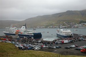
Ferries
The Faroese ferry company Strandfaraskip LandsinsStrandfaraskip Landsins
Strandfaraskip Landsins is the public transport company of the Faroe Islands. It is owned by the Faroese government and runs ferries and buses ....
operates a network of ferries (as well as the rural buses). Their largest vessel is the new Smyril, a roll-on/roll-off ferry which maintains the link between Tórshavn and the southern islands. This vessel entered service in 2005.
Since the early 1980s Smyril Line has operated a regular international passenger, car and freight service using a large, modern, multi-purpose ferry - the Norröna. The weekly service links the Faroe Islands with Seyðisfjörður
Seyðisfjörður
Seyðisfjörður is a town and municipality in the Eastfjords of Iceland at the innermost point of the fjord of the same name.As of January 2011, the town has 668 inhabitants....
in Iceland
Iceland
Iceland , described as the Republic of Iceland, is a Nordic and European island country in the North Atlantic Ocean, on the Mid-Atlantic Ridge. Iceland also refers to the main island of the country, which contains almost all the population and almost all the land area. The country has a population...
and with Hirtshals
Hirtshals
Hirtshals is a town in Hjørring municipality in Region Nordjylland on the north coast of the island of Vendsyssel-Thy at the top of the Jutland peninsula in northern Denmark, Europe.-The town of Hirtshals:...
in Denmark
Denmark
Denmark is a Scandinavian country in Northern Europe. The countries of Denmark and Greenland, as well as the Faroe Islands, constitute the Kingdom of Denmark . It is the southernmost of the Nordic countries, southwest of Sweden and south of Norway, and bordered to the south by Germany. Denmark...
.
Airports
1 (Vágar AirportVágar Airport
Vágar Airport is the only airport in the Faroe Islands, a self-governing territory of the Kingdom of Denmark, and is located east of Sørvágur. Due to the Faroe Islands' rather anomalous status, the airport is not fully subject to the rules of the European Union...
) (2005)
- AirportAirportAn airport is a location where aircraft such as fixed-wing aircraft, helicopters, and blimps take off and land. Aircraft may be stored or maintained at an airport...
s - with paved runways - total: 1
- 914 to 1523 m (2,998.7 to 4,996.7 ): 1