
Vágur
Encyclopedia
| Vágur | |||
|---|---|---|---|
|
|||
| Country Country A country is a region legally identified as a distinct entity in political geography. A country may be an independent sovereign state or one that is occupied by another state, as a non-sovereign or formerly sovereign political division, or a geographic region associated with a previously... |
 Faroe Islands Faroe Islands |
||
| Island | Suðuroy Suðuroy Suðuroy is the southernmost of the Faroe Islands. The island covers 163.7 km². In 2010 there were 4763 inhabitants, but there has been a gradual decline in the population numbers ever since the 1950s.... |
||
| Municipality Municipality A municipality is essentially an urban administrative division having corporate status and usually powers of self-government. It can also be used to mean the governing body of a municipality. A municipality is a general-purpose administrative subdivision, as opposed to a special-purpose district... |
Vágs kommuna | ||
| Danish name | Våg | ||
| Phonetic transcription | 'Våavur | ||
| Population | 1361 (2010) | ||
| Postal code | FO 900 | ||
| mayor Mayor In many countries, a Mayor is the highest ranking officer in the municipal government of a town or a large urban city.... |
Kirstin Strøm Bech | ||
| Homepage | Official homepage | ||
| Coordinates | 61°33′21″N 6°48′12″W | ||

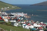
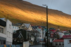
Vágur meaning Bay is a town on the Faroe Islands
Faroe Islands
The Faroe Islands are an island group situated between the Norwegian Sea and the North Atlantic Ocean, approximately halfway between Scotland and Iceland. The Faroe Islands are a self-governing territory within the Kingdom of Denmark, along with Denmark proper and Greenland...
of Suðuroy
Suðuroy
Suðuroy is the southernmost of the Faroe Islands. The island covers 163.7 km². In 2010 there were 4763 inhabitants, but there has been a gradual decline in the population numbers ever since the 1950s....
, it is situated on the east coast of the island
Island
An island or isle is any piece of sub-continental land that is surrounded by water. Very small islands such as emergent land features on atolls can be called islets, cays or keys. An island in a river or lake may be called an eyot , or holm...
on the Vágsfjørður
Vágsfjørður
Vágsfjørður is a fjord on the island of Suðuroy in the Faroe Islands. The fjord is located in the southern part and on the eastern side of the island. The distance between the east and the west coast of Suðuroy is very short from Vágsfjørður to Vágseiði. Between the fjord and Vágseiði is a lake...
fjord
Fjord
Geologically, a fjord is a long, narrow inlet with steep sides or cliffs, created in a valley carved by glacial activity.-Formation:A fjord is formed when a glacier cuts a U-shaped valley by abrasion of the surrounding bedrock. Glacial melting is accompanied by rebound of Earth's crust as the ice...
, and dates from the fourteenth century. Expansion has meant that the nearby town of Nes
Nes, Vágur
Nes is a village on the Faroese island of Suðuroy located in the municipality of Vágur . It is located west of Porkeri and east of Vágur. Its postal code is FO 925. It should not be confused with another village by the same name on Eysturoy . There is another village in Suðuroy with the same...
is now a suburb of Vágur. Vágur has a sports hall next to the football grounds on Eiðinum, near Vágseiði, a swimmingpool by the school and a clinic which offers the services of doctors, nurses and dentists. There is also a hotel, one bank and various shops.
The port area, which is 14 m in depth, is situated on the northern part of the fjord. The port authorities can offer services of piloting (lods), water and fire-fighting, and in connection with the harbour there is a modern fish factory and auctioneers for fish. Salmon farming is also a part of the fish industry in Vágur, this includes salmon farm rings on the fjord and in other places near the east coast of Suðuroy and a salmon factory.
The town has a slipway, a fleet of fishing vessels and a filleting factory.
Nólsoyar Páll Memorial in Memory of Royndin Fríða - The First Faroese Ship
There is a memorial near the main road through Vágur commemorating the efforts of Nólsoyar PállNólsoyar Páll
Nólsoyar Páll is a Faroese national hero. He was a seaman, trader, poet, farmer and boat builder who tried to develop direct trade between the Faroes and the rest of Europe and introduced vaccination to the islands...
, the nineteenth-century poet and captain of Royndin Fríða (Beautiful Trial). He believed that the monopoly trading scheme was seriously restricting the economic potential of the Faroe Islands
Faroe Islands
The Faroe Islands are an island group situated between the Norwegian Sea and the North Atlantic Ocean, approximately halfway between Scotland and Iceland. The Faroe Islands are a self-governing territory within the Kingdom of Denmark, along with Denmark proper and Greenland...
and set about organising opposition and resistance to it. Although he failed to abolish the monopolies, his actions were the start of a process which eventually led to the abolition of monopoly trading in 1856. The memorial was erected in memory of the fact that in 1804 on this spot, now called Fløtan Fríða, the first Faroese
Faroe Islands
The Faroe Islands are an island group situated between the Norwegian Sea and the North Atlantic Ocean, approximately halfway between Scotland and Iceland. The Faroe Islands are a self-governing territory within the Kingdom of Denmark, along with Denmark proper and Greenland...
ship since the Middle Ages was built. The text on the memorial says: "Her á Fløtuni Fríðu bygdu Nólsoyar Páll, Jákup bóndi í Toftum, Per bóndi í Gjørðum og aðrir í 1804 Føroya fyrsta skip Royndina Fríðu." - "Here on Fløtan Fríða Nólsoyar Páll, Jákup bóndi í Toftum (a farmer from Toftir in Vágur), Per bóndi í Gjørðum (a farmer from Gjørðum in Porkeri
Porkeri
Porkeri is a village in the Faroe Islands, situated north of Vágur on Suðuroy's east coast. As of 2004 it had a population of 332. and has been inhabited at least as early as the 14th century....
) and others built the first Faroese ship, Royndin Fríða."
The First Hydro-Electric Power Plant in Faroe Islands
The first hydroelectric power station in the Faroe Islands was built in Botni north west of Vágur in 1921. It is now supplemented by a modern diesel power station on the south side of the fjord.Tourism
Beinisvørð
Beinisvørð is a 470 meter high sea cliff in Suðuroy, Faroe Islands, the highest sea cliff in Suðuroy. It is located between the villages of Lopra and Sumba. Beinisvørð has vertical cliffs facing the sea and a green slope down towards the village of Sumba...
.
Hiking trips are arranged every summer by the Tourist Information.
There is a Ruth Smith
Ruth Smith (artist)
Ruth Smith Nielsen was a Faroese artist. She lived for some years in Denmark, where she was educated as a painter first on the Bizzie Højer Art School and later on the Art Academy of Copenhagen...
Art Museum in Vágur. It doesn't have regular opening hours, but there are phone number which visitors can call to. The Ruth Smith Art Gallery is situated in the western part of the village of Vágur in a yellow building on the mainstreet Vágsvegur 101.
For visitors arriving by boat, Vágur is situated 61° 21' north and 06° 49' west.
Vágseiði and Eggjarnar
Eggjarnar
Eggjarnar is a place south of the village Vágur on Suðuroy island in the Faroe Islands, which is known for its scenic view point to the sea cliffs of the southern part of Suðuroy all the way to Beinisvørð in the south and to Vágseiði and Gjógvaráfjall in the north.- The Loran-C Station :During...
are beautiful spots near Vágur, which are worth visiting.
Eggjarnar
EggjarnarEggjarnar
Eggjarnar is a place south of the village Vágur on Suðuroy island in the Faroe Islands, which is known for its scenic view point to the sea cliffs of the southern part of Suðuroy all the way to Beinisvørð in the south and to Vágseiði and Gjógvaráfjall in the north.- The Loran-C Station :During...
is high up in the mountains south west of Vágur, a road leads all the way up there, because a Loran C station was built there during World War II
World War II
World War II, or the Second World War , was a global conflict lasting from 1939 to 1945, involving most of the world's nations—including all of the great powers—eventually forming two opposing military alliances: the Allies and the Axis...
. The view
View
A view is what can be seen in a range of vision. View may also be used as a synonym of point of view in the first sense. View may also be used figuratively or with special significance—for example, to imply a scenic outlook or significant vantage point:...
to the vertical cliffs of the west coast is breathtaking from Eggjarnar.
Sports
Vágur had a football club, which was called VBVB Vágur
VB Vágur is a Faroese handball club. VB is short for Vágs Bóltfelag. It started as a football club, which was founded in 1905, but later the sport handball became a part of the club. The handball club is based in Vágur in Suduroy. They play their home matches in the sports hall, Vágshøll on Eiðinum...
, it was founded in 1905. In 2005 VB merged with Sumba ÍF
Sumba, Faroe Islands
Sumba is the southernmost place of the Faroe Islands on the island of Suðuroy. It is located in the Sumbiar municipality.The municipality has 385 inhabitants. 258 of these people are living in Sumba. The other villages in the Municipality of Sumba are: Lopra , Akrar , Víkarbyrgi .Sumba is known for...
to VB/Sumba and in 2010 they founded a new football club, which is called FC Suðuroy
FC Suðuroy
FC Suðuroy is a Faroese Football club, which was founded in January 2010 and consists currently of the former clubs VB Vágur and SÍ Sumba , which merged in 2005 to form VB/Sumba...
. But VB is not completely history yet, the VB women still play handball using the name VB. VB is short for Vágs Bóltfelag.
Vágur has a famous swimmer, Pál Joensen
Pál Joensen
Pál Joensen is a Faroese elite swimmer. He was born in Vágur, Suðuroy, Faroe Islands. Pál is training in a short pool 25 m, because there is no 50 m pool in the Faroe Islands. Pál Joensen still lives in his hometown Vágur, and he is training with Susvim...
, a Freestyle
Freestyle swimming
Freestyle is an unregulated swimming style used in swimming competitions according to the rules of FINA. The front crawl stroke is almost universally used during a freestyle race, as this style is generally the fastest...
swimmer, won 3 gold medals at the 2008 European Junior Swimming Championships
2008 European Junior Swimming Championships
The 2008 European Junior Swimming Championships were held from July 30 to August 3, 2008 in Belgrade, Serbia. The age groups for this event are girls born in 1992 or 1993 and boys born in 1990 and 1991. The tournament is held in a 50 m pool...
. He has also won gold later, swimming with the adults in 2009 in Moscow
Moscow
Moscow is the capital, the most populous city, and the most populous federal subject of Russia. The city is a major political, economic, cultural, scientific, religious, financial, educational, and transportation centre of Russia and the continent...
and 2010 in South Africa
South Africa
The Republic of South Africa is a country in southern Africa. Located at the southern tip of Africa, it is divided into nine provinces, with of coastline on the Atlantic and Indian oceans...
. In August 2010 he won silver at the European Swimming Championships on long course. Pál Joensen is swimming with Susvim, which is a swimming club for Suðuroy
Suðuroy
Suðuroy is the southernmost of the Faroe Islands. The island covers 163.7 km². In 2010 there were 4763 inhabitants, but there has been a gradual decline in the population numbers ever since the 1950s....
. There is a rowing club in Vágur, which is called Vágs Kappróðrarfelag
Vágs Kappróðrarfelag
Vágs Kappróðrarfelag is a Faroese rowing club from the village Vágur in Suðuroy, which was founded in July 1943.- Boats for Rowing Competitions :...
. They have wooden rowing boats in all sizes: Vágbingur is a 10-mannafar, Toftaregin is a 8-mannafar, Smyril is a 6-mannafar and Royndin Fríða is a 5-mannafar.
Vágseiði
Vágseiði is even easier to reach than EggjarnarEggjarnar
Eggjarnar is a place south of the village Vágur on Suðuroy island in the Faroe Islands, which is known for its scenic view point to the sea cliffs of the southern part of Suðuroy all the way to Beinisvørð in the south and to Vágseiði and Gjógvaráfjall in the north.- The Loran-C Station :During...
, just continue towards west along the main street Vágsvegur, which changes its name to Eiðisvegur further west. Than comes the lake Vatnið and after that comes the sports hall Vágshøll, VB húsið and the football field. Just a few meters further west is Vágseiði, which used to be used as a second harbor for the men of Vágur, when the wind came from east and the eastern harbor could not be used. Vágseiði has also been used to dump garbage into the sea, but that stopped many years ago. Now all garbage is gathered and burnt by IRF.