Eysturoy
Encyclopedia
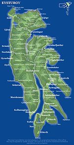
Eysturoy means East island and is the second-largest of the Faroe Islands
in the North Atlantic, both in size and population. It is separated by a narrow sound
from the main island of Streymoy
. Eysturoy is extremely rugged, with some 66 separate mountain peaks
, including Slættaratindur
, the highest peak in the archipelago
. Important towns on Eysturoy are Fuglafjørður
in the north and the densely populated area of the municipalities of Runavík
and Nes
in the south.
Eysturoy is connected with Streymoy via a road bridge
over the sound. This bridge is humorously referred to by islanders as the only bridge over the Atlantic (the natives of the Scottish island of Seil
make the same claim). Leirvík
on the east coast of the island is the gateway for transport connections to the north-eastern islands, particularly Klaksvík
on the island of Borðoy
, which is the Faroes' second-largest town.
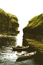
Sites of interest on Eysturoy include the villages of Eiði
and Gjógv
, the latter having a small natural port
in a rock column; the Blásastova historical museum
in the village of Gøta; and the varmakelda (thermal springs) of Fuglafjørður, which indicate the volcanic
origin of the archipelago. Off the northern tip of the island are the basalt
sea stacks Risin og Kellingin
.
Faroe Islands
The Faroe Islands are an island group situated between the Norwegian Sea and the North Atlantic Ocean, approximately halfway between Scotland and Iceland. The Faroe Islands are a self-governing territory within the Kingdom of Denmark, along with Denmark proper and Greenland...
in the North Atlantic, both in size and population. It is separated by a narrow sound
Sound (geography)
In geography a sound or seaway is a large sea or ocean inlet larger than a bay, deeper than a bight and wider than a fjord; or it may be defined as a narrow sea or ocean channel between two bodies of land ....
from the main island of Streymoy
Streymoy
Streymoy is the largest and most populated island of the Faroe Islands. The capital, Tórshavn is located there. The name means "island of currents".- Geography :...
. Eysturoy is extremely rugged, with some 66 separate mountain peaks
Mountain
Image:Himalaya_annotated.jpg|thumb|right|The Himalayan mountain range with Mount Everestrect 58 14 160 49 Chomo Lonzorect 200 28 335 52 Makalurect 378 24 566 45 Mount Everestrect 188 581 920 656 Tibetan Plateaurect 250 406 340 427 Rong River...
, including Slættaratindur
Slættaratindur
Slættaratindur is the highest mountain in the Faroe Islands, at an altitude of 882 metres. It is located in the northern part of Eysturoy, between the villages of Eiði, Gjógv, and Funningur....
, the highest peak in the archipelago
Archipelago
An archipelago , sometimes called an island group, is a chain or cluster of islands. The word archipelago is derived from the Greek ἄρχι- – arkhi- and πέλαγος – pélagos through the Italian arcipelago...
. Important towns on Eysturoy are Fuglafjørður
Fuglafjørður
Fuglafjørður is a village on Eysturoy's east coast in the Faroe Islands. Its name means "fjord of birds".* Population: 1562* Location: * Postal code : FO 530* Municipality: Fuglafjardar* Football team: ÍF Fuglafjørður...
in the north and the densely populated area of the municipalities of Runavík
Runavík
Runavík is a comparatively urbanised village in the Faroe Islands. It lies on the south half of the isle of Eysturoy. The municipality of the same name incorporates 14 settlements including Æðuvík, Rituvík, Saltangará, Glyvrar, Lambi, Lambareiði, Søldarfjørður, Skipanes, Skáli, Skálafjørður,...
and Nes
Nes, Eysturoy
Nes is a Village and Municipality on the southwest coast of the Faroese island of Eysturoy. Beside Nes two other towns Toftir and Saltnes are part of Nes Municipality, which has a total population of 1.267 .-Overview:...
in the south.
Eysturoy is connected with Streymoy via a road bridge
Bridge
A bridge is a structure built to span physical obstacles such as a body of water, valley, or road, for the purpose of providing passage over the obstacle...
over the sound. This bridge is humorously referred to by islanders as the only bridge over the Atlantic (the natives of the Scottish island of Seil
Seil
One of the Slate Islands, Seil is a small island on the east side of the Firth of Lorn, southwest of Oban, in Scotland.Seil has been linked to the Scottish mainland since 1792 when the Clachan Bridge was built by engineer Robert Mylne...
make the same claim). Leirvík
Leirvík
Leirvík is a town on the Faroe Islands and was an important regional ferry harbour at the east coast of the second largest island Eysturoy. Leirvík has 867 inhabitants...
on the east coast of the island is the gateway for transport connections to the north-eastern islands, particularly Klaksvík
Klaksvík
Klaksvík is the second largest town of the Faroe Islands.The town is located on Borðoy, which is one of the northernmost islands ....
on the island of Borðoy
Borðoy
Borðoy is an island in the north-east of the Faroe Islands. There are eight settlements: Klaksvík , Norðoyri, Ánir, Árnafjørður, Strond, Norðtoftir, Depil and Norðdepil. There are also three abandoned settlements: Skálatoftir, Múli and Fossá, all in the north...
, which is the Faroes' second-largest town.
Sites of interest on Eysturoy include the villages of Eiði
Eiði
Eiði is a large village located on the north-west tip of Eysturoy, Faroe Islands Its name means isthmus in the Faroese language. The town has a population of 669In the center of the village there is a large stone church from 1881...
and Gjógv
Gjógv
Gjógv |geo]]) is a village located on the northeast tip of the island of Eysturoy, in the Faroe Islands and 63 km north by road from the capital of Tórshavn...
, the latter having a small natural port
Port
A port is a location on a coast or shore containing one or more harbors where ships can dock and transfer people or cargo to or from land....
in a rock column; the Blásastova historical museum
Museum
A museum is an institution that cares for a collection of artifacts and other objects of scientific, artistic, cultural, or historical importance and makes them available for public viewing through exhibits that may be permanent or temporary. Most large museums are located in major cities...
in the village of Gøta; and the varmakelda (thermal springs) of Fuglafjørður, which indicate the volcanic
Volcano
2. Bedrock3. Conduit 4. Base5. Sill6. Dike7. Layers of ash emitted by the volcano8. Flank| 9. Layers of lava emitted by the volcano10. Throat11. Parasitic cone12. Lava flow13. Vent14. Crater15...
origin of the archipelago. Off the northern tip of the island are the basalt
Basalt
Basalt is a common extrusive volcanic rock. It is usually grey to black and fine-grained due to rapid cooling of lava at the surface of a planet. It may be porphyritic containing larger crystals in a fine matrix, or vesicular, or frothy scoria. Unweathered basalt is black or grey...
sea stacks Risin og Kellingin
Risin og Kellingin
Risin og Kellingin are two sea stacks just off the northern coast of the island of Eysturoy in the Faroe Islands close to the town of Eiði. The name Risin og Kellingin means The Giant and the Witch and relates to an old legend about their origins...
.
 |
 |
Further reading
- Viderö, Kristian Osvald. Saga Eysturoyar. Tórshavn: Bókagarður, 1994.
External links
- Personal website with 15 aerial photos of Eysturoy

