
Tvøroyri
Encyclopedia
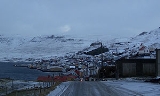
Tvøroyri lies picturesquely on the north side of the Trongisvágsfjørður (fjord
) on the east coast of Suðuroy
, Faroe Islands
.
The ferry Smyril M/F has 2-3 daily departures from Tórshavn
, it calls at Krambatangi
ferry port, which is located on the opposite side of the inlet. The trip from Tórshavn to Tvøroyri takes 2 hours. The ferry is large, it takes 200 cars and 975 persons, and if the weather is nice the trip is beautiful and one can see many islands during the trip. It is possible to go by bus from the harbour of Krambatangi to Tvøroyri and all other villages on the island. There are two buss lines: 700 goes to the southern part of the island with Sumba as its end station, 701 goes to the northern part of the island, the end stations are in Sandvík, the northernmost village, and in Fámjin, which is on the west coast, a bit further south of Krambatangi ferry port is a small village which is called Øravík
, the road to Fámjin
starts there.
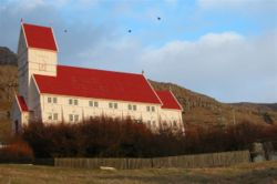
The church in Tvøroyri rises high above the village and can be seen from far away. It was constructed in
Norway
as a building set, moved to Tvøroyri and then built here in 1907. The old church was moved to Sandvík
.
In the centre of Tvøroyri, just above the harbour, is "Hotel Tvøroyri".
Between the harbour and the hotel lies a square covered by flat stones. Fish used to be dried in the sun here. The Royal Trade Monopoly that had a branch here from 1836 to 1856 built the old houses in the area. The village of Tvøroyri was actually founded due to this branch.
When the monopoly was abolished in 1856, private companies were founded on Tvøroyri. One of these grew into the largest in the Faroe Islands. It had 20 branches and 30 ships.
There also lies a museum (History and Maritime Museum of Tvøroyri) in the area above the harbour. Tvøroyri has a large fillet-factory that initiated its production in 1975.
From Tvøroyri one can take a nice walk across the mountains to a valley called Hvannhagi. There is a nice view over the valley and the sea from above the valley. It is also possible to go down into the valley by following the track after the gate.
Tvøroyri has neighbour villages which have grown together with Tvøroyri, which is the central one. Trongisvágur
is further west, it lyes around the fjord, Trongisvágsfjørður, and a bit into the valley Trongisvágsbotnur. The other neighbour village is called Froðba, it is further east on the north side of the fjord, on the same side as Tvøroyri. Froðba
has columnar basalt along the road, a famous poet Poul F. Joensen had his home in Froðba, and there is a monument there to honour him. Froðba and Trongisvágur are older villages than Tvøroyri.
Tvøroyri and Vágur
take turns in hosting an annual civic-festival called Jóansøka. It can be described as a smaller version of the Ólavsøka
held in Tórshavn. Jóansøka runs in late June.
Tvøroyri is the birth place of former Faroese
Prime Ministers, Jóannes Eidesgaard
, Atli Dam
and Pætur Mohr Dam.
Fjord
Geologically, a fjord is a long, narrow inlet with steep sides or cliffs, created in a valley carved by glacial activity.-Formation:A fjord is formed when a glacier cuts a U-shaped valley by abrasion of the surrounding bedrock. Glacial melting is accompanied by rebound of Earth's crust as the ice...
) on the east coast of Suðuroy
Suðuroy
Suðuroy is the southernmost of the Faroe Islands. The island covers 163.7 km². In 2010 there were 4763 inhabitants, but there has been a gradual decline in the population numbers ever since the 1950s....
, Faroe Islands
Faroe Islands
The Faroe Islands are an island group situated between the Norwegian Sea and the North Atlantic Ocean, approximately halfway between Scotland and Iceland. The Faroe Islands are a self-governing territory within the Kingdom of Denmark, along with Denmark proper and Greenland...
.
The ferry Smyril M/F has 2-3 daily departures from Tórshavn
Tórshavn
Tórshavn is the capital and largest town of the Faroe Islands. It is located in the southern part on the east coast of Streymoy. To the north west of the town lies the high mountain Húsareyn, and to the southwest, the high Kirkjubøreyn...
, it calls at Krambatangi
Krambatangi
Krambatangi is the ferry port of Suðuroy in the Faroe Islands. The ferry Smyril M/F disembarks 2-3 times daily from Krambatangi to Tórshavn. Krambatangi is located on the southern side of Trongisvágsfjørður halfway between Trongisvágur and Øravík, opposite of Tvøroyri. The ferry port was earlier on...
ferry port, which is located on the opposite side of the inlet. The trip from Tórshavn to Tvøroyri takes 2 hours. The ferry is large, it takes 200 cars and 975 persons, and if the weather is nice the trip is beautiful and one can see many islands during the trip. It is possible to go by bus from the harbour of Krambatangi to Tvøroyri and all other villages on the island. There are two buss lines: 700 goes to the southern part of the island with Sumba as its end station, 701 goes to the northern part of the island, the end stations are in Sandvík, the northernmost village, and in Fámjin, which is on the west coast, a bit further south of Krambatangi ferry port is a small village which is called Øravík
Øravík
Øravík is a village on the east coast of the island of Suðuroy in the Faroe Islands. The village is located in the center of the island on a crossroad where the road to Fámjin goes towards west over the mountains to the west coast. One part of the village is located in the bay of Øravík, the other...
, the road to Fámjin
Fámjin
Fámjin is a village, located in the middle of the coastline on the western side of Suðuroy, the southernmost island in Faroe Islands. It has a population of around 100....
starts there.
The church in Tvøroyri rises high above the village and can be seen from far away. It was constructed in
Norway
Norway
Norway , officially the Kingdom of Norway, is a Nordic unitary constitutional monarchy whose territory comprises the western portion of the Scandinavian Peninsula, Jan Mayen, and the Arctic archipelago of Svalbard and Bouvet Island. Norway has a total area of and a population of about 4.9 million...
as a building set, moved to Tvøroyri and then built here in 1907. The old church was moved to Sandvík
Sandvík
Sandvík is the northernmost village of the island of Suðuroy in the Faroe Islands. It is situated on the northern side of a shallow fjord. The small village was earlier known as Hvalvík until 1913...
.
In the centre of Tvøroyri, just above the harbour, is "Hotel Tvøroyri".
Between the harbour and the hotel lies a square covered by flat stones. Fish used to be dried in the sun here. The Royal Trade Monopoly that had a branch here from 1836 to 1856 built the old houses in the area. The village of Tvøroyri was actually founded due to this branch.
When the monopoly was abolished in 1856, private companies were founded on Tvøroyri. One of these grew into the largest in the Faroe Islands. It had 20 branches and 30 ships.
There also lies a museum (History and Maritime Museum of Tvøroyri) in the area above the harbour. Tvøroyri has a large fillet-factory that initiated its production in 1975.
From Tvøroyri one can take a nice walk across the mountains to a valley called Hvannhagi. There is a nice view over the valley and the sea from above the valley. It is also possible to go down into the valley by following the track after the gate.
Tvøroyri has neighbour villages which have grown together with Tvøroyri, which is the central one. Trongisvágur
Trongisvágur
Trongisvágur is a village on the island of Suduroy in the Faroe Islands.*Population: 415*Postal code : FO 826*Location: *Municipality: Tvoroyrar...
is further west, it lyes around the fjord, Trongisvágsfjørður, and a bit into the valley Trongisvágsbotnur. The other neighbour village is called Froðba, it is further east on the north side of the fjord, on the same side as Tvøroyri. Froðba
Froðba
Froðba is a village located farthest out on the north brink of Trongisvágsfjørður, an inlet on the east coast of the island of Suðuroy in the Faroe Islands. The village has eventually merged with the harbour-city of Tvøroyri....
has columnar basalt along the road, a famous poet Poul F. Joensen had his home in Froðba, and there is a monument there to honour him. Froðba and Trongisvágur are older villages than Tvøroyri.
Tvøroyri and Vágur
Vágur
Vágur meaning Bay is a town on the Faroe Islands of Suðuroy, it is situated on the east coast of the island on the Vágsfjørður fjord, and dates from the fourteenth century. Expansion has meant that the nearby town of Nes is now a suburb of Vágur...
take turns in hosting an annual civic-festival called Jóansøka. It can be described as a smaller version of the Ólavsøka
Ólavsøka
Ólavsøka is a national holiday of the Faroe Islands, celebrated on July 29. It is the day when Løgting, the Faroese Parliament, opens its session....
held in Tórshavn. Jóansøka runs in late June.
Tvøroyri is the birth place of former Faroese
Faroe Islands
The Faroe Islands are an island group situated between the Norwegian Sea and the North Atlantic Ocean, approximately halfway between Scotland and Iceland. The Faroe Islands are a self-governing territory within the Kingdom of Denmark, along with Denmark proper and Greenland...
Prime Ministers, Jóannes Eidesgaard
Jóannes Eidesgaard
Jóannes Dan Eidesgaard is the Finance Minister of the Faroe Islands. He has held the position since 26 September 2008. He previously served as Prime Minister of the Faeroe Islands from 3 February 2004, shortly after the general election of 20 January 2004, until 26 September 2008, when a new...
, Atli Dam
Atli Dam
Atli Pæturssonur Dam was Prime Minister of the Faroe Islands on five separate occasions....
and Pætur Mohr Dam.
- Football club: TB TvøroyriTB TvøroyriTvøroyrar Bóltfelag is a Faroese football club from Tvøroyri, currently playing in the second tier of Faroese football.TB Tvøroyri is the oldest football club in the Faroe Islands and also one of the oldest in Denmark where the islands officially belong to....
, founded in 1892, the oldest in the Faroe Islands. - Rowing club: Froðbiar Sóknar Róðrarfelag, founded in 1934.
External links
- Faroeislands.dk: Tvøroyri Images and description of all cities on the Faroe Islands.
- The Municipality of Tvøroyri
- TB - The Football Club of Tvøroyri
- The Tourist Information Center of Tvøroyri and Suðuroy
- Photo gallery
- Painting Courses in Tvøroyri and Suðuroy
- Art Gallery Oyggin