
Tonto Trail
Encyclopedia
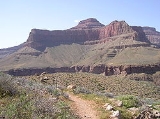
The Tonto Trail is a hiking
trail
on the South Rim of the Grand Canyon
in Grand Canyon National Park
, located in the U.S. state
of Arizona
.
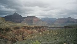
at Garnet Canyon (western end) and ends at Red Canyon (eastern end), also at the Colorado River. Through most of its 70 mile length, the trail runs along the Tonto Platform, the bench in the Grand Canyon that separates the inner gorge from the upper canyon.
 Tonto crosses the South Bass Trail
, Boucher Trail
, Hermit Trail
, Bright Angel Trail
, South Kaibab Trail
and the New Hance Trail
. The Grandview Trail
is also accessible via its eastern and western spurs. All of the connecting trails provide access to and from the Grand Canyon south rim, while the Bright Angel Trail and South Kaibab Trail both provide access to the Colorado River, and the north rim via the North Kaibab Trail
.
At Garnet Canyon, the Tonto Trail officially ends, but a trail continues along the Colorado River to Elves Chasm. There is also a junction with the Royal Arch Route
, which requires a rappel from to access the river trail. At Red Canyon, the eastern end of the Tonto Trail, the Escalante Route
continues eastward, connecting to the Tanner Trail
and Beamer Trail
at Unkar Creek.
There is additional access to the Colorado River in Monument Canyon via a 1½ mile spur trail that leads to Granite Rapids. There is a designated campsite at the river. There is also access to the river via all trails that cross the Tonto, except the Grandview Trail.
 Trail conditions vary based on the amount of traffic certain sections receive. The section between the Bright Angel Trail and the South Kaibab Trail (4.6 miles, 7.4 kilometres) is the most heavily travelled and the easiest to follow. Less travelled sections are subject to overgrowth by canyon flora early in the spring season, and may require route finding skills to traverse.
Hermit Creek, Monument Creek, and Garden Creek flow year round and can be consumed after purification. Water from Horn Creek should be avoided except in extreme life-and-death circumstances due to high radioactive contamination
from the Lost Orphan Uranium
Mine (defunct) below Powell Point.
The park's Backcountry Information Center has current water conditions for all water sources along the Tonto Trail.
, and they call for a maximum number of groups (7 to 11 people) and parties (1 to 6 people), as well as a maximum total number of persons.
The Tonto Trail passes through numerous backcountry use areas. The three letter code indicates the park's use area designation (listed from east to west):
Use permits are available on a first-come, first-serve basis from the park's Backcountry Information Center. Requests are taken beginning on the 1st day of the month, up to four month's before the requested first night of camping.
, sudden rainstorms, flash flooding, loose footing, rockfall, encounters with wildlife, and extreme heat. At the Colorado River, additional hazards include hypothermia
(due to the river's consistently cold temperatures), trauma
(due to collisions with boulders in rapids), and drowning
.
Hikers who venture east of the South Kaibab Trail or west of the Hermit Trail are more likely to find solitude and isolation in addition to other hazards related to desert hiking.
Hiking
Hiking is an outdoor activity which consists of walking in natural environments, often in mountainous or other scenic terrain. People often hike on hiking trails. It is such a popular activity that there are numerous hiking organizations worldwide. The health benefits of different types of hiking...
trail
Trail
A trail is a path with a rough beaten or dirt/stone surface used for travel. Trails may be for use only by walkers and in some places are the main access route to remote settlements...
on the South Rim of the Grand Canyon
Grand Canyon
The Grand Canyon is a steep-sided canyon carved by the Colorado River in the United States in the state of Arizona. It is largely contained within the Grand Canyon National Park, the 15th national park in the United States...
in Grand Canyon National Park
Grand Canyon National Park
Grand Canyon National Park is the United States' 15th oldest national park and is located in Arizona. Within the park lies the Grand Canyon, a gorge of the Colorado River, considered to be one of the Wonders of the World. The park covers of unincorporated area in Coconino and Mohave counties.Most...
, located in the U.S. state
U.S. state
A U.S. state is any one of the 50 federated states of the United States of America that share sovereignty with the federal government. Because of this shared sovereignty, an American is a citizen both of the federal entity and of his or her state of domicile. Four states use the official title of...
of Arizona
Arizona
Arizona ; is a state located in the southwestern region of the United States. It is also part of the western United States and the mountain west. The capital and largest city is Phoenix...
.
Access
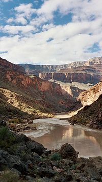
The Tonto Trail does not terminate at either rim of the Grand Canyon, but begins along the south bank of the Colorado RiverColorado River
The Colorado River , is a river in the Southwestern United States and northwestern Mexico, approximately long, draining a part of the arid regions on the western slope of the Rocky Mountains. The watershed of the Colorado River covers in parts of seven U.S. states and two Mexican states...
at Garnet Canyon (western end) and ends at Red Canyon (eastern end), also at the Colorado River. Through most of its 70 mile length, the trail runs along the Tonto Platform, the bench in the Grand Canyon that separates the inner gorge from the upper canyon.
Description
South Bass Trail
The South Bass Trail is a hiking trail located on the South Rim of the Grand Canyon National Park, located in the U.S. state of Arizona.-Access:...
, Boucher Trail
Boucher Trail
The Boucher Trail is a hiking trail in Grand Canyon National Park, located in the U.S. state of Arizona.-Access:The trail officially begins at a low point on the Dripping Springs Trail, in the southwest part of Hermit Canyon. Access to the Boucher Trail requires a hike of about 2¾ miles along the...
, Hermit Trail
Hermit Trail
The Hermit Trail is a hiking trail in Grand Canyon National Park, located in the U.S. state of Arizona. This trail provides access to a historic area of Grand Canyon and offers a more challenging route to the Colorado River for more experienced canyon hikers....
, Bright Angel Trail
Bright Angel Trail
The Bright Angel Trail is a hiking trail located in Grand Canyon National Park in the U.S. state of Arizona.-Access:The trail is accessed by the mule corral, as seen here:-Description:...
, South Kaibab Trail
South Kaibab Trail
The South Kaibab Trail is a hiking trail in Grand Canyon National Park, located in the U.S. state of Arizona. Unlike the Bright Angel Trail which also begins at the south rim of Grand Canyon and leads to the Colorado River, the South Kaibab Trail follows a ridge out to Skeleton Point allowing for...
and the New Hance Trail
New Hance Trail
The New Hance Trail is a hiking trail on the South Rim of the Grand Canyon National Park, located in the U.S. state of Arizona...
. The Grandview Trail
Grandview Trail
The Grandview Trail is a hiking trail located on the South Rim of the Grand Canyon National Park, located in the U.S. state of Arizona.-Description:...
is also accessible via its eastern and western spurs. All of the connecting trails provide access to and from the Grand Canyon south rim, while the Bright Angel Trail and South Kaibab Trail both provide access to the Colorado River, and the north rim via the North Kaibab Trail
North Kaibab Trail
The North Kaibab Trail is a hiking trail in Grand Canyon National Park, located in the U.S. state of Arizona.-Access:Access to this part of the park by car is seasonal, open from mid-May to mid-October or depending on snowcover from the previous winter...
.
At Garnet Canyon, the Tonto Trail officially ends, but a trail continues along the Colorado River to Elves Chasm. There is also a junction with the Royal Arch Route
Royal Arch Route
The Royal Arch Route is a hiking trail on the South Rim of the Grand Canyon National Park, located in the U.S. state of Arizona.-External links:* *...
, which requires a rappel from to access the river trail. At Red Canyon, the eastern end of the Tonto Trail, the Escalante Route
Escalante Route
The Escalante Route is a hiking trail on the South Rim of the Grand Canyon National Park, located in the U.S. state of Arizona. It starts near the Tanner Rapids on the Colorado River and follows the river...
continues eastward, connecting to the Tanner Trail
Tanner Trail
The Tanner Trail is a hiking trail located on the South Rim of the Grand Canyon National Park, located in the U.S. state of Arizona. The trailhead is located at Lipan Point, a prominent lookout located to the east of the Grand Canyon Village and it ends at the Colorado River at Tanner Rapids.With...
and Beamer Trail
Beamer Trail
The Beamer Trail is a backpacking trail located on the South Rim of the Grand Canyon National Park, located in the U.S. state of Arizona.-Description:...
at Unkar Creek.
There is additional access to the Colorado River in Monument Canyon via a 1½ mile spur trail that leads to Granite Rapids. There is a designated campsite at the river. There is also access to the river via all trails that cross the Tonto, except the Grandview Trail.
Condition
Water availability
All water sources along this trail must be treated, filtered, or boiled before drinking, with the exception of water available at the junction with the Bright Angel Trail (at Indian Garden).Hermit Creek, Monument Creek, and Garden Creek flow year round and can be consumed after purification. Water from Horn Creek should be avoided except in extreme life-and-death circumstances due to high radioactive contamination
Radioactive contamination
Radioactive contamination, also called radiological contamination, is radioactive substances on surfaces, or within solids, liquids or gases , where their presence is unintended or undesirable, or the process giving rise to their presence in such places...
from the Lost Orphan Uranium
Uranium
Uranium is a silvery-white metallic chemical element in the actinide series of the periodic table, with atomic number 92. It is assigned the chemical symbol U. A uranium atom has 92 protons and 92 electrons, of which 6 are valence electrons...
Mine (defunct) below Powell Point.
The park's Backcountry Information Center has current water conditions for all water sources along the Tonto Trail.
Camping
Camping is allowed along the Tonto Trail by permit only, issued by the Grand Canyon National Park Backcountry Information Center. Use of these areas overnight are regulated by the National Park ServiceNational Park Service
The National Park Service is the U.S. federal agency that manages all national parks, many national monuments, and other conservation and historical properties with various title designations...
, and they call for a maximum number of groups (7 to 11 people) and parties (1 to 6 people), as well as a maximum total number of persons.
The Tonto Trail passes through numerous backcountry use areas. The three letter code indicates the park's use area designation (listed from east to west):
| Area | Name | Type | Group(s) | Parties | Max People | |
|---|---|---|---|---|---|---|
| BD9 | Red Canyon | At-large | 1 | and | 2 | 23 |
| BE9 | Hance Creek | At-large | 1 | and | 2 | 23 |
| BG9 | Cottonwood Creek | At-large | 1 | and | 2 | 23 |
| BH9 | Grapevine | At-large | 1 | and | 2 | 23 |
| BJ9 | Cremation | At-large | 1 | and | 2 | 23 |
| CIG | Indian Garden | Campground | 1 | and | 15 | 50 |
| BL4 | Horn Creek | Campsite | 0 | 1 | 6 | |
| BL5 | Salt Creek | Campsite | 0 | 1 | 6 | |
| BL6 | Cedar Spring | Campsite | 0 | 1 | 6 | |
| BL7 | Monument Creek | Campsite | 1 | and | 2 | 23 |
| BL8 | Granite Rapids | Campsite | 1 | and | 2 | 23 |
| BM7 | Hermit Creek | Campsite | 1 | and | 3 | 29 |
| BM8 | Hermit Rapids | Campsite | 1 | and | 1 | 17 |
| BN9 | Boucher | At-large | 1 | and | 2 | 23 |
| BO9 | Slate | At-large | 1 | and | 2 | 23 |
| BP9 | Ruby | At-large | 1 | and | 2 | 23 |
| BQ9 | South Bass | At-large | 1 | and | 2 | 23 |
| BR9 | Garnet | At-large | 1 | and | 2 | 23 |
Use permits are available on a first-come, first-serve basis from the park's Backcountry Information Center. Requests are taken beginning on the 1st day of the month, up to four month's before the requested first night of camping.
Hazards
Hazards hikers can encounter along the Tonto Trail include dehydrationDehydration
In physiology and medicine, dehydration is defined as the excessive loss of body fluid. It is literally the removal of water from an object; however, in physiological terms, it entails a deficiency of fluid within an organism...
, sudden rainstorms, flash flooding, loose footing, rockfall, encounters with wildlife, and extreme heat. At the Colorado River, additional hazards include hypothermia
Hypothermia
Hypothermia is a condition in which core temperature drops below the required temperature for normal metabolism and body functions which is defined as . Body temperature is usually maintained near a constant level of through biologic homeostasis or thermoregulation...
(due to the river's consistently cold temperatures), trauma
Physical trauma
Trauma refers to "a body wound or shock produced by sudden physical injury, as from violence or accident." It can also be described as "a physical wound or injury, such as a fracture or blow." Major trauma can result in secondary complications such as circulatory shock, respiratory failure and death...
(due to collisions with boulders in rapids), and drowning
Drowning
Drowning is death from asphyxia due to suffocation caused by water entering the lungs and preventing the absorption of oxygen leading to cerebral hypoxia....
.
Hikers who venture east of the South Kaibab Trail or west of the Hermit Trail are more likely to find solitude and isolation in addition to other hazards related to desert hiking.