
Tanner Trail
Encyclopedia
The Tanner Trail is a hiking
trail
located on the South Rim of the Grand Canyon National Park
, located in the U.S. state
of Arizona
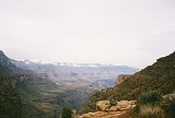
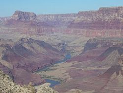
. The trailhead is located at Lipan Point, a prominent lookout located to the east of the Grand Canyon Village and it ends at the Colorado River at Tanner Rapids.
With its length, difficulty level, remoteness, and rewarding views, the Tanner Trail has become a popular destination for tourist and backpacker alike.
route to the Colorado River
. Most believe today that Tanner Canyon is where Garcia Lopez de Cardenas
became the first European to encounter the Grand Canyon
. The trail is named after Seth Tanner
, a 19th century prospector who improved the trail so he would have better access to his copper
mine
. It is also believed that Tanner Canyon was once used as an old horse thief trail where buried gold known as Long Tom's treasure
is located. The horse thieves would use the canyon to bring the horses from Arizona into Utah
. While in the canyon, the horse thieves would change the brands of the horses, then they would cross the Colorado River and drive the horses out of the canyon through the Nankoweap Trail
up onto the North Rim. The canyon was once named Horsethief Canyon in honor of this storied past.
. The trailhead for the Tanner Trail is located near the parking area at Lipan Point, which can be accessed by the Desert View Drive
. Hikers are advised to park at Lipan Point, as the trailhead is located just before the parking lot at Lipan Point.
 The Tanner trailhead begins at the information sign just before Lipan Point. The trail starts out by crossing the rim plateau to the canyon edge. It then enters the Tanner Canyon and starts a series of switchbacks, which become very steep and rocky. The descent is considered to be one of the steepest rim descents in the Grand Canyon. The trail goes through the Kaibab Formation and becomes even steeper in the Coconino sandstone and the Hermit shale. It finally reaches the Supai group, where the ridge between Tanner Canyon and Seventyfive Mile Canyon is located.
The trail then enters into the Tanner Canyon creek for a short time, then it leaves the creek. It then makes a long yet moderate crossing of the Supai group. There are many suitable campsites along this stretch, while it passes Escalante and then Cardenas Buttes. The trail passes below these buttes and descends into a boulder-strewn plateau. It then turns to the north to the end of the plateau.
At this point the trail makes its second major descent, dropping off the plateau into the lower Tanner Canyon. There are some switchbacks yet the trail mainly descends straight down around 800 ft (243.8 m) to a red saddle below where there are a few campsites. From the saddle, the trail levels out, although there is still a gradual rate of descent. The trail follows the west side of Tanner Canyon, slowly descending to the streambed below. When the streambed is reached, the trail crosses over to the east side and up onto the river plateau. It crosses this small plateau and drops into the campground. Campsites can be found to the east and the west (Pgs 79-86).
s. All water in the Grand Canyon must be treated before consumption. The National Park Service
recommends boiling, iodine tablets, or filters in order to purify the water. If water is taken from the Colorado River, the Park recommends letting the water sit so the sediment will settle.
.
 Hazards hikers can encounter along the Tanner Trail include dehydration
, heat stroke, exhaustion, sudden rainstorms, flash flooding, loose footing, rockfall, encounters with wildlife, extreme heat, and getting lost. At the Colorado River, additional hazards include hypothermia
(due to the river's consistently cold temperatures), trauma
(due to collisions with boulders in rapids), and drowning
. Extreme care, caution, and preparation should always be used when entering the Grand Canyon.
Hikers also need to remember that the Grand Canyon is located in the desert, and as such there are many dangerous desert species to watch out for. These include all types of scorpion
s, snakes, spider
s, centipede
s, mice
, deer
, big horn sheep, and mountain lions. The most dangerous and venomous of these animals are the black widow spider
, the Arizona bark scorpion
, and the rattlesnake
(Pgs 44-45).
Hiking
Hiking is an outdoor activity which consists of walking in natural environments, often in mountainous or other scenic terrain. People often hike on hiking trails. It is such a popular activity that there are numerous hiking organizations worldwide. The health benefits of different types of hiking...
trail
Trail
A trail is a path with a rough beaten or dirt/stone surface used for travel. Trails may be for use only by walkers and in some places are the main access route to remote settlements...
located on the South Rim of the Grand Canyon National Park
Grand Canyon National Park
Grand Canyon National Park is the United States' 15th oldest national park and is located in Arizona. Within the park lies the Grand Canyon, a gorge of the Colorado River, considered to be one of the Wonders of the World. The park covers of unincorporated area in Coconino and Mohave counties.Most...
, located in the U.S. state
U.S. state
A U.S. state is any one of the 50 federated states of the United States of America that share sovereignty with the federal government. Because of this shared sovereignty, an American is a citizen both of the federal entity and of his or her state of domicile. Four states use the official title of...
of Arizona
Arizona
Arizona ; is a state located in the southwestern region of the United States. It is also part of the western United States and the mountain west. The capital and largest city is Phoenix...
. The trailhead is located at Lipan Point, a prominent lookout located to the east of the Grand Canyon Village and it ends at the Colorado River at Tanner Rapids.
With its length, difficulty level, remoteness, and rewarding views, the Tanner Trail has become a popular destination for tourist and backpacker alike.
History
The Tanner Trail started out as an ancient Anasazi and HopiHopi
The Hopi are a federally recognized tribe of indigenous Native American people, who primarily live on the Hopi Reservation in northeastern Arizona. The Hopi area according to the 2000 census has a population of 6,946 people. Their Hopi language is one of the 30 of the Uto-Aztecan language...
route to the Colorado River
Colorado River
The Colorado River , is a river in the Southwestern United States and northwestern Mexico, approximately long, draining a part of the arid regions on the western slope of the Rocky Mountains. The watershed of the Colorado River covers in parts of seven U.S. states and two Mexican states...
. Most believe today that Tanner Canyon is where Garcia Lopez de Cardenas
García López de Cárdenas
García López de Cárdenas, , is credited with the first European discovery of the Grand Canyon.- Life :Cárdenas was born in Llerena, Spain, son to Alonso de Cárdenas y doña Elvira de Figueroa and Maria García Osorio. He was the comendador of Caravaca.López de Cárdenas was conquistador attached to...
became the first European to encounter the Grand Canyon
Grand Canyon
The Grand Canyon is a steep-sided canyon carved by the Colorado River in the United States in the state of Arizona. It is largely contained within the Grand Canyon National Park, the 15th national park in the United States...
. The trail is named after Seth Tanner
Seth Tanner
Seth Tanner was a Mormon settler who established the Tanner Trail in the Grand Canyon National Park.-Life:Seth's full name was Seth Benjamin Tanner. He was one of John Tanner's 21 children. He was born in Bolton, New York, and was with his father's family as they were driven across the U.S. from...
, a 19th century prospector who improved the trail so he would have better access to his copper
Copper
Copper is a chemical element with the symbol Cu and atomic number 29. It is a ductile metal with very high thermal and electrical conductivity. Pure copper is soft and malleable; an exposed surface has a reddish-orange tarnish...
mine
Mining
Mining is the extraction of valuable minerals or other geological materials from the earth, from an ore body, vein or seam. The term also includes the removal of soil. Materials recovered by mining include base metals, precious metals, iron, uranium, coal, diamonds, limestone, oil shale, rock...
. It is also believed that Tanner Canyon was once used as an old horse thief trail where buried gold known as Long Tom's treasure
Long Tom's treasure
Long Tom's treasure is a legend in American folklore said to have taken place in the Grand Canyon of Arizona, four miles west of the Tanner immigrant trail, near a Havasupai village....
is located. The horse thieves would use the canyon to bring the horses from Arizona into Utah
Utah
Utah is a state in the Western United States. It was the 45th state to join the Union, on January 4, 1896. Approximately 80% of Utah's 2,763,885 people live along the Wasatch Front, centering on Salt Lake City. This leaves vast expanses of the state nearly uninhabited, making the population the...
. While in the canyon, the horse thieves would change the brands of the horses, then they would cross the Colorado River and drive the horses out of the canyon through the Nankoweap Trail
Nankoweap Trail
The Nankoweap Trail is a hiking trail on the North Rim of the Grand Canyon National Park, located in the U.S. state of Arizona.The Nankoweap trail descends 6,040 feet in 14 miles from the Saddle Mountain trailhead to Nankoweap Creek and on to the Colorado River. It is considered to be the hardest...
up onto the North Rim. The canyon was once named Horsethief Canyon in honor of this storied past.
Access
Entrance to the South Rim of the Grand Canyon can be accessed by two points: the south entrance via State Route 64 north from Williams, and the east entrance via State Route 64 west from U.S. Route 89U.S. Route 89 in Arizona
In the U.S. state of Arizona, U.S. Route 89 is a U.S. Highway that begins in Flagstaff and heads north to the Utah border northwest of Page.-Route description:...
. The trailhead for the Tanner Trail is located near the parking area at Lipan Point, which can be accessed by the Desert View Drive
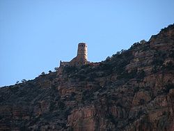
Desert View Drive
The Desert View Drive is a scenic road located on the South Rim of the Grand Canyon. The road runs from the Grand Canyon Village to Route 64 , passing by many scenic points and trails. The road is named after the Desert View Watchtower....
. Hikers are advised to park at Lipan Point, as the trailhead is located just before the parking lot at Lipan Point.
Description
The trail then enters into the Tanner Canyon creek for a short time, then it leaves the creek. It then makes a long yet moderate crossing of the Supai group. There are many suitable campsites along this stretch, while it passes Escalante and then Cardenas Buttes. The trail passes below these buttes and descends into a boulder-strewn plateau. It then turns to the north to the end of the plateau.
At this point the trail makes its second major descent, dropping off the plateau into the lower Tanner Canyon. There are some switchbacks yet the trail mainly descends straight down around 800 ft (243.8 m) to a red saddle below where there are a few campsites. From the saddle, the trail levels out, although there is still a gradual rate of descent. The trail follows the west side of Tanner Canyon, slowly descending to the streambed below. When the streambed is reached, the trail crosses over to the east side and up onto the river plateau. It crosses this small plateau and drops into the campground. Campsites can be found to the east and the west (Pgs 79-86).
| Distance (mi) | Elv (ft) | Location | Trail Junction |
|---|---|---|---|
| 0 | 7400 | Lipan Point, South Rim | Trailhead |
| 1.9 | 5660 | 75 Mile Saddle | None |
| 3.5 | 5700 | Below Cardenas Butte | None |
| 9 | 2650 | Tanner Campgrounds | Beamer Trail Beamer Trail The Beamer Trail is a backpacking trail located on the South Rim of the Grand Canyon National Park, located in the U.S. state of Arizona.-Description:... Escalante Route Escalante Route The Escalante Route is a hiking trail on the South Rim of the Grand Canyon National Park, located in the U.S. state of Arizona. It starts near the Tanner Rapids on the Colorado River and follows the river... |
Condition
The trail is categorized as a primitive trail and receives little maintenance by trail crews and very few patrols by park rangers. This trail is only recommended for seasoned hikers, as it is very steep, rocky, has very little shade, and the only water source is the Colorado River. The trail is fairly well worn, and mostly easy to follow, although it is one of the longer trails in the Canyon. Extreme care and preparation should always be taken in attempting a trail in the Grand Canyon (Pg. 79).Water availability
The only reliable source of water along the Tanner Trail is the Colorado River. Seasonal water may be found in the Tanner Canyon. Hikers can check with the Backcountry Information Center for updates on all seasonal water sources, which are regularly checked by other hikers and Park rangerPark ranger
A park ranger or forest ranger is a person entrusted with protecting and preserving parklands – national, state, provincial, or local parks. Different countries use different names for the position. Ranger is the favored term in the United States, Canada, and the United Kingdom. Within the United...
s. All water in the Grand Canyon must be treated before consumption. The National Park Service
National Park Service
The National Park Service is the U.S. federal agency that manages all national parks, many national monuments, and other conservation and historical properties with various title designations...
recommends boiling, iodine tablets, or filters in order to purify the water. If water is taken from the Colorado River, the Park recommends letting the water sit so the sediment will settle.
Camping
Camping in the Tanner Trail area is at-large. There are multiple "campsites" along the trail, but the main camp area is located at Tanner Rapids, a spot that is popular to rafters. The camp area is located at the end of the Trail, situated between the dunes to west and the river to the east. The camp area has a pit toilet located in the middle of the campsites. The sand dunes to west are off-limits to camping and foot-travel, as the Park is attempting to revegetate and stabilize the area (Pg. 85).
| Area | Name | Type | Group(s) | Parties | Max People | |
|---|---|---|---|---|---|---|
| BB9 | Tanner Rapids | Primitive | 1 | and | 3 | 29 |
Hazards
Dehydration
In physiology and medicine, dehydration is defined as the excessive loss of body fluid. It is literally the removal of water from an object; however, in physiological terms, it entails a deficiency of fluid within an organism...
, heat stroke, exhaustion, sudden rainstorms, flash flooding, loose footing, rockfall, encounters with wildlife, extreme heat, and getting lost. At the Colorado River, additional hazards include hypothermia
Hypothermia
Hypothermia is a condition in which core temperature drops below the required temperature for normal metabolism and body functions which is defined as . Body temperature is usually maintained near a constant level of through biologic homeostasis or thermoregulation...
(due to the river's consistently cold temperatures), trauma
Physical trauma
Trauma refers to "a body wound or shock produced by sudden physical injury, as from violence or accident." It can also be described as "a physical wound or injury, such as a fracture or blow." Major trauma can result in secondary complications such as circulatory shock, respiratory failure and death...
(due to collisions with boulders in rapids), and drowning
Drowning
Drowning is death from asphyxia due to suffocation caused by water entering the lungs and preventing the absorption of oxygen leading to cerebral hypoxia....
. Extreme care, caution, and preparation should always be used when entering the Grand Canyon.
Hikers also need to remember that the Grand Canyon is located in the desert, and as such there are many dangerous desert species to watch out for. These include all types of scorpion
Scorpion
Scorpions are predatory arthropod animals of the order Scorpiones within the class Arachnida. They have eight legs and are easily recognized by the pair of grasping claws and the narrow, segmented tail, often carried in a characteristic forward curve over the back, ending with a venomous stinger...
s, snakes, spider
Spider
Spiders are air-breathing arthropods that have eight legs, and chelicerae with fangs that inject venom. They are the largest order of arachnids and rank seventh in total species diversity among all other groups of organisms...
s, centipede
Centipede
Centipedes are arthropods belonging to the class Chilopoda of the subphylum Myriapoda. They are elongated metameric animals with one pair of legs per body segment. Despite the name, centipedes can have a varying number of legs from under 20 to over 300. Centipedes have an odd number of pairs of...
s, mice
MICE
-Fiction:*Mice , alien species in The Hitchhiker's Guide to the Galaxy*The Mice -Acronyms:* "Meetings, Incentives, Conferencing, Exhibitions", facilities terminology for events...
, deer
Deer
Deer are the ruminant mammals forming the family Cervidae. Species in the Cervidae family include white-tailed deer, elk, moose, red deer, reindeer, fallow deer, roe deer and chital. Male deer of all species and female reindeer grow and shed new antlers each year...
, big horn sheep, and mountain lions. The most dangerous and venomous of these animals are the black widow spider
Black widow spider
Latrodectus mactans, the Southern black widow, is a highly venomous species of spider in the genus Latrodectus. They are well known for the distinctive black and red coloring of the female of the species and for the fact that she will occasionally eat her mate after reproduction. The species is...
, the Arizona bark scorpion
Arizona bark scorpion
The Arizona bark scorpion , is a small light brown scorpion common to the southwest United States. The range of the scorpion is the Sonoran Desert...
, and the rattlesnake
Rattlesnake
Rattlesnakes are a group of venomous snakes of the genera Crotalus and Sistrurus of the subfamily Crotalinae . There are 32 known species of rattlesnake, with between 65-70 subspecies, all native to the Americas, ranging from southern Alberta and southern British Columbia in Canada to Central...
(Pgs 44-45).