
Bright Angel Trail
Encyclopedia
The Bright Angel Trail is a hiking
trail
located in Grand Canyon National Park
in the U.S.
state of Arizona
.
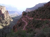
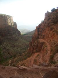
The trail originates on the south rim of Grand Canyon
and descends 4380 feet in elevation to the Colorado River
. It has an average grade of 10% along its entire length. At trail's end, the River Trail
continues another 2 miles to the Bright Angel Campground and Phantom Ranch
. These two trails combined are the most common method used to access Phantom Ranch
by hikers and mules.
There are two trails that cross or join this trail. The first being the Tonto Trail
at Indian Gardens which leads towards the Monument Use Area to the west (the east leads to the South Kaibab Trail
4.7 miles (7.6 km) from the junction), and the River Trail
which officially begins when the Bright Angel Trail reaches the Colorado River
at the River Resthouse, although some consider that the Bright Angel Trail officially ends after crossing the Colorado River at the Silver Bridge.
categorizes the Bright Angel Trail as a corridor trail. With this designation it receives regular maintenance and patrols by park rangers.
Below Indian Gardens, both Garden Creek and Pipe Creek flow year-round (perennial). Water is also available at the River Resthouse from the Colorado River
. All water from natural sources must be filtered, treated, or boiled prior to consuming.
Use permits are available on a first-come, first-serve basis from the park's Backcountry Information Center. Requests are taken beginning on the 1st day of the month, up to four months before the requested first night of camping.
 Hazards hikers can encounter along the Bright Angel Trail include dehydration
, sudden rainstorms, flash flood
ing, loose footing, bootpacked ice, rockfall
, encounters with wildlife
, and extreme heat. At the Colorado River
, additional hazards include hypothermia
(due to the river's consistently cold temperatures), trauma
(due to collisions with boulders in rapids), and drowning
.
Also, the trail is used by the mules to ride to the bottom of the canyon. These mule
s are highly trained
however the trail is not wide enough in some spots for a person and a mule; however, in many places there are areas for hikers and other travelers to seek temporary refuge from the mules. The trail also has many switchbacks, and a bad fall can result in serious injuries. Also, according to the mule tour guides for Xanterra, squirrel
bites at Plateau Point are the leading cause of infirmary visits by hikers and mule riders. Feeding the squirrels is strictly prohibited and highly discouraged.
tribe for access to the perennial water source of present day Garden Creek. The Havasu settled seasonally in this area, now known as Indian Garden.
, who would later become a United States Senator (R
-AZ 1921-1927), settled on the canyon rim in 1890 and began improving the old Havasupai trail. It was at this time that the trail was extended all the way to the Colorado River
. Once official control of the trail fell to Cameron, he named it the Bright Angel Trail, commonly referred to in its early years as Cameron's Trail, and began charging a $1 toll to access it, plus additional fees for drinking water and the use of outhouses at Indian Gardens.
asbestos mine closed before he arrived, leaving Emery unemployed.
Shortly after this, Emery discovered a photography
business for sale in Williams, Arizona
. He purchased the business for $
425 ($9,690.24 in 2007
) and moved the operation back to Grand Canyon. He and Ellsworth began taking photographs of visitors who took the mule rides down Cameron's trail, charging a fee for the pictures. The Cameron family leased a small piece of land nearby to Emery, where the two brothers set up a photography studio in a tent to develop and sell their photos.
The business was extremely profitable and after a few years the Kolb brothers built their permanent studio building on the rim of the canyon. Rock was blasted away to provide the foundation for the building, which is perched slightly below rim level.
Ellsworth left the venture in 1924, but Emery continued operating the studio until his death in 1976. The present-day Kolb Studio
is operated by the Grand Canyon Association as a gift shop
, art studio, and history center.
) in 1910. Beginning in 1918, the newly created National Park Service
began construction of the South Kaibab Trail
near Yaki Point as an additional bypass for Cameron's tolls.
, who stopped charging the $1 toll.
Hiking
Hiking is an outdoor activity which consists of walking in natural environments, often in mountainous or other scenic terrain. People often hike on hiking trails. It is such a popular activity that there are numerous hiking organizations worldwide. The health benefits of different types of hiking...
trail
Trail
A trail is a path with a rough beaten or dirt/stone surface used for travel. Trails may be for use only by walkers and in some places are the main access route to remote settlements...
located in Grand Canyon National Park
Grand Canyon National Park
Grand Canyon National Park is the United States' 15th oldest national park and is located in Arizona. Within the park lies the Grand Canyon, a gorge of the Colorado River, considered to be one of the Wonders of the World. The park covers of unincorporated area in Coconino and Mohave counties.Most...
in the U.S.
United States
The United States of America is a federal constitutional republic comprising fifty states and a federal district...
state of Arizona
Arizona
Arizona ; is a state located in the southwestern region of the United States. It is also part of the western United States and the mountain west. The capital and largest city is Phoenix...
.
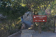
Access
The trail is accessed by the mule corral, as seen here:Description
| Distance (mi) | Elv (ft) | Location | Trail Junction |
|---|---|---|---|
| 0 | 6792 | Trailhead, South Rim | Rim Trail Rim Trail The Rim Trail is a hiking trail located on the North/South Rim of the Grand Canyon National Park, located in the U.S. state of Arizona.-External links:*... |
| 1.5 | 5729 | Mile-and-a-half Resthouse | |
| 3 | 4748 | Three Mile Resthouse | |
| 4.9 | 3255 | Indian Garden | Tonto Trail Tonto Trail The Tonto Trail is a hiking trail on the South Rim of the Grand Canyon in Grand Canyon National Park, located in the U.S. state of Arizona.-Access:... |
| Bright Angel Campground (via the River Trail) - 9.3 miles | 2580 | River Resthouse, Colorado River Colorado River The Colorado River , is a river in the Southwestern United States and northwestern Mexico, approximately long, draining a part of the arid regions on the western slope of the Rocky Mountains. The watershed of the Colorado River covers in parts of seven U.S. states and two Mexican states... |
River Trail River Trail (Arizona) The River Trail is a hiking trail in Grand Canyon National Park, located in the U.S. state of Arizona. This trail connects the end of the Bright Angel Trail with Phantom Ranch and the South Kaibab Trail.-Description:... |
The trail originates on the south rim of Grand Canyon
Grand Canyon
The Grand Canyon is a steep-sided canyon carved by the Colorado River in the United States in the state of Arizona. It is largely contained within the Grand Canyon National Park, the 15th national park in the United States...
and descends 4380 feet in elevation to the Colorado River
Colorado River
The Colorado River , is a river in the Southwestern United States and northwestern Mexico, approximately long, draining a part of the arid regions on the western slope of the Rocky Mountains. The watershed of the Colorado River covers in parts of seven U.S. states and two Mexican states...
. It has an average grade of 10% along its entire length. At trail's end, the River Trail
River Trail (Arizona)
The River Trail is a hiking trail in Grand Canyon National Park, located in the U.S. state of Arizona. This trail connects the end of the Bright Angel Trail with Phantom Ranch and the South Kaibab Trail.-Description:...
continues another 2 miles to the Bright Angel Campground and Phantom Ranch
Phantom Ranch
Phantom Ranch is a resort village within Grand Canyon National Park in Arizona. It is located on the north side of the Colorado River near its confluence with Bright Angel Creek and Phantom Creek.-History:...
. These two trails combined are the most common method used to access Phantom Ranch
Phantom Ranch
Phantom Ranch is a resort village within Grand Canyon National Park in Arizona. It is located on the north side of the Colorado River near its confluence with Bright Angel Creek and Phantom Creek.-History:...
by hikers and mules.
There are two trails that cross or join this trail. The first being the Tonto Trail
Tonto Trail
The Tonto Trail is a hiking trail on the South Rim of the Grand Canyon in Grand Canyon National Park, located in the U.S. state of Arizona.-Access:...
at Indian Gardens which leads towards the Monument Use Area to the west (the east leads to the South Kaibab Trail
South Kaibab Trail
The South Kaibab Trail is a hiking trail in Grand Canyon National Park, located in the U.S. state of Arizona. Unlike the Bright Angel Trail which also begins at the south rim of Grand Canyon and leads to the Colorado River, the South Kaibab Trail follows a ridge out to Skeleton Point allowing for...
4.7 miles (7.6 km) from the junction), and the River Trail
River Trail (Arizona)
The River Trail is a hiking trail in Grand Canyon National Park, located in the U.S. state of Arizona. This trail connects the end of the Bright Angel Trail with Phantom Ranch and the South Kaibab Trail.-Description:...
which officially begins when the Bright Angel Trail reaches the Colorado River
Colorado River
The Colorado River , is a river in the Southwestern United States and northwestern Mexico, approximately long, draining a part of the arid regions on the western slope of the Rocky Mountains. The watershed of the Colorado River covers in parts of seven U.S. states and two Mexican states...
at the River Resthouse, although some consider that the Bright Angel Trail officially ends after crossing the Colorado River at the Silver Bridge.
Condition
Grand Canyon National ParkGrand Canyon National Park
Grand Canyon National Park is the United States' 15th oldest national park and is located in Arizona. Within the park lies the Grand Canyon, a gorge of the Colorado River, considered to be one of the Wonders of the World. The park covers of unincorporated area in Coconino and Mohave counties.Most...
categorizes the Bright Angel Trail as a corridor trail. With this designation it receives regular maintenance and patrols by park rangers.
Water availability
Water is available from the trans-canyon pipeline at the Mile-and-a-half Resthouse, the Three Mile Resthouse, and Indian Garden. During cooler months (usually October-April) the two resthouses are shut off from the water supply to prevent the pipeline from freezing.Below Indian Gardens, both Garden Creek and Pipe Creek flow year-round (perennial). Water is also available at the River Resthouse from the Colorado River
Colorado River
The Colorado River , is a river in the Southwestern United States and northwestern Mexico, approximately long, draining a part of the arid regions on the western slope of the Rocky Mountains. The watershed of the Colorado River covers in parts of seven U.S. states and two Mexican states...
. All water from natural sources must be filtered, treated, or boiled prior to consuming.
Camping
Hikers can camp at Indian Garden Campground or at the Bright Angel Campground. In both these places, they can stay overnight with a permit issued by the Grand Canyon National Park Backcountry Information Center. Use of the campground overnight is regulated by the National Park Service, and they call for a maximum number of groups (7 to 11 people) and parties (1 to 6 people), as well as a maximum total number of persons.Use permits are available on a first-come, first-serve basis from the park's Backcountry Information Center. Requests are taken beginning on the 1st day of the month, up to four months before the requested first night of camping.
Hazards
Dehydration
In physiology and medicine, dehydration is defined as the excessive loss of body fluid. It is literally the removal of water from an object; however, in physiological terms, it entails a deficiency of fluid within an organism...
, sudden rainstorms, flash flood
Flash flood
A flash flood is a rapid flooding of geomorphic low-lying areas—washes, rivers, dry lakes and basins. It may be caused by heavy rain associated with a storm, hurricane, or tropical storm or meltwater from ice or snow flowing over ice sheets or snowfields...
ing, loose footing, bootpacked ice, rockfall
Landslide
A landslide or landslip is a geological phenomenon which includes a wide range of ground movement, such as rockfalls, deep failure of slopes and shallow debris flows, which can occur in offshore, coastal and onshore environments...
, encounters with wildlife
Wildlife
Wildlife includes all non-domesticated plants, animals and other organisms. Domesticating wild plant and animal species for human benefit has occurred many times all over the planet, and has a major impact on the environment, both positive and negative....
, and extreme heat. At the Colorado River
Colorado River
The Colorado River , is a river in the Southwestern United States and northwestern Mexico, approximately long, draining a part of the arid regions on the western slope of the Rocky Mountains. The watershed of the Colorado River covers in parts of seven U.S. states and two Mexican states...
, additional hazards include hypothermia
Hypothermia
Hypothermia is a condition in which core temperature drops below the required temperature for normal metabolism and body functions which is defined as . Body temperature is usually maintained near a constant level of through biologic homeostasis or thermoregulation...
(due to the river's consistently cold temperatures), trauma
Physical trauma
Trauma refers to "a body wound or shock produced by sudden physical injury, as from violence or accident." It can also be described as "a physical wound or injury, such as a fracture or blow." Major trauma can result in secondary complications such as circulatory shock, respiratory failure and death...
(due to collisions with boulders in rapids), and drowning
Drowning
Drowning is death from asphyxia due to suffocation caused by water entering the lungs and preventing the absorption of oxygen leading to cerebral hypoxia....
.
Also, the trail is used by the mules to ride to the bottom of the canyon. These mule
Mule
A mule is the offspring of a male donkey and a female horse. Horses and donkeys are different species, with different numbers of chromosomes. Of the two F1 hybrids between these two species, a mule is easier to obtain than a hinny...
s are highly trained
however the trail is not wide enough in some spots for a person and a mule; however, in many places there are areas for hikers and other travelers to seek temporary refuge from the mules. The trail also has many switchbacks, and a bad fall can result in serious injuries. Also, according to the mule tour guides for Xanterra, squirrel
Squirrel
Squirrels belong to a large family of small or medium-sized rodents called the Sciuridae. The family includes tree squirrels, ground squirrels, chipmunks, marmots , flying squirrels, and prairie dogs. Squirrels are indigenous to the Americas, Eurasia, and Africa and have been introduced to Australia...
bites at Plateau Point are the leading cause of infirmary visits by hikers and mule riders. Feeding the squirrels is strictly prohibited and highly discouraged.
History
The trail was originally built by the Havasupai (Havasu 'Baaja) Native AmericanNative Americans in the United States
Native Americans in the United States are the indigenous peoples in North America within the boundaries of the present-day continental United States, parts of Alaska, and the island state of Hawaii. They are composed of numerous, distinct tribes, states, and ethnic groups, many of which survive as...
tribe for access to the perennial water source of present day Garden Creek. The Havasu settled seasonally in this area, now known as Indian Garden.
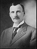
Ralph Cameron
Ralph H. CameronRalph H. Cameron
Ralph Henry Cameron was an American Republican politician, and a delegate and Senator from the state of Arizona. He died while on a business trip to Washington, D.C...
, who would later become a United States Senator (R
Republican Party (United States)
The Republican Party is one of the two major contemporary political parties in the United States, along with the Democratic Party. Founded by anti-slavery expansion activists in 1854, it is often called the GOP . The party's platform generally reflects American conservatism in the U.S...
-AZ 1921-1927), settled on the canyon rim in 1890 and began improving the old Havasupai trail. It was at this time that the trail was extended all the way to the Colorado River
Colorado River
The Colorado River , is a river in the Southwestern United States and northwestern Mexico, approximately long, draining a part of the arid regions on the western slope of the Rocky Mountains. The watershed of the Colorado River covers in parts of seven U.S. states and two Mexican states...
. Once official control of the trail fell to Cameron, he named it the Bright Angel Trail, commonly referred to in its early years as Cameron's Trail, and began charging a $1 toll to access it, plus additional fees for drinking water and the use of outhouses at Indian Gardens.
Kolb brothers
Ellsworth Kolb arrived at Grand Canyon to work at the Bright Angel Hotel in 1901. He was employed as a bellboy. The next year, Ellsworth invited his brother Emery to come to the canyon as the possibility of mine work opened up. However, John Hance'sJohn Hance
John Hance is thought to be the first non-Native American resident of the Grand Canyon. He opened the first tourist trail in the Canyon in the late nineteenth century. He started giving tours of the canyon after his attempts at mining asbestos failed, largely due to the expense of removing the...
asbestos mine closed before he arrived, leaving Emery unemployed.
Shortly after this, Emery discovered a photography
Photography
Photography is the art, science and practice of creating durable images by recording light or other electromagnetic radiation, either electronically by means of an image sensor or chemically by means of a light-sensitive material such as photographic film...
business for sale in Williams, Arizona
Williams, Arizona
Williams is a city in Coconino County, Arizona, United States west of Flagstaff. Its population was 2,842 at the 2000 census; according to 2006 Census Bureau estimates, the population of the city is 3,094. It lies on the route of Historic Route 66, Interstate 40, and the Southwest Chief Amtrak...
. He purchased the business for $
United States dollar
The United States dollar , also referred to as the American dollar, is the official currency of the United States of America. It is divided into 100 smaller units called cents or pennies....
425 ($9,690.24 in 2007
Inflation
In economics, inflation is a rise in the general level of prices of goods and services in an economy over a period of time.When the general price level rises, each unit of currency buys fewer goods and services. Consequently, inflation also reflects an erosion in the purchasing power of money – a...
) and moved the operation back to Grand Canyon. He and Ellsworth began taking photographs of visitors who took the mule rides down Cameron's trail, charging a fee for the pictures. The Cameron family leased a small piece of land nearby to Emery, where the two brothers set up a photography studio in a tent to develop and sell their photos.
The business was extremely profitable and after a few years the Kolb brothers built their permanent studio building on the rim of the canyon. Rock was blasted away to provide the foundation for the building, which is perched slightly below rim level.
Ellsworth left the venture in 1924, but Emery continued operating the studio until his death in 1976. The present-day Kolb Studio
Kolb Studio
Kolb Studio clings to the edge of Grand Canyon in Grand Canyon National Park. It was the home and photographic studio of pioneers Emery and Ellsworth Kolb. Begun in 1904, the building has evolved through two major additions and countless minor changes during its century of existence at Grand Canyon...
is operated by the Grand Canyon Association as a gift shop
Gift shop
A gift shop is a store primarily selling souvenirs relating to a particular topic or theme. The items sold often include coffee mugs, stuffed animals, t-shirts, postcards, handmade collections and other souvenirs....
, art studio, and history center.
Competition with Cameron
To compete with Cameron, the Atchison, Topeka, and Santa Fe Railroad improved an existing horsethief trail in Hermit Canyon (the Hermit TrailHermit Trail
The Hermit Trail is a hiking trail in Grand Canyon National Park, located in the U.S. state of Arizona. This trail provides access to a historic area of Grand Canyon and offers a more challenging route to the Colorado River for more experienced canyon hikers....
) in 1910. Beginning in 1918, the newly created National Park Service
National Park Service
The National Park Service is the U.S. federal agency that manages all national parks, many national monuments, and other conservation and historical properties with various title designations...
began construction of the South Kaibab Trail
South Kaibab Trail
The South Kaibab Trail is a hiking trail in Grand Canyon National Park, located in the U.S. state of Arizona. Unlike the Bright Angel Trail which also begins at the south rim of Grand Canyon and leads to the Colorado River, the South Kaibab Trail follows a ridge out to Skeleton Point allowing for...
near Yaki Point as an additional bypass for Cameron's tolls.
National Park Service Control
After a long series of legal battles, Cameron ceded control of the trail to the National Park Service in 1928, who stopped charging the $1 toll.