
South Kaibab Trail
Encyclopedia
The South Kaibab Trail is a hiking
trail
in Grand Canyon National Park
, located in the U.S.
state of Arizona
. Unlike the Bright Angel Trail
which also begins at the south rim of Grand Canyon
and leads to the Colorado River
, the South Kaibab Trail follows a ridge out to Skeleton Point allowing for 360-degree views of the canyon.
The trailhead for the South Kaibab Trail is located off of the Yaki Point Road, which is closed to private vehicles. The free Grand Canyon National Park
shuttle bus is the only way to access the trailhead. The trailhead also marks the eastern terminus of the Rim Trail
. From the trailhead, the trail heads north. Hikers begin with a steep descent through the Grand Canyon
's upper rock layers: the Kaibab Limestone and Toroweap Formation. At about 1/2 mile one can observe an excellent example of a pustule dome. Here a small deposit of less dense more buoyant evaporite
has punctured through a layer of harder limestone
above. Through the first ¾ mile, the trail cuts through the eastern side of Pipe Creek Canyon until Ooh-ahh Point, where the canyon walls turn around Yaki Point and the view of the eastern canyon opens up. The point is named after a common reaction to the view.
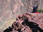
From Ooh-ahh Point the trail turns around a few switchbacks in a natural break in the Coconino Sandstone until Cedar Ridge, where the trail begins to level off slightly. Cedar Ridge has toilet facilities and offers a place for hikers and mule trains to rest. Below here, the trail continues north around the east site of O'Neill Butte, descending gradually through the Hermit Shale and Supai Group to Skeleton Point, three miles (5 km) from the trailhead. After Skeleton Point, the trail begins a sharp descent through a natural break in the Redwall Limestone. Despite the name, the natural color of the rock is light beige or gray. The trail cuts to the west of the point where hikers can get a view of Phantom Ranch
, then quickly back to the east side of the point. There are numerous switchbacks to descend the 1200 feet (365.8 m) through the Redwall Limestone, Muav Limestone, and Bright Angel Shale to the junction with the Tonto Trail
, 4½ miles from the trailhead.
 A sign marks the trail junction, which has toilet facilities. The Tonto Trail
heads west towards Indian Gardens, and east towards Horseshoe Mesa and Hance Rapids. About ¼ past the junction is a point called the Tipoff, where an emergency phone is located on the east side of the trail. After the Tipoff the trail makes its final steep descent to the bottom of the canyon, through the Tapeats Sandstone and Vishnu Schist. This section is the steepest of the South Kaibab Trail at an average of 22%. Six miles from the trailhead, there is a junction with the River Trail
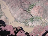
at its eastern terminus. One-half mile past the junction, there is a tunnel that leads across the Black Suspension Bridge crossing the Colorado River
. Mule trips from the south rim cross this bridge except when it is closed to traffic. The other crossing of the Colorado is about ¾ downstream on the Silver Suspension Bridge, accessible from the River Trail.
On the north site of the river the trail turns westward and descends slightly. There is a spur that leads to Boat Beach on the Colorado River, just downstream from the black bridge. About ½ mile past the bridge is the junction with the River Trail
and North Kaibab Trail
, marking the official end on the South Kaibab Trail seven miles (11 km) from the trailhead. There is a restroom and water spigot at the junction. The Bright Angel Campground is located just past here, and Phantom Ranch
is about ½ mile past the campground.
system, crossing the state of Arizona
from Mexico
to Utah
. The thru-trail continues north from here along the North Kaibab Trail
.
categorizes the South Kaibab Trail as a corridor trail. With this designation it receives regular maintenance and patrols by park rangers.
. Treated water is only available at the Bright Angel Campground and Phantom Ranch
. All water found from natural sources must be filtered, treated, or boiled prior to consuming.
Use permits are available on a first-come, first-serve basis from the park's Backcountry Information Center. Requests are taken beginning on the 1st day of the month, up to four month's before the requested first night of camping.
, sudden rainstorms, lightning, bootpacked ice, flash flooding, loose footing, rockfall, encounters with wildlife, and extreme heat. At the Colorado River
, additional hazards include hypothermia
(due to the river's consistently cold temperatures), trauma
(due to collisions with boulders in rapids), and drowning
.
Hiking
Hiking is an outdoor activity which consists of walking in natural environments, often in mountainous or other scenic terrain. People often hike on hiking trails. It is such a popular activity that there are numerous hiking organizations worldwide. The health benefits of different types of hiking...
trail
Trail
A trail is a path with a rough beaten or dirt/stone surface used for travel. Trails may be for use only by walkers and in some places are the main access route to remote settlements...
in Grand Canyon National Park
Grand Canyon National Park
Grand Canyon National Park is the United States' 15th oldest national park and is located in Arizona. Within the park lies the Grand Canyon, a gorge of the Colorado River, considered to be one of the Wonders of the World. The park covers of unincorporated area in Coconino and Mohave counties.Most...
, located in the U.S.
United States
The United States of America is a federal constitutional republic comprising fifty states and a federal district...
state of Arizona
Arizona
Arizona ; is a state located in the southwestern region of the United States. It is also part of the western United States and the mountain west. The capital and largest city is Phoenix...
. Unlike the Bright Angel Trail
Bright Angel Trail
The Bright Angel Trail is a hiking trail located in Grand Canyon National Park in the U.S. state of Arizona.-Access:The trail is accessed by the mule corral, as seen here:-Description:...
which also begins at the south rim of Grand Canyon
Grand Canyon
The Grand Canyon is a steep-sided canyon carved by the Colorado River in the United States in the state of Arizona. It is largely contained within the Grand Canyon National Park, the 15th national park in the United States...
and leads to the Colorado River
Colorado River
The Colorado River , is a river in the Southwestern United States and northwestern Mexico, approximately long, draining a part of the arid regions on the western slope of the Rocky Mountains. The watershed of the Colorado River covers in parts of seven U.S. states and two Mexican states...
, the South Kaibab Trail follows a ridge out to Skeleton Point allowing for 360-degree views of the canyon.
Description
| Distance (mi) | Elv (ft) | Location | Connecting trails | Toilet | Water | Phone |
|---|---|---|---|---|---|---|
| 0 | 7260 | Trailhead, near Yaki Point | Rim Trail Rim Trail The Rim Trail is a hiking trail located on the North/South Rim of the Grand Canyon National Park, located in the U.S. state of Arizona.-External links:*... Arizona Trail Arizona Trail The Arizona National Scenic Trail is a National Scenic Trail from Mexico to Utah that traverses the whole north-south length of Arizona. The trail begins at the Coronado National Memorial near the US-Mexico border and moves north through parts of the Huachuca, Santa Rita, and Rincon Mountains; it... |
Portable | Pay phone | |
| 1.5 | 6060 | Cedar Ridge | Composting | |||
| 3 | 5200 | Skeleton Point | ||||
| 4.4 | 4010 | Trail junction | Tonto Trail Tonto Trail The Tonto Trail is a hiking trail on the South Rim of the Grand Canyon in Grand Canyon National Park, located in the U.S. state of Arizona.-Access:... |
Composting | ||
| 4.6 | 3870 | The Tipoff | Emergency | |||
| 6.7 | 2600 | Black Suspension Bridge | River Trail River Trail (Arizona) The River Trail is a hiking trail in Grand Canyon National Park, located in the U.S. state of Arizona. This trail connects the end of the Bright Angel Trail with Phantom Ranch and the South Kaibab Trail.-Description:... |
|||
| 7.1 | 2480 | Bright Angel Campground | River Trail River Trail (Arizona) The River Trail is a hiking trail in Grand Canyon National Park, located in the U.S. state of Arizona. This trail connects the end of the Bright Angel Trail with Phantom Ranch and the South Kaibab Trail.-Description:... North Kaibab Trail North Kaibab Trail The North Kaibab Trail is a hiking trail in Grand Canyon National Park, located in the U.S. state of Arizona.-Access:Access to this part of the park by car is seasonal, open from mid-May to mid-October or depending on snowcover from the previous winter... |
Septic | Treated | Pay phones (at Phantom Ranch Phantom Ranch Phantom Ranch is a resort village within Grand Canyon National Park in Arizona. It is located on the north side of the Colorado River near its confluence with Bright Angel Creek and Phantom Creek.-History:... and River Ranger Station) |
The trailhead for the South Kaibab Trail is located off of the Yaki Point Road, which is closed to private vehicles. The free Grand Canyon National Park
Grand Canyon National Park
Grand Canyon National Park is the United States' 15th oldest national park and is located in Arizona. Within the park lies the Grand Canyon, a gorge of the Colorado River, considered to be one of the Wonders of the World. The park covers of unincorporated area in Coconino and Mohave counties.Most...
shuttle bus is the only way to access the trailhead. The trailhead also marks the eastern terminus of the Rim Trail
Rim Trail
The Rim Trail is a hiking trail located on the North/South Rim of the Grand Canyon National Park, located in the U.S. state of Arizona.-External links:*...
. From the trailhead, the trail heads north. Hikers begin with a steep descent through the Grand Canyon
Grand Canyon
The Grand Canyon is a steep-sided canyon carved by the Colorado River in the United States in the state of Arizona. It is largely contained within the Grand Canyon National Park, the 15th national park in the United States...
's upper rock layers: the Kaibab Limestone and Toroweap Formation. At about 1/2 mile one can observe an excellent example of a pustule dome. Here a small deposit of less dense more buoyant evaporite
Evaporite
Evaporite is a name for a water-soluble mineral sediment that result from concentration and crystallization by evaporation from an aqueous solution. There are two types of evaporate deposits, marine which can also be described as ocean deposits, and non-marine which are found in standing bodies of...
has punctured through a layer of harder limestone
Limestone
Limestone is a sedimentary rock composed largely of the minerals calcite and aragonite, which are different crystal forms of calcium carbonate . Many limestones are composed from skeletal fragments of marine organisms such as coral or foraminifera....
above. Through the first ¾ mile, the trail cuts through the eastern side of Pipe Creek Canyon until Ooh-ahh Point, where the canyon walls turn around Yaki Point and the view of the eastern canyon opens up. The point is named after a common reaction to the view.
From Ooh-ahh Point the trail turns around a few switchbacks in a natural break in the Coconino Sandstone until Cedar Ridge, where the trail begins to level off slightly. Cedar Ridge has toilet facilities and offers a place for hikers and mule trains to rest. Below here, the trail continues north around the east site of O'Neill Butte, descending gradually through the Hermit Shale and Supai Group to Skeleton Point, three miles (5 km) from the trailhead. After Skeleton Point, the trail begins a sharp descent through a natural break in the Redwall Limestone. Despite the name, the natural color of the rock is light beige or gray. The trail cuts to the west of the point where hikers can get a view of Phantom Ranch
Phantom Ranch
Phantom Ranch is a resort village within Grand Canyon National Park in Arizona. It is located on the north side of the Colorado River near its confluence with Bright Angel Creek and Phantom Creek.-History:...
, then quickly back to the east side of the point. There are numerous switchbacks to descend the 1200 feet (365.8 m) through the Redwall Limestone, Muav Limestone, and Bright Angel Shale to the junction with the Tonto Trail
Tonto Trail
The Tonto Trail is a hiking trail on the South Rim of the Grand Canyon in Grand Canyon National Park, located in the U.S. state of Arizona.-Access:...
, 4½ miles from the trailhead.
Tonto Trail
The Tonto Trail is a hiking trail on the South Rim of the Grand Canyon in Grand Canyon National Park, located in the U.S. state of Arizona.-Access:...
heads west towards Indian Gardens, and east towards Horseshoe Mesa and Hance Rapids. About ¼ past the junction is a point called the Tipoff, where an emergency phone is located on the east side of the trail. After the Tipoff the trail makes its final steep descent to the bottom of the canyon, through the Tapeats Sandstone and Vishnu Schist. This section is the steepest of the South Kaibab Trail at an average of 22%. Six miles from the trailhead, there is a junction with the River Trail
River Trail (Arizona)
The River Trail is a hiking trail in Grand Canyon National Park, located in the U.S. state of Arizona. This trail connects the end of the Bright Angel Trail with Phantom Ranch and the South Kaibab Trail.-Description:...
at its eastern terminus. One-half mile past the junction, there is a tunnel that leads across the Black Suspension Bridge crossing the Colorado River
Colorado River
The Colorado River , is a river in the Southwestern United States and northwestern Mexico, approximately long, draining a part of the arid regions on the western slope of the Rocky Mountains. The watershed of the Colorado River covers in parts of seven U.S. states and two Mexican states...
. Mule trips from the south rim cross this bridge except when it is closed to traffic. The other crossing of the Colorado is about ¾ downstream on the Silver Suspension Bridge, accessible from the River Trail.
On the north site of the river the trail turns westward and descends slightly. There is a spur that leads to Boat Beach on the Colorado River, just downstream from the black bridge. About ½ mile past the bridge is the junction with the River Trail
River Trail (Arizona)
The River Trail is a hiking trail in Grand Canyon National Park, located in the U.S. state of Arizona. This trail connects the end of the Bright Angel Trail with Phantom Ranch and the South Kaibab Trail.-Description:...
and North Kaibab Trail
North Kaibab Trail
The North Kaibab Trail is a hiking trail in Grand Canyon National Park, located in the U.S. state of Arizona.-Access:Access to this part of the park by car is seasonal, open from mid-May to mid-October or depending on snowcover from the previous winter...
, marking the official end on the South Kaibab Trail seven miles (11 km) from the trailhead. There is a restroom and water spigot at the junction. The Bright Angel Campground is located just past here, and Phantom Ranch
Phantom Ranch
Phantom Ranch is a resort village within Grand Canyon National Park in Arizona. It is located on the north side of the Colorado River near its confluence with Bright Angel Creek and Phantom Creek.-History:...
is about ½ mile past the campground.
Part of Arizona Trail
The South Kaibab Trail is also part of the Arizona TrailArizona Trail
The Arizona National Scenic Trail is a National Scenic Trail from Mexico to Utah that traverses the whole north-south length of Arizona. The trail begins at the Coronado National Memorial near the US-Mexico border and moves north through parts of the Huachuca, Santa Rita, and Rincon Mountains; it...
system, crossing the state of Arizona
Arizona
Arizona ; is a state located in the southwestern region of the United States. It is also part of the western United States and the mountain west. The capital and largest city is Phoenix...
from Mexico
Mexico
The United Mexican States , commonly known as Mexico , is a federal constitutional republic in North America. It is bordered on the north by the United States; on the south and west by the Pacific Ocean; on the southeast by Guatemala, Belize, and the Caribbean Sea; and on the east by the Gulf of...
to Utah
Utah
Utah is a state in the Western United States. It was the 45th state to join the Union, on January 4, 1896. Approximately 80% of Utah's 2,763,885 people live along the Wasatch Front, centering on Salt Lake City. This leaves vast expanses of the state nearly uninhabited, making the population the...
. The thru-trail continues north from here along the North Kaibab Trail
North Kaibab Trail
The North Kaibab Trail is a hiking trail in Grand Canyon National Park, located in the U.S. state of Arizona.-Access:Access to this part of the park by car is seasonal, open from mid-May to mid-October or depending on snowcover from the previous winter...
.
Condition
Grand Canyon National ParkGrand Canyon National Park
Grand Canyon National Park is the United States' 15th oldest national park and is located in Arizona. Within the park lies the Grand Canyon, a gorge of the Colorado River, considered to be one of the Wonders of the World. The park covers of unincorporated area in Coconino and Mohave counties.Most...
categorizes the South Kaibab Trail as a corridor trail. With this designation it receives regular maintenance and patrols by park rangers.
Water availability
Water is not available at any point along the South Kaibab Trail, except on the north side of the Colorado RiverColorado River
The Colorado River , is a river in the Southwestern United States and northwestern Mexico, approximately long, draining a part of the arid regions on the western slope of the Rocky Mountains. The watershed of the Colorado River covers in parts of seven U.S. states and two Mexican states...
. Treated water is only available at the Bright Angel Campground and Phantom Ranch
Phantom Ranch
Phantom Ranch is a resort village within Grand Canyon National Park in Arizona. It is located on the north side of the Colorado River near its confluence with Bright Angel Creek and Phantom Creek.-History:...
. All water found from natural sources must be filtered, treated, or boiled prior to consuming.
Camping
Hikers may only camp at the Bright Angel Campground, where they can stay overnight with a permit issued by the Grand Canyon National Park Backcountry Information Center. Use of the campground overnight is regulated by the National Park Service, and they call for a maximum number of groups (7 to 11 people) and parties (1 to 6 people), as well as a maximum total number of persons. Wood and charcoal fires are not permitted; camp stoves only.| Area | Name | Type | Group(s) | Parties | Max People | |
|---|---|---|---|---|---|---|
| CBG | Bright Angel | Campground | 2 | and | 31 | 90 |
Use permits are available on a first-come, first-serve basis from the park's Backcountry Information Center. Requests are taken beginning on the 1st day of the month, up to four month's before the requested first night of camping.
Hazards
Hazards hikers can encounter along the South Kaibab Trail include dehydrationDehydration
In physiology and medicine, dehydration is defined as the excessive loss of body fluid. It is literally the removal of water from an object; however, in physiological terms, it entails a deficiency of fluid within an organism...
, sudden rainstorms, lightning, bootpacked ice, flash flooding, loose footing, rockfall, encounters with wildlife, and extreme heat. At the Colorado River
Colorado River
The Colorado River , is a river in the Southwestern United States and northwestern Mexico, approximately long, draining a part of the arid regions on the western slope of the Rocky Mountains. The watershed of the Colorado River covers in parts of seven U.S. states and two Mexican states...
, additional hazards include hypothermia
Hypothermia
Hypothermia is a condition in which core temperature drops below the required temperature for normal metabolism and body functions which is defined as . Body temperature is usually maintained near a constant level of through biologic homeostasis or thermoregulation...
(due to the river's consistently cold temperatures), trauma
Physical trauma
Trauma refers to "a body wound or shock produced by sudden physical injury, as from violence or accident." It can also be described as "a physical wound or injury, such as a fracture or blow." Major trauma can result in secondary complications such as circulatory shock, respiratory failure and death...
(due to collisions with boulders in rapids), and drowning
Drowning
Drowning is death from asphyxia due to suffocation caused by water entering the lungs and preventing the absorption of oxygen leading to cerebral hypoxia....
.