
Grandview Trail
Encyclopedia
The Grandview Trail is a hiking
trail
located on the South Rim of the Grand Canyon National Park
, located in the U.S. state
of Arizona
.
. From the trail head, it makes a quick descent through the Kaibab Limestone and Toroweap Formation, making a couple of early switchbacks. Portions of this section of trail were reconstructed in the summer of 2005 after a couple of storms washed them out.
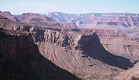
The trail generally follows the western side of the ridge that extends northeast of Grandview Point which marks a natural break in the Coconino Sandstone. The trail turns to the north and makes a final descent through the Hermit Shale and Supai Group until it reaches Horseshoe Mesa, 3 miles (5 km) from the trail head, after a descent of 2500 feet (762 m).
Camping is allowed on the mesa in designated areas on its eastern side and by permit only. Permits are issued by the Backcountry Information Center. Signage on trail indicates the locations of the campsites. Composting toilets have been installed, but no water is available on the mesa.
The trail splits on Horseshoe Mesa near the Last Chance Mine. A spur trail leads east down a break in the Redwall Limestone on the eastern side of the mesa close to the rim. The spur trail is steep, leading past Miners Spring which is the nearest water source for camping on Horseshoe Mesa. The end of this spur is about 4.5 miles (7.2 km) from the Grandview trail head at a junction with the Tonto Trail
and leads to the head of Hance Canyon, a perennial water source and alternate camping area.
To the west of Last Chance Mine, a western spur from the Grandview Trail cuts through a break in the Redwall Limestone and descends the western side of the mesa following Cottonwood Creek. Water taken from this source must be filtered, treated, or boiled before consuming.
The Grandview Trail follows the west side of a small butte that caps the mesa. It leads to the northern end of the mesa, and then descends between the two arms of the mesa to a junction with the Tonto Trail
. From this point, the east branch doubles back toward Hance Canyon, and the west branch leads to Cottonwood Creek.
Hiking
Hiking is an outdoor activity which consists of walking in natural environments, often in mountainous or other scenic terrain. People often hike on hiking trails. It is such a popular activity that there are numerous hiking organizations worldwide. The health benefits of different types of hiking...
trail
Trail
A trail is a path with a rough beaten or dirt/stone surface used for travel. Trails may be for use only by walkers and in some places are the main access route to remote settlements...
located on the South Rim of the Grand Canyon National Park
Grand Canyon National Park
Grand Canyon National Park is the United States' 15th oldest national park and is located in Arizona. Within the park lies the Grand Canyon, a gorge of the Colorado River, considered to be one of the Wonders of the World. The park covers of unincorporated area in Coconino and Mohave counties.Most...
, located in the U.S. state
U.S. state
A U.S. state is any one of the 50 federated states of the United States of America that share sovereignty with the federal government. Because of this shared sovereignty, an American is a citizen both of the federal entity and of his or her state of domicile. Four states use the official title of...
of Arizona
Arizona
Arizona ; is a state located in the southwestern region of the United States. It is also part of the western United States and the mountain west. The capital and largest city is Phoenix...
.
Description
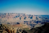
The trail begins at the north end of the Grandview Point parking area, off of Arizona state route 64, 12 miles (19.3 km) east of Grand Canyon Village, ArizonaGrand Canyon Village, Arizona
Grand Canyon Village is a census-designated place located on the South Rim of the Grand Canyon, in Coconino County, Arizona. Its population was 1,460 at the 2000 Census. Located in Grand Canyon National Park, it is wholly focused on accommodating tourists visiting the canyon...
. From the trail head, it makes a quick descent through the Kaibab Limestone and Toroweap Formation, making a couple of early switchbacks. Portions of this section of trail were reconstructed in the summer of 2005 after a couple of storms washed them out.
The trail generally follows the western side of the ridge that extends northeast of Grandview Point which marks a natural break in the Coconino Sandstone. The trail turns to the north and makes a final descent through the Hermit Shale and Supai Group until it reaches Horseshoe Mesa, 3 miles (5 km) from the trail head, after a descent of 2500 feet (762 m).
Camping is allowed on the mesa in designated areas on its eastern side and by permit only. Permits are issued by the Backcountry Information Center. Signage on trail indicates the locations of the campsites. Composting toilets have been installed, but no water is available on the mesa.
The trail splits on Horseshoe Mesa near the Last Chance Mine. A spur trail leads east down a break in the Redwall Limestone on the eastern side of the mesa close to the rim. The spur trail is steep, leading past Miners Spring which is the nearest water source for camping on Horseshoe Mesa. The end of this spur is about 4.5 miles (7.2 km) from the Grandview trail head at a junction with the Tonto Trail
Tonto Trail
The Tonto Trail is a hiking trail on the South Rim of the Grand Canyon in Grand Canyon National Park, located in the U.S. state of Arizona.-Access:...
and leads to the head of Hance Canyon, a perennial water source and alternate camping area.
To the west of Last Chance Mine, a western spur from the Grandview Trail cuts through a break in the Redwall Limestone and descends the western side of the mesa following Cottonwood Creek. Water taken from this source must be filtered, treated, or boiled before consuming.
The Grandview Trail follows the west side of a small butte that caps the mesa. It leads to the northern end of the mesa, and then descends between the two arms of the mesa to a junction with the Tonto Trail
Tonto Trail
The Tonto Trail is a hiking trail on the South Rim of the Grand Canyon in Grand Canyon National Park, located in the U.S. state of Arizona.-Access:...
. From this point, the east branch doubles back toward Hance Canyon, and the west branch leads to Cottonwood Creek.