
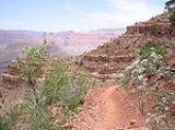
Hermit Trail
Encyclopedia
The Hermit Trail is a hiking
trail
in Grand Canyon National Park
, located in the U.S. state
of Arizona
. This trail provides access to a historic area of Grand Canyon
and offers a more challenging route to the Colorado River
for more experienced canyon hikers.
on the South Rim of the Grand Canyon
. The trailhead is accessible by shuttle bus from Grand Canyon Village, Arizona
on the Hermit Road. The road is closed to private vehicles between April and October annually, and is open to all traffic other months. Two exceptions are for vehicles with government issued handicap placards and backpackers with valid permits for overnight camping in the Hermit use area. Those users can obtain the gate code by visiting the Backcountry Information Center in the park.
Numerous rockslides cut through the trail and require rock scrambling and route finding to pass. The most recent major rockslide occurred in the evening of 1 March 1983, when a large section of rock in the Supai Group broke away from a cliff face and scattered down Hermit Canyon, cutting the Hermit Trail in two places. A rockslide that took place in the early 1930s cuts through the trail in a third place. These breaks in the trail require scrambling to get over, but are well marked with cairns.
Water is available year-round at Hermit Creek and the Colorado River
. The trail between the Hermit Creek camping area and the Colorado River
parallels Hermit Creek and provides additional water accessibility. Also, water flows periodically from Santa Maria Spring, located 2 trail miles in from the trailhead, but should not be counted on.
Hermit Creek above the Hermit Creek campsite is dry except in time of flood or flash flood.
The park's Backcountry Information Center has current water conditions for all water sources along the Hermit Trail.
Backcountry Information Center. Use of these areas overnight are regulated by the National Park Service
, and they call for a maximum number of groups (7 to 11 people) and parties (1 to 6 people), as well as a maximum total number of persons.
There are two designated campsites in the Hermit Use Area. The three letter code indicates the park's use area designation:
Use permits are available on a first-come, first-serve basis from the park's Backcountry Information Center. Requests are taken beginning on the 1st day of the month, up to four month's before the requested first night of camping.
, sudden rainstorms, flash flooding, loose footing, rockfall, encounters with wildlife, and extreme heat. At the Colorado River
, additional hazards include hypothermia
(due to the river's consistently cold temperatures), trauma
(due to collisions with boulders in rapids), and drowning
.
which charged a toll at the time. The railroad operated Hermit Camp about 7 trail miles below rim until 1930s when the National Park Service took over control of the Bright Angel Trail
and officially rescinded its tolls.
, sandstone
, chalk
, chert
, feldspar
, obsidian
, and other sedimentary rock
s, as well as some igneous ones
. Rocks by the Colorado River
are often heavily weathered
. Some of the limestone is fossil
iferous, mostly representing bivalves.
Hiking
Hiking is an outdoor activity which consists of walking in natural environments, often in mountainous or other scenic terrain. People often hike on hiking trails. It is such a popular activity that there are numerous hiking organizations worldwide. The health benefits of different types of hiking...
trail
Trail
A trail is a path with a rough beaten or dirt/stone surface used for travel. Trails may be for use only by walkers and in some places are the main access route to remote settlements...
in Grand Canyon National Park
Grand Canyon National Park
Grand Canyon National Park is the United States' 15th oldest national park and is located in Arizona. Within the park lies the Grand Canyon, a gorge of the Colorado River, considered to be one of the Wonders of the World. The park covers of unincorporated area in Coconino and Mohave counties.Most...
, located in the U.S. state
U.S. state
A U.S. state is any one of the 50 federated states of the United States of America that share sovereignty with the federal government. Because of this shared sovereignty, an American is a citizen both of the federal entity and of his or her state of domicile. Four states use the official title of...
of Arizona
Arizona
Arizona ; is a state located in the southwestern region of the United States. It is also part of the western United States and the mountain west. The capital and largest city is Phoenix...
. This trail provides access to a historic area of Grand Canyon
Grand Canyon
The Grand Canyon is a steep-sided canyon carved by the Colorado River in the United States in the state of Arizona. It is largely contained within the Grand Canyon National Park, the 15th national park in the United States...
and offers a more challenging route to the Colorado River
Colorado River
The Colorado River , is a river in the Southwestern United States and northwestern Mexico, approximately long, draining a part of the arid regions on the western slope of the Rocky Mountains. The watershed of the Colorado River covers in parts of seven U.S. states and two Mexican states...
for more experienced canyon hikers.
Access
The trailhead is located 0.25 mile (0.402335 km) southwest of Hermit's RestHermit's Rest
Hermit's Rest is a structure built in 1914 at the western end of Hermit Road at the south rim of the Grand Canyon in Arizona, United States. The Hermit Trail, a hiking trail that extends to the Colorado River, begins about ¼ mile beyond the shuttle bus stop at Hermit's Rest. Hermit's Rest also...
on the South Rim of the Grand Canyon
Grand Canyon
The Grand Canyon is a steep-sided canyon carved by the Colorado River in the United States in the state of Arizona. It is largely contained within the Grand Canyon National Park, the 15th national park in the United States...
. The trailhead is accessible by shuttle bus from Grand Canyon Village, Arizona
Grand Canyon Village, Arizona
Grand Canyon Village is a census-designated place located on the South Rim of the Grand Canyon, in Coconino County, Arizona. Its population was 1,460 at the 2000 Census. Located in Grand Canyon National Park, it is wholly focused on accommodating tourists visiting the canyon...
on the Hermit Road. The road is closed to private vehicles between April and October annually, and is open to all traffic other months. Two exceptions are for vehicles with government issued handicap placards and backpackers with valid permits for overnight camping in the Hermit use area. Those users can obtain the gate code by visiting the Backcountry Information Center in the park.
Description
| Distance (mi) | Elv (ft) | Location | Connecting trails | Toilet | Water |
|---|---|---|---|---|---|
| 0 | 6640 | Trailhead, Hermit's Rest Hermit's Rest Hermit's Rest is a structure built in 1914 at the western end of Hermit Road at the south rim of the Grand Canyon in Arizona, United States. The Hermit Trail, a hiking trail that extends to the Colorado River, begins about ¼ mile beyond the shuttle bus stop at Hermit's Rest. Hermit's Rest also... |
Rim Trail Rim Trail The Rim Trail is a hiking trail located on the North/South Rim of the Grand Canyon National Park, located in the U.S. state of Arizona.-External links:*... |
Portable | |
| 1.2 | 5400 | Trail Junction | Waldron Trail Waldron Trail The Waldron Trail is a hiking trail on the South Rim of the Grand Canyon National Park, located in the U.S. state of Arizona. It is an alternative to Hermit Trail.-External links:*... |
||
| 1.6 | 5240 | Trail Junction | Dripping Springs Trail Dripping Springs Trail The Dripping Springs Trail is a hiking trail on the South Rim of the Grand Canyon National Park, located in the U.S. state of Arizona.-Access:The trail begins along the Hermit Trail after a 1½ mile hike from Hermit's Rest.-Description:... |
||
| 2 | 4900 | Santa Maria Spring | Ephemeral | ||
| 4 | 4200 | Lookout Point | |||
| 6.2 | 3120 | Trail Junction | Tonto Trail Tonto Trail The Tonto Trail is a hiking trail on the South Rim of the Grand Canyon in Grand Canyon National Park, located in the U.S. state of Arizona.-Access:... East |
||
| 7.8 | 3040 | Hermit Creek Campsite | Tonto Trail Tonto Trail The Tonto Trail is a hiking trail on the South Rim of the Grand Canyon in Grand Canyon National Park, located in the U.S. state of Arizona.-Access:... West |
Composting | Hermit Creek, Perennial |
| 8.9 | 2400 | Hermit Rapids, Colorado River Colorado River The Colorado River , is a river in the Southwestern United States and northwestern Mexico, approximately long, draining a part of the arid regions on the western slope of the Rocky Mountains. The watershed of the Colorado River covers in parts of seven U.S. states and two Mexican states... |
Hermit Creek, Colorado River | ||
Condition
Grand Canyon National Park categorizes the Hermit Trail as a threshold trail and does not officially maintain it. The trail is rutted in many places, and the once exquisite construction of placed stones on the upper-half of the trail is now crumbling and rough.Numerous rockslides cut through the trail and require rock scrambling and route finding to pass. The most recent major rockslide occurred in the evening of 1 March 1983, when a large section of rock in the Supai Group broke away from a cliff face and scattered down Hermit Canyon, cutting the Hermit Trail in two places. A rockslide that took place in the early 1930s cuts through the trail in a third place. These breaks in the trail require scrambling to get over, but are well marked with cairns.
Water availability
All water sources along this trail must be treated, filtered, or boiled before drinking.Water is available year-round at Hermit Creek and the Colorado River
Colorado River
The Colorado River , is a river in the Southwestern United States and northwestern Mexico, approximately long, draining a part of the arid regions on the western slope of the Rocky Mountains. The watershed of the Colorado River covers in parts of seven U.S. states and two Mexican states...
. The trail between the Hermit Creek camping area and the Colorado River
Colorado River
The Colorado River , is a river in the Southwestern United States and northwestern Mexico, approximately long, draining a part of the arid regions on the western slope of the Rocky Mountains. The watershed of the Colorado River covers in parts of seven U.S. states and two Mexican states...
parallels Hermit Creek and provides additional water accessibility. Also, water flows periodically from Santa Maria Spring, located 2 trail miles in from the trailhead, but should not be counted on.
Hermit Creek above the Hermit Creek campsite is dry except in time of flood or flash flood.
The park's Backcountry Information Center has current water conditions for all water sources along the Hermit Trail.
Camping
Camping is allowed in designated sites along the Hermit Trail by permit only, issued by the Grand Canyon National ParkGrand Canyon National Park
Grand Canyon National Park is the United States' 15th oldest national park and is located in Arizona. Within the park lies the Grand Canyon, a gorge of the Colorado River, considered to be one of the Wonders of the World. The park covers of unincorporated area in Coconino and Mohave counties.Most...
Backcountry Information Center. Use of these areas overnight are regulated by the National Park Service
National Park Service
The National Park Service is the U.S. federal agency that manages all national parks, many national monuments, and other conservation and historical properties with various title designations...
, and they call for a maximum number of groups (7 to 11 people) and parties (1 to 6 people), as well as a maximum total number of persons.
There are two designated campsites in the Hermit Use Area. The three letter code indicates the park's use area designation:
- BM7 - Hermit Creek / Up to 23 persons for 1 group and 3 parties.
- BM8 - Hermit Rapids / Up to 17 persons for 1 group and 1 party.
Use permits are available on a first-come, first-serve basis from the park's Backcountry Information Center. Requests are taken beginning on the 1st day of the month, up to four month's before the requested first night of camping.
Hazards
Hazards hikers can encounter along the Hermit Trail include dehydrationDehydration
In physiology and medicine, dehydration is defined as the excessive loss of body fluid. It is literally the removal of water from an object; however, in physiological terms, it entails a deficiency of fluid within an organism...
, sudden rainstorms, flash flooding, loose footing, rockfall, encounters with wildlife, and extreme heat. At the Colorado River
Colorado River
The Colorado River , is a river in the Southwestern United States and northwestern Mexico, approximately long, draining a part of the arid regions on the western slope of the Rocky Mountains. The watershed of the Colorado River covers in parts of seven U.S. states and two Mexican states...
, additional hazards include hypothermia
Hypothermia
Hypothermia is a condition in which core temperature drops below the required temperature for normal metabolism and body functions which is defined as . Body temperature is usually maintained near a constant level of through biologic homeostasis or thermoregulation...
(due to the river's consistently cold temperatures), trauma
Physical trauma
Trauma refers to "a body wound or shock produced by sudden physical injury, as from violence or accident." It can also be described as "a physical wound or injury, such as a fracture or blow." Major trauma can result in secondary complications such as circulatory shock, respiratory failure and death...
(due to collisions with boulders in rapids), and drowning
Drowning
Drowning is death from asphyxia due to suffocation caused by water entering the lungs and preventing the absorption of oxygen leading to cerebral hypoxia....
.
History
This trail was built in the last decade of the 19th century by horsetheives, but was improved by different prospectors of that era, most notably Dan Hogan. The Atchison, Topeka and Santa Fe Railway improved the trail further around 1910 to compete with the Camerons' Bright Angel TrailBright Angel Trail
The Bright Angel Trail is a hiking trail located in Grand Canyon National Park in the U.S. state of Arizona.-Access:The trail is accessed by the mule corral, as seen here:-Description:...
which charged a toll at the time. The railroad operated Hermit Camp about 7 trail miles below rim until 1930s when the National Park Service took over control of the Bright Angel Trail
Bright Angel Trail
The Bright Angel Trail is a hiking trail located in Grand Canyon National Park in the U.S. state of Arizona.-Access:The trail is accessed by the mule corral, as seen here:-Description:...
and officially rescinded its tolls.
Geology
Major rocks along this trail include limestoneLimestone
Limestone is a sedimentary rock composed largely of the minerals calcite and aragonite, which are different crystal forms of calcium carbonate . Many limestones are composed from skeletal fragments of marine organisms such as coral or foraminifera....
, sandstone
Sandstone
Sandstone is a sedimentary rock composed mainly of sand-sized minerals or rock grains.Most sandstone is composed of quartz and/or feldspar because these are the most common minerals in the Earth's crust. Like sand, sandstone may be any colour, but the most common colours are tan, brown, yellow,...
, chalk
Chalk
Chalk is a soft, white, porous sedimentary rock, a form of limestone composed of the mineral calcite. Calcite is calcium carbonate or CaCO3. It forms under reasonably deep marine conditions from the gradual accumulation of minute calcite plates shed from micro-organisms called coccolithophores....
, chert
Chert
Chert is a fine-grained silica-rich microcrystalline, cryptocrystalline or microfibrous sedimentary rock that may contain small fossils. It varies greatly in color , but most often manifests as gray, brown, grayish brown and light green to rusty red; its color is an expression of trace elements...
, feldspar
Feldspar
Feldspars are a group of rock-forming tectosilicate minerals which make up as much as 60% of the Earth's crust....
, obsidian
Obsidian
Obsidian is a naturally occurring volcanic glass formed as an extrusive igneous rock.It is produced when felsic lava extruded from a volcano cools rapidly with minimum crystal growth...
, and other sedimentary rock
Sedimentary rock
Sedimentary rock are types of rock that are formed by the deposition of material at the Earth's surface and within bodies of water. Sedimentation is the collective name for processes that cause mineral and/or organic particles to settle and accumulate or minerals to precipitate from a solution....
s, as well as some igneous ones
Igneous rock
Igneous rock is one of the three main rock types, the others being sedimentary and metamorphic rock. Igneous rock is formed through the cooling and solidification of magma or lava...
. Rocks by the Colorado River
Colorado River
The Colorado River , is a river in the Southwestern United States and northwestern Mexico, approximately long, draining a part of the arid regions on the western slope of the Rocky Mountains. The watershed of the Colorado River covers in parts of seven U.S. states and two Mexican states...
are often heavily weathered
Weathering
Weathering is the breaking down of rocks, soils and minerals as well as artificial materials through contact with the Earth's atmosphere, biota and waters...
. Some of the limestone is fossil
Fossil
Fossils are the preserved remains or traces of animals , plants, and other organisms from the remote past...
iferous, mostly representing bivalves.