

Timeline of the 2006 Pacific hurricane season
Encyclopedia

2006 Pacific hurricane season
The 2006 Pacific hurricane season was the most active Pacific hurricane season since 2000 producing 19 tropical storms or hurricanes. Eighteen developed within the National Hurricane Center area of warning responsibility, which is east of 140ºW, and one storm formed between 140ºW and the...
was the most active since the 2000 season
2000 Pacific hurricane season
The 2000 Pacific hurricane season was an event in tropical cyclone meteorology. There were few notable storms this year. Tropical Storms Miriam, Norman, and Rosa all made landfall in Mexico with minimal impact. Hurricane Daniel briefly threatened the U.S. state of Hawaii while weakening...
, producing produced 21 tropical depressions; 19 of which became tropical storms
Tropical cyclone
A tropical cyclone is a storm system characterized by a large low-pressure center and numerous thunderstorms that produce strong winds and heavy rain. Tropical cyclones strengthen when water evaporated from the ocean is released as the saturated air rises, resulting in condensation of water vapor...
or hurricanes. The season officially started on May 15, 2006 in the eastern Pacific, designated as the area east of 140°W
Longitude
Longitude is a geographic coordinate that specifies the east-west position of a point on the Earth's surface. It is an angular measurement, usually expressed in degrees, minutes and seconds, and denoted by the Greek letter lambda ....
, and on June 1, 2006 in the central Pacific, which is between the International Date Line
International Date Line
The International Date Line is a generally north-south imaginary line on the surface of the Earth, passing through the middle of the Pacific Ocean, that designates the place where each calendar day begins...
and 140°W, and lasted until November 30, 2006. These dates typically limit the period of each year when most tropical cyclones form in the eastern Pacific basin
Pacific hurricane
A Pacific hurricane or tropical storm is a tropical cyclone that develops in the northeastern part of the Pacific Ocean. For organizational purposes, the northern Pacific Ocean is divided into three regions: the eastern, , central , and western...
. This timeline documents all the storm formations, strengthening, weakening, landfalls
Landfall (meteorology)
Landfall is the event of a tropical cyclone or a waterspout coming onto land after being over water. When a waterspout makes landfall it is reclassified as a tornado, which can then cause damage inland...
, extratropical transitions, as well as dissipation. The timeline also includes information which was not operationally released, meaning that information from post-storm reviews by the National Hurricane Center
National Hurricane Center
The National Hurricane Center , located at Florida International University in Miami, Florida, is the division of the National Weather Service responsible for tracking and predicting weather systems within the tropics between the Prime Meridian and the 140th meridian west poleward to the 30th...
, such as information on a storm that was not operationally warned on, have been included.
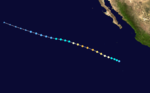
The first storm of the season, Tropical Storm Aletta, formed off the southwest coast of Mexico. After no storms formed in June, the season became active again in July when five named storms developed, including Hurricane Daniel
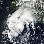
Hurricane Daniel (2006)
Hurricane Daniel was the second strongest hurricane of the 2006 Pacific hurricane season. The fourth named storm of the season, Daniel originated on July 16 from a tropical wave off the coast of Mexico. It tracked westward, intensifying steadily to reach peak winds of 150 mph on...
, which was the second strongest storm of the season. Six storms formed during August, including Hurricane Ioke
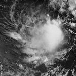
Hurricane Ioke
Hurricane Ioke was the strongest hurricane ever recorded in the Central Pacific...
and Hurricane John
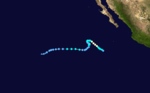
Hurricane John (2006)
Hurricane John was the eleventh named storm, seventh hurricane, and fifth major hurricane of the 2006 Pacific hurricane season. Hurricane John developed on August 28 from a tropical wave to the south of Mexico. Favorable conditions allowed the storm to intensify quickly, and it attained peak winds...
. September was a relatively inactive month, producing only two storms, of which one was Hurricane Lane. Three storms developed in October and two formed in November; this marked the first time on record when more than one tropical storm developed in the basin during the month of November.
May
.jpg)
- The Eastern Pacific hurricane season officially begins.
May 26
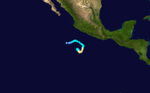
- 11:00 a.m. PDT (06:00 UTC May 27) – Tropical Depression One-E forms 190 miles (305 km) southwest of AcapulcoAcapulcoAcapulco is a city, municipality and major sea port in the state of Guerrero on the Pacific coast of Mexico, southwest from Mexico City. Acapulco is located on a deep, semi-circular bay and has been a port since the early colonial period of Mexico’s history...
, MexicoMexicoThe United Mexican States , commonly known as Mexico , is a federal constitutional republic in North America. It is bordered on the north by the United States; on the south and west by the Pacific Ocean; on the southeast by Guatemala, Belize, and the Caribbean Sea; and on the east by the Gulf of...
. - 11:00 p.m. PDTPacific Time ZoneThe Pacific Time Zone observes standard time by subtracting eight hours from Coordinated Universal Time . The clock time in this zone is based on the mean solar time of the 120th meridian west of the Greenwich Observatory. During daylight saving time, its time offset is UTC-7.In the United States...
(18:00 UTCCoordinated Universal TimeCoordinated Universal Time is the primary time standard by which the world regulates clocks and time. It is one of several closely related successors to Greenwich Mean Time. Computer servers, online services and other entities that rely on having a universally accepted time use UTC for that purpose...
) – Tropical Depression One-E strengthens into Tropical Storm AlettaTropical Storm Aletta (2006)Tropical Storm Aletta was the first tropical cyclone of the 2006 Pacific hurricane season. Aletta developed from an area of disturbed weather located south-southwest of the Mexican port of Acapulco, Guerrero...
.
May 29
- 8:00 p.m. PDT (03:00 UTC May 30) – Tropical Storm Aletta is downgraded to a tropical depression.
May 30
- 5:00 p.m. PDT (00:00 UTC May 31) – Tropical Depression Aletta becomes a remnant low.
June
June 1- The Central Pacific hurricane season officially begins.
June 3
- 11:00 a.m. PDT (19:00 UTC) – Tropical Depression Two-ETropical Depression Two-E (2006)Tropical Depression Two-E in 2006 was a short-lived tropical cyclone that brought heavy rainfall to southwestern Mexico. It was the only cyclone during the month in the eastern North Pacific Ocean, forming on June 3 from a tropical wave...
forms 145 miles (230 km) southwest of ZihuatanejoZihuatanejoZihuatanejo or Ixtapa-Zihuatanejo, is the fourth-largest city in the Mexican state of Guerrero. Politically the city belongs to the municipality of Zihuatanejo de Azueta in the western part of Guerrero, but both are commonly referred to as Zihuatanejo...
, MexicoMexicoThe United Mexican States , commonly known as Mexico , is a federal constitutional republic in North America. It is bordered on the north by the United States; on the south and west by the Pacific Ocean; on the southeast by Guatemala, Belize, and the Caribbean Sea; and on the east by the Gulf of...
.
June 4
- 11:00 p.m. PDT (06:00 UTC June 5) – Tropical Depression Two-E dissipates.
July
- 5:00 p.m. PDT (00:00 UTC July 11) – Tropical Depression Three-E forms 810 miles (1,295 km) south of Cabo San LucasCabo San LucasCabo San Lucas , commonly called Cabo, is a city at the southern tip of the Baja California peninsula, in the municipality of Los Cabos in the Mexican state of Baja California Sur. As of the 2010 census, the population was 68,463 people...
, MexicoMexicoThe United Mexican States , commonly known as Mexico , is a federal constitutional republic in North America. It is bordered on the north by the United States; on the south and west by the Pacific Ocean; on the southeast by Guatemala, Belize, and the Caribbean Sea; and on the east by the Gulf of...
. - 11:00 p.m. PDT (06:00 UTC July 11) – Tropical Depression Three-E strengthens into Tropical Storm Bud.
July 11
- 5:00 p.m. PDT (00:00 UTC July 12) – Tropical Storm Bud strengthens into Hurricane BudHurricane Bud (2006)Hurricane Bud was the first hurricane and third named tropical cyclone of the 2006 Pacific hurricane season. It formed as a tropical depression on July 10, to the south of the southern tip of Baja California. Shortly after, it became a tropical storm, and soon after the storm began to develop an...
. - 5:00 p.m. PDT (00:00 UTC July 12) – Tropical Depression Four-E forms 290 miles (465 km) south of Zihuatanejo.
- 11:00 p.m. PDT (06:00 UTC July 12) – Tropical Depression Four-E strengthens into Tropical Storm Carlotta.
July 12
- 5:00 a.m. PDT (12:00 UTC) – Hurricane Bud reaches Category 2 intensity.
- 5:00 p.m. PDT (00:00 UTC July 13) – Hurricane Bud reaches Category 3 intensity.
- 11:00 p.m. PDT (06:00 UTC July 13) – Tropical Storm Carlotta strengthens into Hurricane Carlotta.
July 13
- 11:00 p.m. PDT (06:00 UTC July 14) – Hurricane Bud weakens into a tropical storm.
July 14
- 11:00 a.m. PDT (18:00 UTC) – Hurricane Carlotta weakens into a tropical storm.
- 5:00 p.m. PDT (00:00 UTC July 15) – Tropical Storm Carlotta restrengthens into a hurricane.
- 11:00 p.m. PDT (06:00 UTC July 15) – Tropical Storm Bud weakens into a tropical depression.
July 15
- 5:00 a.m. PDT (12:00 UTC) – Hurricane Carlotta weakens into a tropical storm again.
July 16
- 5:00 a.m. PDT (12:00 UTC) – Tropical Depression Bud becomes a remnant low.
- 5:00 a.m. PDT (12:00 UTC) – Tropical Storm Carlotta weakens into a tropical depression.
- 11:00 a.m. PDT (18:00 UTC) – Tropical Depression Five-E forms about 525 miles (845 km) south-southwest of ManzanilloManzanillo, ColimaThe name Manzanillo refers to the city as well as its surrounding municipality in the Mexican state of Colima. The city, located on the Pacific Ocean, contains Mexico's busiest port. Manzanillo was the third port created by the Spanish in the Pacific during the New Spain period...
, MexicoMexicoThe United Mexican States , commonly known as Mexico , is a federal constitutional republic in North America. It is bordered on the north by the United States; on the south and west by the Pacific Ocean; on the southeast by Guatemala, Belize, and the Caribbean Sea; and on the east by the Gulf of...
. - 5:00 p.m. PDT (00:00 UTC July 17) – Tropical Depression Carlotta becomes a remnant low.
July 17

- 5:00 a.m. PDT (12:00 UTC) – Tropical Depression Five-E strengthens into Tropical Storm Daniel.
July 18
- 11:00 a.m. PDT (18:00 UTC) – Tropical Storm Daniel strengthens into Hurricane DanielHurricane Daniel (2006)Hurricane Daniel was the second strongest hurricane of the 2006 Pacific hurricane season. The fourth named storm of the season, Daniel originated on July 16 from a tropical wave off the coast of Mexico. It tracked westward, intensifying steadily to reach peak winds of 150 mph on...
.
July 19
- 11:00 a.m. PDT (18:00 UTC) – Hurricane Daniel reaches Category 2 intensity.
July 20
- 5:00 a.m. PDT (12:00 UTC) – Hurricane Daniel reaches Category 3 intensity.
- 11:00 a.m. PDT (18:00 UTC) – Hurricane Daniel reaches Category 4 intensity.
July 21
- 5:00 a.m. PDT (12:00 UTC) – Tropical Depression Six-E forms about 405 miles (650 km) south-southwest of Acapulco.
- 11:00 p.m. PDT (06:00 UTC July 22) - Tropical Depression Six-E strengthens into Tropical Storm EmiliaTropical Storm Emilia (2006)Tropical Storm Emilia was a rare tropical cyclone that affected the Baja California peninsula in July 2006. The sixth tropical depression and fifth tropical storm of the 2006 Pacific hurricane season, it developed on July 21 about 400 miles off the coast of Mexico...
.
July 24
- approximately 2:00 a.m. HSTHawaii-Aleutian time zoneThe Hawaii-Aleutian Time Zone observes Hawaii-Aleutian Standard Time , by subtracting ten hours from Coordinated Universal Time . The clock time in this zone is based on the mean solar time of the 150th meridian west of the Greenwich Observatory....
(12:00 UTC) – Hurricane Daniel, while a Category 2 storm, crosses the 140°WLongitudeLongitude is a geographic coordinate that specifies the east-west position of a point on the Earth's surface. It is an angular measurement, usually expressed in degrees, minutes and seconds, and denoted by the Greek letter lambda ....
boundary and moves into the Central Pacific Hurricane CenterCentral Pacific Hurricane CenterThe Central Pacific Hurricane Center of the United States National Weather Service is the official body responsible for tracking and issuing tropical cyclone warnings, watches, advisories, discussions, and statements for the Central North Pacific Basin...
's area of responsibility. - 8:00 p.m. HST (06:00 UTC July 25) – Hurricane Daniel weakens to a tropical storm.
July 25
- 2:00 p.m. HST (00:00 UTC July 26) – Tropical Storm Daniel weakens to a tropical depression.
July 26
- 2:00 p.m. HST (00:00 UTC July 27) – Tropical Depression Daniel becomes a remnant low.
July 27
- 5:00 a.m. PDT (12:00 UTC) – Tropical Storm Emilia weakens to a tropical depression.
- 11:00 p.m. PDT (06:00 UTC July 28) – Tropical Depression Emilia becomes a remnant low.
July 31
- 11:00 a.m. PDT (18:00 UTC) – Tropical Depression Seven-E forms 985 miles (1,575 km) southwest of the southern tip of Baja CaliforniaBaja CaliforniaBaja California officially Estado Libre y Soberano de Baja California is one of the 31 states which, with the Federal District, comprise the 32 Federal Entities of Mexico. It is both the northernmost and westernmost state of Mexico. Before becoming a state in 1953, the area was known as the North...
. - 5:00 p.m. PDT (00:00 UTC August 1) – Tropical Depression Seven-E strengthens into Tropical Storm FabioTropical Storm Fabio (2006)Tropical Storm Fabio was a short-lived tropical cyclone that contributed to a period of heavy rainfall in Hawaii. The fourth named storm of the 2006 Pacific hurricane season, Fabio developed from a tropical wave on July 31 off the southwest coast of Mexico...
. - 5:00 p.m. PDT (00:00 UTC August 1) – Tropical Depression Eight-E forms 415 miles (665 km) southwest of Acapulco, Mexico.
August
August 1- 5:00 a.m. PDT (12:00 UTC) – Tropical Depression Eight-E strengthens into Tropical Storm Gilma.
- 11:00 p.m. PDT (06:00 UTC August 2) – Tropical Storm Gilma weakens into a tropical depression.
- 5:00 p.m. PDT (00:00 UTC August 3) – Tropical Storm Fabio weakens into a tropical depression.
August 3
- 5:00 p.m. PDT (00:00 UTC August 4) – Tropical Depression Fabio becomes a remnant low.
- 5:00 p.m. PDT (00:00 UTC August 4) – Tropical Depression Gilma becomes a remnant low.
August 15
- 11:00 a.m. PDT (18:00 UTC) – Tropical Depression Nine-E forms 750 miles (1,205 km) south-southwest of the southern tip of the Baja California PeninsulaBaja California PeninsulaThe Baja California peninsula , is a peninsula in northwestern Mexico. Its land mass separates the Pacific Ocean from the Gulf of California. The Peninsula extends from Mexicali, Baja California in the north to Cabo San Lucas, Baja California Sur in the south.The total area of the Baja California...
. - 5:00 p.m. PDT (00:00 UTC August 16) – Tropical Depression Nine-E strengthens into Tropical Storm Hector.
August 16
- 11:00 p.m. PDT (06:0000 UTC August 17) – Tropical Storm Hector strengthens into Hurricane Hector.
August 17
- 5:00 p.m. PDT (00:00 UTC August 18) – Hurricane Hector reaches Category 2 intensity.
August 19
- 2:00 p.m. HST (00:00 UTC August 20) – Tropical Depression One-C forms 775 miles (1,250 km) south of Honolulu.
August 20
- 2:00 a.m. HST (12:00 UTC) – Tropical Depression One-C strengthens into Tropical Storm Ioke.
- 5:00 a.m. PDT (12:00 UTC) – Hurricane Hector weakens to a tropical storm.
- 2:00 p.m. HST (00:00 UTC August 21) – Tropical Storm Ioke strengthens into Hurricane IokeHurricane IokeHurricane Ioke was the strongest hurricane ever recorded in the Central Pacific...
.
August 21
- 5:00 a.m. PDT (12:00 UTC) – Tropical Depression Ten-E forms 345 mile (555 km) south-southwest of Acapulco.
- 8:00 a.m. HST (18:00 UTC) – Hurricane Ioke reaches Category 3 intensity.
- 11:00 a.m. PDT (18:00 UTC) – Tropical Depression Ten-E strengthens into Tropical Storm Ileana.
- 2:00 p.m. HST (00:00 UTC August 22) – Hurricane Ioke reaches Category 4 intensity.
August 22
- 11:00 a.m. PDT (18:00 UTC) – Tropical Storm Ileana strengthens into Hurricane IleanaHurricane Ileana (2006)Hurricane Ileana was the fourth of six major hurricanes in the 2006 Pacific hurricane season. Forming from a tropical wave on August 21, Ileana tracked northwestward off the coast of Mexico throughout its duration. With favorable conditions for intensification, Ileana reached peak winds of...
. - 5:00 p.m. PDT (00:00 UTC August 23) – Tropical Storm Hector weakens to a tropical depression.
- 11:00 p.m. PDT (06:00 UTC August 23) – Tropical Depression Hector weakens into a low pressure system.
- 11:00 p.m. PDT (06:00 UTC August 23) – Hurricane Ileana reaches Category 2 intensity.
August 23
- 5:00 a.m. PDT (12:00 UTC) – Hurricane Ileana reaches Category 3 intensity.
- 8:00 p.m. HST (06:00 UTC August 24) – Hurricane Ioke regains Category 3 intensity following earlier weakening.

- 2:00 a.m. HST (12:00 UTC) – Hurricane Ioke regains Category 4 intensity.
- 8:00 p.m. HST (06:00 UTC August 25) – Hurricane Ioke reaches Category 5 intensity.
August 25
- 5:00 p.m. PDT (00:00 UTC August 26) – Hurricane Ileana weakens to a tropical storm.
August 26
- 2:00 a.m. HST (12:00 UTC) – Hurricane Ioke regains Category 5 intensity following earlier weakening.
- approximately 8:00 p.m. HST (06:00 UTC August 27) – Hurricane Ioke, while a Category 5 storm, crosses the International Date LineInternational Date LineThe International Date Line is a generally north-south imaginary line on the surface of the Earth, passing through the middle of the Pacific Ocean, that designates the place where each calendar day begins...
and out of the area of responsibility of the Central Pacific Hurricane Center.
August 27
- 5:00 a.m. PDT (12:00 UTC) – Tropical Storm Ileana weakens to a tropical depression.
- 11:00 a.m. PDT (18:00 UTC) – Tropical Depression Ileana becomes a remnant low.
- 5:00 p.m. PDT (00:00 UTC August 28) – Tropical Depression Eleven-E forms 270 miles (435 km) south of Salina CruzSalina CruzSalina Cruz is a major seaport on the Pacific coast of the Mexican state of Oaxaca. It is the state's third-largest city and is municipal seat of the municipality of the same name.It is part of the Tehuantepec District in the west of the Istmo Region....
, MexicoMexicoThe United Mexican States , commonly known as Mexico , is a federal constitutional republic in North America. It is bordered on the north by the United States; on the south and west by the Pacific Ocean; on the southeast by Guatemala, Belize, and the Caribbean Sea; and on the east by the Gulf of...
.
August 28
- 5:00 a.m. PDT (12:00 UTC) – Tropical Depression Eleven-E strengthens into Tropical Storm John.
August 29
- 5:00 a.m. PDT (12:00 UTC) – Tropical Storm John strengthens into Hurricane JohnHurricane John (2006)Hurricane John was the eleventh named storm, seventh hurricane, and fifth major hurricane of the 2006 Pacific hurricane season. Hurricane John developed on August 28 from a tropical wave to the south of Mexico. Favorable conditions allowed the storm to intensify quickly, and it attained peak winds...
. - 11:00 a.m. PDT (18:00 UTC) – Hurricane John reaches Category 2 intensity.
- 5:00 p.m. PDT (00:00 UTC August 30) – Hurricane John reaches Category 3 intensity.
- 5:00 p.m. PDT (00:00 UTC August 30) – Tropical Depression Twelve-E forms 600 miles (965 km) southwest of the southern tip of the Baja California Peninsula.
- 11:00 p.m. PDT (06:00 UTC August 30) – Tropical Depression Twelve-E strengthens into Tropical Storm Kristy.
August 30
- 5:00 a.m. PDT (12:00 UTC) – Hurricane John reaches Category 4 intensity.
- 11:00 p.m. PDT (06:00 UTC August 31) – Tropical Storm Kristy strengthens into Hurricane Kristy.
August 31
- 11:00 p.m. PDT (06:00 UTC September 1) – Hurricane John regains Category 3 intensity following earlier weakening.
- 11:00 p.m. PDT (06:00 UTC September 1) – Hurricane Kristy weakens to a tropical storm.
September
September 1- 7:00 p.m. PDT (02:00 UTC September 2) – Hurricane John makes landfall over Cabo del Este, Baja California SurBaja California SurBaja California Sur , is one of the 31 states which, with the Federal District, comprise the 32 Federal Entities of Mexico. Before becoming a state on October 8, 1974, the area was known as the South Territory of Baja California. It has an area of , or 3.57% of the land mass of Mexico and comprises...
with 110 mph (175 km/h) winds.The figures for maximum sustained windMaximum sustained windThe maximum sustained winds associated with a tropical cyclone are a common indicator of the intensity of the storm. Within a mature tropical cyclone, they are found within the eyewall at a distance defined as the radius of maximum wind, or RMW. Unlike gusts, the value of these winds are...
s and position estimates are rounded to the nearest 5 units (knots, miles, or kilometersKilometreThe kilometre is a unit of length in the metric system, equal to one thousand metres and is therefore exactly equal to the distance travelled by light in free space in of a second...
), following the convention used in the National Hurricane CenterNational Hurricane CenterThe National Hurricane Center , located at Florida International University in Miami, Florida, is the division of the National Weather Service responsible for tracking and predicting weather systems within the tropics between the Prime Meridian and the 140th meridian west poleward to the 30th...
's operational products for each storm. All other units are rounded to the nearest digit.
September 2
- 11:00 a.m. PDT (18:00 UTC) – Hurricane John weakens to a tropical storm.
- 11:00 a.m. PDT (18:00 UTC) – Tropical Storm Kristy weakens to a tropical depression.
September 3
- 11:00 a.m. PDT (18:00 UTC) – Tropical Depression Kristy restrengthens to a tropical storm.
- 5:00 p.m. PDT (00:00 UTC September 4) – Tropical Storm John weakens to a tropical depression.
- 11:00 p.m. PDT (06:00 UTC September 4) – Tropical Storm Kristy weakens back to a tropical depression.
September 4
- 11:00 a.m. PDT (18:00 UTC) – Tropical Depression John dissipates.
September 5
- 5:00 a.m. PDT (12:0000 UTC) – Tropical Depression Kristy strengthens into a tropical storm for a third time.
September 6
- 5:00 a.m. PDT (12:00 UTC) – Tropical Storm Kristy again weakens to a tropical depression.
September 7
- 11:00 p.m. PDT (06:00 UTC September 8) – Tropical Depression Kristy becomes a remnant low.
September 13
- 11:00 a.m. PDT (18:00 UTC) – Tropical Depression Thirteen-E forms about 115 miles (185 km) southwest of Acapulco, MexicoMexicoThe United Mexican States , commonly known as Mexico , is a federal constitutional republic in North America. It is bordered on the north by the United States; on the south and west by the Pacific Ocean; on the southeast by Guatemala, Belize, and the Caribbean Sea; and on the east by the Gulf of...
. - 11:00 p.m. PDT (06:00 UTC September 14) – Tropical Depression Thirteen-E strengthens into Tropical Storm Lane.
September 15
- 5:00 a.m. PDT (12:00 UTC) – Tropical Storm Lane strengthens into Hurricane LaneHurricane Lane (2006)Hurricane Lane was the thirteenth named storm, ninth hurricane, and sixth major hurricane of the 2006 Pacific hurricane season. The strongest Pacific hurricane to make landfall in Mexico since Hurricane Kenna of 2002, Lane developed on September 13 from a tropical wave to the south of Mexico...
. - 5:00 p.m. PDT (00:00 UTC September 16) – Hurricane Lane reaches Category 2 intensity.
- 5:00 p.m. PDT (00:00 UTC September 16) – Tropical Depression Fourteen-E forms about 510 miles (815 km) southwest of Cabo San Lucas, Mexico.
- 11:00 p.m. PDT (06:00 UTC September 16) – Hurricane Lane reaches Category 3 intensity, becoming the fifth major hurricane of the season.

- 5:00 a.m. PDT (12:00 UTC) – Tropical Depression Fourteen-E strengthens into Tropical Storm Miriam.
- 12:15 p.m. PDT (19:15 UTC) – Hurricane Lane makes landfall on the coast of SinaloaSinaloaSinaloa officially Estado Libre y Soberano de Sinaloa is one of the 31 states which, with the Federal District, comprise the 32 Federal Entities of Mexico. It is divided in 18 municipalities and its capital city is Culiacán Rosales....
state along Peninsula de Guevedo, MexicoMexicoThe United Mexican States , commonly known as Mexico , is a federal constitutional republic in North America. It is bordered on the north by the United States; on the south and west by the Pacific Ocean; on the southeast by Guatemala, Belize, and the Caribbean Sea; and on the east by the Gulf of...
with 125 mph (205 km/h) winds. - 11:00 p.m. PDT (06:00 UTC September 17) – Hurricane Lane weakens to a tropical storm.
September 17
- 5:00 a.m. PDT (12:00 UTC) – Tropical Storm Lane weakens to a tropical depression.
- 11:00 a.m. PDT (18:00 UTC) – Tropical Depression Lane dissipates.
- 11:00 p.m. PDT (06:00 UTC September 18) – Tropical Storm Miriam weakens to a tropical depression.
September 18
- 5:00 a.m. PDT (12:00 UTC) – Tropical Depression Miriam weakens into a low.
- 2:00 p.m. HST (00:00 UTC September 19) – Tropical Depression Two-C forms in the Pacific OceanPacific OceanThe Pacific Ocean is the largest of the Earth's oceanic divisions. It extends from the Arctic in the north to the Southern Ocean in the south, bounded by Asia and Australia in the west, and the Americas in the east.At 165.2 million square kilometres in area, this largest division of the World...
near 9.8°N 151.5°W.
September 20
- 2:00 p.m. HST (00:00 UTC September 21) – Tropical Depression Two-C degenerates into a tropical disturbance with no low-level circulation center.
September 26
- 8:00 a.m. HST (18:00 UTC) – Tropical Depression Three-C forms 710 miles (1,145 km) west-southwest of Johnston AtollJohnston AtollJohnston Atoll is a atoll in the North Pacific Ocean about west of Hawaii. There are four islands located on the coral reef platform, two natural islands, Johnston Island and Sand Island, which have been expanded by coral dredging, as well as North Island and East Island , an additional two...
. - 8:00 p.m. HST (09:60 UTC September 27) – Tropical Depression Three-C dissipates.
October
October 8- 5:00 p.m. PDT (00:00 UTC October 9) – Tropical Depression Fifteen-E forms about 770 miles (1230 km) southwest of Cabo San Lucas.
October 9
- 5:00 a.m. PDT (12:00 UTC) – Tropical Depression Fifteen-E strengthens into Tropical Storm NormanTropical Storm Norman (2006)Tropical Storm Norman was a weak tropical cyclone that brought heavy rainfall to southwestern Mexico in October 2006. The twelfth named storm of the 2006 Pacific hurricane season, Norman developed on October 9 from a tropical wave well to the southwest of Mexico...
. - 11:00 a.m. PDT (18:00 UTC) – Tropical Depression Sixteen-E forms 1365 miles (2185 km) west-southwest of the southern tip of Baja California.
.png)
- 11:00 p.m. PDT (06:00 UTC October 10) – Tropical Depression Sixteen-E strengthens into Tropical Storm Olivia.
October 10
- 11:00 a.m. PDT (18:00 UTC) – Tropical Storm Norman weakens to a tropical depression.
October 11
- 5:00 a.m. PDT (12:00 UTC) – Tropical Storm Olivia weakens to a tropical depression.
- 11:00 a.m. PDT (18:00 UTC) – Tropical Depression Norman weakens into a low.
October 12
- 5:00 p.m. PDT (00:00 UTC October 13) – Tropical Depression Olivia weakens into a low, which is later absorbed by the circulation of Norman.
October 13
- 8:00 a.m. HST (18:00 UTC) – Tropical Depression Four-C forms about 750 miles (1200 km) southwest of OahuOahuOahu or Oahu , known as "The Gathering Place", is the third largest of the Hawaiian Islands and most populous of the islands in the U.S. state of Hawaii. The state capital Honolulu is located on the southeast coast...
.
October 14
- 8:00 a.m. HST (18:00 UTC) – Tropical Depression Four-C degenerates into a tropical disturbance with low-level cloud swirl.
- 5:00 p.m. PDT (00:00 UTC October 15) – Tropical Depression Norman regenerates 205 miles (325 km) south-southeast of ManzanilloManzanillo, ColimaThe name Manzanillo refers to the city as well as its surrounding municipality in the Mexican state of Colima. The city, located on the Pacific Ocean, contains Mexico's busiest port. Manzanillo was the third port created by the Spanish in the Pacific during the New Spain period...
, MexicoMexicoThe United Mexican States , commonly known as Mexico , is a federal constitutional republic in North America. It is bordered on the north by the United States; on the south and west by the Pacific Ocean; on the southeast by Guatemala, Belize, and the Caribbean Sea; and on the east by the Gulf of...
.
October 15
- 5:00 p.m. PDT (00:00 UTC October 16) – Tropical Depression Norman dissipates.
October 20
- 11:00 p.m. PDT (06:00 UTC October 21) – Tropical Depression Seventeen-E forms about 265 miles (465 km) south-southwest of Manzanillo, Mexico.
October 21
- 5:00 a.m. PDT (12:00 UTC) – Tropical Depression Seventeen-E strengthens into Tropical Storm Paul.
October 22
- 5:00 p.m. PDT (00:00 UTC October 23) – Tropical Storm Paul strengthens into Hurricane PaulHurricane Paul (2006)Hurricane Paul was a hurricane that ultimately struck Mexico as a tropical depression in October 2006. It developed from an area of disturbed weather on October 21, and slowly intensified as it moved into an area of warm waters and progressively decreasing wind shear...
. - 6:00 p.m. PDT (06:00 UTC October 23) – Hurricane Paul reaches Category 2 intensity.
October 24
- 5:00 a.m. PDT (12:00 UTC) – Hurricane Paul weakens to a tropical storm.
October 25
- 5:00 p.m. PDT (00:00 UTC October 26) – Tropical Storm Paul weakens to a tropical depression.
- 9:00 p.m. PDT (04:00 UTC October 26) – Tropical Depression Paul makes landfall near the southern end of Isla Altamura with 30 mph (45 km/h) winds.
- 11:00 p.m. PDT (06:00 UTC October 26) – Tropical Depression Paul becomes a remnant low.
October 26
- 5:00 a.m. PDT (12:00 UTC) – Tropical Depression Eighteen-E forms 155 miles (250 km) south of Manzanillo, Mexico.
October 27
- 5:00 p.m. PDT (00:00 UTC October 28) – Tropical Depression Eighteen-E becomes a remnant low.
November
November 7- 10:00 p.m. PST (06:00 UTC November 8) – Tropical Depression Nineteen-E forms 445 miles (715 km) south of Manzanillo, Mexico.
November 8
- 10:00 p.m. PST (06:00 UTC November 9) – Tropical Depression Nineteen-E strengthens into Tropical Storm Rosa.
November 9
- 4:00 p.m. PST (00:00 UTC November 10) – Tropical Storm Rosa weakens to a tropical depression.
November 10
- 4:00 p.m. PST (00:00 UTC November 11) – Tropical Depression Rosa dissipates.
- 4:00 p.m. PST (00:00 UTC November 11) – Tropical Depression Twenty-E forms 655 miles (1,045 km) southwest of Manzanillo.
November 11
- 10:00 a.m. PST (18:00 UTC) – Tropical Depression Twenty-E dissipates.
November 13
- 10:00 a.m. PST (18:00 UTC) – Tropical Depression Twenty-one-E forms about 465 miles (740 km) south of Manzanillo.
November 14
- 4:00 a.m. PST (12:00 UTC) – Tropical Depression Twenty-one-E strengthens into Tropical Storm Sergio.
November 15
- 4:00 a.m. PST (12:00 UTC) – Tropical Storm Sergio strengthens into Hurricane Sergio.
- 10:00 a.m. PST (18:00 UTC) – Hurricane Sergio reaches to Category 2 intensity.
November 16
- 10:00 p.m. PST (06:00 UTC November 17) – Hurricane Sergio weakens to a tropical storm.
November 19
- 4:00 p.m. PST (00:00 UTC November 20) – Tropical Storm Sergio weakens to a tropical depression.
November 20
- 4:00 p.m. PST (00:00 UTC November 21) – Tropical Depression Sergio dissipates.
See also
- 2006 Pacific hurricane season2006 Pacific hurricane seasonThe 2006 Pacific hurricane season was the most active Pacific hurricane season since 2000 producing 19 tropical storms or hurricanes. Eighteen developed within the National Hurricane Center area of warning responsibility, which is east of 140ºW, and one storm formed between 140ºW and the...
- List of Pacific hurricane seasons
- Timeline of the 2006 Atlantic hurricane seasonTimeline of the 2006 Atlantic hurricane seasonThe 2006 Atlantic hurricane season was the first since 2001 in which no hurricanes made landfall in the United States, and the first since 1994 that no tropical cyclones formed during October. This timeline documents all the storm formations, strengthening, weakening, landfalls, extratropical...
- Timeline of the 2006 Pacific typhoon seasonTimeline of the 2006 Pacific typhoon seasonThe 2006 Pacific typhoon season had no official bounds; it ran year-round in 2006, but most tropical cyclones tend to form in the northwestern Pacific Ocean between June and December...