
.gif)
Tropical Storm Fabio (2006)
Encyclopedia
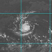
Tropical Storm Fabio was a short-lived tropical cyclone
that contributed to a period of heavy rainfall in Hawaii. The fourth named storm of the 2006 Pacific hurricane season
, Fabio developed from a tropical wave
on July 31 off the southwest coast of Mexico. It maintained a steady westward track throughout its duration, attaining peak winds of 50 mph (85 km/h) before weakening due to wind shear
and dry air. The remnants of Fabio passed near Hawaii
on August 7 after dissipating the previous day, though no significant damage or deaths were reported. However, rainfall from the system caused flash flooding and left 24 hikers stranded and in need of rescue by helicopter.
moved off the west coast of Africa on July 15. It tracked westward across the Atlantic Ocean and Caribbean Sea, generating limited thunderstorms along its path. The wave crossed Central America into the eastern Pacific Ocean around July 25, and three days later developed a weak low pressure area
about 515 miles (835 km) southwest of Manzanillo
, Colima
. The system developed an area of convection
, which gradually organized over the next few days. By July 30, the National Hurricane Center
(NHC) began noting the potential for tropical cyclogenesis
. Late on July 31, the system acquired enough persistent deep convection to be designated a tropical depression, while located about 980 miles southwest of the southern tip of the Baja California peninsula
.
Upon becoming a tropical cyclone, the depression was moving westward, influenced by a mid-level ridge
to its north. Within six hours of developing, it attained tropical storm status and was named Fabio by the NHC. Located within an environment only marginally favorable for intensification, Fabio was forecast to strengthen only slightly. The convection organized into curved rainbands on August 1, and with its increased organization, the storm attained peak winds of 50 mph (85 km/h). Tropical Storm Fabio maintained its peak intensity for about 24 hours, during which its convection became shifted to the north of the circulation due to increased wind shear
. By August 2, continued shear and increased dry air caused the convection to diminish greatly, before thunderstorms later increased to the west of the center. Later that day, the convection again decreased, leaving the circulation exposed from the thunderstorm activity; by that point, Fabio had weakened to tropical depression status. After the cyclone was unable to regenerate any significant convection for about 24 hours, the NHC declared Fabio a remnant low early on August 4. The low continued westward, degenerating into an open trough
on August 6 about 450 mi (725 km) southeast of Hilo, Hawaii. The remnants moved across much of Hawaii
on August 7, bringing locally heavy rainfall.
 As a tropical cyclone, Fabio did not affect land. However, moisture from the remnant trough of low pressure combined with an upper-level low to produce thunderstorms and heavy rainfall across much of Hawaii
. In Glenwood on the island of Hawaii
, the system produced 2.89 inches (73 mm) of rainfall in one day; this was the highest daily rainfall total for the month on the island. The heaviest rainfall associated with the system fell on Mount Waiʻaleʻale on the island of Kauai
, where 15.08 inches (383 mm) of rainfall fell in a 24 hour period; this 24 hour total alone was greater than all other monthly rainfall totals in the state. The rainfall led to flooding along the Hanalei River
, which forced the closure of the Kuhio Highway when a bridge was flooded. On Oahu
, the rainfall caused ponding on roadways and flooding along streams. One flooded stream stranded 24 hikers along a trail, who required rescue by helicopter.
Tropical cyclone
A tropical cyclone is a storm system characterized by a large low-pressure center and numerous thunderstorms that produce strong winds and heavy rain. Tropical cyclones strengthen when water evaporated from the ocean is released as the saturated air rises, resulting in condensation of water vapor...
that contributed to a period of heavy rainfall in Hawaii. The fourth named storm of the 2006 Pacific hurricane season
2006 Pacific hurricane season
The 2006 Pacific hurricane season was the most active Pacific hurricane season since 2000 producing 19 tropical storms or hurricanes. Eighteen developed within the National Hurricane Center area of warning responsibility, which is east of 140ºW, and one storm formed between 140ºW and the...
, Fabio developed from a tropical wave
Tropical wave
Tropical waves, easterly waves, or tropical easterly waves, also known as African easterly waves in the Atlantic region, are a type of atmospheric trough, an elongated area of relatively low air pressure, oriented north to south, which move from east to west across the tropics causing areas of...
on July 31 off the southwest coast of Mexico. It maintained a steady westward track throughout its duration, attaining peak winds of 50 mph (85 km/h) before weakening due to wind shear
Wind shear
Wind shear, sometimes referred to as windshear or wind gradient, is a difference in wind speed and direction over a relatively short distance in the atmosphere...
and dry air. The remnants of Fabio passed near Hawaii
Hawaii
Hawaii is the newest of the 50 U.S. states , and is the only U.S. state made up entirely of islands. It is the northernmost island group in Polynesia, occupying most of an archipelago in the central Pacific Ocean, southwest of the continental United States, southeast of Japan, and northeast of...
on August 7 after dissipating the previous day, though no significant damage or deaths were reported. However, rainfall from the system caused flash flooding and left 24 hikers stranded and in need of rescue by helicopter.
Meteorological history
A tropical waveTropical wave
Tropical waves, easterly waves, or tropical easterly waves, also known as African easterly waves in the Atlantic region, are a type of atmospheric trough, an elongated area of relatively low air pressure, oriented north to south, which move from east to west across the tropics causing areas of...
moved off the west coast of Africa on July 15. It tracked westward across the Atlantic Ocean and Caribbean Sea, generating limited thunderstorms along its path. The wave crossed Central America into the eastern Pacific Ocean around July 25, and three days later developed a weak low pressure area
Low pressure area
A low-pressure area, or "low", is a region where the atmospheric pressure at sea level is below that of surrounding locations. Low-pressure systems form under areas of wind divergence which occur in upper levels of the troposphere. The formation process of a low-pressure area is known as...
about 515 miles (835 km) southwest of Manzanillo
Manzanillo, Colima
The name Manzanillo refers to the city as well as its surrounding municipality in the Mexican state of Colima. The city, located on the Pacific Ocean, contains Mexico's busiest port. Manzanillo was the third port created by the Spanish in the Pacific during the New Spain period...
, Colima
Colima
Colima is one of the 31 states which, with the Federal District, make up the 32 Federal Entities of Mexico. It shares its name with its capital and main city, Colima....
. The system developed an area of convection
Atmospheric convection
Atmospheric convection is the result of a parcel-environment instability, or temperature difference, layer in the atmosphere. Different lapse rates within dry and moist air lead to instability. Mixing of air during the day which expands the height of the planetary boundary layer leads to...
, which gradually organized over the next few days. By July 30, the National Hurricane Center
National Hurricane Center
The National Hurricane Center , located at Florida International University in Miami, Florida, is the division of the National Weather Service responsible for tracking and predicting weather systems within the tropics between the Prime Meridian and the 140th meridian west poleward to the 30th...
(NHC) began noting the potential for tropical cyclogenesis
Tropical cyclogenesis
Tropical cyclogenesis is the term that describes the development and strengthening of a tropical cyclone in the atmosphere. The mechanisms through which tropical cyclogenesis occurs are distinctly different from those through which mid-latitude cyclogenesis occurs...
. Late on July 31, the system acquired enough persistent deep convection to be designated a tropical depression, while located about 980 miles southwest of the southern tip of the Baja California peninsula
Baja California Peninsula
The Baja California peninsula , is a peninsula in northwestern Mexico. Its land mass separates the Pacific Ocean from the Gulf of California. The Peninsula extends from Mexicali, Baja California in the north to Cabo San Lucas, Baja California Sur in the south.The total area of the Baja California...
.
Upon becoming a tropical cyclone, the depression was moving westward, influenced by a mid-level ridge
Ridge (meteorology)
A ridge is an elongated region of relatively high atmospheric pressure, the opposite of a trough....
to its north. Within six hours of developing, it attained tropical storm status and was named Fabio by the NHC. Located within an environment only marginally favorable for intensification, Fabio was forecast to strengthen only slightly. The convection organized into curved rainbands on August 1, and with its increased organization, the storm attained peak winds of 50 mph (85 km/h). Tropical Storm Fabio maintained its peak intensity for about 24 hours, during which its convection became shifted to the north of the circulation due to increased wind shear
Wind shear
Wind shear, sometimes referred to as windshear or wind gradient, is a difference in wind speed and direction over a relatively short distance in the atmosphere...
. By August 2, continued shear and increased dry air caused the convection to diminish greatly, before thunderstorms later increased to the west of the center. Later that day, the convection again decreased, leaving the circulation exposed from the thunderstorm activity; by that point, Fabio had weakened to tropical depression status. After the cyclone was unable to regenerate any significant convection for about 24 hours, the NHC declared Fabio a remnant low early on August 4. The low continued westward, degenerating into an open trough
Trough (meteorology)
A trough is an elongated region of relatively low atmospheric pressure, often associated with fronts.Unlike fronts, there is not a universal symbol for a trough on a weather chart. The weather charts in some countries or regions mark troughs by a line. In the United States, a trough may be marked...
on August 6 about 450 mi (725 km) southeast of Hilo, Hawaii. The remnants moved across much of Hawaii
Hawaii
Hawaii is the newest of the 50 U.S. states , and is the only U.S. state made up entirely of islands. It is the northernmost island group in Polynesia, occupying most of an archipelago in the central Pacific Ocean, southwest of the continental United States, southeast of Japan, and northeast of...
on August 7, bringing locally heavy rainfall.
Preparations and impact
Hawaii
Hawaii is the newest of the 50 U.S. states , and is the only U.S. state made up entirely of islands. It is the northernmost island group in Polynesia, occupying most of an archipelago in the central Pacific Ocean, southwest of the continental United States, southeast of Japan, and northeast of...
. In Glenwood on the island of Hawaii
Hawaii (island)
The Island of Hawaii, also called the Big Island or Hawaii Island , is a volcanic island in the North Pacific Ocean...
, the system produced 2.89 inches (73 mm) of rainfall in one day; this was the highest daily rainfall total for the month on the island. The heaviest rainfall associated with the system fell on Mount Waiʻaleʻale on the island of Kauai
Kauai
Kauai or Kauai, known as Tauai in the ancient Kaua'i dialect, is geologically the oldest of the main Hawaiian Islands. With an area of , it is the fourth largest of the main islands in the Hawaiian archipelago, and the 21st largest island in the United States. Known also as the "Garden Isle",...
, where 15.08 inches (383 mm) of rainfall fell in a 24 hour period; this 24 hour total alone was greater than all other monthly rainfall totals in the state. The rainfall led to flooding along the Hanalei River
Hanalei River
The Hanalei River on the island of Kauai in Hawaii flows north from the eastern slopes Mount Waialeale for until entering the Pacific Ocean at Hanalei Bay as an estuary...
, which forced the closure of the Kuhio Highway when a bridge was flooded. On Oahu
Oahu
Oahu or Oahu , known as "The Gathering Place", is the third largest of the Hawaiian Islands and most populous of the islands in the U.S. state of Hawaii. The state capital Honolulu is located on the southeast coast...
, the rainfall caused ponding on roadways and flooding along streams. One flooded stream stranded 24 hikers along a trail, who required rescue by helicopter.
See also
- List of Hawaii hurricanes
- Other tropical cyclones named Fabio
- Timeline of the 2006 Pacific hurricane seasonTimeline of the 2006 Pacific hurricane seasonThe 2006 Pacific hurricane season was the most active since the 2000 season, producing produced 21 tropical depressions; 19 of which became tropical storms or hurricanes...
- List of storms in the 2006 Pacific hurricane season
External links
- The NHCNational Hurricane CenterThe National Hurricane Center , located at Florida International University in Miami, Florida, is the division of the National Weather Service responsible for tracking and predicting weather systems within the tropics between the Prime Meridian and the 140th meridian west poleward to the 30th...
's Tropical Storm Fabio advisories.