
.gif)
Tropical Depression Two-E (2006)
Encyclopedia
Tropical Depression Two-E in 2006 was a short-lived tropical cyclone
that brought heavy rainfall to southwestern Mexico. It was the only cyclone during the month in the eastern North Pacific Ocean
, forming on June 3 from a tropical wave
. The depression initially moved northeastward, threatening the Mexican states of Michoacán
and Guerrero
with a potential of it attaining tropical storm status. It remained a tropical depression, weakening due to land interaction and wind shear
, and on June 5 it dissipated just off the coast. Rainfall from the depression peaked at 19.1 inch
es (486 mm
) in Acapulco
, which resulted in mudslides and flooding. A total of 42 houses were flooded, and 72 people were forced to leave their homes due to the storm; no deaths were reported.
off the southern coast of Mexico in late May 2006. An area of convection was associated with the wave, and forecasters at the National Hurricane Center
(NHC) remarked that environmental conditions favored gradual development
. The system, which was enhanced by the Intertropical Convergence Zone
(ITCZ), drifted northward with an anticyclone
to its east and west. On June 1, the convection became more concentrated, and by early the next day it developed a low pressure area
; by that time, it began a steady northwestward track.
An upper-level anticyclone north of the system provided a more favorable environment for organization, allowing the convection to organize into banding features. The system also developed good outflow
, though initially the surface circulation was too elongated for it to be considered a tropical cyclone. Early on June 3, the nearby anticyclone moved northeastward, which increased wind shear
over the system and caused it briefly to become less-organized. However, convection increased over the center, and at 1500 UTC
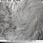
on June 3 the NHC classified the system as Tropical Depression Two-E about 140 mi
(240 km
) southwest of Zihuatanejo
, Guerrero
; the upgrade was due to the system developing sufficiently organized convection, as well as a closed surface circulation.
Upon being classified as a tropical cyclone, the depression was in an area not favorable for significant strengthening, due to land interaction and wind shear. It was tracking steadily northeastward, and as it moved closer to the coastline, the center of the depression was difficult to locate. However, the overall organization briefly improved, and in one forecast the depression was predicted to attain tropical storm status. Early on June 4, convection weakened significantly, leaving the center partially exposed. Continued wind shear brought most of the associated thunderstorm activity onshore southwestern Mexico while the center of the depression remained just offshore. Late on June 4, the circulation accelerated away from the deep convection as it passed a short distance south of Acapulco. Early on June 5, the circulation dissipated, and later that night the remnants moved inland.
 Due to uncertainty in whether the depression would attain tropical storm status or not, the government of Mexico
issued a tropical storm warning
from Punta San Telmo, Michoacán
to Acapulco
, Guerrero
. Prior to affecting the coastline, the Mexican meteorological agency
issued a heavy rainfall advisory, also mentioning the potential for flooding and mudslides, for the states of Jalisco
, Colima
, Michoacán, Guerrero, and Oaxaca
. Officials prepared 21 shelters in the region.
The depression produced heavy rainfall along the coastline, including a total of 19.1 inch
es (486 mm
) measured in a 48 hour period in Acapulco. Totals of over 2 inches (50 mm) spread across much of Guerrero and Oaxaca, causing flash flood
ing and mudslides. The storm partially flooded about 40 houses, and a total of 72 people were forced to leave their homes. In Acapulco, floodwaters washed trash from street corners onto the beaches. Elsewhere in Guerrero, the flooding and mudslides blocked several highways, which stranded dozens of vehicles. The wall of a prison collapsed due to the rainfall. Also in Acapulco, the rainfall downed trees and power lines, causing power outages and sparking a fire when a transformer exploded. No deaths were reported.
Tropical cyclone
A tropical cyclone is a storm system characterized by a large low-pressure center and numerous thunderstorms that produce strong winds and heavy rain. Tropical cyclones strengthen when water evaporated from the ocean is released as the saturated air rises, resulting in condensation of water vapor...
that brought heavy rainfall to southwestern Mexico. It was the only cyclone during the month in the eastern North Pacific Ocean
Pacific Ocean
The Pacific Ocean is the largest of the Earth's oceanic divisions. It extends from the Arctic in the north to the Southern Ocean in the south, bounded by Asia and Australia in the west, and the Americas in the east.At 165.2 million square kilometres in area, this largest division of the World...
, forming on June 3 from a tropical wave
Tropical wave
Tropical waves, easterly waves, or tropical easterly waves, also known as African easterly waves in the Atlantic region, are a type of atmospheric trough, an elongated area of relatively low air pressure, oriented north to south, which move from east to west across the tropics causing areas of...
. The depression initially moved northeastward, threatening the Mexican states of Michoacán
Michoacán
Michoacán officially Estado Libre y Soberano de Michoacán de Ocampo is one of the 31 states which, with the Federal District, comprise the 32 Federal Entities of Mexico. It is divided in 113 municipalities and its capital city is Morelia...
and Guerrero
Guerrero
Guerrero officially Estado Libre y Soberano de Guerrero is one of the 31 states which, with the Federal District, comprise the 32 Federal Entities of Mexico. It is divided in 81 municipalities and its capital city is Chilpancingo....
with a potential of it attaining tropical storm status. It remained a tropical depression, weakening due to land interaction and wind shear
Wind shear
Wind shear, sometimes referred to as windshear or wind gradient, is a difference in wind speed and direction over a relatively short distance in the atmosphere...
, and on June 5 it dissipated just off the coast. Rainfall from the depression peaked at 19.1 inch
Inch
An inch is the name of a unit of length in a number of different systems, including Imperial units, and United States customary units. There are 36 inches in a yard and 12 inches in a foot...
es (486 mm
Millimetre
The millimetre is a unit of length in the metric system, equal to one thousandth of a metre, which is the SI base unit of length....
) in Acapulco
Acapulco
Acapulco is a city, municipality and major sea port in the state of Guerrero on the Pacific coast of Mexico, southwest from Mexico City. Acapulco is located on a deep, semi-circular bay and has been a port since the early colonial period of Mexico’s history...
, which resulted in mudslides and flooding. A total of 42 houses were flooded, and 72 people were forced to leave their homes due to the storm; no deaths were reported.
Meteorological history
The tropical depression originated from a tropical waveTropical wave
Tropical waves, easterly waves, or tropical easterly waves, also known as African easterly waves in the Atlantic region, are a type of atmospheric trough, an elongated area of relatively low air pressure, oriented north to south, which move from east to west across the tropics causing areas of...
off the southern coast of Mexico in late May 2006. An area of convection was associated with the wave, and forecasters at the National Hurricane Center
National Hurricane Center
The National Hurricane Center , located at Florida International University in Miami, Florida, is the division of the National Weather Service responsible for tracking and predicting weather systems within the tropics between the Prime Meridian and the 140th meridian west poleward to the 30th...
(NHC) remarked that environmental conditions favored gradual development
Tropical cyclogenesis
Tropical cyclogenesis is the term that describes the development and strengthening of a tropical cyclone in the atmosphere. The mechanisms through which tropical cyclogenesis occurs are distinctly different from those through which mid-latitude cyclogenesis occurs...
. The system, which was enhanced by the Intertropical Convergence Zone
Intertropical Convergence Zone
The Intertropical Convergence Zone , known by sailors as The Doldrums, is the area encircling the earth near the equator where winds originating in the northern and southern hemispheres come together....
(ITCZ), drifted northward with an anticyclone
Anticyclone
An anticyclone is a weather phenomenon defined by the United States' National Weather Service's glossary as "[a] large-scale circulation of winds around a central region of high atmospheric pressure, clockwise in the Northern Hemisphere, counterclockwise in the Southern Hemisphere"...
to its east and west. On June 1, the convection became more concentrated, and by early the next day it developed a low pressure area
Low pressure area
A low-pressure area, or "low", is a region where the atmospheric pressure at sea level is below that of surrounding locations. Low-pressure systems form under areas of wind divergence which occur in upper levels of the troposphere. The formation process of a low-pressure area is known as...
; by that time, it began a steady northwestward track.
An upper-level anticyclone north of the system provided a more favorable environment for organization, allowing the convection to organize into banding features. The system also developed good outflow
Outflow (meteorology)
Outflow, in meteorology, is air that flows outwards from a storm system. It is associated with ridging, or anticyclonic flow. In the low levels of the troposphere, outflow radiates from thunderstorms in the form of a wedge of rain-cooled air, which is visible as a thin rope-like cloud on weather...
, though initially the surface circulation was too elongated for it to be considered a tropical cyclone. Early on June 3, the nearby anticyclone moved northeastward, which increased wind shear
Wind shear
Wind shear, sometimes referred to as windshear or wind gradient, is a difference in wind speed and direction over a relatively short distance in the atmosphere...
over the system and caused it briefly to become less-organized. However, convection increased over the center, and at 1500 UTC
Coordinated Universal Time
Coordinated Universal Time is the primary time standard by which the world regulates clocks and time. It is one of several closely related successors to Greenwich Mean Time. Computer servers, online services and other entities that rely on having a universally accepted time use UTC for that purpose...
on June 3 the NHC classified the system as Tropical Depression Two-E about 140 mi
Mile
A mile is a unit of length, most commonly 5,280 feet . The mile of 5,280 feet is sometimes called the statute mile or land mile to distinguish it from the nautical mile...
(240 km
Kilometre
The kilometre is a unit of length in the metric system, equal to one thousand metres and is therefore exactly equal to the distance travelled by light in free space in of a second...
) southwest of Zihuatanejo
Zihuatanejo
Zihuatanejo or Ixtapa-Zihuatanejo, is the fourth-largest city in the Mexican state of Guerrero. Politically the city belongs to the municipality of Zihuatanejo de Azueta in the western part of Guerrero, but both are commonly referred to as Zihuatanejo...
, Guerrero
Guerrero
Guerrero officially Estado Libre y Soberano de Guerrero is one of the 31 states which, with the Federal District, comprise the 32 Federal Entities of Mexico. It is divided in 81 municipalities and its capital city is Chilpancingo....
; the upgrade was due to the system developing sufficiently organized convection, as well as a closed surface circulation.
Upon being classified as a tropical cyclone, the depression was in an area not favorable for significant strengthening, due to land interaction and wind shear. It was tracking steadily northeastward, and as it moved closer to the coastline, the center of the depression was difficult to locate. However, the overall organization briefly improved, and in one forecast the depression was predicted to attain tropical storm status. Early on June 4, convection weakened significantly, leaving the center partially exposed. Continued wind shear brought most of the associated thunderstorm activity onshore southwestern Mexico while the center of the depression remained just offshore. Late on June 4, the circulation accelerated away from the deep convection as it passed a short distance south of Acapulco. Early on June 5, the circulation dissipated, and later that night the remnants moved inland.
Preparations and impact
Mexico
The United Mexican States , commonly known as Mexico , is a federal constitutional republic in North America. It is bordered on the north by the United States; on the south and west by the Pacific Ocean; on the southeast by Guatemala, Belize, and the Caribbean Sea; and on the east by the Gulf of...
issued a tropical storm warning
Tropical cyclone warnings and watches
Warnings and watches are two levels of alert issued by national weather forecasting bodies to coastal areas threatened by the imminent approach of a tropical cyclone of tropical storm or hurricane intensity. They are notices to the local population and civil authorities to make appropriate...
from Punta San Telmo, Michoacán
Michoacán
Michoacán officially Estado Libre y Soberano de Michoacán de Ocampo is one of the 31 states which, with the Federal District, comprise the 32 Federal Entities of Mexico. It is divided in 113 municipalities and its capital city is Morelia...
to Acapulco
Acapulco
Acapulco is a city, municipality and major sea port in the state of Guerrero on the Pacific coast of Mexico, southwest from Mexico City. Acapulco is located on a deep, semi-circular bay and has been a port since the early colonial period of Mexico’s history...
, Guerrero
Guerrero
Guerrero officially Estado Libre y Soberano de Guerrero is one of the 31 states which, with the Federal District, comprise the 32 Federal Entities of Mexico. It is divided in 81 municipalities and its capital city is Chilpancingo....
. Prior to affecting the coastline, the Mexican meteorological agency
Servicio Meteorológico Nacional
The Servicio Meteorológico Nacional is Mexico's national weather organization. It collects data and issues forecasts, advisories, and warnings for the entire country.-History:...
issued a heavy rainfall advisory, also mentioning the potential for flooding and mudslides, for the states of Jalisco
Jalisco
Jalisco officially Estado Libre y Soberano de Jalisco is one of the 31 states which, with the Federal District, comprise the 32 Federal Entities of Mexico. It is located in Western Mexico and divided in 125 municipalities and its capital city is Guadalajara.It is one of the more important states...
, Colima
Colima
Colima is one of the 31 states which, with the Federal District, make up the 32 Federal Entities of Mexico. It shares its name with its capital and main city, Colima....
, Michoacán, Guerrero, and Oaxaca
Oaxaca
Oaxaca , , officially Estado Libre y Soberano de Oaxaca is one of the 31 states which, along with the Federal District, comprise the 32 federative entities of Mexico. It is divided into 571 municipalities; of which 418 are governed by the system of customs and traditions...
. Officials prepared 21 shelters in the region.
The depression produced heavy rainfall along the coastline, including a total of 19.1 inch
Inch
An inch is the name of a unit of length in a number of different systems, including Imperial units, and United States customary units. There are 36 inches in a yard and 12 inches in a foot...
es (486 mm
Millimetre
The millimetre is a unit of length in the metric system, equal to one thousandth of a metre, which is the SI base unit of length....
) measured in a 48 hour period in Acapulco. Totals of over 2 inches (50 mm) spread across much of Guerrero and Oaxaca, causing flash flood
Flash flood
A flash flood is a rapid flooding of geomorphic low-lying areas—washes, rivers, dry lakes and basins. It may be caused by heavy rain associated with a storm, hurricane, or tropical storm or meltwater from ice or snow flowing over ice sheets or snowfields...
ing and mudslides. The storm partially flooded about 40 houses, and a total of 72 people were forced to leave their homes. In Acapulco, floodwaters washed trash from street corners onto the beaches. Elsewhere in Guerrero, the flooding and mudslides blocked several highways, which stranded dozens of vehicles. The wall of a prison collapsed due to the rainfall. Also in Acapulco, the rainfall downed trees and power lines, causing power outages and sparking a fire when a transformer exploded. No deaths were reported.