
.gif)
Hurricane John (2006)
Encyclopedia
Hurricane John was the eleventh named storm
, seventh hurricane, and fifth major hurricane of the 2006 Pacific hurricane season
. Hurricane John developed on August 28 from a tropical wave
to the south of Mexico. Favorable conditions allowed the storm to intensify quickly, and it attained peak winds of 135 mph (215 km/h) on August 30. Eyewall
replacement cycles and land interaction with western Mexico weakened the hurricane, and John made landfall on southeastern Baja California Sur
with winds of 110 mph (180 km/h) on September 1. It slowly weakened as it moved northwestward through the Baja California peninsula, and dissipated on September 4. Moisture from the remnants of the storm entered the southwest United States.
The hurricane threatened large portions of the western coastline of Mexico
, resulting in the evacuation of tens of thousands of people. In coastal portions of western Mexico, strong winds downed trees, while heavy rain resulted in mudslides. Hurricane John caused moderate damage on the Baja California peninsula, including the destruction of more than 200 houses and thousands of flimsy shacks. The hurricane killed five people in Mexico, and damage totaled $663 million (2006 MXN
, $60.8 million 2006 USD
). In the southwest United States, moisture from the remnants of John produced heavy rainfall. The rainfall aided drought conditions in portions of northern Texas
, although it was detrimental in locations that had received above-normal rainfall throughout the year.
that would become John moved off the coast of Africa
on August 17. It entered the eastern Pacific Ocean
on August 24, and quickly showed signs of organization
. That night, Dvorak classifications
were initiated on the system while it was located just west of Costa Rica
, and it moved west-northwestward at 10–15 mph (15–25 km/h). Conditions appeared favorable for further development, and convection increased late on August 26 over the area of low pressure. Early on August 27, the system became much better organized about 250 miles (400 km) south-southwest of Guatemala, although convection remained minimal. Early on August 28, banding increased within its organizing convection, and the system developed into Tropical Depression Eleven-E.
Due to low amounts of vertical shear, very warm waters, and abundant moisture, steady intensification was forecast, and the depression strengthened to Tropical Storm John later on August 28. Deep convection continued to develop over the storm, while an eye feature developed within the expanding central dense overcast. The storm continued to intensify, and John attained hurricane status on August 29 while 190 miles (305 km) south-southeast of Acapulco. Banding features continued to increase as the hurricane moved west-northwestward around the southwest periphery of a mid- to upper-level ridge over northern Mexico
. The hurricane underwent rapid intensification, and John attained major hurricane status 12 hours after becoming a hurricane. Shortly thereafter, the eye became obscured, and the intensity remained at 115 mph (185 km/h) due to an eyewall
replacement cycle. Another eye formed, and based on Reconnaissance
data, the hurricane attained Category 4 status on the Saffir-Simpson Hurricane Scale
on August 30 about 160 miles (260 km) west of Acapulco, or 95 miles (155 km) south of Lázaro Cárdenas, Michoacán
. Hours later, the hurricane underwent another eyewall replacement cycle, and subsequently weakened to Category 3 status as it paralleled the Mexican coastline a short distance offshore.
 Due to land interaction and its eyewall replacement cycle, Hurricane John weakened to a 105 mph (170 km/h) hurricane by late on August 31, but restrengthened to a major hurricane shortly after as its eye became better defined. After completing another eyewall replacement cycle, the hurricane again weakened to Category 2 status, and on September 1 it made landfall on Cabo del Este on the southern tip of Baja California Sur
with winds of 110 mph (180 km/h). John passed near La Paz
as a weakening Category 1 hurricane on September 2, and weakened to a tropical storm shortly thereafter over land. John continued to weaken, and late on September 3 the system deteriorated to a tropical depression while still over land. By September 4, most of the convection decoupled from the circulation towards mainland Mexico, and a clear circulation had not been discernible for 24 hours. Based on the disorganization of the system, the National Hurricane Center issued its last advisory on the system.
and Zihuatanejo
closed the port to small ocean craft. Government officials in the state of Jalisco
declared a mandatory evacuation for 8,000 citizens in low-lying areas to 900 temporary shelters. Temporary shelters were also set up near Acapulco. The state of Michoacán
was on a yellow alert, the middle of a five-level alert system. Carnival Cruise Lines
diverted the path of one cruise ship traveling along the Pacific waters off Mexico.
On August 31, the Baja California Sur
state government ordered the evacuation of more than 10,000 residents. Those who refused to follow the evacuation order would have been forced to evacuate by the army. Shelters were set up to allow local residents and tourists to ride out the storm. Just weeks after a major flood in the area, officials evacuated hundreds of citizens in Las Presas in northern Mexico
area near a dam. All public schools in the area were closed, as well.
The United States' National Weather Service
issued flood watches and warnings for portions of Texas
and the southern two-thirds of New Mexico
.
 The powerful winds of Hurricane John produced heavy surf and downed trees near Acapulco. The hurricane produced a 10 foot (3 m) storm surge in Acapulco that flooded coastal roads. In addition, John caused heavy rainfall along the western coast of Mexico, peaking at 12.5 inches (317.5 mm) in Los Planes, Jalisco. The rainfall resulted in mudslides in the Costa Chica
region of Guerrero
, leaving around 70 communities isolated.
In La Paz
, capital of Baja California Sur
, the hurricane downed 40 power poles. Authorities cut off the power supply to the city to prevent electrocutions from downed wires. Strong winds downed trees and destroyed many advertisement signs. Heavy rainfall totaling more than 20 inches (500 mm) in isolated areas resulted in ankle-deep flooding, closing many roads in addition to the airport in La Paz. In La Paz, 300 families received damage to their homes, with another 200 families left homeless after their houses were destroyed. The combination of winds and rain destroyed thousands of flimsy houses across the region. The rainfall also destroyed large areas of crops, and also killed many livestock. The rainfall caused the Iguagil dam in Comondú to overflow, isolating 15 towns due to 4 feet (1.5 m) floodwaters. In the coastal city of Mulegé
, flash flooding caused widespread damage throughout the town and the death of a United States citizen. More than 250 homes were damaged or destroyed in the town, leaving many people homeless. Severe flooding blocked portions of Federal Highway 1
, and also caused damage to an aqueduct in the region.
In all, Hurricane John destroyed hundreds of houses and blew off the roofs of 160 houses on the Baja California peninsula
. Five people were killed, and damage in Mexico amounted to $663 million (2006 MXN
, $60.8 million 2006 USD
).
In Ciudad Juárez
, Chihuahua, across the U.S. border from El Paso, Texas
, rainfall from the storm's remnants flooded 20 neighborhoods, downed power lines, and resulted in several traffic accidents. Rainfall from John, combined with continual precipitation during the two weeks before the storm, left thousands of people homeless.
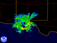 Moisture from the remnants of John combined with an approaching cold front
to produce moderate amounts of rainfall across the southwest United States, including a total of 8 inches (200 mm) in Whitharral
and more than 3 inches (75 mm) in El Paso, Texas
. The rainfall flooded many roads in southwestern Texas, including a ½ mile (800 m) portion of Interstate 10
in El Paso. A slick runway at El Paso International Airport delayed a Continental Airlines
jet when its tires were stuck in mud. Rainfall from John in El Paso, combined with an unusually wet year, resulted in twice the normal annual rainfall, and caused 2006 to be the ninth wettest year on record by September. Damage totaled about $100,000 (2006 USD) in the El Paso area from the precipitation. In northern Texas, the rainfall alleviated a severe drought, caused the Double Mountain Fork Brazos River
to swell and Lake Alan Henry to overflow. The Texas Department of Transportation closed numerous roads due to flooding from the precipitation, including a portion of U.S. Route 385 near Levelland
. Several other roads were washed out.
Moisture derived from John also produced rainfall across southern New Mexico, peaking at 5.25 inches (133 mm) at Ruidoso
. The rainfall overflowed rivers, forcing people to evacuate along the Rio Ruidoso
. The rainfall also caused isolated road flooding. Rainfall in New Mexico canceled an annual wine festival in Las Cruces and caused muddy conditions at the All American Futurity at the Ruidoso Downs
, the biggest day of horse racing in New Mexico. Flooding was severe in Mesquite
, Hatch
, and Rincon
, where many homes experienced 4 feet (1.5 m) of flooding and mud. Some homeowners lost all they owned. Tropical moisture from the storm also produced rainfall in Arizona
and southern California
. In California, the rainfall produced eight separate mudslides, trapping 19 vehicles but causing no injuries.
, gas supply, which was necessary to run generators, was low, drinking water was gone, and the airstrip was covered with mud. Many homeless residents initially stayed with friends or in government-run shelters. Throughout the Baja California peninsula, thousands remained without water or electricity by two days after the storm, although a pilot from Phoenix
prepared to fly to the disaster area with 100 gallons (380 litres) of water. Other pilots were expected to execute similar flights, as well. The office of Baja California Sur Tourism stated that minimal damage occurred to the tourism infrastructure, with only minimal delays to airports, roads, and maritime facilities. The Episcopal Relief and Development delivered food, clothing, medicine, and transportation to about 100 families, and gave mattresses to about 80 families.
Many residents in Tucson
, including more than 50 students, delivered supplies to flood victims in New Mexico, including clothing and other donations.
Tropical cyclone
A tropical cyclone is a storm system characterized by a large low-pressure center and numerous thunderstorms that produce strong winds and heavy rain. Tropical cyclones strengthen when water evaporated from the ocean is released as the saturated air rises, resulting in condensation of water vapor...
, seventh hurricane, and fifth major hurricane of the 2006 Pacific hurricane season
2006 Pacific hurricane season
The 2006 Pacific hurricane season was the most active Pacific hurricane season since 2000 producing 19 tropical storms or hurricanes. Eighteen developed within the National Hurricane Center area of warning responsibility, which is east of 140ºW, and one storm formed between 140ºW and the...
. Hurricane John developed on August 28 from a tropical wave
Tropical wave
Tropical waves, easterly waves, or tropical easterly waves, also known as African easterly waves in the Atlantic region, are a type of atmospheric trough, an elongated area of relatively low air pressure, oriented north to south, which move from east to west across the tropics causing areas of...
to the south of Mexico. Favorable conditions allowed the storm to intensify quickly, and it attained peak winds of 135 mph (215 km/h) on August 30. Eyewall
Eye (cyclone)
The eye is a region of mostly calm weather found at the center of strong tropical cyclones. The eye of a storm is a roughly circular area and typically 30–65 km in diameter. It is surrounded by the eyewall, a ring of towering thunderstorms where the second most severe weather of a cyclone...
replacement cycles and land interaction with western Mexico weakened the hurricane, and John made landfall on southeastern Baja California Sur
Baja California Sur
Baja California Sur , is one of the 31 states which, with the Federal District, comprise the 32 Federal Entities of Mexico. Before becoming a state on October 8, 1974, the area was known as the South Territory of Baja California. It has an area of , or 3.57% of the land mass of Mexico and comprises...
with winds of 110 mph (180 km/h) on September 1. It slowly weakened as it moved northwestward through the Baja California peninsula, and dissipated on September 4. Moisture from the remnants of the storm entered the southwest United States.
The hurricane threatened large portions of the western coastline of Mexico
Mexico
The United Mexican States , commonly known as Mexico , is a federal constitutional republic in North America. It is bordered on the north by the United States; on the south and west by the Pacific Ocean; on the southeast by Guatemala, Belize, and the Caribbean Sea; and on the east by the Gulf of...
, resulting in the evacuation of tens of thousands of people. In coastal portions of western Mexico, strong winds downed trees, while heavy rain resulted in mudslides. Hurricane John caused moderate damage on the Baja California peninsula, including the destruction of more than 200 houses and thousands of flimsy shacks. The hurricane killed five people in Mexico, and damage totaled $663 million (2006 MXN
Mexican peso
The peso is the currency of Mexico. Modern peso and dollar currencies have a common origin in the 15th–19th century Spanish dollar, most continuing to use its sign, "$". The Mexican peso is the 12th most traded currency in the world, the third most traded in the Americas, and by far the most...
, $60.8 million 2006 USD
United States dollar
The United States dollar , also referred to as the American dollar, is the official currency of the United States of America. It is divided into 100 smaller units called cents or pennies....
). In the southwest United States, moisture from the remnants of John produced heavy rainfall. The rainfall aided drought conditions in portions of northern Texas
Texas
Texas is the second largest U.S. state by both area and population, and the largest state by area in the contiguous United States.The name, based on the Caddo word "Tejas" meaning "friends" or "allies", was applied by the Spanish to the Caddo themselves and to the region of their settlement in...
, although it was detrimental in locations that had received above-normal rainfall throughout the year.
Meteorological history
The tropical waveTropical wave
Tropical waves, easterly waves, or tropical easterly waves, also known as African easterly waves in the Atlantic region, are a type of atmospheric trough, an elongated area of relatively low air pressure, oriented north to south, which move from east to west across the tropics causing areas of...
that would become John moved off the coast of Africa
Africa
Africa is the world's second largest and second most populous continent, after Asia. At about 30.2 million km² including adjacent islands, it covers 6% of the Earth's total surface area and 20.4% of the total land area...
on August 17. It entered the eastern Pacific Ocean
Pacific Ocean
The Pacific Ocean is the largest of the Earth's oceanic divisions. It extends from the Arctic in the north to the Southern Ocean in the south, bounded by Asia and Australia in the west, and the Americas in the east.At 165.2 million square kilometres in area, this largest division of the World...
on August 24, and quickly showed signs of organization
Tropical cyclogenesis
Tropical cyclogenesis is the term that describes the development and strengthening of a tropical cyclone in the atmosphere. The mechanisms through which tropical cyclogenesis occurs are distinctly different from those through which mid-latitude cyclogenesis occurs...
. That night, Dvorak classifications
Dvorak technique
The Dvorak technique is a widely used system to subjectively estimate tropical cyclone intensity based solely on visible and infrared satellite images. Several agencies issue Dvorak intensity numbers for cyclones of sufficient intensity...
were initiated on the system while it was located just west of Costa Rica
Costa Rica
Costa Rica , officially the Republic of Costa Rica is a multilingual, multiethnic and multicultural country in Central America, bordered by Nicaragua to the north, Panama to the southeast, the Pacific Ocean to the west and the Caribbean Sea to the east....
, and it moved west-northwestward at 10–15 mph (15–25 km/h). Conditions appeared favorable for further development, and convection increased late on August 26 over the area of low pressure. Early on August 27, the system became much better organized about 250 miles (400 km) south-southwest of Guatemala, although convection remained minimal. Early on August 28, banding increased within its organizing convection, and the system developed into Tropical Depression Eleven-E.
Due to low amounts of vertical shear, very warm waters, and abundant moisture, steady intensification was forecast, and the depression strengthened to Tropical Storm John later on August 28. Deep convection continued to develop over the storm, while an eye feature developed within the expanding central dense overcast. The storm continued to intensify, and John attained hurricane status on August 29 while 190 miles (305 km) south-southeast of Acapulco. Banding features continued to increase as the hurricane moved west-northwestward around the southwest periphery of a mid- to upper-level ridge over northern Mexico
Mexico
The United Mexican States , commonly known as Mexico , is a federal constitutional republic in North America. It is bordered on the north by the United States; on the south and west by the Pacific Ocean; on the southeast by Guatemala, Belize, and the Caribbean Sea; and on the east by the Gulf of...
. The hurricane underwent rapid intensification, and John attained major hurricane status 12 hours after becoming a hurricane. Shortly thereafter, the eye became obscured, and the intensity remained at 115 mph (185 km/h) due to an eyewall
Eye (cyclone)
The eye is a region of mostly calm weather found at the center of strong tropical cyclones. The eye of a storm is a roughly circular area and typically 30–65 km in diameter. It is surrounded by the eyewall, a ring of towering thunderstorms where the second most severe weather of a cyclone...
replacement cycle. Another eye formed, and based on Reconnaissance
Hurricane Hunters
The Hurricane Hunters are aircraft that fly into tropical cyclones in the North Atlantic Ocean and Northeastern Pacific Ocean for the specific purpose of directly measuring weather data in and around those storms. In the United States, the Air Force, Navy, and NOAA units have all participated in...
data, the hurricane attained Category 4 status on the Saffir-Simpson Hurricane Scale
Saffir-Simpson Hurricane Scale
The Saffir–Simpson Hurricane Scale , or the Saffir–Simpson Hurricane Wind Scale , classifies hurricanes — Western Hemisphere tropical cyclones that exceed the intensities of tropical depressions and tropical storms — into five categories distinguished by the intensities of their sustained winds...
on August 30 about 160 miles (260 km) west of Acapulco, or 95 miles (155 km) south of Lázaro Cárdenas, Michoacán
Lázaro Cárdenas, Michoacán
Lázaro Cárdenas is a port city that with its surrounding municipality is located in the southern part of the Mexican state of Michoacán. It was formerly known as Los Llanitos, but changed its name as a tribute to Lázaro Cárdenas del Río, a Michoacán-born politician who was president of Mexico from...
. Hours later, the hurricane underwent another eyewall replacement cycle, and subsequently weakened to Category 3 status as it paralleled the Mexican coastline a short distance offshore.
Baja California Sur
Baja California Sur , is one of the 31 states which, with the Federal District, comprise the 32 Federal Entities of Mexico. Before becoming a state on October 8, 1974, the area was known as the South Territory of Baja California. It has an area of , or 3.57% of the land mass of Mexico and comprises...
with winds of 110 mph (180 km/h). John passed near La Paz
La Paz, Baja California Sur
La Paz is the capital city of the Mexican state of Baja California Sur and an important regional commercial center. The city had a 2010 census population of 215,178 persons, but its metropolitan population is somewhat larger because of surrounding towns like el Centenario, el Zacatal and San Pedro...
as a weakening Category 1 hurricane on September 2, and weakened to a tropical storm shortly thereafter over land. John continued to weaken, and late on September 3 the system deteriorated to a tropical depression while still over land. By September 4, most of the convection decoupled from the circulation towards mainland Mexico, and a clear circulation had not been discernible for 24 hours. Based on the disorganization of the system, the National Hurricane Center issued its last advisory on the system.
Preparations
The Mexican army and emergency services were stationed near the coast, while classes at public schools in and around Acapulco were canceled. Officials in Acapulco advised residents in low-lying areas to be on alert, and also urged fishermen to return to harbor. Authorities in the twin resort cities of IxtapaIxtapa
Ixtapa is a beach resort in the municipality of Zihuatanejo de Azueta, in the Mexican state of Guerrero. It is located to the northwest of the municipal seat, Zihuatanejo, and some northwest of Acapulco....
and Zihuatanejo
Zihuatanejo
Zihuatanejo or Ixtapa-Zihuatanejo, is the fourth-largest city in the Mexican state of Guerrero. Politically the city belongs to the municipality of Zihuatanejo de Azueta in the western part of Guerrero, but both are commonly referred to as Zihuatanejo...
closed the port to small ocean craft. Government officials in the state of Jalisco
Jalisco
Jalisco officially Estado Libre y Soberano de Jalisco is one of the 31 states which, with the Federal District, comprise the 32 Federal Entities of Mexico. It is located in Western Mexico and divided in 125 municipalities and its capital city is Guadalajara.It is one of the more important states...
declared a mandatory evacuation for 8,000 citizens in low-lying areas to 900 temporary shelters. Temporary shelters were also set up near Acapulco. The state of Michoacán
Michoacán
Michoacán officially Estado Libre y Soberano de Michoacán de Ocampo is one of the 31 states which, with the Federal District, comprise the 32 Federal Entities of Mexico. It is divided in 113 municipalities and its capital city is Morelia...
was on a yellow alert, the middle of a five-level alert system. Carnival Cruise Lines
Carnival Cruise Lines
Carnival Cruise Lines is a British-American owned cruise line, based in Doral, Florida, a suburb of Miami in the United States. Originally an independent company founded in 1972 by Ted Arison, the company is now one of eleven cruise ship brands owned and operated by Carnival Corporation & plc...
diverted the path of one cruise ship traveling along the Pacific waters off Mexico.
On August 31, the Baja California Sur
Baja California Sur
Baja California Sur , is one of the 31 states which, with the Federal District, comprise the 32 Federal Entities of Mexico. Before becoming a state on October 8, 1974, the area was known as the South Territory of Baja California. It has an area of , or 3.57% of the land mass of Mexico and comprises...
state government ordered the evacuation of more than 10,000 residents. Those who refused to follow the evacuation order would have been forced to evacuate by the army. Shelters were set up to allow local residents and tourists to ride out the storm. Just weeks after a major flood in the area, officials evacuated hundreds of citizens in Las Presas in northern Mexico
Mexico
The United Mexican States , commonly known as Mexico , is a federal constitutional republic in North America. It is bordered on the north by the United States; on the south and west by the Pacific Ocean; on the southeast by Guatemala, Belize, and the Caribbean Sea; and on the east by the Gulf of...
area near a dam. All public schools in the area were closed, as well.
The United States' National Weather Service
National Weather Service
The National Weather Service , once known as the Weather Bureau, is one of the six scientific agencies that make up the National Oceanic and Atmospheric Administration of the United States government...
issued flood watches and warnings for portions of Texas
Texas
Texas is the second largest U.S. state by both area and population, and the largest state by area in the contiguous United States.The name, based on the Caddo word "Tejas" meaning "friends" or "allies", was applied by the Spanish to the Caddo themselves and to the region of their settlement in...
and the southern two-thirds of New Mexico
New Mexico
New Mexico is a state located in the southwest and western regions of the United States. New Mexico is also usually considered one of the Mountain States. With a population density of 16 per square mile, New Mexico is the sixth-most sparsely inhabited U.S...
.
Mexico
Costa Chica of Guerrero
The Costa Chica is one of the seven regions into which the southern Mexican state of Guerrero is divided.It begins to the east of Acapulco and extends along the coast for as far as the border with Oaxaca, where the Costa Chica of Oaxaca begins.Similar to other parts of the southern Mexico, the...
region of Guerrero
Guerrero
Guerrero officially Estado Libre y Soberano de Guerrero is one of the 31 states which, with the Federal District, comprise the 32 Federal Entities of Mexico. It is divided in 81 municipalities and its capital city is Chilpancingo....
, leaving around 70 communities isolated.
In La Paz
La Paz, Baja California Sur
La Paz is the capital city of the Mexican state of Baja California Sur and an important regional commercial center. The city had a 2010 census population of 215,178 persons, but its metropolitan population is somewhat larger because of surrounding towns like el Centenario, el Zacatal and San Pedro...
, capital of Baja California Sur
Baja California Sur
Baja California Sur , is one of the 31 states which, with the Federal District, comprise the 32 Federal Entities of Mexico. Before becoming a state on October 8, 1974, the area was known as the South Territory of Baja California. It has an area of , or 3.57% of the land mass of Mexico and comprises...
, the hurricane downed 40 power poles. Authorities cut off the power supply to the city to prevent electrocutions from downed wires. Strong winds downed trees and destroyed many advertisement signs. Heavy rainfall totaling more than 20 inches (500 mm) in isolated areas resulted in ankle-deep flooding, closing many roads in addition to the airport in La Paz. In La Paz, 300 families received damage to their homes, with another 200 families left homeless after their houses were destroyed. The combination of winds and rain destroyed thousands of flimsy houses across the region. The rainfall also destroyed large areas of crops, and also killed many livestock. The rainfall caused the Iguagil dam in Comondú to overflow, isolating 15 towns due to 4 feet (1.5 m) floodwaters. In the coastal city of Mulegé
Mulegé
Mulegé is an oasis town in the Mexican state of Baja California Sur, situated at the mouth of the Río de Santa Rosalía. It is the fourth-largest community in Mulegé Municipality...
, flash flooding caused widespread damage throughout the town and the death of a United States citizen. More than 250 homes were damaged or destroyed in the town, leaving many people homeless. Severe flooding blocked portions of Federal Highway 1
Mexican Federal Highway 1
Mexican Federal Highway No. 1 follows the length of the Baja California Peninsula from Cabo San Lucas , at the southern end to Tijuana in the north...
, and also caused damage to an aqueduct in the region.
In all, Hurricane John destroyed hundreds of houses and blew off the roofs of 160 houses on the Baja California peninsula
Baja California Peninsula
The Baja California peninsula , is a peninsula in northwestern Mexico. Its land mass separates the Pacific Ocean from the Gulf of California. The Peninsula extends from Mexicali, Baja California in the north to Cabo San Lucas, Baja California Sur in the south.The total area of the Baja California...
. Five people were killed, and damage in Mexico amounted to $663 million (2006 MXN
Mexican peso
The peso is the currency of Mexico. Modern peso and dollar currencies have a common origin in the 15th–19th century Spanish dollar, most continuing to use its sign, "$". The Mexican peso is the 12th most traded currency in the world, the third most traded in the Americas, and by far the most...
, $60.8 million 2006 USD
United States dollar
The United States dollar , also referred to as the American dollar, is the official currency of the United States of America. It is divided into 100 smaller units called cents or pennies....
).
In Ciudad Juárez
Ciudad Juárez
Ciudad Juárez , officially known today as Heroica Ciudad Juárez, but abbreviated Juárez and formerly known as El Paso del Norte, is a city and seat of the municipality of Juárez in the Mexican state of Chihuahua. Juárez's estimated population is 1.5 million people. The city lies on the Rio Grande...
, Chihuahua, across the U.S. border from El Paso, Texas
El Paso, Texas
El Paso, is a city in and the county seat of El Paso County, Texas, United States, and lies in far West Texas. In the 2010 census, the city had a population of 649,121. It is the sixth largest city in Texas and the 19th largest city in the United States...
, rainfall from the storm's remnants flooded 20 neighborhoods, downed power lines, and resulted in several traffic accidents. Rainfall from John, combined with continual precipitation during the two weeks before the storm, left thousands of people homeless.
United States
Surface weather analysis
Surface weather analysis is a special type of weather map that provides a view of weather elements over a geographical area at a specified time based on information from ground-based weather stations...
to produce moderate amounts of rainfall across the southwest United States, including a total of 8 inches (200 mm) in Whitharral
Whitharral, Texas
Whitharral is an unincorporated community in Hockley County, Texas, United States.-History:Whitharral was founded in 1924 after the sale of the Littlefield ranchlands. The town was named by an early settler by the name of Whitfield Harral, or possibly Harold Whitfield.A school was founded in 1925,...
and more than 3 inches (75 mm) in El Paso, Texas
El Paso, Texas
El Paso, is a city in and the county seat of El Paso County, Texas, United States, and lies in far West Texas. In the 2010 census, the city had a population of 649,121. It is the sixth largest city in Texas and the 19th largest city in the United States...
. The rainfall flooded many roads in southwestern Texas, including a ½ mile (800 m) portion of Interstate 10
Interstate 10
Interstate 10 is the fourth-longest Interstate Highway in the United States, after I-90, I-80, and I-40. It is the southernmost east–west, coast-to-coast Interstate Highway, although I-4 and I-8 are further south. It stretches from the Pacific Ocean at State Route 1 in Santa Monica,...
in El Paso. A slick runway at El Paso International Airport delayed a Continental Airlines
Continental Airlines
Continental Airlines was a major American airline now merged with United Airlines. On May 3, 2010, Continental Airlines, Inc. and UAL, Inc. announced a merger via a stock swap, and on October 1, 2010, the merger closed and UAL changed its name to United Continental Holdings, Inc...
jet when its tires were stuck in mud. Rainfall from John in El Paso, combined with an unusually wet year, resulted in twice the normal annual rainfall, and caused 2006 to be the ninth wettest year on record by September. Damage totaled about $100,000 (2006 USD) in the El Paso area from the precipitation. In northern Texas, the rainfall alleviated a severe drought, caused the Double Mountain Fork Brazos River
Double Mountain Fork Brazos River
The Double Mountain Fork Brazos River is an ephemeral, sandy-braided stream about long, heading on the Llano Estacado of West Texas about southeast of Tahoka, Texas, flowing east-northeast across the western Rolling Plains to join the Salt Fork, forming the Brazos River about west-northwest of...
to swell and Lake Alan Henry to overflow. The Texas Department of Transportation closed numerous roads due to flooding from the precipitation, including a portion of U.S. Route 385 near Levelland
Levelland, Texas
Levelland is a city in Hockley County, Texas, in the United States. As of the 2010 census, the city population was 13,542. It is the county seat of Hockley County. It is located on the Llano Estacado, west of Lubbock. Major industries include cotton farming and petroleum production...
. Several other roads were washed out.
Moisture derived from John also produced rainfall across southern New Mexico, peaking at 5.25 inches (133 mm) at Ruidoso
Ruidoso, New Mexico
Ruidoso is a village in Lincoln County, New Mexico, United States, adjacent to the Lincoln National Forest. The population was 8,029 at the 2010 census...
. The rainfall overflowed rivers, forcing people to evacuate along the Rio Ruidoso
Rio Ruidoso
The Rio Ruidoso is a long river located in the Sierra Blanca and Sacramento Mountains in Lincoln County and Otero County, New Mexico in the United States and is part of the Rio Ruidoso Watershed...
. The rainfall also caused isolated road flooding. Rainfall in New Mexico canceled an annual wine festival in Las Cruces and caused muddy conditions at the All American Futurity at the Ruidoso Downs
Ruidoso Downs (track)
Ruidoso Downs is a horse racing track in Ruidoso Downs, New Mexico. The track hosts both thoroughbred and quarter horse racing, notably the All American Futurity, the richest race in quarter horse racing.-External links:*...
, the biggest day of horse racing in New Mexico. Flooding was severe in Mesquite
Mesquite, New Mexico
Mesquite is a census-designated place in Doña Ana County, New Mexico, United States. The population was 948 at the 2000 census. It is part of the Las Cruces Metropolitan Statistical Area.-Geography:Mesquite is located at ....
, Hatch
Hatch, New Mexico
Hatch is a village in Doña Ana County, New Mexico, United States. The population was 1,673 at the 2000 census. It is part of the Las Cruces Metropolitan Statistical Area. The town is experiencing moderate growth, along with its outliers of Salem, Arrey, Derry, and Rincon...
, and Rincon
Rincon, New Mexico
Rincon is a census-designated place in Doña Ana County, New Mexico, in the United States. As of the 2000 census, the CDP population was 220...
, where many homes experienced 4 feet (1.5 m) of flooding and mud. Some homeowners lost all they owned. Tropical moisture from the storm also produced rainfall in Arizona
Arizona
Arizona ; is a state located in the southwestern region of the United States. It is also part of the western United States and the mountain west. The capital and largest city is Phoenix...
and southern California
California
California is a state located on the West Coast of the United States. It is by far the most populous U.S. state, and the third-largest by land area...
. In California, the rainfall produced eight separate mudslides, trapping 19 vehicles but causing no injuries.
Aftermath
Branches of the Mexican Red Cross in Guerrero, Oaxaca and Michoacán were put on alert. The organization's national emergency response team was on stand-by to assist the most affected areas. Navy helicopters delivered food and water to remote areas of the Baja California peninsula. The Mexican Red Cross dispatched 2,000 food parcels to the southern tip of Baja California Sur. In the city of MulegéMulegé
Mulegé is an oasis town in the Mexican state of Baja California Sur, situated at the mouth of the Río de Santa Rosalía. It is the fourth-largest community in Mulegé Municipality...
, gas supply, which was necessary to run generators, was low, drinking water was gone, and the airstrip was covered with mud. Many homeless residents initially stayed with friends or in government-run shelters. Throughout the Baja California peninsula, thousands remained without water or electricity by two days after the storm, although a pilot from Phoenix
Phoenix, Arizona
Phoenix is the capital, and largest city, of the U.S. state of Arizona, as well as the sixth most populated city in the United States. Phoenix is home to 1,445,632 people according to the official 2010 U.S. Census Bureau data...
prepared to fly to the disaster area with 100 gallons (380 litres) of water. Other pilots were expected to execute similar flights, as well. The office of Baja California Sur Tourism stated that minimal damage occurred to the tourism infrastructure, with only minimal delays to airports, roads, and maritime facilities. The Episcopal Relief and Development delivered food, clothing, medicine, and transportation to about 100 families, and gave mattresses to about 80 families.
Many residents in Tucson
Tucson, Arizona
Tucson is a city in and the county seat of Pima County, Arizona, United States. The city is located 118 miles southeast of Phoenix and 60 miles north of the U.S.-Mexico border. The 2010 United States Census puts the city's population at 520,116 with a metropolitan area population at 1,020,200...
, including more than 50 students, delivered supplies to flood victims in New Mexico, including clothing and other donations.
See also
- List of Baja California hurricanes
- List of Arizona hurricanes
- Timeline of the 2006 Pacific hurricane seasonTimeline of the 2006 Pacific hurricane seasonThe 2006 Pacific hurricane season was the most active since the 2000 season, producing produced 21 tropical depressions; 19 of which became tropical storms or hurricanes...
- Other tropical cyclones of the same name
External links
- The NHC's archive on Hurricane John.