

Timeline of the 2004 Atlantic hurricane season
Encyclopedia
2004 Atlantic hurricane season
The 2004 Atlantic hurricane season officially began on June 1, 2004, and lasted until November 30, 2004. These dates conventionally delimit the period of each year when most tropical cyclones form in the Atlantic basin...
was notable as one of the deadliest and most costly Atlantic hurricane seasons on record. It officially began on June 1, 2004 and ended on November 30, although storm activity continued into December. This timeline documents tropical cyclone
Tropical cyclone
A tropical cyclone is a storm system characterized by a large low-pressure center and numerous thunderstorms that produce strong winds and heavy rain. Tropical cyclones strengthen when water evaporated from the ocean is released as the saturated air rises, resulting in condensation of water vapor...
formations, strengthening, weakening, landfalls
Landfall (meteorology)
Landfall is the event of a tropical cyclone or a waterspout coming onto land after being over water. When a waterspout makes landfall it is reclassified as a tornado, which can then cause damage inland...
, extratropical transitions, as well as dissipations. The timeline includes information which was not operationally released, meaning that information from post-storm reviews by the National Hurricane Center
National Hurricane Center
The National Hurricane Center , located at Florida International University in Miami, Florida, is the division of the National Weather Service responsible for tracking and predicting weather systems within the tropics between the Prime Meridian and the 140th meridian west poleward to the 30th...
, such as information on a storm that was not operationally warned upon, has been included.
This season had 16 tropical depressions, 15 named storms, 9 hurricanes, and 6 major hurricanes, i.e. those that rank as Category 3 or higher on the Saffir-Simpson Hurricane Scale
Saffir-Simpson Hurricane Scale
The Saffir–Simpson Hurricane Scale , or the Saffir–Simpson Hurricane Wind Scale , classifies hurricanes — Western Hemisphere tropical cyclones that exceed the intensities of tropical depressions and tropical storms — into five categories distinguished by the intensities of their sustained winds...
. The most noteworthy storms for the season were the five named storms that made landfall in the U.S. state
U.S. state
A U.S. state is any one of the 50 federated states of the United States of America that share sovereignty with the federal government. Because of this shared sovereignty, an American is a citizen both of the federal entity and of his or her state of domicile. Four states use the official title of...
s of Florida
Florida
Florida is a state in the southeastern United States, located on the nation's Atlantic and Gulf coasts. It is bordered to the west by the Gulf of Mexico, to the north by Alabama and Georgia and to the east by the Atlantic Ocean. With a population of 18,801,310 as measured by the 2010 census, it...
and Alabama
Alabama
Alabama is a state located in the southeastern region of the United States. It is bordered by Tennessee to the north, Georgia to the east, Florida and the Gulf of Mexico to the south, and Mississippi to the west. Alabama ranks 30th in total land area and ranks second in the size of its inland...
, three of them with at least 115 mph (185 km/h) sustained winds (major hurricane
Tropical cyclone scales
Tropical systems are officially ranked on one of several tropical cyclone scales according to their maximum sustained winds and in what oceanic basin they are located...
strength): Tropical Storm Bonnie
Tropical Storm Bonnie (2004)
Tropical Storm Bonnie was a small tropical storm that made landfall on Florida in August 2004. The second storm of the 2004 Atlantic hurricane season, Bonnie developed from a tropical wave on August 3 to the east of the Lesser Antilles. After moving through the islands, its fast forward motion...
, Charley
Hurricane Charley
Hurricane Charley was the third named storm, the second hurricane, and the second major hurricane of the 2004 Atlantic hurricane season. Charley lasted from August 9 to August 15, and at its peak intensity it attained 150 mph winds, making it a strong Category 4 hurricane on the...
, Frances
Hurricane Frances
Hurricane Frances was the sixth named storm, the fourth hurricane, and the third major hurricane of the 2004 Atlantic hurricane season. The system crossing the open Atlantic during mid to late August, moving to the north of the Lesser Antilles while strengthening. Its outer bands affected Puerto...
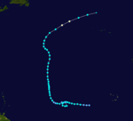
, Ivan
Hurricane Ivan
Hurricane Ivan was a large, long-lived, Cape Verde-type hurricane that caused widespread damage in the Caribbean and United States. The cyclone was the ninth named storm, the sixth hurricane and the fourth major hurricane of the active 2004 Atlantic hurricane season...
, and Jeanne
Hurricane Jeanne
Hurricane Jeanne was the deadliest hurricane in the 2004 Atlantic hurricane season. It was the tenth named storm, the seventh hurricane, and the fifth major hurricane of the season, as well as the third hurricane and fourth named storm of the season to make landfall in Florida...
. This is the only time in recorded history that four hurricanes affected the U.S. State
U.S. state
A U.S. state is any one of the 50 federated states of the United States of America that share sovereignty with the federal government. Because of this shared sovereignty, an American is a citizen both of the federal entity and of his or her state of domicile. Four states use the official title of...
of Florida
Florida
Florida is a state in the southeastern United States, located on the nation's Atlantic and Gulf coasts. It is bordered to the west by the Gulf of Mexico, to the north by Alabama and Georgia and to the east by the Atlantic Ocean. With a population of 18,801,310 as measured by the 2010 census, it...
although one of the four, Ivan, brought hurricane force winds to the state without making a landfall there.
June and July
June 1- The Atlantic hurricane season officially begins.
July 31
- 2 p.m. EDT (1800 UTCCoordinated Universal TimeCoordinated Universal Time is the primary time standard by which the world regulates clocks and time. It is one of several closely related successors to Greenwich Mean Time. Computer servers, online services and other entities that rely on having a universally accepted time use UTC for that purpose...
) – Tropical Depression One forms 200 miles (325 km)The figures for maximum sustained windMaximum sustained windThe maximum sustained winds associated with a tropical cyclone are a common indicator of the intensity of the storm. Within a mature tropical cyclone, they are found within the eyewall at a distance defined as the radius of maximum wind, or RMW. Unlike gusts, the value of these winds are...
s and position estimates are rounded to the nearest 5 units (knots, miles, or kilometersKilometreThe kilometre is a unit of length in the metric system, equal to one thousand metres and is therefore exactly equal to the distance travelled by light in free space in of a second...
), following the convention used in the National Hurricane CenterNational Hurricane CenterThe National Hurricane Center , located at Florida International University in Miami, Florida, is the division of the National Weather Service responsible for tracking and predicting weather systems within the tropics between the Prime Meridian and the 140th meridian west poleward to the 30th...
's operational products for each storm. All other units are rounded to the nearest digit. east of Jacksonville, FloridaJacksonville, FloridaJacksonville is the largest city in the U.S. state of Florida in terms of both population and land area, and the largest city by area in the contiguous United States. It is the county seat of Duval County, with which the city government consolidated in 1968...
.
August

- 2 p.m. EDT (1800 UTC) – Tropical Depression One strengthens into Tropical Storm Alex.
August 3
- 2 a.m. EDT (0600 UTC) – Tropical Storm Alex strengthens into Hurricane AlexHurricane Alex (2004)Hurricane Alex was the first named storm, the first hurricane, and the first major hurricane of the 2004 Atlantic hurricane season. The first storm of the season, Alex formed unusually late in the season; the fifth latest since 1954. It developed from the interaction between an upper-level low and...
. - 8 a.m. EDT (1200 UTC) – Hurricane Alex reaches Category 2 strength.
- 8 a.m. EDT (1200 UTC) – Tropical Depression Two forms near the Lesser AntillesLesser AntillesThe Lesser Antilles are a long, partly volcanic island arc in the Western Hemisphere. Most of its islands form the eastern boundary of the Caribbean Sea with the Atlantic Ocean, with the remainder located in the southern Caribbean just north of South America...
, 415 miles (665 km) east of the Lesser AntillesLesser AntillesThe Lesser Antilles are a long, partly volcanic island arc in the Western Hemisphere. Most of its islands form the eastern boundary of the Caribbean Sea with the Atlantic Ocean, with the remainder located in the southern Caribbean just north of South America...
. - 1 p.m. EDT (1700 UTC) – Hurricane Alex skirts the Outer BanksOuter BanksThe Outer Banks is a 200-mile long string of narrow barrier islands off the coast of North Carolina, beginning in the southeastern corner of Virginia Beach on the east coast of the United States....
of North CarolinaNorth CarolinaNorth Carolina is a state located in the southeastern United States. The state borders South Carolina and Georgia to the south, Tennessee to the west and Virginia to the north. North Carolina contains 100 counties. Its capital is Raleigh, and its largest city is Charlotte...
but does not make landfall.
August 4
- 2 p.m. EDT (1800 UTC) – Tropical Depression Two degenerates into a tropical wave in the eastern Caribbean SeaCaribbean SeaThe Caribbean Sea is a sea of the Atlantic Ocean located in the tropics of the Western hemisphere. It is bounded by Mexico and Central America to the west and southwest, to the north by the Greater Antilles, and to the east by the Lesser Antilles....
. - 8 p.m. EDT (0000 UTC, August 5) – Hurricane Alex reaches Category 3 strength. The storm is centered 445 miles (715 km) southwest of Halifax, Nova Scotia, the second furthest north a hurricane has reached this strength.
August 6
- 8 a.m. ASTUTC-4UTC−04-00 is an identifier for a time offset from UTC of −04.This offset is used in the Atlantic Standard Time Zone in Canada and the North American Eastern Time Zone during daylight saving time , in the Caribbean region this is considered as the Eastern Caribbean timezone...
(1200 UTC) – Hurricane Alex weakens into a tropical storm. - 7 a.m. CDT (1200 UTC) – Tropical Depression Two regenerates in the Yucatán ChannelYucatán ChannelThe Yucatán Channel is a strait between Mexico and Cuba. It connects the Yucatán Basin of the Caribbean Sea with the Gulf of Mexico. The strait is across between Cape Catoche in Mexico and Cape San Antonio, Cuba and reaches a maximum depth of .-References:...
. - 2 p.m. AST (1800 UTC) – Tropical Storm Alex becomes extratropicalExtratropical cycloneExtratropical cyclones, sometimes called mid-latitude cyclones or wave cyclones, are a group of cyclones defined as synoptic scale low pressure weather systems that occur in the middle latitudes of the Earth having neither tropical nor polar characteristics, and are connected with fronts and...
east of Newfoundland.
August 9
- 8 a.m. AST (1200 UTC) – Tropical Depression Three forms near the Windward IslandsWindward IslandsThe Windward Islands are the southern islands of the Lesser Antilles, within the West Indies.-Name and geography:The Windward Islands are called such because they were more windward to sailing ships arriving in the New World than the Leeward Islands, given that the prevailing trade winds in the...
, 115 miles (80 km) south-southeast of BarbadosBarbadosBarbados is an island country in the Lesser Antilles. It is in length and as much as in width, amounting to . It is situated in the western area of the North Atlantic and 100 kilometres east of the Windward Islands and the Caribbean Sea; therein, it is about east of the islands of Saint...
. - 7 a.m. CDT (1200 UTC) – Tropical Depression Two strengthens into Tropical Storm BonnieTropical Storm Bonnie (2004)Tropical Storm Bonnie was a small tropical storm that made landfall on Florida in August 2004. The second storm of the 2004 Atlantic hurricane season, Bonnie developed from a tropical wave on August 3 to the east of the Lesser Antilles. After moving through the islands, its fast forward motion...
in the southern Gulf of MexicoGulf of MexicoThe Gulf of Mexico is a partially landlocked ocean basin largely surrounded by the North American continent and the island of Cuba. It is bounded on the northeast, north and northwest by the Gulf Coast of the United States, on the southwest and south by Mexico, and on the southeast by Cuba. In...
.
August 10
- 2 a.m. AST (0600 UTC) – Tropical Depression Three strengthens into Tropical Storm Charley.
August 11
- 2 p.m. EDT (1800 UTC) – Tropical Storm Charley strengthens into Hurricane CharleyHurricane CharleyHurricane Charley was the third named storm, the second hurricane, and the second major hurricane of the 2004 Atlantic hurricane season. Charley lasted from August 9 to August 15, and at its peak intensity it attained 150 mph winds, making it a strong Category 4 hurricane on the...
. - 8 p.m. EDT (0000 UTC, August 12) – Hurricane Charley skirts the southern coast of JamaicaJamaicaJamaica is an island nation of the Greater Antilles, in length, up to in width and 10,990 square kilometres in area. It is situated in the Caribbean Sea, about south of Cuba, and west of Hispaniola, the island harbouring the nation-states Haiti and the Dominican Republic...
.
August 12
- 8 a.m. EDT (1200 UTC) – Hurricane Charley passes between Grand CaymanGrand CaymanGrand Cayman is the largest of the three Cayman Islands and the location of the nation's capital, George Town. In relation to the other two Cayman Islands, it is approximately 75 miles southwest of Little Cayman and 90 miles southwest of Cayman Brac.-Geography:Grand Cayman encompasses 76% of...
and Little CaymanLittle CaymanLittle Cayman is an island that is part of the Cayman Islands. It is located in the Caribbean Sea, about 75 miles northeast of Grand Cayman and five miles west of Cayman Brac. Little Cayman has a permanent population of less than 170 and is about 10 miles long with an average width of 1 mile...
. - 10 a.m. EDT (1400 UTC) – Tropical Storm Bonnie makes landfall near Apalachicola, FloridaApalachicola, FloridaApalachicola is a city in Franklin County, Florida, on US 98 about southwest of Tallahassee. The population was 2,334 at the 2000 census. The 2005 census estimated the city's population at 2,340...
with 45 mi/h winds. - 11 a.m. EDT (1500 UTC) – Hurricane Charley reaches Category 2 intensity.
- 2 p.m. EDT (1800 UTC) – Tropical Storm Bonnie weakens into a tropical depression.
August 13

- 12:30 a.m. EDT (0430 UTC) – Hurricane Charley makes its first landfall in CubaCubaThe Republic of Cuba is an island nation in the Caribbean. The nation of Cuba consists of the main island of Cuba, the Isla de la Juventud, and several archipelagos. Havana is the largest city in Cuba and the country's capital. Santiago de Cuba is the second largest city...
as a Category 3 storm with 120 mi/h winds, but weakening back down to Category 2 as it leaves the island just west of HavanaHavanaHavana is the capital city, province, major port, and leading commercial centre of Cuba. The city proper has a population of 2.1 million inhabitants, and it spans a total of — making it the largest city in the Caribbean region, and the most populous...
. - 8 a.m. AST (1200 UTC) – Tropical Depression Four forms 240 miles (390 km) south-southeast of Cape VerdeCape VerdeThe Republic of Cape Verde is an island country, spanning an archipelago of 10 islands located in the central Atlantic Ocean, 570 kilometres off the coast of Western Africa...
. - 10 a.m. EDT (1400 UTC) – Hurricane Charley reaches Category 3 intensity again.
- 1 p.m. EDT (1700 UTC) – Hurricane Charley reaches Category 4 intensity.
- 2 p.m. AST (1800 UTC) – Tropical Depression Five forms 1,150 miles (1,850 km) east of the Windward Islands.
- 3:45 p.m. EDT (1945 UTC) – Hurricane Charley makes its second landfall just West of Fort Myers, FloridaFort Myers, FloridaFort Myers is the county seat and commercial center of Lee County, Florida, United States. Its population was 62,298 in the 2010 census, a 29.23 percent increase over the 2000 figure....
with 150 mi/h winds. - 4:45 p.m. EDT (2045 UTC) – Hurricane Charley makes its third landfall at Punta Gorda, FloridaPunta Gorda, FloridaPunta Gorda is a city in Charlotte County, Florida, United States. According to the U.S. Census Bureau estimates of 2007, the city had a population of 16,762. It is the county seat of Charlotte County and the only incorporated municipality in the county...
with 145 mi/h winds. - 8 p.m. EDT (0000 UTC, August 14) – Tropical Depression Bonnie degenerates into a remnant low.
- 8 p.m. AST (0000 UTC, August 14) – Tropical Depression Four strengthens into Tropical Storm Danielle.
- 10:30 EDT (0130 UTC, August 14) – Hurricane Charley crosses central Florida, passing near OrlandoOrlando, FloridaOrlando is a city in the central region of the U.S. state of Florida. It is the county seat of Orange County, and the center of the Greater Orlando metropolitan area. According to the 2010 US Census, the city had a population of 238,300, making Orlando the 79th largest city in the United States...
. - 11:30 p.m. EDT (0330 UTC, August 14) – Hurricane Charley exits Florida near Daytona BeachDaytona Beach, FloridaDaytona Beach is a city in Volusia County, Florida, USA. According to 2008 U.S. Census Bureau estimates, the city has a population of 64,211. Daytona Beach is a principal city of the Deltona – Daytona Beach – Ormond Beach, Florida Metropolitan Statistical Area, which the census bureau estimated had...
.
August 14
- 10 a.m. EDT (1400 UTC) – Hurricane Charley makes a fourth landfall near Cape Romain, South CarolinaSouth CarolinaSouth Carolina is a state in the Deep South of the United States that borders Georgia to the south, North Carolina to the north, and the Atlantic Ocean to the east. Originally part of the Province of Carolina, the Province of South Carolina was one of the 13 colonies that declared independence...
with 80 mi/h winds and moves back offshore. - 12 p.m. EDT (1600 UTC) – Hurricane Charley makes a fifth landfall near North Myrtle Beach, South CarolinaNorth Myrtle Beach, South CarolinaNorth Myrtle Beach is a coastal resort city in Horry County, South Carolina, United States. It was created in 1968 from four existing municipalities north of Myrtle Beach, and serves as one of the primary tourist towns along the Grand Strand...
with 75 mi/h. - 2 p.m. EDT (1800 UTC) – Hurricane Charley weakens into a tropical storm.
- 2 p.m. AST (1800 UTC) – Tropical Depression Five strengthens into Tropical Storm EarlTropical Storm Earl (2004)Tropical Storm Earl was the fifth tropical storm of the 2004 Atlantic hurricane season. It was a short-lived storm in mid-August 2004 that formed near the Windward Islands and remained weak throughout its short lifespan. It crossed over the Lesser Antilles on August 14 while a modest tropical...
. - 8 p.m. EDT (0000 UTC, August 15) – Tropical Storm Charley becomes extratropical over South Carolina.
- 8 p.m. AST (0000 UTC, August 15) – Tropical Storm Danielle strengthens into Hurricane DanielleHurricane Danielle (2004)Hurricane Danielle was the first of several Cape Verde-type hurricane to form during the 2004 Atlantic hurricane season. Danielle was the fourth named storm and third hurricane of the season...
.
August 15
- 10 a.m. EDT (1400 UTC) – Tropical Storm Earl passes just south of GrenadaGrenadaGrenada is an island country and Commonwealth Realm consisting of the island of Grenada and six smaller islands at the southern end of the Grenadines in the southeastern Caribbean Sea...
and enters the Caribbean. - 2 p.m. AST (1800 UTC) – Hurricane Danielle reaches Category 2 intensity.
- 8 p.m. EDT (0000 UTC, August 16) – Tropical Storm Earl degenerates into a tropical wave.
August 18
- 8 a.m. AST (1200 UTC) – Hurricane Danielle weakens into a tropical storm.
August 20
- 2 p.m. AST (1800 UTC) – Tropical Storm Danielle weakens into a tropical depression.
August 21
- 2 p.m. AST (1800 UTC) – Danielle dissipates into a broad area of low-pressure.
August 24
- 8 p.m. EDT (0000 UTC, August 25) – Tropical Depression Six forms 750 miles (1,200 km) west-southwest of Cape Verde.
August 25
- 2 p.m. EDT (1800 UTC) – Tropical Depression Six strengthens into Tropical Storm Frances.
August 26
- 2 p.m. EDT (1800 UTC) – Tropical Storm Frances strengthens into Hurricane FrancesHurricane FrancesHurricane Frances was the sixth named storm, the fourth hurricane, and the third major hurricane of the 2004 Atlantic hurricane season. The system crossing the open Atlantic during mid to late August, moving to the north of the Lesser Antilles while strengthening. Its outer bands affected Puerto...
.
August 27
- 8 a.m. EDT (1200 UTC) – Hurricane Frances reaches Category 2 strength.
- 8 a.m. EDT (1200 UTC) – Tropical Depression Seven forms 130 miles (215 km) east-southeast of Charleston, South CarolinaCharleston, South CarolinaCharleston is the second largest city in the U.S. state of South Carolina. It was made the county seat of Charleston County in 1901 when Charleston County was founded. The city's original name was Charles Towne in 1670, and it moved to its present location from a location on the west bank of the...
. - 2 p.m. EDT (1800 UTC) – Hurricane Frances reaches Category 3 strength.
- 2 p.m. EDT (1800 UTC) – A tropical depression forms 230 miles (370 km) south of BermudaBermudaBermuda is a British overseas territory in the North Atlantic Ocean. Located off the east coast of the United States, its nearest landmass is Cape Hatteras, North Carolina, about to the west-northwest. It is about south of Halifax, Nova Scotia, Canada, and northeast of Miami, Florida...
.
August 28

- 2 a.m. EDT (0600 UTC) – Tropical Depression Seven strengthens into Tropical Storm Gaston.
- 2 p.m. EDT (1800 UTC) – Hurricane Frances reaches Category 4 strength.
August 29
- 8 a.m. EDT (1200 UTC) – Tropical Storm Gaston strengthens into Hurricane GastonHurricane Gaston (2004)Hurricane Gaston was a minimal hurricane that made landfall in South Carolina on August 29, 2004. It then crossed North Carolina and Virginia before exiting to the northeast and dissipating. The storm killed nine people — eight of them directly — and caused $130 million in damage....
. - 8 a.m. EDT (1200 UTC) – The tropical depression to the south of Bermuda strengthens into Tropical Storm HermineTropical Storm Hermine (2004)Tropical Storm Hermine was a moderate tropical storm that made landfall in southeastern Massachusetts. The eighth tropical cyclone and named storm of the 2004 Atlantic hurricane season, it formed from the same frontal zone over the western Atlantic that spawned Hurricane Gaston. Hermine remained...
. - 10 a.m. EDT (1400 UTC) – Hurricane Gaston makes landfall near Awendaw, South CarolinaAwendaw, South CarolinaAwendaw is a small fishing town in Charleston County, South Carolina, United States. The population was 1,195 at the 2000 census. As defined by the U.S. Office of Management and Budget, and used by the U.S...
with 75 mi/h winds. - 8 p.m. EDT (0000 UTC, August 30) – Tropical Storm Gaston weakens into a tropical depression.
August 30
- 8 p.m. EDT (0000 UTC, August 31) – Tropical Depression Gaston re-strengthens into a tropical storm.
August 31
- 2 a.m. EDT (0600 UTC) – Tropical Storm Hermine makes landfall near New Bedford, MassachusettsNew Bedford, MassachusettsNew Bedford is a city in Bristol County, Massachusetts, United States, located south of Boston, southeast of Providence, Rhode Island, and about east of Fall River. As of the 2010 census, the city had a total population of 95,072, making it the sixth-largest city in Massachusetts...
with 40 mi/h winds. - 8 a.m. EDT (1200 UTC) – Tropical Storm Hermine becomes extratropical.
September
September 1- 8 a.m. EDT (1200 UTC) – Tropical Storm Gaston becomes extratropical.
September 2
- 2 p.m. EDT (1800 UTC) – Tropical Depression Nine forms about 550 miles (900 km) south-west of Cape Verde.
- 3:30 p.m. EDT (1930 UTC) – Hurricane Frances strikes San Salvador IslandSan Salvador IslandSan Salvador Island, also known as Watlings Island, is an island and district of the Bahamas. Until 1986, when the National Geographic Society suggested Samana Cay, it was widely believed that during his first expedition to the New World, San Salvador Island was the first land sighted and visited...
with 125 mi/h winds.
September 3
- 1:30 a.m. EDT (0530 UTC) – Hurricane Frances strikes Cat IslandCat Island (Bahamas)Cat Island is in the central Bahamas, and one of its districts, and has the nation's highest point. Its Mount Alvernia rises to 206 ft and is topped by a monastery called The Hermitage. This assembly of buildings was erected by the Franciscan "Brother Jerome" .The first European settlers were...
with 115 mi/h winds. - 2 a.m. EDT (0600 UTC) – Tropical Depression Nine strengthens into Tropical Storm Ivan.
- 6 a.m. EDT (1000 UTC) – Hurricane Frances strikes EleutheraEleutheraEleuthera is an island in The Bahamas, lying 50 miles east of Nassau. It is very long and thin—110 miles long and in places little more than a mile wide. According to the 2000 Census, the population of Eleuthera is approximately 8,000...
with 110 mi/h winds.
September 4
- 6 a.m. EDT (1000 UTC) – Hurricane Frances strikes Grand BahamaGrand BahamaGrand Bahama is one of the northernmost of the islands of the Bahamas, and the closest major island to the United States, lying off the state of Florida. Grand Bahama is the fifth largest island in the Bahamas island chain of approximately 700 islands and 2,400 cays...
with 105 mi/h winds.
September 5
- 12:30 a.m. EDT (0430 UTC) – Hurricane Frances makes landfall on the east coast of Florida with 105 mi/h winds.
- 2 a.m. EDT (0600 UTC) – Tropical Storm Ivan strengthens into Hurricane IvanHurricane IvanHurricane Ivan was a large, long-lived, Cape Verde-type hurricane that caused widespread damage in the Caribbean and United States. The cyclone was the ninth named storm, the sixth hurricane and the fourth major hurricane of the active 2004 Atlantic hurricane season...
. - 8 a.m. EDT (1200 UTC) – Hurricane Ivan reaches Category 2 strength.
- 2 p.m. EDT (1800 UTC) – Hurricane Ivan reaches Category 3 strength.
- 2 p.m. EDT (1800 UTC) – Hurricane Frances weakens into a tropical storm.
- 8 p.m. EDT (0000 UTC, September 6) – Hurricane Ivan reaches Category 4 strength.
- approximately 11 p.m. EDT (0300 UTC, September 6) – Tropical Storm Frances emerges over the Gulf of Mexico.
September 6
- 2 p.m. EDT (1800 UTC) – Tropical Storm Frances makes its second landfall near St. Marks, FloridaSt. Marks, FloridaSt. Marks is a city in Wakulla County, Florida, United States. It is part of the Tallahassee, Florida, Metropolitan Statistical Area. The population was 272 at the 2000 census. As of 2004, the population estimated by the U.S. Census Bureau is 299 .-Geography:...
with 60 mi/h winds.
September 7
- 2 a.m. EDT (0600 UTC) – Tropical Storm Frances weakens into a tropical depression.
- 5 a.m. AST (0900 UTC) – Tropical Depression Ten forms 725 miles (1150 km) west-southwest of the Azores.
- 5:30 p.m. EDT (2130 UTC) – Hurricane Ivan passes just south of GrenadaGrenadaGrenada is an island country and Commonwealth Realm consisting of the island of Grenada and six smaller islands at the southern end of the Grenadines in the southeastern Caribbean Sea...
with 125 mi/h winds.
September 9
- 2 a.m. AST (0600 UTC) – Hurricane Ivan reaches Category 5 strength less than 100 miles (160 km) away from ArubaArubaAruba is a 33 km-long island of the Lesser Antilles in the southern Caribbean Sea, located 27 km north of the coast of Venezuela and 130 km east of Guajira Peninsula...
. - 8 a.m. AST (1200 UTC) – Tropical Depression Ten degenerates into a remnant low.
September 10

- 11:30 p.m. EDT (0330 UTC, September 11 – Hurricane Ivan passes just south of JamaicaJamaicaJamaica is an island nation of the Greater Antilles, in length, up to in width and 10,990 square kilometres in area. It is situated in the Caribbean Sea, about south of Cuba, and west of Hispaniola, the island harbouring the nation-states Haiti and the Dominican Republic...
with 150 mi/h winds.
September 11
- 8 p.m. EDT (0000 UTC, September 12) – Hurricane Ivan has a recorded minimum pressure of 910 millibars, making it the then sixth most intense Atlantic hurricane on record.
September 12
- 10:45 a.m. EDT (1415 UTC) – Hurricane Ivan passes close to Grand CaymanGrand CaymanGrand Cayman is the largest of the three Cayman Islands and the location of the nation's capital, George Town. In relation to the other two Cayman Islands, it is approximately 75 miles southwest of Little Cayman and 90 miles southwest of Cayman Brac.-Geography:Grand Cayman encompasses 76% of...
with 150 mi/h winds.
September 13
- 2 p.m. AST (1800 UTC) – Tropical Depression Eleven forms 70 miles (110 km) east-southeast of GuadeloupeGuadeloupeGuadeloupe is an archipelago located in the Leeward Islands, in the Lesser Antilles, with a land area of 1,628 square kilometres and a population of 400,000. It is the first overseas region of France, consisting of a single overseas department. As with the other overseas departments, Guadeloupe...
. - 9 p.m. EDT (0100 UTC, September 14) – Hurricane Ivan passes near the western tip of CubaCubaThe Republic of Cuba is an island nation in the Caribbean. The nation of Cuba consists of the main island of Cuba, the Isla de la Juventud, and several archipelagos. Havana is the largest city in Cuba and the country's capital. Santiago de Cuba is the second largest city...
with 160 mi/h winds.
September 14
- 12 a.m. AST (0400 UTC) – Tropical Depression Eleven makes landfall on GuadeloupeGuadeloupeGuadeloupe is an archipelago located in the Leeward Islands, in the Lesser Antilles, with a land area of 1,628 square kilometres and a population of 400,000. It is the first overseas region of France, consisting of a single overseas department. As with the other overseas departments, Guadeloupe...
with 35 mi/h winds. - 8 a.m. AST (1200 UTC) – Tropical Depression Eleven strengthens into Tropical Storm Jeanne.
September 15
- 12 p.m. EDT (1600 UTC) – Tropical Storm Jeanne makes landfall near Yabucoa, Puerto RicoYabucoa, Puerto RicoYabucoa is a small town in the south eastern tip of Puerto Rico located in the southeastern region, north of Maunabo; south of San Lorenzo, Las Piedras and Humacao; and east of Patillas and about one hour from San Juan. Yabucoa is spread over 9 wards and Yabucoa Pueblo...
with 60 mi/h winds.
September 16
- 2 a.m. AST (0600 UTC) – Tropical Depression Twelve forms 390 miles (630 km) southwest of the Cape VerdeCape VerdeThe Republic of Cape Verde is an island country, spanning an archipelago of 10 islands located in the central Atlantic Ocean, 570 kilometres off the coast of Western Africa...
islands. - 1:50 a.m. CDT (0650 UTC) – Hurricane Ivan makes landfall near Gulf Shores, AlabamaGulf Shores, Alabama-External links:*...
with 120 mi/h winds. - 7 a.m. AST (1100 UTC) – Tropical Storm Jeanne strengthens into Hurricane JeanneHurricane JeanneHurricane Jeanne was the deadliest hurricane in the 2004 Atlantic hurricane season. It was the tenth named storm, the seventh hurricane, and the fifth major hurricane of the season, as well as the third hurricane and fourth named storm of the season to make landfall in Florida...
as it makes landfall on the Dominican RepublicDominican RepublicThe Dominican Republic is a nation on the island of La Hispaniola, part of the Greater Antilles archipelago in the Caribbean region. The western third of the island is occupied by the nation of Haiti, making Hispaniola one of two Caribbean islands that are shared by two countries...
with 80 mi/h winds. - 1 p.m. CDT (1800 UTC) – Hurricane Ivan weakens into a tropical storm.
- 2 p.m. AST (1800 UTC) – Tropical Depression Twelve strengthens into Tropical Storm Karl.
- 7 p.m. CDT (0000 UTC, September 17) – Tropical Storm Ivan weakens into a tropical depression
- 8 p.m. AST (0000 UTC, September 17) – Hurricane Jeanne weakens into a tropical storm as it interacts with HispaniolaHispaniolaHispaniola is a major island in the Caribbean, containing the two sovereign states of the Dominican Republic and Haiti. The island is located between the islands of Cuba to the west and Puerto Rico to the east, within the hurricane belt...
.
September 17
- 2 p.m. AST (1800 UTC) – Tropical Storm Jeanne weakens into a tropical depression.
- 8 p.m. AST (0000 UTC, September 18) – Tropical Depression Jeanne re-strengthens to Tropical Storm Jeanne.
- 8 p.m. EDT (0000 UTC, September 18) – Tropical Storm Karl strengthens into Hurricane KarlHurricane Karl (2004)Hurricane Karl was a powerful Cape Verde-type hurricane during the 2004 Atlantic hurricane season. It was the eleventh named storm, eighth hurricane and sixth major hurricane of the 2004 season. Karl formed on September 16, originating from a strong tropical wave that emerged off of Africa. It...
.
September 18
- 2 a.m. EDT (0600 UTC) – Hurricane Karl reaches Category 2 strength.
- 2 p.m. EDT (1800 UTC) – Tropical Depression Ivan becomes extratropical while crossing VirginiaVirginiaThe Commonwealth of Virginia , is a U.S. state on the Atlantic Coast of the Southern United States. Virginia is nicknamed the "Old Dominion" and sometimes the "Mother of Presidents" after the eight U.S. presidents born there...
. Some remnants travel north, others loop back south.
September 19
- 2 a.m. EDT (0600 UTC) – Hurricane Karl reaches Category 3 strength.
- 2 p.m. EDT (1800 UTC) – Tropical Depression Thirteen forms 520 miles (830 km) west-southwest of the Cape VerdeCape VerdeThe Republic of Cape Verde is an island country, spanning an archipelago of 10 islands located in the central Atlantic Ocean, 570 kilometres off the coast of Western Africa...
islands.
September 20
- 2 a.m. EDT (0600 UTC) – Hurricane Karl reaches Category 4 strength.
- 8 a.m. AST (1200 UTC) – Tropical Depression Thirteen strengthens into Tropical Storm Lisa.
- 2 p.m. AST (1800 UTC) – Tropical Storm Jeanne strengthens back into Hurricane Jeanne.
September 22
- 2 a.m. AST (0600 UTC) – Hurricane Jeanne reaches Category 2 strength.
- 1 p.m. CDT (1800 UTC) – A partial remnant of former Hurricane Ivan regenerates into Tropical Depression Ivan in the Gulf of Mexico.
- 7 p.m. CDT (0000 UTC, September 23) – Tropical Depression Ivan strengthens into Tropical Storm Ivan, nearly a week after being classified as extratropical.
September 23
- 2 p.m. AST (1800 UTC) – Tropical Storm Lisa weakens into a tropical depression.
- 7 p.m. CDT (0000 UTC, September 24) – Tropical Storm Ivan weakens into a tropical depression.
- 9 p.m. CDT (0200 UTC, September 24) – Tropical Depression Ivan makes its second landfall near Cameron, LouisianaCameron, LouisianaCameron is a census-designated place in and the parish seat of Cameron Parish, Louisiana, United States. The population was 1,965 at the 2000 census. It is part of the Lake Charles Metropolitan Statistical Area...
with 30 mi/h winds.
September 24
- 2 a.m. AST (0600 UTC) – Tropical Depression Lisa regains tropical storm strength.
- 7 a.m. CDT (1200 UTC) – Tropical Depression Ivan dissipates over Texas.
- 2 p.m. AST (1800 UTC) – Tropical Storm Lisa weakens into a tropical depression again.
- 8 p.m. EDT (0000 UTC, September 25) – Hurricane Karl becomes extratropical, but remains a strong storm heading north.
September 25
- 2 a.m. AST (0600 UTC) – Tropical Depression Lisa becomes Tropical Storm Lisa for the third time.
- 8 a.m. AST (1200 UTC) – Hurricane Jeanne reaches Category 3 strength while it makes its third landfall on AbacoAbaco IslandsThe Abaco Islands lie in the northern Bahamas and comprise the main islands of Great Abaco and Little Abaco, together with the smaller Wood Cay, Elbow Cay, Lubbers Quarters Cay, Green Turtle Cay, Great Guana Cay, Castaway Cay, Man-o-War Cay, Stranger's Cay, Umbrella Cay, Walker's Cay, Little Grand...
with 115 mi/h winds. - 2 p.m. AST (1800 UTC) – Hurricane Jeanne passes near Grand BahamaGrand BahamaGrand Bahama is one of the northernmost of the islands of the Bahamas, and the closest major island to the United States, lying off the state of Florida. Grand Bahama is the fifth largest island in the Bahamas island chain of approximately 700 islands and 2,400 cays...
with 120 mi/h winds.
September 26
- 12 a.m. EDT (0400 UTC) – Hurricane Jeanne makes landfall near Stuart, FloridaStuart, FloridaStuart is the only incorporated city of Martin County, Florida, on Florida's Treasure Coast. The population was 14,633 at the 2000 census. As of 2007, the population recorded by the U.S. Census Bureau is 15,964....
with 120 mi/h winds. - 2 p.m. EDT (1800 UTC) – Hurricane Jeanne weakens into a tropical storm.
September 27
- 2 p.m. EDT (1800 UTC) – Tropical Storm Jeanne weakens into a tropical depression.
September 28
- 8 p.m. EDT (0000 UTC, September 29) – Tropical Depression Jeanne becomes extratropical.
October
- 2 a.m. AST (0600 UTC) – Tropical Storm Lisa strengthens into Hurricane LisaHurricane Lisa (2004)Hurricane Lisa was a long-lived Cape Verde-type hurricane in the 2004 Atlantic hurricane season. It was the twelfth named storm, as well as the ninth and final hurricane of the season. Lisa formed on September 19 and spent nearly two weeks fluctuating between a tropical depression and a tropical...
. - 2 p.m. AST (1800 UTC) – Hurricane Lisa weakens into a tropical storm.
October 3
- 2 a.m. AST (0600 UTC) – Tropical Storm Lisa becomes extratropical.
October 8
- 7 a.m. CDT (1200 UTC) – Tropical Depression Fourteen forms 210 miles (330 km) southeast of Brownsville, TexasBrownsville, TexasBrownsville is a city in the southernmost tip of the state of Texas, in the United States. It is located on the northern bank of the Rio Grande, directly north and across the border from Matamoros, Tamaulipas, Mexico. Brownsville is the 16th largest city in the state of Texas with a population of...
. - 1 p.m. CDT (1800 UTC) – Tropical Depression Fourteen strengthens into Tropical Storm MatthewTropical Storm Matthew (2004)Tropical Storm Matthew was a weak tropical storm in the 2004 Atlantic hurricane season that made landfall on Louisiana. Matthew was the thirteenth tropical storm of the season and the ninth storm to affect the United States. Matthew formed over the western Gulf of Mexico on October 8 and struck...
.
October 10
- 2 a.m. AST (0600 UTC) – A low-pressure system 140 miles (220 km) southwest of Bermuda becomes Subtropical Storm NicoleSubtropical Storm Nicole (2004)Subtropical Storm Nicole was the first subtropical storm to receive a name using the standard hurricane name list that did not become a tropical cyclone. The fourteenth tropical or subtropical storm of the 2004 Atlantic hurricane season, Nicole developed on October 10 near Bermuda from the...
. - 6 a.m. CDT (1100 UTC) – Tropical Storm Matthew makes landfall on the LouisianaLouisianaLouisiana is a state located in the southern region of the United States of America. Its capital is Baton Rouge and largest city is New Orleans. Louisiana is the only state in the U.S. with political subdivisions termed parishes, which are local governments equivalent to counties...
coast south of HoumaHouma, LouisianaHouma is a city in and the parish seat of Terrebonne Parish, Louisiana, and the largest principal city of the Houma–Bayou Cane–Thibodaux Metropolitan Statistical Area. The city's powers of government have been absorbed by the parish, which is now run by the Terrebonne Parish...
with 40 mi/h winds. - 7 a.m. CDT (1200 UTC) – Tropical Storm Matthew weakens into a tropical depression.
- 7 p.m. CDT (0000 UTC, October 11) – Tropical Depression Matthew becomes extratropical.
- 8 p.m. AST (0000 UTC, October 12) – Subtropical Storm Nicole is absorbed by a larger non-tropical cyclone.
November
November 29- 7 a.m. EST (1200 UTC) – Subtropical Storm Otto forms 1,150 miles (1,850 km) east-southeast of BermudaBermudaBermuda is a British overseas territory in the North Atlantic Ocean. Located off the east coast of the United States, its nearest landmass is Cape Hatteras, North Carolina, about to the west-northwest. It is about south of Halifax, Nova Scotia, Canada, and northeast of Miami, Florida...
from a non-tropical low.
November 30
- 7 a.m. EST (1200 UTC) – Subtropical Storm Otto gains tropical characteristics and becomes Tropical Storm Otto.
- The Atlantic hurricane season officially ends.
December
December 2- 7 a.m. EST (1200 UTC) – Tropical Storm Otto weakens into a tropical depression.
December 3
- 1 a.m. EST (0600 UTC) – Tropical Depression Otto dissipates into a remnant low, the last storm of the season.
See also
- 2004 Atlantic hurricane season2004 Atlantic hurricane seasonThe 2004 Atlantic hurricane season officially began on June 1, 2004, and lasted until November 30, 2004. These dates conventionally delimit the period of each year when most tropical cyclones form in the Atlantic basin...
- List of Atlantic hurricane seasons
- Timeline of the 2004 Pacific hurricane seasonTimeline of the 2004 Pacific hurricane seasonThe 2004 Pacific hurricane season had 17 tropical cyclones, of which 12 became named storms, 6 became hurricanes, and 3 became major hurricanes . This timeline documents all the storm formations, strengthening, weakening, landfalls, extratropical transitions, as well as dissipation...
- 2004 Pacific typhoon season2004 Pacific typhoon seasonThe 2004 Pacific typhoon season has no official bounds; it ran year-round in 2004, but most tropical cyclones tend to form in the northwestern Pacific Ocean between May and November...