

Timeline of the 2004 Pacific hurricane season
Encyclopedia
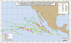
2004 Pacific hurricane season
The 2004 Pacific hurricane season officially started on May 15, 2004 in the eastern Pacific, and on June 1, 2004 in the central Pacific, and lasted until November 30, 2004...
had 17 tropical cyclone
Tropical cyclone
A tropical cyclone is a storm system characterized by a large low-pressure center and numerous thunderstorms that produce strong winds and heavy rain. Tropical cyclones strengthen when water evaporated from the ocean is released as the saturated air rises, resulting in condensation of water vapor...
s, of which 12 became named storms, 6 became hurricanes, and 3 became major hurricanes (Category 3 or higher). This timeline documents all the storm formations, strengthening, weakening, landfalls
Landfall (meteorology)
Landfall is the event of a tropical cyclone or a waterspout coming onto land after being over water. When a waterspout makes landfall it is reclassified as a tornado, which can then cause damage inland...
, extratropical transitions, as well as dissipation. It also includes information which was not operationally released, meaning that information from post-storm reviews by the National Hurricane Center
National Hurricane Center
The National Hurricane Center , located at Florida International University in Miami, Florida, is the division of the National Weather Service responsible for tracking and predicting weather systems within the tropics between the Prime Meridian and the 140th meridian west poleward to the 30th...
, such as information on a storm that was not operationally warned on, have been included. The season officially began on May 15, 2004 in the eastern Pacific proper (June 1, 2004 in the central Pacific) and lasted until November 30 that same year. Areas east of 140°W
Longitude
Longitude is a geographic coordinate that specifies the east-west position of a point on the Earth's surface. It is an angular measurement, usually expressed in degrees, minutes and seconds, and denoted by the Greek letter lambda ....
are under the purview of the National Hurricane Center (NHC); the area between the International Date Line
International Date Line
The International Date Line is a generally north-south imaginary line on the surface of the Earth, passing through the middle of the Pacific Ocean, that designates the place where each calendar day begins...
and 140°W, or the central Pacific, is under the purview of the Central Pacific Hurricane Center
Central Pacific Hurricane Center
The Central Pacific Hurricane Center of the United States National Weather Service is the official body responsible for tracking and issuing tropical cyclone warnings, watches, advisories, discussions, and statements for the Central North Pacific Basin...
(CPHC).
The 2004 season got off to an early start with Tropical Storm Agatha, which formed a week after the season began. No tropical cyclones were active in June, the first such occurrence since 1969
1969 Pacific hurricane season
The 1969 Pacific hurricane season was an event in meteorology. It officially started on May 15, 1969 in the eastern Pacific and lasted until November 30, 1969. However, the first named storm, Ava, did not form until July 1, the latest date that the first named storm of a season formed...
. July was more active, producing four tropical cyclones. Three of these (Blas, Celia, and Darby
Hurricane Darby (2004)
Hurricane Darby was the first Eastern Pacific major hurricane since Hurricane Kenna in 2002. The sixth tropical cyclone, fourth named storm, and second hurricane of the 2004 Pacific hurricane season, Darby developed from a tropical wave that emerged from the west coast of Africa on July 12. After...
) became named storms, two (Celia and Darby) became hurricanes, and Hurricane Darby became the first major hurricane of the season. Additionally, a tropical depression in the central Pacific became the only tropical cyclone to form within the Central Pacific Hurricane Center's area of responsibility during the year. August was the most active month, producing six tropical cyclones, four named storms, and two hurricanes (Frank and Howard
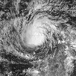
Hurricane Howard (2004)
Hurricane Howard was a powerful Category 4 hurricane which produced large swells along the coasts of Baja California and southern California. The eighth named storm of the 2004 Pacific hurricane season, Howard originated out of a tropical wave off the coast of Mexico on August 30...
). September saw a decline in activity, although all three storms that existed during the month were hurricanes, two of which (Howard and Javier
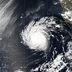
Hurricane Javier (2004)
Hurricane Javier was the tenth named storm and the sixth and final hurricane of the 2004 Pacific hurricane season. Javier was also the strongest hurricane of the 2004 season, with 150 mph winds and a central pressure of 930 millibars...
) were major hurricanes. Hurricane Howard, which had formed in August, only became a major hurricane in September. Hurricane Javier – the final storm during the month – was the strongest storm of the season. October saw the final three tropical cyclones of the year; two developed into named storms (Kay and Lester
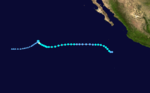
Tropical Storm Lester (2004)
Tropical Storm Lester was a weak tropical storm that paralleled the Mexican coastline in October 2004. The 16th tropical cyclone and 12th named storm of the 2004 Pacific hurricane season, Lester originated from an area of disturbed weather that persisted southwest of the Gulf of Tehuantepec. After...
). Neither of these storms became hurricanes.
May
- The 2004 Pacific hurricane season officially begins.
May 21
- 5:00 p.m. PDTPacific Time ZoneThe Pacific Time Zone observes standard time by subtracting eight hours from Coordinated Universal Time . The clock time in this zone is based on the mean solar time of the 120th meridian west of the Greenwich Observatory. During daylight saving time, its time offset is UTC-7.In the United States...
(00:00 UTCCoordinated Universal TimeCoordinated Universal Time is the primary time standard by which the world regulates clocks and time. It is one of several closely related successors to Greenwich Mean Time. Computer servers, online services and other entities that rely on having a universally accepted time use UTC for that purpose...
May 22) – Tropical Depression One-E forms about 580 miles (933.4 km) to the southeast of Cabo San Lucas, Mexico.
May 22
- 5:00 a.m. PDT (12:00 UTC) – Tropical Depression One-E strengthens into a tropical storm and is named Agatha.
- 5:00 p.m. PDT (00:00 UTC May 22) – Tropical Storm Agatha reaches its peak intensity of 60 mph (95 km/h).
May 23
- 5:00 p.m. PDT (00:00 UTC May 22) – Tropical Storm Agatha weakens into a tropical depression.
May 24
- 5:00 a.m. PDT (12:00 UTC) – Tropical Depression Agatha degenerates into an area of low pressure.
June
- There was no tropical cyclone activity in the Eastern Pacific during June. The last time this happened was in 1969.
June 1
- The 2004 Central Pacific hurricane season officially begins.
July
July 2- 5:00 a.m. PDT (12:00 UTC) – Tropical Depression Two-E forms about 750 miles (1,207 km) to the southwest of the southern tip of the Baja California peninsula of MexicoBaja California PeninsulaThe Baja California peninsula , is a peninsula in northwestern Mexico. Its land mass separates the Pacific Ocean from the Gulf of California. The Peninsula extends from Mexicali, Baja California in the north to Cabo San Lucas, Baja California Sur in the south.The total area of the Baja California...
. - 5:00 p.m. PDT (00:00 UTC July 3) – Tropical Depression Two-E reaches its peak intensity of abbr=on 35.
July 3
- 5:00 p.m. PDT (00:00 UTC July 4) – Tropical Depression Two-E degenerates into an area of low pressure.
July 4
- 2:00 p.m. HSTHawaii-Aleutian time zoneThe Hawaii-Aleutian Time Zone observes Hawaii-Aleutian Standard Time , by subtracting ten hours from Coordinated Universal Time . The clock time in this zone is based on the mean solar time of the 150th meridian west of the Greenwich Observatory....
(00:00 UTC July 5) – Tropical Depression One-C forms about 700 miles (1,126.5 km) to the south-southeast of Johnston Island. - 2:00 p.m. HST (00:00 UTC July 5) – Tropical Depression One-C reaches its peak intensity of abbr=on 30.
July 5
- 2:00 p.m. HST (00:00 UTC July 6) – Tropical Depression One-C dissipates.
July 12
- 5:00 a.m. PDT (12:00 UTC) – Tropical Depression Three-E forms 320 miles (515 km) south-southwest of Manzanillo, MexicoManzanillo, ColimaThe name Manzanillo refers to the city as well as its surrounding municipality in the Mexican state of Colima. The city, located on the Pacific Ocean, contains Mexico's busiest port. Manzanillo was the third port created by the Spanish in the Pacific during the New Spain period...
.The distance between the location of Tropical Storm Blas's formation and Manzanillo, Mexico, was calculated using the National Oceanic and Atmospheric AdministrationNational Oceanic and Atmospheric AdministrationThe National Oceanic and Atmospheric Administration , pronounced , like "noah", is a scientific agency within the United States Department of Commerce focused on the conditions of the oceans and the atmosphere...
's Latitude/Longitude Distance Calculator; in the Tropical Cyclone Report for Blas, its location at formation is given as 14.6°NLatitudeIn geography, the latitude of a location on the Earth is the angular distance of that location south or north of the Equator. The latitude is an angle, and is usually measured in degrees . The equator has a latitude of 0°, the North pole has a latitude of 90° north , and the South pole has a...
, 105.5°W. - 11:00 a.m. PDT (18:00 UTC) – Tropical Depression Three-E strengthens into a tropical storm and is named Blas.
July 13
- 5:00 a.m. PDT (12:00 UTC) – Tropical Storm Blas reaches its peak intensity of abbr=on 65.
July 14
- 11:00 a.m. PDT (18:00 UTC) – Tropical Storm Blas weakens into a tropical depression.
- 11:00 p.m. PDT (06:00 UTC July 15) – Tropical Depression Blas degenerates into an area of low pressure.
July 18
- 5:00 p.m. PDT (00:00 UTC July 19) – Tropical Depression Four-E forms about 620 miles (997.8 km) south-southwest of the southern tip of Baja California.
July 19
- 5:00 a.m. PDT (12:00 UTC) – Tropical Depression Four-E strengthens into a tropical storm and is named Celia.
July 21
- 5:00 p.m. PDT (00:00 UTC July 22) – Tropical Storm Celia strengthens into the first hurricane of the season.
- 11:00 p.m. PDT (06:00 UTC July 22) – Hurricane Celia reaches its peak intensity of abbr=on 85.
July 22
- 11:00 a.m. PDT (18:00 UTC) – Hurricane Celia weakens into a tropical storm.
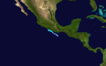
July 24
- 11:00 a.m. PDT (18:00 UTC) – Tropical Storm Celia weakens into a tropical depression.
.jpg)
- 5:00 p.m. PDT (00:00 UTC July 22) – Tropical Depression Celia degenerates into an area of low pressure.
July 26
- 5:00 a.m. PDT (12:00 UTC) – Tropical Depression Five-E forms about 760 miles (1,223.1 km) south-southwest of Cabo San Lucas.
- 5:00 p.m. PDT (00:00 UTC July 27) – Tropical Depression Five-E is upgraded to Tropical Storm Darby.
July 27
- 5:00 p.m. PDT (00:00 UTC July 28) – Tropical Storm Darby strengthens into a Category 1 hurricane.
July 28
- 11:00 a.m. PDT (18:00 UTC) – Hurricane Darby reaches Category 2 intensity.
- 11:00 p.m. PDT (06:00 UTC July 29) – Hurricane Darby reaches Category 3 intensity and becomes the first Pacific major hurricane since Hurricane KennaHurricane KennaHurricane Kenna was the second-most intense Pacific hurricane to strike the west coast of Mexico in recorded history. Kenna was the sixteenth tropical depression, thirteenth tropical storm, seventh hurricane, sixth major hurricane, and third Category 5 hurricane of the 2002 Pacific hurricane season...
in 20022002 Pacific hurricane seasonThe 2002 Pacific hurricane season was an event in tropical cyclone meteorology. The most notable storm that year was Hurricane Kenna, which reached Category 5 on the Saffir-Simpson Hurricane Scale. It made landfall near Puerto Vallarta, in the Mexican state of Jalisco, on October 25...
. - 11:00 p.m. PDT (06:00 UTC July 29) – Hurricane Darby reaches its peak intensity of abbr=on 120.
July 29
- 11:00 a.m. PDT (18:00 UTC) – Hurricane Darby weakens to Category 2 intensity.
- 5:00 p.m. PDT (00:00 UTC July 28) – Hurricane Darby weakens to Category 1 intensity.
July 30
- 5:00 a.m. PDT (12:00 UTC) – Hurricane Darby weakens into a tropical storm.
July 31
- 5:00 a.m. PDT (12:00 UTC) – Tropical Storm Darby weakens into a tropical depression.
- 5:00 p.m. PDT (2:00 p.m. HST 00:00 UTC August 1) – The NHC passes the primary warning responsibility of Tropical Depression Darby to the CPHC as Darby crosses 140°W.
- 11:00 p.m. PDT (06:00 UTC August 1) – Tropical Depression Six-E forms.
- 11:00 p.m. PDT (06:00 UTC August 1) – Tropical Depression Six-E reaches its peak intensity of abbr=on 30.
August
August 1- 2:00 a.m. HST (12:00 UTC) – Tropical Depression Darby dissipates.
- 11:00 p.m. PDT (06:00 UTC August 2) – Tropical Depression Six-E dissipates.
August 18
- 11:00 p.m. PDT (06:00 UTC August 19) – Tropical Depression Seven-E forms about 1440 miles (2,317.4 km) to the southeast of Hilo, Hawaii.
August 19
- 11:00 p.m. PDT (06:00 UTC August 20) – Tropical Depression Seven-E intensifies into a tropical storm and is named Estelle.
August 20
- 11:00 p.m. PDT (8:00 p.m. HST; 06:00 UTC August 21) – The NHC passes primary warning responsibility of Tropical Storm Estelle to the CPHC as Estelle crosses 140°W.
August 21
- 2:00 a.m. HST (12:00 UTC) – Tropical Storm Estelle reaches its peak intensity of 70 mph (110 km/h).
August 22
- 2:00 p.m. HST (00:00 UTC August 23) – Tropical Storm Estelle weakens into a tropical depression.
- 11:00 p.m. PDT (06:00 UTC August 23) – Tropical Depression Eight-E forms from the remains of Tropical Storm EarlTropical Storm Earl (2004)Tropical Storm Earl was the fifth tropical storm of the 2004 Atlantic hurricane season. It was a short-lived storm in mid-August 2004 that formed near the Windward Islands and remained weak throughout its short lifespan. It crossed over the Lesser Antilles on August 14 while a modest tropical...
, which crossed over from the Atlantic basinAtlantic OceanThe Atlantic Ocean is the second-largest of the world's oceanic divisions. With a total area of about , it covers approximately 20% of the Earth's surface and about 26% of its water surface area...
. At this time, it is located about 410 miles (659.8 km) south of Cabo San Lucas.
August 23
- 5:00 a.m. PDT (12:00 UTC) – Tropical Depression Eight-E becomes a tropical storm and is named Frank.
- 11:00 a.m. PDT (18:00 UTC) – Tropical Storm Frank strengthens into a Category 1 hurricane.
- 11:00 a.m. PDT (18:00 UTC) – Tropical Depression Nine-E forms about 920 miles (1,480.6 km) west-southwest of the tip of Baja California.
- 5:00 p.m. PDT (00:00 UTC August 24) – Tropical Depression Nine-E reaches its peak intensity of 35 mph (55 km/h).
- 11:00 p.m. PDT (06:00 UTC August 24) – Hurricane Frank reaches its peak intensity of abbr=on 85.
August 24
- 8:00 a.m. HST (18:00 UTC) – Tropical Depression Estelle degenerates into a remnant low.
- 11:00 p.m. PDT (06:00 UTC August 25) – Hurricane Frank weakens into a tropical storm.
August 25
- 5:00 p.m. PDT (00:00 UTC August 26) – Tropical Storm Frank weakens into a tropical depression.
- 11:00 p.m. PDT (06:00 UTC August 26) – Tropical Depression Frank degenerates into a remnant low.
August 26
- 5:00 a.m. PDT (12:00 UTC) – Tropical Depression Ten-E forms about 605 miles (973.7 km) south-southeast of the southern tip of Baja California.
- 11:00 a.m. PDT (18:00 UTC) – Tropical Depression Nine-E degenerates into a remnant low.
- 11:00 a.m. PDT (18:00 UTC) – Tropical Depression Ten-E strengthens into a tropical storm and is named Georgette.
August 27
- 5:00 a.m. PDT (12:00 UTC) – Tropical Storm Georgette reaches its peak intensity of 65 mph (100 km/h).
August 29
- 11:00 p.m. PDT (06:00 UTC August 30) – Tropical Storm Georgette weakens into a tropical depression.
August 30

- 5:00 a.m. PDT (12:00 UTC) – Tropical Depression Eleven-E forms about 400 miles (643.7 km) to the southwest of AcapulcoAcapulcoAcapulco is a city, municipality and major sea port in the state of Guerrero on the Pacific coast of Mexico, southwest from Mexico City. Acapulco is located on a deep, semi-circular bay and has been a port since the early colonial period of Mexico’s history...
, Mexico. - 11:00 a.m. PDT (18:00 UTC) – Tropical Depression Georgette degenerates into a remnant low.
- 5:00 p.m. PDT (00:00 UTC August 31) – Tropical Depression Eleven-E intensifies into a tropical storm and is named Howard.
August 31
- 11:00 p.m. PDT (06:00 UTC September 1) – Tropical Storm Howard strengthens into a Category 1 hurricane.
September
September 1- 11:00 p.m. PDT (06:00 UTC September 2) – Hurricane Howard rapidly intensifies and reaches Category 3 intensity.
September 2
- 5:00 a.m. PDT (12:00 UTC) – Hurricane Howard reaches Category 4 intensity. At the same time, it reaches its peak intensity of 140 mph (230 km/h).
- 11:00 p.m. PDT (06:00 UTC September 3) – Hurricane Howard weakens into Category 3 intensity.
September 3
- 5:00 a.m. PDT (12:00 UTC) – Hurricane Howard weakens to Category 2 intensity.
- 11:00 a.m. PDT (18:00 UTC) – Hurricane Howard weakens to Category 1 intensity.
September 4
- 5:00 a.m. PDT (12:00 UTC) – Hurricane Howard weakens into a tropical storm.
- 11:00 p.m. PDT (06:00 UTC September 5) – Tropical Storm Howard weakens into a tropical depression.
September 5
- 11:00 a.m. PDT (18:00 UTC) – Tropical Depression Howard degenerates into a remnant low.
September 7
- 11:00 p.m. PDT (06:00 UTC September 8) – Tropical Depression Twelve-E forms about 530 miles (853 km) south of Cabo San Lucas.
September 8
- 11:00 a.m. PDT (18:00 UTC) – Tropical Depression Twelve-E becomes a tropical storm and is named Isis.
September 10
- 5:00 a.m. PDT (12:00 UTC) – Tropical Storm Isis weakens into a tropical depression.
- 11:00 a.m. PDT (18:00 UTC) – Tropical Depression Thirteen-E forms about 350 miles (563.3 km) south-southeast of Salina CruzSalina CruzSalina Cruz is a major seaport on the Pacific coast of the Mexican state of Oaxaca. It is the state's third-largest city and is municipal seat of the municipality of the same name.It is part of the Tehuantepec District in the west of the Istmo Region....
, Mexico.
September 11
- 5:00 a.m. PDT (12:00 UTC) – Tropical Depression Thirteen-E becomes a tropical storm and is named Javier.
- 5:00 p.m. PDT (00:00 UTC September 12) – Tropical Depression Isis restrengthens into a tropical storm.
September 12
- 11:00 a.m. PDT (18:00 UTC) – Tropical Storm Javier strengthens into a Category 1 hurricane.
- 11:00 p.m. PDT (06:00 UTC September 13) – Hurricane Javier reaches Category 2 intensity.
September 13

- 5:00 a.m. PDT (12:00 UTC) – Hurricane Javier reaches Category 3 intensity.
- 11:00 a.m. PDT (18:00 UTC) – Hurricane Javier reaches Category 4 intensity.
- 5:00 p.m. PDT (00:00 UTC September 14) – Hurricane Javier reaches its peak intensity of 150 mph (240 km/h), making it the strongest storm of the season. At this time, it is located 310 miles (498.9 km) south-southwest of Manzanillo, Mexico.
September 15
- 5:00 a.m. PDT (12:00 UTC) – Tropical Storm Isis strengthens into a Category 1 hurricane. At the same time, it reaches its peak intensity of 75 mph (120.7 km/h), located 1450 miles (2,333.5 km) west of Cabo San Lucas.
- 11:00 a.m. PDT (18:00 UTC) – Hurricane Isis weakens back into a tropical storm as the eye collapses.
- 5:00 p.m. PDT (00:00 UTC September 16) – Hurricane Javier weakens to Category 3 intensity.
September 16
- 5:00 a.m. PDT (12:00 UTC) – Tropical Storm Isis weakens into a tropical depression.
- 11:00 a.m. PDT (18:00 UTC) – Tropical Depression Isis degenerates into a remnant low.
September 17
- 5:00 a.m. PDT (12:00 UTC) – Hurricane Javier weakens to Category 2 intensity.
- 5:00 p.m. PDT (00:00 UTC September 18) – Hurricane Javier weakens to Category 1 intensity.
September 18
- 5:00 a.m. PDT (12:00 UTC) – Hurricane Javier weakens into a tropical storm.
- 5:00 p.m. PDT (00:00 UTC September 19) – Tropical Storm Javier weakens into a tropical depression.
September 19
- 4:00 a.m. PDT (11:00 UTC) – Tropical Depression Javier makes landfallLandfall (meteorology)Landfall is the event of a tropical cyclone or a waterspout coming onto land after being over water. When a waterspout makes landfall it is reclassified as a tornado, which can then cause damage inland...
on the west coast of Baja California. - 11:00 a.m. PDT (18:00 UTC) – Tropical Depression Javier degenerates into a remnant low.
October
October 4- 11:00 a.m. PDT (18:00 UTC) – Tropical Depression Fourteen-E forms about 595 miles (957.6 km) to the southwest of Manzanillo, Mexico.
- 11:00 p.m. PDT (06:00 UTC October 5) – Tropical Depression Fourteen-E strengthens into a tropical storm and is named Kay.
October 5
- 5:00 a.m. PDT (12:00 UTC) – Tropical Storm Kay reaches its peak intensity of abbr=on 45.
- 11:00 a.m. PDT (18:00 UTC) – Tropical Storm Kay weakens into a tropical depression.
October 6
- 5:00 a.m. PDT (12:00 UTC) – Tropical Depression Kay weakens into a remnant low.
October 11
- 11:00 a.m. PDT (18:00 UTC) – Tropical Depression Fifteen-E forms about 90 miles (144.8 km) south of Puerto Escondido, Mexico.
October 12
- 11:00 a.m. PDT (18:00 UTC) – Tropical Depression Fifteen-E strengthens into a tropical storm and is named Lester.
- 5:00 p.m. PDT (00:00 UTC October 13) – Tropical Storm Lester reaches its peak intensity of abbr=on 50.
October 13
- 5:00 a.m. PDT (12:00 UTC) – Tropical Storm Lester weakens into a tropical depression.
- 11:00 a.m. PDT (18:00 UTC) – Tropical Depression Lester dissipates.
October 24
- 5:00 p.m. PDT (00:00 UTC October 25) – Tropical Depression Sixteen-E forms about 315 miles (506.9 km) south-southeast of the southern tip of Baja California.
- 11:00 p.m. PDT (06:00 UTC October 25) – Tropical Depression Sixteen-E reaches its peak intensity of abbr=on 35.
October 26
- 3:00 a.m. PDT (10:00 UTC) – Tropical Depression Sixteen-E makes landfall on Sinaloa state in Mexico.
- 11:00 a.m. PDT (18:00 UTC) – Tropical Depression Sixteen-E dissipates over land.
November
- There was no tropical cyclone activity during November in the Eastern Pacific.
November 30
- The 2004 Pacific hurricane season officially ends.
See also
- Timeline of the 2004 Atlantic hurricane seasonTimeline of the 2004 Atlantic hurricane seasonThe 2004 Atlantic hurricane season was notable as one of the deadliest and most costly Atlantic hurricane seasons on record. It officially began on June 1, 2004 and ended on November 30, although storm activity continued into December. This timeline documents tropical cyclone formations,...
- Timeline of the 2004 Pacific typhoon season
- Timelines of the South Pacific cyclone seasons: 2003–04Timeline of the 2003–04 South Pacific cyclone seasonThe 2003–04 South Pacific cyclone season was a below-average season with only three tropical cyclones occurring within the South Pacific to the east of 160°E...
, 2004–05