

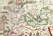
Catalan Atlas
Encyclopedia
Catalonia
Catalonia is an autonomous community in northeastern Spain, with the official status of a "nationality" of Spain. Catalonia comprises four provinces: Barcelona, Girona, Lleida, and Tarragona. Its capital and largest city is Barcelona. Catalonia covers an area of 32,114 km² and has an...
map of the medieval period. It was produced by the Majorcan cartographic school
Majorcan cartographic school
The Majorcan cartographic school is the term coined by historians to refer to the collection of cartographers, cosmographers and navigational instrument-makers that flourished in Majorca in the 14th and 15th Centuries. The label is usually inclusive of those who worked in mainland Catalonia...
and is attributed to Cresques Abraham (also known as "Abraham Cresques"), a Jewish book illuminator
Illuminated manuscript
An illuminated manuscript is a manuscript in which the text is supplemented by the addition of decoration, such as decorated initials, borders and miniature illustrations...
who was self-described as being a master of the maps of the world as well as compasses. It has been in the royal library of France (now the Bibliothèque nationale de France
Bibliothèque nationale de France
The is the National Library of France, located in Paris. It is intended to be the repository of all that is published in France. The current president of the library is Bruno Racine.-History:...
) since the time of Charles V
Charles V of France
Charles V , called the Wise, was King of France from 1364 to his death in 1380 and a member of the House of Valois...
. The Catalan Atlas originally consisted of 6 vellum leaves folded down the middle, painted in various colors including gold and silver. The leaves are now cut in half. Each half-leaf is mounted on one side of five wooden panels. The first half of the first leaf and the second half of the last leaf are mounted on the inner boards of a brown leather binding. Each measures approximately 65 × 50 cm. The overall size is therefore 65 × 300 cm.
The first two leaves contain texts in Catalan language
Catalan language
Catalan is a Romance language, the national and only official language of Andorra and a co-official language in the Spanish autonomous communities of Catalonia, the Balearic Islands and Valencian Community, where it is known as Valencian , as well as in the city of Alghero, on the Italian island...
covering cosmography
Cosmography
Cosmography is the science that maps the general features of the universe, describing both heaven and Earth...
, astronomy
Astronomy
Astronomy is a natural science that deals with the study of celestial objects and phenomena that originate outside the atmosphere of Earth...
, and astrology
Astrology
Astrology consists of a number of belief systems which hold that there is a relationship between astronomical phenomena and events in the human world...
. These texts are accompanied by illustrations. The texts and illustration emphasize the Earth's spherical shape and the state of the known world. They also provide information to sailors on tides and how to tell time at night.
The four remaining leaves make up the actual map, which is divided into two principal parts. The map shows illustrations of many cities, whose political allegiances are symbolized by a flag. Christian cities are marked with a cross, other cities with a dome. Wavy blue vertical lines are used to symbolize oceans. Place names of important ports are transcribed in red, while others are indicated in black.
Unlike many other nautical charts, the Catalan Atlas is read with the north at the bottom. As a result of this the maps are oriented from left to right, from the Far East to the Atlantic.
The first two leaves, forming the oriental portion of the Catalan Atlas, illustrate numerous religious references as well as a synthesis of medieval mappae mundi (Jerusalem located close to the centre) and the travel literature of the time, notably Marco Polo
Marco Polo
Marco Polo was a Venetian merchant traveler from the Venetian Republic whose travels are recorded in Il Milione, a book which did much to introduce Europeans to Central Asia and China. He learned about trading whilst his father and uncle, Niccolò and Maffeo, travelled through Asia and apparently...
's Book of Marvels and the Travels and Voyage of Sir John Mandeville. Many Indian and Chinese cities can be identified. The explanatory texts report customs described by Marco Polo
Marco Polo
Marco Polo was a Venetian merchant traveler from the Venetian Republic whose travels are recorded in Il Milione, a book which did much to introduce Europeans to Central Asia and China. He learned about trading whilst his father and uncle, Niccolò and Maffeo, travelled through Asia and apparently...
and catalogue local economic resources, real or supposed.
External links
- Bibliothèque nationale de France - L'Atlas Catalan ; The Catalan Atlas [via archive.org]
- www.cresquesproject.net --Translation in English of the works of Riera i Sans and Gabriel Llompart on the Jewish Majorcan Map-makers of the High Middle Ages
- details of Catalan Atlas (close up) from Contemporary Balears.