
Synoptic scale meteorology
Encyclopedia
The synoptic scale in meteorology
(also known as large scale or cyclonic scale) is a horizontal length scale of the order of 1000 kilometres (about 620 miles) or more. This corresponds to a horizontal scale typical of mid-latitude depressions (e.g. extratropical cyclone
s). Most high and low-pressure areas seen on weather map
s such as surface weather analyses
are synoptic-scale systems, driven by the location of Rossby wave
s in their respective hemisphere. Low-pressure areas and their related frontal zones occur on the leading edge of a trough within the Rossby wave pattern, while surface highs form on the back edge of the trough. Most precipitation
areas occur near frontal zones. The word synoptic is derived from the Greek word (), meaning seen together.
The Navier–Stokes equations applied to atmospheric motion can be simplified by scale analysis
in the synoptic scale. It can be shown that the main terms in horizontal equations are Coriolis force
and pressure gradient
terms; therefore, one can use geostrophic approximation
. In vertical coordinates, the momentum equation simplifies to the hydrostatic equilibrium
equation.
 Rossby waves in the atmosphere
are easy to observe as (usually 4-6) large-scale meanders of the jet stream
across the Northern or Southern Hemispheres. When these loops become very pronounced, they detach the masses of cold, or warm, air that become cyclone
s and anticyclone
s and are responsible for day-to-day weather patterns at mid-latitudes.
The wave speed is given by

where c is the wave speed, u is the mean westerly flow, is the Rossby parameter
, and k is the total wavenumber.
Furthermore, the Rossby parameter
is defined:
φ is the latitude, ω is the angular speed of the Earth's rotation, and a is the mean radius of the Earth.
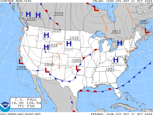
A surface weather analysis
is a special type of weather map
that provides a view of weather
elements over a geographical area at a specified time based on information from ground-based weather stations. Weather maps are created by plotting or tracing the values of relevant quantities such as sea level pressure, temperature
, and cloud cover
onto a geographical map to help find synoptic scale features such as weather fronts.
The first weather maps in the 19th century were drawn well after the fact to help devise a theory on storm systems. After the advent of the telegraph, simultaneous surface weather observation
s became possible for the first time, and beginning in the late 1840s, the Smithsonian Institution
became the first organization to draw real-time surface analyses. Use of surface analyses began first in the United States, spreading worldwide during the 1870s. Use of the Norwegian cyclone model
for frontal analysis began in the late 1910s across Europe, with its use finally spreading to the United States during World War II
.
Surface weather analyses have special symbols which show frontal systems, cloud cover, precipitation
, or other important information. For example, an H represents high pressure
, implying good and fair weather. An L represents low pressure, which frequently accompanies precipitation. Various symbols are used not just for frontal zones and other surface boundaries on weather maps, but also to depict the present weather at various locations on the weather map. Areas of precipitation help determine the frontal type and location. Mesoscale systems and boundaries such as tropical cyclone
s, outflow boundaries and squall line
s also are analyzed on surface weather analyses. Isobars are commonly used to place surface boundaries from the horse latitudes
poleward, while streamline analyses are used in the tropics.
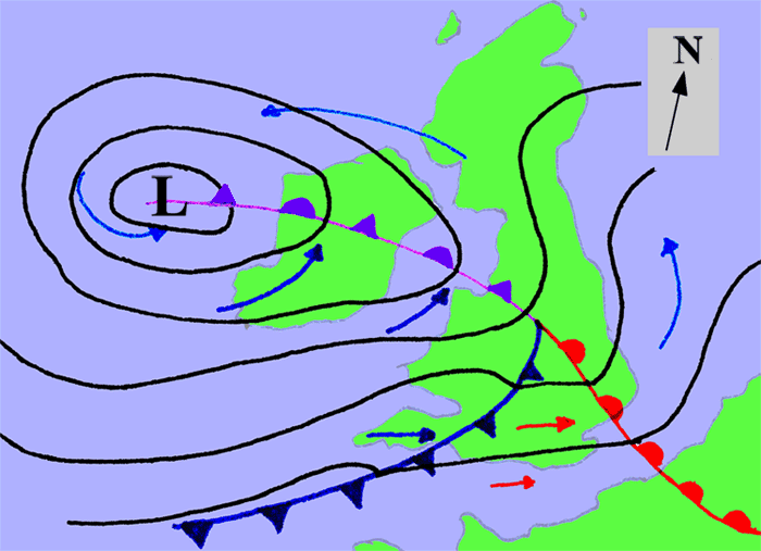
An extratropical cyclone is a synoptic scale low pressure
weather system that has neither tropical
nor polar
characteristics, being connected with fronts
and horizontal gradients in temperature
and dew point
otherwise known as "baroclinic zones".
The descriptor "extratropical" refers to the fact that this type of cyclone generally occurs outside of the tropics, in the middle latitudes of the planet. These systems may also be described as "mid-latitude cyclones" due to their area of formation, or "post-tropical cyclones" where extratropical transition has occurred, and are often described as "depressions" or "lows" by weather forecasters and the general public. These are the everyday phenomena which along with anti-cyclones, drive the weather over much of the Earth.
Although extratropical cyclones are almost always classified as baroclinic since they form along zones of temperature and dewpoint gradient within the westerlies
, they can sometimes become barotropic
late in their life cycle when the temperature distribution around the cyclone becomes fairly uniform with radius. An extratropical cyclone can transform into a subtropical storm, and from there into a tropical cyclone, if it dwells over warm waters and develops central convection, which warms its core.
 High pressure systems are frequently associated with light winds at the surface and subsidence
through the lower portion of the troposphere
. Subsidence will generally dry out an air mass by adiabatic
, or compressional, heating. Thus, high pressure typically brings clear skies. During the day, since no clouds are present to reflect sunlight, there is more incoming shortwave solar radiation and temperatures rise. At night, the absence of clouds means that outgoing longwave radiation (i.e. heat energy from the surface) is not absorbed, giving cooler diurnal
low temperatures in all seasons. When surface winds become light, the subsidence produced directly under a high-pressure system can lead to a build up of particulates in urban areas under the ridge, leading to widespread haze
. If the low level relative humidity
rises towards 100 percent overnight, fog
can form.
Strong, vertically shallow high-pressure systems moving from higher latitudes to lower latitudes in the northern hemisphere are associated with continental arctic air masses. The low, sharp inversion
can lead to areas of persistent stratocumulus or stratus cloud
, colloquially known as anticyclonic gloom. The type of weather brought about by an anticyclone depends on its origin. For example, extensions of the Azores high pressure may bring about anticyclonic gloom during the winter, as they are warmed at the base and will trap moisture as they move over the warmer oceans. High pressures that build to the north and extend southwards will often bring clear weather. This is due to being cooled at the base (as opposed to warmed) which helps prevent clouds from forming.
On weather maps, these areas show converging winds (isotachs), also known as confluence
, or converging height lines near or above the level of non-divergence, which is near the 500 hPa pressure surface about midway up through the troposphere. High-pressure systems are alternatively referred to as anticyclones. On weather maps, high-pressure centers are associated with the letter H in English, or A in Spanish, because alta is the Spanish word for high, within the isobar with the highest pressure value. On constant pressure upper level charts, it is located within the highest height line contour.
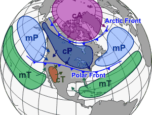 A weather front
is a boundary separating two masses of air
of different densities
, and is the principal cause of meteorological phenomena
. In surface weather analyses
, fronts are depicted using various colored lines and symbols, depending on the type of front. The air masses separated by a front usually differ in temperature
and humidity
.
Cold fronts may feature narrow bands of thunderstorm
s and severe weather
, and may on occasion be preceded by squall line
s or dry line
s. Warm front
s are usually preceded by stratiform precipitation
and fog
. The weather usually clears quickly after a front's passage. Some fronts produce no precipitation and little cloudiness, although there is invariably a wind shift.
Cold fronts and occluded front
s generally move from west to east, while warm fronts move poleward
. Because of the greater density of air in their wake, cold fronts and cold occlusions move faster than warm fronts and warm occlusions. Mountain
s and warm bodies of water can slow the movement of fronts. When a front becomes stationary
, and the density contrast across the frontal boundary vanishes, the front can degenerate into a line which separates regions of differing wind velocity, known as a shearline. This is most common over the open ocean.
Meteorology
Meteorology is the interdisciplinary scientific study of the atmosphere. Studies in the field stretch back millennia, though significant progress in meteorology did not occur until the 18th century. The 19th century saw breakthroughs occur after observing networks developed across several countries...
(also known as large scale or cyclonic scale) is a horizontal length scale of the order of 1000 kilometres (about 620 miles) or more. This corresponds to a horizontal scale typical of mid-latitude depressions (e.g. extratropical cyclone
Extratropical cyclone
Extratropical cyclones, sometimes called mid-latitude cyclones or wave cyclones, are a group of cyclones defined as synoptic scale low pressure weather systems that occur in the middle latitudes of the Earth having neither tropical nor polar characteristics, and are connected with fronts and...
s). Most high and low-pressure areas seen on weather map
Weather map
A weather map displays various meteorological features across a particular area at a particular point in time. Such maps have been in use since the mid-19th century and are used for research and weather forecasting purposes. Maps using isotherms show temperature gradients, which can help locate...
s such as surface weather analyses
Surface weather analysis
Surface weather analysis is a special type of weather map that provides a view of weather elements over a geographical area at a specified time based on information from ground-based weather stations...
are synoptic-scale systems, driven by the location of Rossby wave
Rossby wave
Atmospheric Rossby waves are giant meanders in high-altitude winds that are a major influence on weather.They are not to be confused with oceanic Rossby waves, which move along the thermocline: that is, the boundary between the warm upper layer of the ocean and the cold deeper part of the...
s in their respective hemisphere. Low-pressure areas and their related frontal zones occur on the leading edge of a trough within the Rossby wave pattern, while surface highs form on the back edge of the trough. Most precipitation
Precipitation (meteorology)
In meteorology, precipitation In meteorology, precipitation In meteorology, precipitation (also known as one of the classes of hydrometeors, which are atmospheric water phenomena is any product of the condensation of atmospheric water vapor that falls under gravity. The main forms of precipitation...
areas occur near frontal zones. The word synoptic is derived from the Greek word (), meaning seen together.
The Navier–Stokes equations applied to atmospheric motion can be simplified by scale analysis
Scale analysis (mathematics)
Scale analysis is a powerful tool used in the mathematical sciences for the simplification of equations with many terms. First the approximate magnitude of individual terms in the equations is determined...
in the synoptic scale. It can be shown that the main terms in horizontal equations are Coriolis force
Coriolis effect
In physics, the Coriolis effect is a deflection of moving objects when they are viewed in a rotating reference frame. In a reference frame with clockwise rotation, the deflection is to the left of the motion of the object; in one with counter-clockwise rotation, the deflection is to the right...
and pressure gradient
Pressure gradient
In atmospheric sciences , the pressure gradient is a physical quantity that describes in which direction and at what rate the pressure changes the most rapidly around a particular location. The pressure gradient is a dimensional quantity expressed in units of pressure per unit length...
terms; therefore, one can use geostrophic approximation
Geostrophic wind
The geostrophic wind is the theoretical wind that would result from an exact balance between the Coriolis effect and the pressure gradient force. This condition is called geostrophic balance. The geostrophic wind is directed parallel to isobars . This balance seldom holds exactly in nature...
. In vertical coordinates, the momentum equation simplifies to the hydrostatic equilibrium
Hydrostatic equilibrium
Hydrostatic equilibrium or hydrostatic balance is the condition in fluid mechanics where a volume of a fluid is at rest or at constant velocity. This occurs when compression due to gravity is balanced by a pressure gradient force...
equation.
Atmospheric Rossby waves

Atmosphere
An atmosphere is a layer of gases that may surround a material body of sufficient mass, and that is held in place by the gravity of the body. An atmosphere may be retained for a longer duration, if the gravity is high and the atmosphere's temperature is low...
are easy to observe as (usually 4-6) large-scale meanders of the jet stream
Jet stream
Jet streams are fast flowing, narrow air currents found in the atmospheres of some planets, including Earth. The main jet streams are located near the tropopause, the transition between the troposphere and the stratosphere . The major jet streams on Earth are westerly winds...
across the Northern or Southern Hemispheres. When these loops become very pronounced, they detach the masses of cold, or warm, air that become cyclone
Cyclone
In meteorology, a cyclone is an area of closed, circular fluid motion rotating in the same direction as the Earth. This is usually characterized by inward spiraling winds that rotate anticlockwise in the Northern Hemisphere and clockwise in the Southern Hemisphere of the Earth. Most large-scale...
s and anticyclone
Anticyclone
An anticyclone is a weather phenomenon defined by the United States' National Weather Service's glossary as "[a] large-scale circulation of winds around a central region of high atmospheric pressure, clockwise in the Northern Hemisphere, counterclockwise in the Southern Hemisphere"...
s and are responsible for day-to-day weather patterns at mid-latitudes.
The wave speed is given by

where c is the wave speed, u is the mean westerly flow,
 is the Rossby parameter
Rossby parameter
The Rossby parameter is a number used in geophysics and meteorology which arises due to the meridional variation of the Coriolis force caused by the spherical shape of the Earth...
, and k is the total wavenumber.
Furthermore, the Rossby parameter
Rossby parameter
The Rossby parameter is a number used in geophysics and meteorology which arises due to the meridional variation of the Coriolis force caused by the spherical shape of the Earth...
is defined:

φ is the latitude, ω is the angular speed of the Earth's rotation, and a is the mean radius of the Earth.
Surface weather analysis

A surface weather analysis
Surface weather analysis
Surface weather analysis is a special type of weather map that provides a view of weather elements over a geographical area at a specified time based on information from ground-based weather stations...
is a special type of weather map
Weather map
A weather map displays various meteorological features across a particular area at a particular point in time. Such maps have been in use since the mid-19th century and are used for research and weather forecasting purposes. Maps using isotherms show temperature gradients, which can help locate...
that provides a view of weather
Weather
Weather is the state of the atmosphere, to the degree that it is hot or cold, wet or dry, calm or stormy, clear or cloudy. Most weather phenomena occur in the troposphere, just below the stratosphere. Weather refers, generally, to day-to-day temperature and precipitation activity, whereas climate...
elements over a geographical area at a specified time based on information from ground-based weather stations. Weather maps are created by plotting or tracing the values of relevant quantities such as sea level pressure, temperature
Temperature
Temperature is a physical property of matter that quantitatively expresses the common notions of hot and cold. Objects of low temperature are cold, while various degrees of higher temperatures are referred to as warm or hot...
, and cloud cover
Cloud cover
Cloud cover refers to the fraction of the sky obscured by clouds when observed from a particular location...
onto a geographical map to help find synoptic scale features such as weather fronts.
The first weather maps in the 19th century were drawn well after the fact to help devise a theory on storm systems. After the advent of the telegraph, simultaneous surface weather observation
Surface weather observation
Surface weather observations are the fundamental data used for safety as well as climatological reasons to forecast weather and issue warnings worldwide. They can be taken manually, by a weather observer, by computer through the use of automated weather stations, or in a hybrid scheme using...
s became possible for the first time, and beginning in the late 1840s, the Smithsonian Institution
Smithsonian Institution
The Smithsonian Institution is an educational and research institute and associated museum complex, administered and funded by the government of the United States and by funds from its endowment, contributions, and profits from its retail operations, concessions, licensing activities, and magazines...
became the first organization to draw real-time surface analyses. Use of surface analyses began first in the United States, spreading worldwide during the 1870s. Use of the Norwegian cyclone model
Norwegian cyclone model
The older of the models of extratropical cyclone development is known as the Norwegian Cyclone Model, developed during and shortly after World War I within the Bergen School of Meteorology. In this theory, cyclones develop as they move up and along a frontal boundary, eventually occluding and...
for frontal analysis began in the late 1910s across Europe, with its use finally spreading to the United States during World War II
World War II
World War II, or the Second World War , was a global conflict lasting from 1939 to 1945, involving most of the world's nations—including all of the great powers—eventually forming two opposing military alliances: the Allies and the Axis...
.
Surface weather analyses have special symbols which show frontal systems, cloud cover, precipitation
Precipitation (meteorology)
In meteorology, precipitation In meteorology, precipitation In meteorology, precipitation (also known as one of the classes of hydrometeors, which are atmospheric water phenomena is any product of the condensation of atmospheric water vapor that falls under gravity. The main forms of precipitation...
, or other important information. For example, an H represents high pressure
High pressure area
A high-pressure area is a region where the atmospheric pressure at the surface of the planet is greater than its surrounding environment. Winds within high-pressure areas flow outward due to the higher density air near their center and friction with land...
, implying good and fair weather. An L represents low pressure, which frequently accompanies precipitation. Various symbols are used not just for frontal zones and other surface boundaries on weather maps, but also to depict the present weather at various locations on the weather map. Areas of precipitation help determine the frontal type and location. Mesoscale systems and boundaries such as tropical cyclone
Tropical cyclone
A tropical cyclone is a storm system characterized by a large low-pressure center and numerous thunderstorms that produce strong winds and heavy rain. Tropical cyclones strengthen when water evaporated from the ocean is released as the saturated air rises, resulting in condensation of water vapor...
s, outflow boundaries and squall line
Squall line
A squall line is a line of severe thunderstorms that can form along or ahead of a cold front. In the early 20th century, the term was used as a synonym for cold front. It contains heavy precipitation, hail, frequent lightning, strong straight-line winds, and possibly tornadoes and waterspouts....
s also are analyzed on surface weather analyses. Isobars are commonly used to place surface boundaries from the horse latitudes
Horse latitudes
Horse Latitudes or Subtropical High are subtropical latitudes between 30 and 35 degrees both north and south. This region, under a ridge of high pressure called the subtropical high, is an area which receives little precipitation and has variable winds mixed with calm.The consistently warm, dry...
poleward, while streamline analyses are used in the tropics.
Extratropical cyclone

An extratropical cyclone is a synoptic scale low pressure
Low pressure area
A low-pressure area, or "low", is a region where the atmospheric pressure at sea level is below that of surrounding locations. Low-pressure systems form under areas of wind divergence which occur in upper levels of the troposphere. The formation process of a low-pressure area is known as...
weather system that has neither tropical
Tropical cyclone
A tropical cyclone is a storm system characterized by a large low-pressure center and numerous thunderstorms that produce strong winds and heavy rain. Tropical cyclones strengthen when water evaporated from the ocean is released as the saturated air rises, resulting in condensation of water vapor...
nor polar
Polar cyclone
Polar cyclones are low-pressure areas which strengthen in the winter and weaken in the summer...
characteristics, being connected with fronts
Surface weather analysis
Surface weather analysis is a special type of weather map that provides a view of weather elements over a geographical area at a specified time based on information from ground-based weather stations...
and horizontal gradients in temperature
Temperature
Temperature is a physical property of matter that quantitatively expresses the common notions of hot and cold. Objects of low temperature are cold, while various degrees of higher temperatures are referred to as warm or hot...
and dew point
Dew point
The dew point is the temperature to which a given parcel of humid air must be cooled, at constant barometric pressure, for water vapor to condense into liquid water. The condensed water is called dew when it forms on a solid surface. The dew point is a saturation temperature.The dew point is...
otherwise known as "baroclinic zones".
The descriptor "extratropical" refers to the fact that this type of cyclone generally occurs outside of the tropics, in the middle latitudes of the planet. These systems may also be described as "mid-latitude cyclones" due to their area of formation, or "post-tropical cyclones" where extratropical transition has occurred, and are often described as "depressions" or "lows" by weather forecasters and the general public. These are the everyday phenomena which along with anti-cyclones, drive the weather over much of the Earth.
Although extratropical cyclones are almost always classified as baroclinic since they form along zones of temperature and dewpoint gradient within the westerlies
Westerlies
The Westerlies, anti-trades, or Prevailing Westerlies, are the prevailing winds in the middle latitudes between 30 and 60 degrees latitude, blowing from the high pressure area in the horse latitudes towards the poles. These prevailing winds blow from the west to the east, and steer extratropical...
, they can sometimes become barotropic
Barotropic
In meteorology, a barotropic atmosphere is one in which the pressure depends only on the density and vice versa, so that isobaric surfaces are also isopycnic surfaces . The isobaric surfaces will also be isothermal surfaces, hence the geostrophic wind is independent of height...
late in their life cycle when the temperature distribution around the cyclone becomes fairly uniform with radius. An extratropical cyclone can transform into a subtropical storm, and from there into a tropical cyclone, if it dwells over warm waters and develops central convection, which warms its core.
Surface high pressure systems

Subsidence (atmosphere)
Subsidence in the Earth's atmosphere is most commonly caused by low temperatures: as air cools, it becomes denser and moves towards the ground, just as warm air becomes less dense and moves upwards...
through the lower portion of the troposphere
Troposphere
The troposphere is the lowest portion of Earth's atmosphere. It contains approximately 80% of the atmosphere's mass and 99% of its water vapor and aerosols....
. Subsidence will generally dry out an air mass by adiabatic
Adiabatic process
In thermodynamics, an adiabatic process or an isocaloric process is a thermodynamic process in which the net heat transfer to or from the working fluid is zero. Such a process can occur if the container of the system has thermally-insulated walls or the process happens in an extremely short time,...
, or compressional, heating. Thus, high pressure typically brings clear skies. During the day, since no clouds are present to reflect sunlight, there is more incoming shortwave solar radiation and temperatures rise. At night, the absence of clouds means that outgoing longwave radiation (i.e. heat energy from the surface) is not absorbed, giving cooler diurnal
Diurnal temperature variation
Diurnal temperature variation is a meteorological term that relates to the variation in temperature that occurs from the highs of the day to the cool of nights.-Temperature lag:Temperature lag is an important factor in diurnal temperature variation...
low temperatures in all seasons. When surface winds become light, the subsidence produced directly under a high-pressure system can lead to a build up of particulates in urban areas under the ridge, leading to widespread haze
Haze
Haze is traditionally an atmospheric phenomenon where dust, smoke and other dry particles obscure the clarity of the sky. The World Meteorological Organization manual of codes includes a classification of horizontal obscuration into categories of fog, ice fog, steam fog, mist, haze, smoke, volcanic...
. If the low level relative humidity
Relative humidity
Relative humidity is a term used to describe the amount of water vapor in a mixture of air and water vapor. It is defined as the partial pressure of water vapor in the air-water mixture, given as a percentage of the saturated vapor pressure under those conditions...
rises towards 100 percent overnight, fog
Fog
Fog is a collection of water droplets or ice crystals suspended in the air at or near the Earth's surface. While fog is a type of stratus cloud, the term "fog" is typically distinguished from the more generic term "cloud" in that fog is low-lying, and the moisture in the fog is often generated...
can form.
Strong, vertically shallow high-pressure systems moving from higher latitudes to lower latitudes in the northern hemisphere are associated with continental arctic air masses. The low, sharp inversion
Inversion (meteorology)
In meteorology, an inversion is a deviation from the normal change of an atmospheric property with altitude. It almost always refers to a temperature inversion, i.e...
can lead to areas of persistent stratocumulus or stratus cloud
Stratus cloud
A stratus cloud is a cloud belonging to a class characterized by horizontal layering with a uniform base, as opposed to convective clouds that are as tall or taller than wide . More specifically, the term stratus is used to describe flat, hazy, featureless clouds of low altitude varying in color...
, colloquially known as anticyclonic gloom. The type of weather brought about by an anticyclone depends on its origin. For example, extensions of the Azores high pressure may bring about anticyclonic gloom during the winter, as they are warmed at the base and will trap moisture as they move over the warmer oceans. High pressures that build to the north and extend southwards will often bring clear weather. This is due to being cooled at the base (as opposed to warmed) which helps prevent clouds from forming.
On weather maps, these areas show converging winds (isotachs), also known as confluence
Confluence
Confluence, in geography, describes the meeting of two or more bodies of water.Confluence may also refer to:* Confluence , a property of term rewriting systems...
, or converging height lines near or above the level of non-divergence, which is near the 500 hPa pressure surface about midway up through the troposphere. High-pressure systems are alternatively referred to as anticyclones. On weather maps, high-pressure centers are associated with the letter H in English, or A in Spanish, because alta is the Spanish word for high, within the isobar with the highest pressure value. On constant pressure upper level charts, it is located within the highest height line contour.
Weather fronts

Weather front
A weather front is a boundary separating two masses of air of different densities, and is the principal cause of meteorological phenomena. In surface weather analyses, fronts are depicted using various colored lines and symbols, depending on the type of front...
is a boundary separating two masses of air
Air mass
In meteorology, an air mass is a volume of air defined by its temperature and water vapor content. Air masses cover many hundreds or thousands of square miles, and adopt the characteristics of the surface below them. They are classified according to latitude and their continental or maritime...
of different densities
Density
The mass density or density of a material is defined as its mass per unit volume. The symbol most often used for density is ρ . In some cases , density is also defined as its weight per unit volume; although, this quantity is more properly called specific weight...
, and is the principal cause of meteorological phenomena
Meteorological phenomenon
A meteorological phenomenon is a weather event that can be explained by the principles of meteorology. Such events include:* Air mass* Anticyclone* Arctic cyclone* Clouds* Crow Instability* Derecho* Diamond dust* Drought* Dust devil* Dust storm...
. In surface weather analyses
Surface weather analysis
Surface weather analysis is a special type of weather map that provides a view of weather elements over a geographical area at a specified time based on information from ground-based weather stations...
, fronts are depicted using various colored lines and symbols, depending on the type of front. The air masses separated by a front usually differ in temperature
Temperature
Temperature is a physical property of matter that quantitatively expresses the common notions of hot and cold. Objects of low temperature are cold, while various degrees of higher temperatures are referred to as warm or hot...
and humidity
Humidity
Humidity is a term for the amount of water vapor in the air, and can refer to any one of several measurements of humidity. Formally, humid air is not "moist air" but a mixture of water vapor and other constituents of air, and humidity is defined in terms of the water content of this mixture,...
.
Cold fronts may feature narrow bands of thunderstorm
Thunderstorm
A thunderstorm, also known as an electrical storm, a lightning storm, thundershower or simply a storm is a form of weather characterized by the presence of lightning and its acoustic effect on the Earth's atmosphere known as thunder. The meteorologically assigned cloud type associated with the...
s and severe weather
Severe weather
Severe weather phenomena are weather conditions that are hazardous to human life and property.- Examples Include :Severe weather can occur under a variety of situations, but three characteristics are generally needed: a temperature or moisture boundary, moisture, and , instability in the...
, and may on occasion be preceded by squall line
Squall line
A squall line is a line of severe thunderstorms that can form along or ahead of a cold front. In the early 20th century, the term was used as a synonym for cold front. It contains heavy precipitation, hail, frequent lightning, strong straight-line winds, and possibly tornadoes and waterspouts....
s or dry line
Dry line
A dry line separates moist air from the Gulf of Mexico and dry desert air from the south-western states . The dry line is an important factor in severe weather frequency in the Great Plains of North America...
s. Warm front
Warm front
A warm front is a density discontinuity located at the leading edge of a homogeneous warm air mass, and is typically located on the equator-facing edge of an isotherm gradient...
s are usually preceded by stratiform precipitation
Precipitation (meteorology)
In meteorology, precipitation In meteorology, precipitation In meteorology, precipitation (also known as one of the classes of hydrometeors, which are atmospheric water phenomena is any product of the condensation of atmospheric water vapor that falls under gravity. The main forms of precipitation...
and fog
Fog
Fog is a collection of water droplets or ice crystals suspended in the air at or near the Earth's surface. While fog is a type of stratus cloud, the term "fog" is typically distinguished from the more generic term "cloud" in that fog is low-lying, and the moisture in the fog is often generated...
. The weather usually clears quickly after a front's passage. Some fronts produce no precipitation and little cloudiness, although there is invariably a wind shift.
Cold fronts and occluded front
Occluded front
An occluded front is formed during the process of cyclogenesis when a cold front overtakes a warm front. When this occurs, the warm air is separated from the cyclone center at the Earth's surface...
s generally move from west to east, while warm fronts move poleward
Geographical pole
A geographical pole is either of the two points—the north pole and the south pole—on the surface of a rotating planet where the axis of rotation meets the surface of the body...
. Because of the greater density of air in their wake, cold fronts and cold occlusions move faster than warm fronts and warm occlusions. Mountain
Mountain
Image:Himalaya_annotated.jpg|thumb|right|The Himalayan mountain range with Mount Everestrect 58 14 160 49 Chomo Lonzorect 200 28 335 52 Makalurect 378 24 566 45 Mount Everestrect 188 581 920 656 Tibetan Plateaurect 250 406 340 427 Rong River...
s and warm bodies of water can slow the movement of fronts. When a front becomes stationary
Stationary front
A stationary front is a boundary between two different air masses, neither of which is strong enough to replace the other. On a weather map, this is shown by an inter-playing series of blue spikes pointing one direction and red domes pointing the other. They tend to remain essentially in the same...
, and the density contrast across the frontal boundary vanishes, the front can degenerate into a line which separates regions of differing wind velocity, known as a shearline. This is most common over the open ocean.
See also
- Mesoscale meteorologyMesoscale meteorologyMesoscale meteorology is the study of weather systems smaller than synoptic scale systems but larger than microscale and storm-scale cumulus systems. Horizontal dimensions generally range from around 5 kilometers to several hundred kilometers...
- Microscale meteorologyMicroscale meteorologyMicroscale meteorology is the study of short-lived atmospheric phenomena smaller than mesoscale, about 1 km or less. These two branches of meteorology are sometimes grouped together as "mesoscale and microscale meteorology" and together study all phenomena smaller than synoptic scale; that is they...
- Storm-scaleStorm-scaleStorm-scale is a scale of sizes of weather systems on the order of individual thunderstorms.-See also:* Synoptic scale meteorology* Mesoscale meteorology* Microscale meteorology* Misoscale meteorology...
- Misoscale meteorology
- Outline of meteorology

