Norwegian cyclone model
Encyclopedia

Extratropical cyclone
Extratropical cyclones, sometimes called mid-latitude cyclones or wave cyclones, are a group of cyclones defined as synoptic scale low pressure weather systems that occur in the middle latitudes of the Earth having neither tropical nor polar characteristics, and are connected with fronts and...
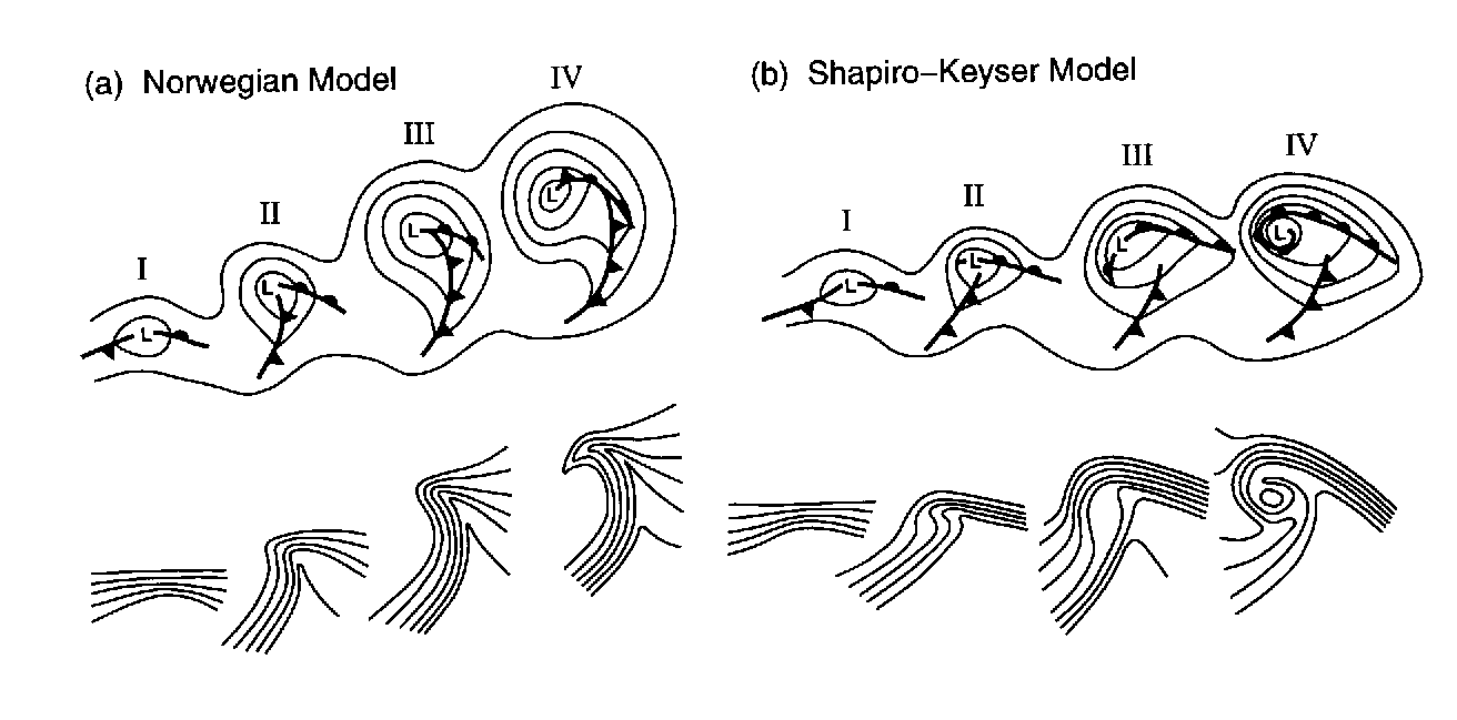
development is known as the Norwegian Cyclone Model, developed during and shortly after World War I
World War I
World War I , which was predominantly called the World War or the Great War from its occurrence until 1939, and the First World War or World War I thereafter, was a major war centred in Europe that began on 28 July 1914 and lasted until 11 November 1918...
within the Bergen School of Meteorology
Bergen School of Meteorology
The "Bergen School of Meteorology" is a school of thought which is the basis for much of modern weather forecasting.Founded by the meteorologist Prof...
. In this theory, cyclone
Cyclone
In meteorology, a cyclone is an area of closed, circular fluid motion rotating in the same direction as the Earth. This is usually characterized by inward spiraling winds that rotate anticlockwise in the Northern Hemisphere and clockwise in the Southern Hemisphere of the Earth. Most large-scale...
s develop as they move up and along a frontal boundary, eventually occluding
Occluded front
An occluded front is formed during the process of cyclogenesis when a cold front overtakes a warm front. When this occurs, the warm air is separated from the cyclone center at the Earth's surface...
and reaching a barotropic
Barotropic
In meteorology, a barotropic atmosphere is one in which the pressure depends only on the density and vice versa, so that isobaric surfaces are also isopycnic surfaces . The isobaric surfaces will also be isothermal surfaces, hence the geostrophic wind is independent of height...
ally cold environment. It was developed completely from surface-based weather observations
Surface weather observation
Surface weather observations are the fundamental data used for safety as well as climatological reasons to forecast weather and issue warnings worldwide. They can be taken manually, by a weather observer, by computer through the use of automated weather stations, or in a hybrid scheme using...
, including descriptions of cloud
Cloud
A cloud is a visible mass of liquid droplets or frozen crystals made of water and/or various chemicals suspended in the atmosphere above the surface of a planetary body. They are also known as aerosols. Clouds in Earth's atmosphere are studied in the cloud physics branch of meteorology...
s found near frontal boundaries
Weather front
A weather front is a boundary separating two masses of air of different densities, and is the principal cause of meteorological phenomena. In surface weather analyses, fronts are depicted using various colored lines and symbols, depending on the type of front...
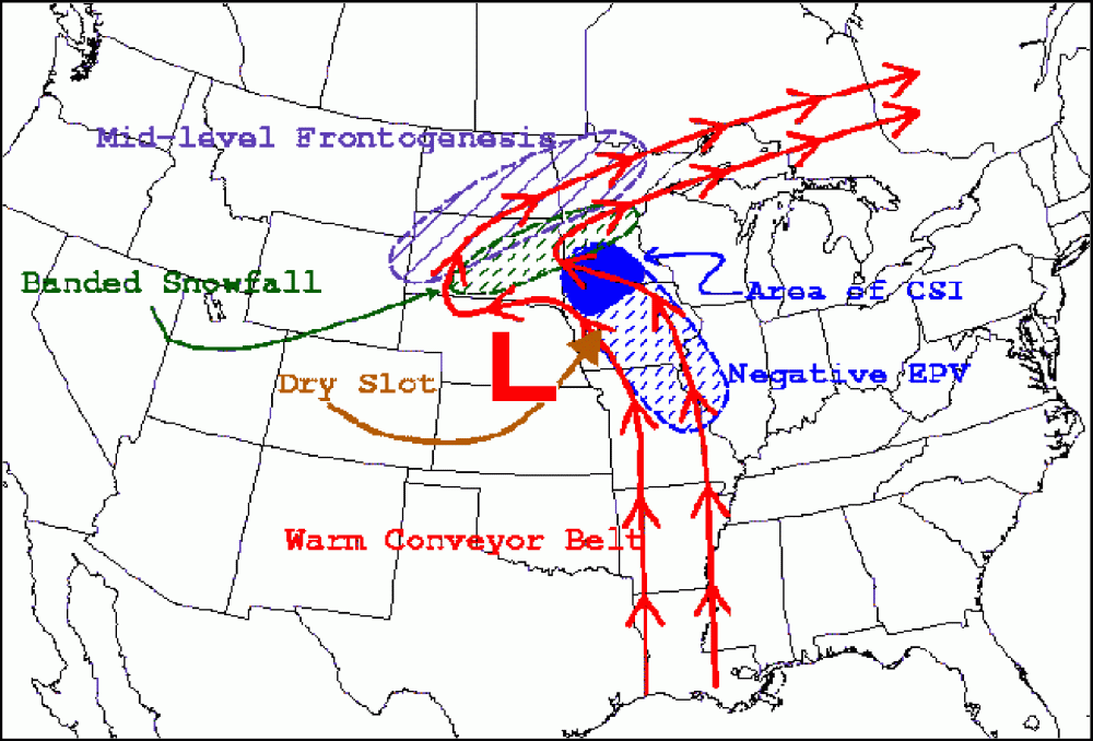
. Developed from this model was the concept of the warm conveyor belt, which transports warm and moist air just ahead of the cold front
Cold front
A cold front is defined as the leading edge of a cooler mass of air, replacing a warmer mass of air.-Development of cold front:The cooler and denser air wedges under the less-dense warmer air, lifting it...
above the surface warm front
Warm front
A warm front is a density discontinuity located at the leading edge of a homogeneous warm air mass, and is typically located on the equator-facing edge of an isotherm gradient...
.
Development of the theory
Polar front theory is attributed to Jacob BjerknesJacob Bjerknes
Jacob Aall Bonnevie Bjerknes was a Norwegian-American meteorologist. -Background:Jacob Aall Bonnevie Bjerknes was born in Stockholm, Sweden. His father was the Norwegian meteorologist Vilhelm Bjerknes, one of the pioneers of modern weather forecasting. His paternal grandfather was noted...
, derived from a coastal network of observation sites in Norway
Norway
Norway , officially the Kingdom of Norway, is a Nordic unitary constitutional monarchy whose territory comprises the western portion of the Scandinavian Peninsula, Jan Mayen, and the Arctic archipelago of Svalbard and Bouvet Island. Norway has a total area of and a population of about 4.9 million...
during World War I
World War I
World War I , which was predominantly called the World War or the Great War from its occurrence until 1939, and the First World War or World War I thereafter, was a major war centred in Europe that began on 28 July 1914 and lasted until 11 November 1918...
. This theory proposed that the main inflow into a cyclone was concentrated along two lines of convergence
Convergence zone
Convergence zone usually refers to a region in the atmosphere where two prevailing flows meet and interact, usually resulting in distinctive weather conditions....
, one ahead of the low and another trailing behind the low. The convergence line ahead of the low became known as either the steering line or the warm front. The trailing convergence zone was referred to as the squall line
Squall line
A squall line is a line of severe thunderstorms that can form along or ahead of a cold front. In the early 20th century, the term was used as a synonym for cold front. It contains heavy precipitation, hail, frequent lightning, strong straight-line winds, and possibly tornadoes and waterspouts....
or cold front. Areas of clouds and rain
Rain
Rain is liquid precipitation, as opposed to non-liquid kinds of precipitation such as snow, hail and sleet. Rain requires the presence of a thick layer of the atmosphere to have temperatures above the melting point of water near and above the Earth's surface...
fall appeared to be focused along these convergence zones. The concept of frontal zones led to the concept of air mass
Air mass
In meteorology, an air mass is a volume of air defined by its temperature and water vapor content. Air masses cover many hundreds or thousands of square miles, and adopt the characteristics of the surface below them. They are classified according to latitude and their continental or maritime...
es. The nature of the three-dimensional structure of the cyclone would wait for the development of the upper air network during the 1940s.
Evolution
A wave along a frontal boundary, in the form of a broad area of low pressureLow pressure area
A low-pressure area, or "low", is a region where the atmospheric pressure at sea level is below that of surrounding locations. Low-pressure systems form under areas of wind divergence which occur in upper levels of the troposphere. The formation process of a low-pressure area is known as...
, develops as an upper level disturbance moves towards that portion of the boundary. Precipitation
Precipitation (meteorology)
In meteorology, precipitation In meteorology, precipitation In meteorology, precipitation (also known as one of the classes of hydrometeors, which are atmospheric water phenomena is any product of the condensation of atmospheric water vapor that falls under gravity. The main forms of precipitation...
will begin to form ahead of the surface low, within the cold sector of the cyclone poleward of the warm front
Warm front
A warm front is a density discontinuity located at the leading edge of a homogeneous warm air mass, and is typically located on the equator-facing edge of an isotherm gradient...
. As the low deepens, both the cold
Cold front
A cold front is defined as the leading edge of a cooler mass of air, replacing a warmer mass of air.-Development of cold front:The cooler and denser air wedges under the less-dense warmer air, lifting it...
and warm fronts around the low become better defined. As the low matures, it couples with the upper level disturbance moving into the cyclone's cold sector. The cold front catches up to the westward portion of the warm front, forming an occluded front
Occluded front
An occluded front is formed during the process of cyclogenesis when a cold front overtakes a warm front. When this occurs, the warm air is separated from the cyclone center at the Earth's surface...
. Eventually, the cyclone stacks with the upper level disturbance, becoming isolated within the cold sector, and begins to weaken as it becomes far removed from the original temperature discontinuity along the cold and warm fronts. At this point, it becomes a cold-core low
Cold-core low
A cold-core low, also known as a cold low or cold-core cyclone, is a cyclone aloft which has an associated cold pool of air residing at high altitude within the Earth's troposphere. It is a low pressure system which strengthens with height in accordance with the thermal wind relationship. These...
. The frontal boundary becomes weaker and surrounds the equatorward portion of the cyclone, waiting for the next upper level disturbance to form a new low pressure area.
Conveyor belt

Westerlies
The Westerlies, anti-trades, or Prevailing Westerlies, are the prevailing winds in the middle latitudes between 30 and 60 degrees latitude, blowing from the high pressure area in the horse latitudes towards the poles. These prevailing winds blow from the west to the east, and steer extratropical...
. However, the western portion of this belt wraps around the northwest (southwest in the Southern Hemisphere) side of the cyclone, which can contain moderate to heavy precipitation. If the air mass is cold enough, the precipitation falls the form in heavy snow
Snow
Snow is a form of precipitation within the Earth's atmosphere in the form of crystalline water ice, consisting of a multitude of snowflakes that fall from clouds. Since snow is composed of small ice particles, it is a granular material. It has an open and therefore soft structure, unless packed by...
. Theory from the 1980's talked about the presence of a cold conveyor belt which originates north of the warm front and flows along a clockwise path (in the northern hemisphere) into the main belt of the westerlies aloft, but there has been conflicting evidence as to whether or not it actually exists.

