

Southern Sixers
Encyclopedia
In peak bagging
terminology in the United States
, the Southern Sixers refers to the group of mountains in the southern states of North Carolina
and Tennessee
with heights of at least six thousand feet (1829 m). The southern sixers are the tallest group of mountains in the eastern United States and the only peaks in the Appalachian Mountains
besides New Hampshire
's Mount Washington
to exceed 6,000 feet.
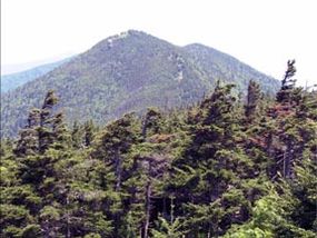
Most of these mountains are located in Great Smoky Mountains National Park
(abbreviated GSMNP in the list), Mount Mitchell State Park
(MMSP), along the Blue Ridge Parkway
(BRP), or in Cherokee
or Pisgah National Forest
. There are several, though, that are located on private property. All of these mountains are located within 32 miles (51.5 km) of the North Carolina - Tennessee border
, with 12 on the state border itself and many more on various county borders.
Those who complete a list of 40 of these peaks are awarded membership in the South Beyond 6000 club.
The locator map below shows the locations of those Southern Sixers with more than one thousand feet of topographic prominence or considerable isolation
.
Peak bagging
Peak bagging is an activity in which hillwalkers and mountaineers attempt to reach the summit of some collection of peaks, usually those above some height in a particular region, or having a particular feature.Peak bagging can be distinguished from highpointing...
terminology in the United States
United States
The United States of America is a federal constitutional republic comprising fifty states and a federal district...
, the Southern Sixers refers to the group of mountains in the southern states of North Carolina
North Carolina
North Carolina is a state located in the southeastern United States. The state borders South Carolina and Georgia to the south, Tennessee to the west and Virginia to the north. North Carolina contains 100 counties. Its capital is Raleigh, and its largest city is Charlotte...
and Tennessee
Tennessee
Tennessee is a U.S. state located in the Southeastern United States. It has a population of 6,346,105, making it the nation's 17th-largest state by population, and covers , making it the 36th-largest by total land area...
with heights of at least six thousand feet (1829 m). The southern sixers are the tallest group of mountains in the eastern United States and the only peaks in the Appalachian Mountains
Appalachian Mountains
The Appalachian Mountains #Whether the stressed vowel is or ,#Whether the "ch" is pronounced as a fricative or an affricate , and#Whether the final vowel is the monophthong or the diphthong .), often called the Appalachians, are a system of mountains in eastern North America. The Appalachians...
besides New Hampshire
New Hampshire
New Hampshire is a state in the New England region of the northeastern United States of America. The state was named after the southern English county of Hampshire. It is bordered by Massachusetts to the south, Vermont to the west, Maine and the Atlantic Ocean to the east, and the Canadian...
's Mount Washington
Mount Washington (New Hampshire)
Mount Washington is the highest peak in the Northeastern United States at , famous for dangerously erratic weather. For 76 years, a weather observatory on the summit held the record for the highest wind gust directly measured at the Earth's surface, , on the afternoon of April 12, 1934...
to exceed 6,000 feet.
Most of these mountains are located in Great Smoky Mountains National Park
Great Smoky Mountains National Park
Great Smoky Mountains National Park is a United States National Park and UNESCO World Heritage Site that straddles the ridgeline of the Great Smoky Mountains, part of the Blue Ridge Mountains, which are a division of the larger Appalachian Mountain chain. The border between Tennessee and North...
(abbreviated GSMNP in the list), Mount Mitchell State Park
Mount Mitchell State Park
Mount Mitchell State Park is a North Carolina state park in Yancey County, North Carolina in the United States. Established in 1915 by the state legislature, it became the first state park of North Carolina...
(MMSP), along the Blue Ridge Parkway
Blue Ridge Parkway
The Blue Ridge Parkway is a National Parkway and All-American Road in the United States, noted for its scenic beauty. It runs for 469 miles , mostly along the famous Blue Ridge, a major mountain chain that is part of the Appalachian Mountains...
(BRP), or in Cherokee
Cherokee National Forest
The Cherokee National Forest is a large National Forest created on July 19, 1936, by U.S. President Franklin Roosevelt, operated by the U.S. Forest Service and encompassing some 640,000 acres .-Location:...
or Pisgah National Forest
Pisgah National Forest
Pisgah National Forest is a National Forest in the Appalachian Mountains of western North Carolina. It is administered by the United States Forest Service, part of the United States Department of Agriculture. The Pisgah National Forest is completely contained within the state of North Carolina...
. There are several, though, that are located on private property. All of these mountains are located within 32 miles (51.5 km) of the North Carolina - Tennessee border
Frontier
A frontier is a political and geographical term referring to areas near or beyond a boundary. 'Frontier' was absorbed into English from French in the 15th century, with the meaning "borderland"--the region of a country that fronts on another country .The use of "frontier" to mean "a region at the...
, with 12 on the state border itself and many more on various county borders.
Those who complete a list of 40 of these peaks are awarded membership in the South Beyond 6000 club.
| Rank Ranking A ranking is a relationship between a set of items such that, for any two items, the first is either 'ranked higher than', 'ranked lower than' or 'ranked equal to' the second.... |
Peak Name Summit (topography) In topography, a summit is a point on a surface that is higher in elevation than all points immediately adjacent to it. Mathematically, a summit is a local maximum in elevation... |
Elevation (ft) | Range Mountain range A mountain range is a single, large mass consisting of a succession of mountains or narrowly spaced mountain ridges, with or without peaks, closely related in position, direction, formation, and age; a component part of a mountain system or of a mountain chain... |
Land |  |
 |
Prominence | Isolation Topographic isolation The topographic isolation of a summit is the minimum horizontal distance to the nearest point of higher elevation. Topographic isolation represents a radius of dominance in which the summit is the highest point. Topographic isolation can be calculated for small hills and islands as well as for... |
|---|---|---|---|---|---|---|---|---|
| 1 | Mount Mitchell Mount Mitchell Mount Mitchell can refer to:* Mount Mitchell, the highest point in the eastern United States* Mount Mitchell , in Jasper National Park of Canada* Mount Mitchell * Mount Mitchell , in Queensland... |
6,684 | Black Mountains Black Mountains (North Carolina) The Black Mountains are a mountain range in western North Carolina, in the southeastern United States. They are part of the Blue Ridge Province of the Southern Appalachian Mountains. The Blacks are the highest mountains in the Eastern United States... |
MMSP | Yancey County | 6,089 | 1,189 | |
| 2 | Mount Craig Mount Craig (North Carolina) Mount Craig, , is the second highest peak of the Appalachian Mountains and second only to Mount Mitchell in eastern North America. It is located in the Black Mountains in Yancey County, North Carolina. The mountain lies just north of Mt... |
6,647 | Black Mtns | MMSP | Yancey | 287 | .91 | |
| 3 | Clingmans Dome Clingmans Dome Clingmans Dome is a mountain in the Great Smoky Mountains of Tennessee and North Carolina, in the southeastern United States. At an elevation of , it is the highest mountain in the Smokies, the highest point in the state of Tennessee, and the highest point along the Appalachian Trail... |
6,643 | Great Smoky Mountains Great Smoky Mountains The Great Smoky Mountains are a mountain range rising along the Tennessee–North Carolina border in the southeastern United States. They are a subrange of the Appalachian Mountains, and form part of the Blue Ridge Physiographic Province. The range is sometimes called the Smoky Mountains or the... |
GSMNP | Sevier County Sevier County, Tennessee Sevier County is a county of the state of Tennessee, United States. Its population was 71,170 at the 2000 United States Census. It is included in the Sevierville, Tennessee, Micropolitan Statistical Area, which is included in the Knoxville-Sevierville-La Follette, TN Combined Statistical Area. The... |
Swain County | 4,513 | 70.64 |
| 4 | Mount Guyot Mount Guyot (Great Smoky Mountains) Mount Guyot is a mountain in the eastern Great Smoky Mountains, located inthe southeastern United States. At above sea level, Guyot is the fourth-highestsummit in the eastern U.S., and the second-highest in the Great Smoky Mountains National Park... |
6,621 | Great Smoky Mtns | GSMNP | Sevier | Haywood | 1,581 | 16.73 |
| 5 | Balsam Cone | 6,611 | Black Mtns | MMSP | Yancey | 171 | .88 | |
| 6 | Cattail Peak | 6,600 | Black Mtns | MMSP | Yancey | 120 | .62 | |
| 7 | Mount LeConte | 6,593 | Great Smoky Mtns | GSMNP | Sevier | 1,360 | 7.21 | |
| 8 | Mount Buckley Mount Buckley Mount Buckley is an ice-free peak, high, which is the central and highest summit of Buckley Island, a mountain massif at the head of Beardmore Glacier. It was discovered by the British Antarctic Expedition, 1907–09, and named for George Buckley of New Zealand, a supporter of the expedition.... |
6,580 | Great Smoky Mtns | GSMNP | Sevier | Swain | 60 | .42 |
| 9 | Mount Gibbes | 6,571 | Black Mtns | WMIT | Yancey | 111 | 2.35 | |
| 10 | Big Tom | 6,560 | Black Mtns | MMSP | Yancey | .19 | ||
| 11 | Clingmans Peak | 6,557 | Black Mtns | WMIT | Yancey | 497 | .02 | |
| 12 | Potato Hill | 6,475 | Black Mtns | Pisgah | Yancey | 80 | .29 | |
| 13 | Mount Love | 6,446 | Great Smoky Mtns | GSMNP | Sevier | Swain | 106 | .41 |
| 14 | Mount Chapman Mount Chapman Mount Chapman is a mountain in the Great Smoky Mountains, located in the Southeastern United States. It has an elevation of 6,417 feet above sea level. While the mountain is located deep within the Great Smokies, the Appalachian Trail crosses its eastern slope, coming to within of the summit... |
6,417 | Great Smoky Mtns | GSMNP | Sevier | Swain | 577 | 1.48 |
| 15 | Richland Balsam Richland Balsam Richland Balsam is a mountain in the Great Balsam Mountains in the U.S. state of North Carolina. Rising to an elevation of , it is the highest mountain in the Great Balsam range and is among the 20 highest summits in the Appalachian range. The Blue Ridge Parkway reaches an elevation of —... |
6,410 | Great Balsam Mountains Great Balsam Mountains The Great Balsam Mountains, or Balsam Mountains, are in the mountain region of western North Carolina, United States. The Great Balsams are a subrange of the Blue Ridge Mountains, which in turn are a part of the Appalachian Mountains... |
BRP | Haywood | 1,000 | 27.13 | |
| 16 | Potato Knob | 6,400 | Black Mtns | BRP | Buncombe, Yancey | 40 | .45 | |
| 17 | Old Black Old Black (Great Smoky Mountains) Old Black is a mountain in the Great Smoky Mountains, located in the Southeastern United States. While often overshadowed by Mount Guyot, its higher neighbor to the south, Old Black is the 4th-highest mountain in... |
6,370 | Great Smoky Mtns | GSMNP | Sevier, Cocke County | Haywood | 170 | .70 |
| 18 | Blackstock Knob | 6,359 | Black Mtns | BRP | Buncombe, Yancey | 480 | 1.64 | |
| 19 | Celo Knob Celo Knob Celo Knob is the northern most major peak in the Black Mountains of western North Carolina. It is located just north of Mount Mitchell State Park in the Pisgah National Forest.... |
6,327 | Black Mtns | Yancey | 647 | 3.52 | ||
| 20 | Mount Hallback | 6,320 | Black Mtns | MMSP | Yancey | 200 | 1.11 | |
| 21 | Waterrock Knob Waterrock Knob Waterrock Knob is a mountain peak in the U.S. state of North Carolina. It is the highest peak in the Plott Balsams and is the 16th highest mountain in the Eastern United States. It is the 15th highest of the 40 mountains in North Carolina over 6000 feet.... |
6,292 | Plott Balsams Plott Balsams The Plott Balsams are a mountain range in western North Carolina, in the southeastern United States. They are part of the Blue Ridge Mountain Province of the Southern Appalachian Mountains. The Plott Balsams stretch from the city of Sylva in the Tuckasegee River valley to the southwest to Maggie... |
BRP | Haywood, Jackson County Jackson County, North Carolina Jackson County is a county located in the southwest of the U.S. state of North Carolina. As of 2010, the population was 40,271. Since 1913 its county seat has been Sylva, replacing Webster.-History:... |
1,947 | 10.66 | |
| 22 | Roan High Knob Roan Mountain (Roan Highlands) Roan Mountain is the highpoint of the Roan-Unaka Range of the Southern Appalachian Mountains, located in the Southeastern United States. The mountain is clad in a dense stand of Southern Appalachian spruce-fir forest, and includes the world's largest natural rhododendron garden, and the longest... |
6,285 | Unaka Mountains | Cherokee / Pisgah | Carter County Carter County, Tennessee Carter County is a county located in the U.S. state of Tennessee. As of 2010, the population was 57,424. Its county seat is Elizabethton.Carter County is part of the Johnson City Metropolitan Statistical Area, which is a component of the Johnson City–Kingsport–Bristol, TN-VA Combined... |
Mitchell County Mitchell County, North Carolina -National protected areas:* Blue Ridge Parkway * Pisgah National Forest -Demographics:As of the census of 2000, there were 15,687 people, 6,551 households, and 4,736 families residing in the county. The population density was 71 people per square mile . There were 7,919 housing units at an... |
3,485 | 18.81 |
| 23 | Roan High Bluff | 6,267 | Unaka Mountains | Pisgah | Mitchell | 1.54 | ||
| 24 | Browning Knob | 6,240 | Plott Balsams | BRP | Haywood, Jackson | 160 | .33 | |
| 25 | Luftee Knob | 6,234 | Great Smoky Mtns | GSMNP | Haywood, Swain | 434 | 2.53 | |
| 26 | Gibbs Mountain | 6,224 | Black Mtns | Yancey | 120 | .81 | ||
| 27 | Mount Lyn Lowryhttp://www.virtualblueridge.com/parkway_tour/overlooks/00445.asp | 6,220 | Plott Balsams | Haywood, Jackson | 380 | 1.22 | ||
| 28 | Mount Kephart Mount Kephart Mount Kephart is a mountain in the central Great Smoky Mountains, located in the Southeastern United States. The Appalachian Trail crosses the mountain's south slope, making it a key destination for thru-hikers. The Jumpoff, a cliff on the northeast side of the mountain, allows for spectacular... |
6,217 | Great Smoky Mtns | GSMNP | Sevier | Swain | 660 | 3.09 |
| 29 | Black Balsam Knob Black Balsam Knob Black Balsam Knob, also known as Black Balsam Bald, is in the Pisgah National Forest southwest of Asheville, NC near milepost 420 on the Blue Ridge Parkway.... |
6,214 | Great Balsam Mtns | BRP | Haywood | 989 | 7.08 | |
| 30 | Winter Star Mountain | 6,212 | Black Mtns | Yancey | 532 | 1.13 | ||
| 31 | Percys Peak | 6,200 | Black Mtns | Yancey | .32 | |||
| 32 | Grassy Ridge Bald Grassy Ridge Bald Grassy Ridge Bald is a mountain in North Carolina and is part of the Roan Highlands, within the Pisgah National Forest. Its elevation reaches 6,165 feet and it is on the border between Avery and Mitchell counties. The mountain generates feeder streams for the North Toe River.... |
6,189 | Unaka Mountains | Pisgah | Mitchell, Avery County | 2.35 | ||
| 33 | Mount Collins Mount Collins Mount Collins is a mountain in the Great Smoky Mountains, located in the Southeastern United States. It has an elevation of above sea level. Located along the Appalachian Trail between Clingmans Dome and Newfound Gap, the mountain is a popular destination for thru-hikers. A backcountry shelter... |
6,188 | Great Smoky Mtns | GSMNP | Sevier | Swain | 465 | 1.80 |
| 34 | Marks Knob Marks Knob Marks Knob is a mountain in the Great Smoky Mountains, in the southeastern United States. It has an elevation of , with of clean prominence. Its summit— located near the center of the Eastern Smokies amidst a dense stand of Southern Appalachian spruce-fir forest— is a popular... |
6,169 | Great Smoky Mtns | GSMNP | Swain | 369 | 1.34 | |
| 35 | Big Cataloochee Mountain Cataloochee (Great Smoky Mountains) Cataloochee is a valley in the Great Smoky Mountains of North Carolina, located in the Southeastern United States. Now a recreational and historic area within the Great Smoky Mountains National Park, Cataloochee was once home to a substantial Appalachian community and Cherokee hunting... |
6,155 | Great Smoky Mtns | GSMNP | Haywood | 675 | 2.61 | |
| 36 | Mount Hardison | 6,134 | Great Smoky Mtns | GSMNP | Swain | 254 | .60 | |
| 37 | Tricorner Knob Tricorner Knob Tricorner Knob is a mountain in the Great Smoky Mountains, located in the Southeastern United States. It has an elevation of 6,120 feet , with 160 feet of clean prominence. The Appalachian Trail and Balsam Mountain Trail intersect near the mountain's summit, making Tricorner Knob the great... |
6,120 | Great Smoky Mtns | GSMNP | Sevier | Haywood, Swain | 160 | .55 |
| 38 | Mount Yonaguska | 6,120 | Great Smoky Mtns | GSMNP | Haywood, Swain | 40 | .33 | |
| 39 | Mount Ambler | 6,120 | Great Smoky Mtns | GSMNP | Sevier | Swain | 86 | .45 |
| 40 | Mount Hardy Mount Hardy Mount Hardy is a mountain standing close east of Mount Oldfield in the northwest part of the Tula Mountains, in Enderby Land. It was plotted from air photos taken from ANARE aircraft in 1956 and was named by the Antarctic Names Committee of Australia for K. Hardy, a weather observer at Wilkes... |
6,110 | Great Balsam Mtns | Haywood, Jackson | 760 | 3.46 | ||
| 41 | Craggy Domehttp://www.virtualblueridge.com/parkway_tour/overlooks/00364.asp | 6,105 | Great Craggy Mountains Great Craggy Mountains The Great Craggy Mountains, commonly called the Craggies, are a mountain range in western North Carolina, United States. They are a subrange of the Blue Ridge Mountains and encompass an area of approx. 194 sq mi . They are situated in Buncombe County, North Carolina, 14 miles northeast of Asheville... |
Buncombe County | 785 | 3.49 | ||
| 42 | Plott Balsamhttp://www.virtualblueridge.com/parkway_tour/overlooks/00458.asp | 6,088 | Plott Balsams | Haywood | 408 | 1.69 | ||
| 43 | Thermo Knob | 6,080 | Great Smoky Mtns | GSMNP | Haywood, Swain | 60 | .62 | |
| 44 | Reinhart Knob | 6,080 | Great Balsam Mtns | Haywood, Jackson | 200 | 1.41 | ||
| 45 | Sam Knob | 6,050 | Great Balsam Mtns | Haywood | 360 | 1.15 | ||
| 46 | Shining Rock Shining Rock Shining Rock is a mountain in western North Carolina. The mountain is one of the Great Balsam Mountains which are a part of the Blue Ridge Mountains within the Appalachian Mountains. It is the 38th tallest mountain in the eastern United States.... |
6,040 | Great Balsam Mtns | Haywood | 320 | 2.87 | ||
| 47 | Grassy Cove Top | 6,040 | Great Balsam Mtns | Haywood | 320 | 1.37 | ||
| 48 | Tennent Mountain | 6,040 | Great Balsam Mtns | Haywood | 120 | .71 | ||
| 49 | Patton Knob | 6,040 | Black Mtns | BRP | Buncombe, Yancey | .80 | ||
| 50 | Chestnut Bald | 6,040 | Great Balsam Mtns | Transylvania County, Haywood | 1.67 | |||
| 51 | Yellow Face | 6,032 | Plott Balsams | Jackson | 1.16 | |||
| 52 | Cold Mountainhttp://www.virtualblueridge.com/parkway_tour/overlooks/00412a.asp | 6,030 | Great Balsam Mtns | Haywood | 990 | 2.86 | ||
| 53 | Mount Sequoyah Mount Sequoyah Mount Sequoyah is a mountain in the Great Smoky Mountains, located inthe Southeastern United States. It has an elevation of 6,003 feet above sea level... |
6,003 | Great Smoky Mtns | GSMNP | Sevier | Swain | 163 | 1.28 |
The locator map below shows the locations of those Southern Sixers with more than one thousand feet of topographic prominence or considerable isolation
Topographic isolation
The topographic isolation of a summit is the minimum horizontal distance to the nearest point of higher elevation. Topographic isolation represents a radius of dominance in which the summit is the highest point. Topographic isolation can be calculated for small hills and islands as well as for...
.