

Marks Knob
Encyclopedia
Great Smoky Mountains
The Great Smoky Mountains are a mountain range rising along the Tennessee–North Carolina border in the southeastern United States. They are a subrange of the Appalachian Mountains, and form part of the Blue Ridge Physiographic Province. The range is sometimes called the Smoky Mountains or the...
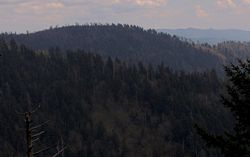
, in the southeastern United States. It has an elevation of 6169 feet (1,880.3 m), with 249 feet (75.9 m) of clean prominence. Its summit— located near the center of the Eastern Smokies amidst a dense stand of Southern Appalachian spruce-fir forest
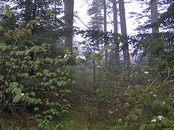
Southern Appalachian spruce-fir forest
The Southern Appalachian spruce-fir forest is a type of montane coniferous forest that grows in the highest elevations in the southern Appalachian Mountains of the eastern United States...
— is a popular bushwhacking destination and one of the most difficult-to-reach summits of the Southern Sixers
Southern Sixers
In peak bagging terminology in the United States, the Southern Sixers refers to the group of mountains in the southern states of North Carolina and Tennessee with heights of at least six thousand feet...
.
Marks Knob is the higher of the two peaks that crown Dashoga Ridge (Mount Hardison is the other). Dashoga Ridge descends from its intersection with the Balsam Mountain crest on the slopes of Mount Yonaguska southward to the remote upper Raven Fork Valley. The ridge runs roughly parallel to the main Great Smokies crest, which is just opposite the valley to the west. Marks Knob consists of two peaks, with the southern-most peak being the true summit. The mountain is located entirely within Swain County, North Carolina
Swain County, North Carolina
Swain County is a county located in the U.S. state of North Carolina. As of 2000, the population was 12,968. Its county seat is Bryson City.Swain County is home of the Nantahala River . The Nantahala is one of the most popular whitewater rafting rivers in the nation...
. Raven Fork, which drains Dashoga Ridge, is part of the Oconaluftee River watershed. The rocks comprising Dashoga Ridge consist mainly of Precambrian
Precambrian
The Precambrian is the name which describes the large span of time in Earth's history before the current Phanerozoic Eon, and is a Supereon divided into several eons of the geologic time scale...
metamorphic sandstones of the Ocoee Supergroup.
Unlike most of the high peaks of the Eastern Smokies, neither the Tennessee-North Carolina state boundary nor any county lines traverse the summit of Marks Knob, and thus the mountain received little attention for most of recorded history. Trail guides from the early 1930s refer to the mountain as "Cam's Knob" and list its elevation as greater than 6,140 feet. In the 1920s and early 1930s, two trails— the Rosser Trail and an unnamed spur trail— connected Dashoga Ridge to the logging camps at Smokemont to the southwest and Straight Fork to the southeast. The Rosser Trail ascended northeastward from Smokemont (namely, the Chasteen Creek area) across Hughes Ridge to Enloe Creek, and then over Highland Ridge to the Raven Fork Valley. The trail continued northward along Raven Fork around the western base of Breakneck Ridge to an area known as Three Forks, where the Left, Middle, and Right prongs of Raven Fork converge to form Raven Fork proper. Beyond Three Forks, the trail wound its way northward up the crest of Dashoga Ridge, crossing the summits of Marks Knob and Mount Hardison before joining the Balsam Mountain Trail. The area's only other trail ascended northwestward from Straight Fork, crossing Hyatt Ridge to McGee Springs. The trail then turned westward to traverse the crest of Breakneck Ridge and descend to Three Forks, where it joined the Rosser Trail. By 1974, the Hyatt Ridge Trail had been developed along the crest of Hyatt Ridge, rising northward along the ridgecrest from Straight Fork and approaching Dashoga Ridge from the east.
Reaching the summit of Marks Knob requires a long, uphill hike followed by a 1 miles (1.6 km) bushwhack across the heavily overgrown Hyatt Ridge Trail. The Balsam Mountain Trail, which crosses the gap between Mount Hardison and Mount Yonaguska, provides the closest maintained trail access.
The old Hyatt Ridge Trail intersects the Balsam Mountain Trail at a sharp, horseshoe bend approximately 0.8 miles (1.3 km) east of the latter's junction with the Appalachian Trail
Appalachian Trail
The Appalachian National Scenic Trail, generally known as the Appalachian Trail or simply the AT, is a marked hiking trail in the eastern United States extending between Springer Mountain in Georgia and Mount Katahdin in Maine. It is approximately long...
at Tricorner Knob
Tricorner Knob
Tricorner Knob is a mountain in the Great Smoky Mountains, located in the Southeastern United States. It has an elevation of 6,120 feet , with 160 feet of clean prominence. The Appalachian Trail and Balsam Mountain Trail intersect near the mountain's summit, making Tricorner Knob the great...
. One branch (very faint) of the old Hyatt Ridge Trail crosses the summits of Mount Hardison and Marks Knob, and another swings around the western slope of Mount Hardison to the gap (or "saddle") between Mount Hardison and Marks Knob before descending to Three Forks. Both branches are riddled with blowdowns, but discernible. The old Hyatt/Balsam junction is located just over 10 miles (16.1 km) from the Balsam Mountain Trailhead at Pin Oak Gap (along Straight Fork Road) and just over 9 miles (14.5 km) from Cosby Campground
Cosby, Tennessee
Cosby is an unincorporated community in Cocke County, Tennessee, United States. Although it is not a census-designated place, the ZIP Code Tabulation Area for the ZIP Code that serves Cosby had a population of 5,201 as of the 2000 U.S. Census...
(via the Snake Den Ridge Trail
Snake Den Ridge Trail
The Snake Den Ridge Trail is an American hiking trail in the Great Smoky Mountains National Park of Cocke County, Tennessee. Winding its way up the backbone-like crest of Snake Den Ridge, the trail connects the Cosby Campground to the Appalachian Trail and provides the quickest access to the high...
and the Appalachian Trail).
External links
- Great Smoky Mountains National Park Trail Map — .pdf file
- Marks Knob — Peakbagger.com
- A Southern Mountaineer's Nemesis — SummitPost.org
- Bushwhack from Hell — trip report on the bushwhack from the Balsam Mountain Trail to the Raven Fork Valley at SummitPost.org.
- South Beyond 6000 in the Smokies - Details on climbing Marks Knob and other nearby mountains. Provided by the Carolina Hiking Club.