
Black Balsam Knob
Encyclopedia
Black Balsam Knob, also known as Black Balsam Bald, is in the Pisgah National Forest
southwest of Asheville, NC near milepost 420 on the Blue Ridge Parkway
.
It is the second highest mountain in the Great Balsam Mountains
. The Great Balsams are within the Blue Ridge Mountains
, which are part of the Appalachian Mountains
. It is the 23rd highest of the 40 mountains in North Carolina over 6000 feet.
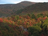
The top of the mountain is a grassy bald
that affords a panoramic view. The origin of grassy balds in southern Haywood county is a result of extensive clear-cut logging and locomotive fires in 1925 and 1942. These fires burned deep down into the mineral-rich topsoil slowing reforestation or stopping it altogether. Examples of this cannot only be found on Black Balsam knob, but many of its neighboring peaks and ridges. These unique features contribute greatly to the area's popularity, but the heavy amount of foot traffic also does further damage to this already fragile ecosystem.
The Art Loeb Trail
follows the grassy ridge of Black Balsam Knob.
Visible peaks from Black Balsam Knob include:
Pisgah National Forest
Pisgah National Forest is a National Forest in the Appalachian Mountains of western North Carolina. It is administered by the United States Forest Service, part of the United States Department of Agriculture. The Pisgah National Forest is completely contained within the state of North Carolina...
southwest of Asheville, NC near milepost 420 on the Blue Ridge Parkway
Blue Ridge Parkway
The Blue Ridge Parkway is a National Parkway and All-American Road in the United States, noted for its scenic beauty. It runs for 469 miles , mostly along the famous Blue Ridge, a major mountain chain that is part of the Appalachian Mountains...
.
It is the second highest mountain in the Great Balsam Mountains
Great Balsam Mountains
The Great Balsam Mountains, or Balsam Mountains, are in the mountain region of western North Carolina, United States. The Great Balsams are a subrange of the Blue Ridge Mountains, which in turn are a part of the Appalachian Mountains...
. The Great Balsams are within the Blue Ridge Mountains
Blue Ridge Mountains
The Blue Ridge Mountains are a physiographic province of the larger Appalachian Mountains range. This province consists of northern and southern physiographic regions, which divide near the Roanoke River gap. The mountain range is located in the eastern United States, starting at its southern-most...
, which are part of the Appalachian Mountains
Appalachian Mountains
The Appalachian Mountains #Whether the stressed vowel is or ,#Whether the "ch" is pronounced as a fricative or an affricate , and#Whether the final vowel is the monophthong or the diphthong .), often called the Appalachians, are a system of mountains in eastern North America. The Appalachians...
. It is the 23rd highest of the 40 mountains in North Carolina over 6000 feet.
The top of the mountain is a grassy bald
Appalachian balds
In the Appalachian Mountains of the eastern United States, balds are mountain summits or crests covered primarily by thick vegetation of native grasses or shrubs occurring in areas where heavy forest growth would be expected....
that affords a panoramic view. The origin of grassy balds in southern Haywood county is a result of extensive clear-cut logging and locomotive fires in 1925 and 1942. These fires burned deep down into the mineral-rich topsoil slowing reforestation or stopping it altogether. Examples of this cannot only be found on Black Balsam knob, but many of its neighboring peaks and ridges. These unique features contribute greatly to the area's popularity, but the heavy amount of foot traffic also does further damage to this already fragile ecosystem.
The Art Loeb Trail
Art Loeb Trail
The Art Loeb Trail is a trail located in Pisgah National Forest in Western North Carolina. The Northern Terminus is at the Daniel Boone Boy Scout Camp in Haywood County, while the trail's southern Terminus is located near the Davidson River Campground, near Brevard, in Transylvania County...
follows the grassy ridge of Black Balsam Knob.
Visible peaks from Black Balsam Knob include:
- Shining RockShining RockShining Rock is a mountain in western North Carolina. The mountain is one of the Great Balsam Mountains which are a part of the Blue Ridge Mountains within the Appalachian Mountains. It is the 38th tallest mountain in the eastern United States....
in the Shining Rock WildernessShining Rock WildernessThe Shining Rock Wilderness is a protected Wilderness Area in the U.S. state of North Carolina. Its first have been part of the National Wilderness Preservation System since the System was created in 1964...
(3 miles northeast) - Looking Glass RockLooking Glass RockLooking Glass Rock is a pluton monolith in the Appalachian Mountains of western North Carolina. The mountain is located within Pisgah National Forest about 5.5 miles northwest of Brevard and 25 miles southwest of Asheville...
(5 miles southeast) - Cold Mountain (6 miles north)
- Mount PisgahMount Pisgah (North Carolina)Mount Pisgah is a mountain in the Appalachian Mountain Range and part of the Blue Ridge Mountains of North Carolina, United States. The mountain's height is 5,721 feet and it sits approximately 15 miles southwest of Asheville near the crossing of the boundaries of Buncombe, Haywood, Henderson...
(9.5 miles northeast) - Mount MitchellMount Mitchell (North Carolina)Mount Mitchell is the highest peak of the Appalachian Mountains and the highest peak in the eastern United States. It was the highest point in any state of the United States until Texas joined the union in 1845. The nearest higher point east of the Rocky Mountains is Harney Peak in the Black Hills...
. On exceptionally clear days, Mount MitchellMount Mitchell (North Carolina)Mount Mitchell is the highest peak of the Appalachian Mountains and the highest peak in the eastern United States. It was the highest point in any state of the United States until Texas joined the union in 1845. The nearest higher point east of the Rocky Mountains is Harney Peak in the Black Hills...
, the highest point in the Eastern United States, is visible 45 miles north east.