

Shanhai Yudi Quantu
Encyclopedia
The Shanhai Yudi Quantu is a Chinese map which was published in 1607/1609 in the geographical treatise Sancai Tuhui
.
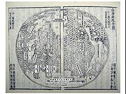 The Shanhai Yudi Quantu is known to have be highly influenced by the Jesuit missions in China, starting with the work of Matteo Ricci
. Matteo Ricci himself had several of his own maps entitled Shanhai Yudi Quantu: one engraved by Wu Zhongming and dated 1600, and one dated 1604, engraved by Guo Zizhang .
is marked phonetically "Yaxiya" . This is the area of the map where most information can be found, and has been subdivided here by regions:
 Numerous areas and islands are named in this part of the world:
The seas being mentioned are the China Sea
(Da Ming hai 大明海, lit. "Great Ming Sea", and the "Small Eastern Ocean" (Xiao Dong yang 小東洋). To the northwest, East Asia is delimitated by a desert area (shamo 沙漠), and to the north by the "Artic World" (北極界).
The two areas of Java
Major (Mu Zhaowa 木爪哇) and Java
Minor (Xiao Zhaowa 小爪哇) are shown far into the ocean, to the south, near the Antarctic.
Two seas are shown: the Bay of Bengal
(Banggela hai 旁葛臘海, phonetically), and the Western Indian Ocean or Persian Gulf
(Xiao Xi yang 小西洋, lit. "Small Western Ocean").
 Europe
is depicted as the landmass at the westernmost part of the Eurasian landmass. It is marked phonetically "Ouluoba" (歐羅巴). Only France
is named as a country , while others are marked as "more than thirty countries" . Greenland
is identified as well .
On the map, Europe is surrounded by the Atlantic (大西洋, "Great Western Ocean", still the modern name for the Atlantic) to the West, the Mediterranean (地中海, "Sea in the middle of the land", still the modern name for the Mediterranean) to the South, and the Black Sea
(Tai hai, 太海) to the East.
is described phonetically as North Ya-Mo-Li-Ja (Bei Yamolijia 北亞墨利加). A few locations are mentioned but remain unidentified:
is described phonetically as South Ya-Mo-Li-Ja (Nan Yamolija 南亞墨利加).
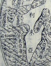 Africa
is described phonetically as Libya
(Liweiya 利未亞). The single mention of the African continent is that of the Atlas Mountains
(tianxia ci shan zhigao 天下此山至高 – "the greatest mountain of the world"). The African continent is surrounded by various seas, from North, clockwise:
is described phonetically as "Magellania" (Mowalanijia 墨瓦臘泥加), a name given to the continent at the time in honour of Magellan
. The map mentions how little is known about this continent: "Few have reached these southern regions, [therefore] the things [related to them] are not explored yet" (ci nanfang di ren zhi zhe shao, wei shen qi wu 此南方地人至者少, 未審其物).
Sancai Tuhui
The Sancai Tuhui, compiled by Shanghai natives Wang Qi and Wang Siyi , is a Chinese encyclopedia known at the time as a type of Book by category , completed in 1607 and published in 1609 during the Ming dynasty, featuring illustrations of subjects in the three worlds of heaven, earth, and...
.
Influences
Matteo Ricci
Matteo Ricci, SJ was an Italian Jesuit priest, and one of the founding figures of the Jesuit China Mission, as it existed in the 17th-18th centuries. His current title is Servant of God....
. Matteo Ricci himself had several of his own maps entitled Shanhai Yudi Quantu: one engraved by Wu Zhongming and dated 1600, and one dated 1604, engraved by Guo Zizhang .
Description
The locations in the map have been identified and translated by Roderich Ptak in his work The Sino-European Map (“Shanhai yudi quantu”) in the Encyclopedia Sancai tuhui:Asia
The Asian continentAsia
Asia is the world's largest and most populous continent, located primarily in the eastern and northern hemispheres. It covers 8.7% of the Earth's total surface area and with approximately 3.879 billion people, it hosts 60% of the world's current human population...
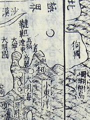
is marked phonetically "Yaxiya" . This is the area of the map where most information can be found, and has been subdivided here by regions:
East Asia
- The "Great Ming Empire"
- JapanJapanJapan is an island nation in East Asia. Located in the Pacific Ocean, it lies to the east of the Sea of Japan, China, North Korea, South Korea and Russia, stretching from the Sea of Okhotsk in the north to the East China Sea and Taiwan in the south...
- KoreaKoreaKorea ) is an East Asian geographic region that is currently divided into two separate sovereign states — North Korea and South Korea. Located on the Korean Peninsula, Korea is bordered by the People's Republic of China to the northwest, Russia to the northeast, and is separated from Japan to the...
- Jurchen area, northeast of KoreaKoreaKorea ) is an East Asian geographic region that is currently divided into two separate sovereign states — North Korea and South Korea. Located on the Korean Peninsula, Korea is bordered by the People's Republic of China to the northwest, Russia to the northeast, and is separated from Japan to the...
- "Five Cities", near Sungari
- Liaodong
- Daning, a military region
- TartaryTartaryTartary or Great Tartary was a name used by Europeans from the Middle Ages until the twentieth century to designate the Great Steppe, that is the great tract of northern and central Asia stretching from the Caspian Sea and the Ural Mountains to the Pacific Ocean inhabited mostly by Turkic, Mongol...
, north of Liaodong - "Land of Dogs", eastern SiberiaSiberiaSiberia is an extensive region constituting almost all of Northern Asia. Comprising the central and eastern portion of the Russian Federation, it was part of the Soviet Union from its beginning, as its predecessor states, the Tsardom of Russia and the Russian Empire, conquered it during the 16th...
- "Coral Tree Islands"
- Liuqiu 琉球 – Ryukyu islandsRyukyu IslandsThe , also known as the , is a chain of islands in the western Pacific, on the eastern limit of the East China Sea and to the southwest of the island of Kyushu in Japan. From about 1829 until the mid 20th century, they were alternately called Luchu, Loochoo, or Lewchew, akin to the Mandarin...
The seas being mentioned are the China Sea
China Sea
The China Seas consist of the seas of the Western Pacific Ocean, around China:* Bohai Sea* Yellow Sea* East China Sea* South China SeaOther uses*China Seas , a 1935 American adventure film...
(Da Ming hai 大明海, lit. "Great Ming Sea", and the "Small Eastern Ocean" (Xiao Dong yang 小東洋). To the northwest, East Asia is delimitated by a desert area (shamo 沙漠), and to the north by the "Artic World" (北極界).
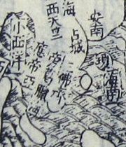
West Asia
- "Desert"
- Xifan 西番 – "Western Barbarians" (Tibetans of the KhamKhamKham , is a historical region covering a land area largely divided between present-day Tibetan Autonomous Region and Sichuan province, with smaller portions located within Qinghai, Gansu and Yunnan provinces of China. During the Republic of China's rule over mainland China , most of the region was...
region) - Huihui 回回 – Muslims
- Xiyu 西域 – “Western Regions”
- Xingsu hai 星宿海 – Qinghai LakeQinghai LakeQinghai Lake , is a saline lake situated in the province of Qinghai, and is the largest lake in China. The names Qinghai and Kokonor both mean "Blue/Teal Sea/Lake" in Chinese and Mongolian. It is located about west of the provincial capital of Xining at 3,205 m above sea level in a depression...
(alleged source of the Yellow River) - Kunlun 崑崙 – Kunlun mountainsKunlun MountainsThe Kunlun Mountains are one of the longest mountain chains in Asia, extending more than 3,000 km. In the broadest sense, it forms the northern edge of the Tibetan Plateau south of the Tarim Basin and the Gansu Corridor and continues east south of the Wei River to end at the North China Plain.The...
South Asia
- Annam 安南 – Annam (VietnamVietnamVietnam – sometimes spelled Viet Nam , officially the Socialist Republic of Vietnam – is the easternmost country on the Indochina Peninsula in Southeast Asia. It is bordered by China to the north, Laos to the northwest, Cambodia to the southwest, and the South China Sea –...
) - Chancheng 占城 – ChampaChampaThe kingdom of Champa was an Indianized kingdom that controlled what is now southern and central Vietnam from approximately the 7th century through to 1832.The Cham people are remnants...
- Hainan 海南 – HainanHainanHainan is the smallest province of the People's Republic of China . Although the province comprises some two hundred islands scattered among three archipelagos off the southern coast, of its land mass is Hainan Island , from which the province takes its name...
- Sanfoqi 三佛齊 – SrivijayaSrivijayaSrivijaya was a powerful ancient thalassocratic Malay empire based on the island of Sumatra, modern day Indonesia, which influenced much of Southeast Asia. The earliest solid proof of its existence dates from the 7th century; a Chinese monk, I-Tsing, wrote that he visited Srivijaya in 671 for 6...
- Yingdiya 應帝亞 – IndiaIndiaIndia , officially the Republic of India , is a country in South Asia. It is the seventh-largest country by geographical area, the second-most populous country with over 1.2 billion people, and the most populous democracy in the world...
- Xi Tianzhu 西天竺 – Western India
The two areas of Java
Java
Java is an island of Indonesia. With a population of 135 million , it is the world's most populous island, and one of the most densely populated regions in the world. It is home to 60% of Indonesia's population. The Indonesian capital city, Jakarta, is in west Java...
Major (Mu Zhaowa 木爪哇) and Java
Java
Java is an island of Indonesia. With a population of 135 million , it is the world's most populous island, and one of the most densely populated regions in the world. It is home to 60% of Indonesia's population. The Indonesian capital city, Jakarta, is in west Java...
Minor (Xiao Zhaowa 小爪哇) are shown far into the ocean, to the south, near the Antarctic.
Two seas are shown: the Bay of Bengal
Bay of Bengal
The Bay of Bengal , the largest bay in the world, forms the northeastern part of the Indian Ocean. It resembles a triangle in shape, and is bordered mostly by the Eastern Coast of India, southern coast of Bangladesh and Sri Lanka to the west and Burma and the Andaman and Nicobar Islands to the...
(Banggela hai 旁葛臘海, phonetically), and the Western Indian Ocean or Persian Gulf
Persian Gulf
The Persian Gulf, in Southwest Asia, is an extension of the Indian Ocean located between Iran and the Arabian Peninsula.The Persian Gulf was the focus of the 1980–1988 Iran-Iraq War, in which each side attacked the other's oil tankers...
(Xiao Xi yang 小西洋, lit. "Small Western Ocean").
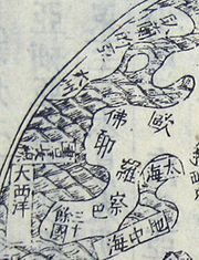
Europe
Europe
Europe is, by convention, one of the world's seven continents. Comprising the westernmost peninsula of Eurasia, Europe is generally 'divided' from Asia to its east by the watershed divides of the Ural and Caucasus Mountains, the Ural River, the Caspian and Black Seas, and the waterways connecting...
is depicted as the landmass at the westernmost part of the Eurasian landmass. It is marked phonetically "Ouluoba" (歐羅巴). Only France
France
The French Republic , The French Republic , The French Republic , (commonly known as France , is a unitary semi-presidential republic in Western Europe with several overseas territories and islands located on other continents and in the Indian, Pacific, and Atlantic oceans. Metropolitan France...
is named as a country , while others are marked as "more than thirty countries" . Greenland
Greenland
Greenland is an autonomous country within the Kingdom of Denmark, located between the Arctic and Atlantic Oceans, east of the Canadian Arctic Archipelago. Though physiographically a part of the continent of North America, Greenland has been politically and culturally associated with Europe for...
is identified as well .
On the map, Europe is surrounded by the Atlantic (大西洋, "Great Western Ocean", still the modern name for the Atlantic) to the West, the Mediterranean (地中海, "Sea in the middle of the land", still the modern name for the Mediterranean) to the South, and the Black Sea
Black Sea
The Black Sea is bounded by Europe, Anatolia and the Caucasus and is ultimately connected to the Atlantic Ocean via the Mediterranean and the Aegean seas and various straits. The Bosphorus strait connects it to the Sea of Marmara, and the strait of the Dardanelles connects that sea to the Aegean...
(Tai hai, 太海) to the East.
North America
North AmericaNorth America
North America is a continent wholly within the Northern Hemisphere and almost wholly within the Western Hemisphere. It is also considered a northern subcontinent of the Americas...
is described phonetically as North Ya-Mo-Li-Ja (Bei Yamolijia 北亞墨利加). A few locations are mentioned but remain unidentified:
- Hanhe 寒河 – "Cold river" not identified
- Xiangfeng 香峯 – "Fragrant peak" not identified
- Yawaima 亞外馬 – not identified
South America
South AmericaSouth America
South America is a continent situated in the Western Hemisphere, mostly in the Southern Hemisphere, with a relatively small portion in the Northern Hemisphere. The continent is also considered a subcontinent of the Americas. It is bordered on the west by the Pacific Ocean and on the north and east...
is described phonetically as South Ya-Mo-Li-Ja (Nan Yamolija 南亞墨利加).
- Shiren guo 食人國 – “Land of Cannibals” (BrazilBrazilBrazil , officially the Federative Republic of Brazil , is the largest country in South America. It is the world's fifth largest country, both by geographical area and by population with over 192 million people...
)
Africa
Africa
Africa is the world's second largest and second most populous continent, after Asia. At about 30.2 million km² including adjacent islands, it covers 6% of the Earth's total surface area and 20.4% of the total land area...
is described phonetically as Libya
Libya
Libya is an African country in the Maghreb region of North Africa bordered by the Mediterranean Sea to the north, Egypt to the east, Sudan to the southeast, Chad and Niger to the south, and Algeria and Tunisia to the west....
(Liweiya 利未亞). The single mention of the African continent is that of the Atlas Mountains
Atlas Mountains
The Atlas Mountains is a mountain range across a northern stretch of Africa extending about through Morocco, Algeria, and Tunisia. The highest peak is Toubkal, with an elevation of in southwestern Morocco. The Atlas ranges separate the Mediterranean and Atlantic coastlines from the Sahara Desert...
(tianxia ci shan zhigao 天下此山至高 – "the greatest mountain of the world"). The African continent is surrounded by various seas, from North, clockwise:
- Dizhong hai 地中海, lit. "Sea in the middle of land", the Mediterranean
- Xiao Xi yang 小西洋, lit. "Small Western Ocean", the Indian OceanIndian OceanThe Indian Ocean is the third largest of the world's oceanic divisions, covering approximately 20% of the water on the Earth's surface. It is bounded on the north by the Indian Subcontinent and Arabian Peninsula ; on the west by eastern Africa; on the east by Indochina, the Sunda Islands, and...
or Persian GulfPersian GulfThe Persian Gulf, in Southwest Asia, is an extension of the Indian Ocean located between Iran and the Arabian Peninsula.The Persian Gulf was the focus of the 1980–1988 Iran-Iraq War, in which each side attacked the other's oil tankers... - Xi Hong hai 西紅海, lit. "Western Red Sea", the Red SeaRed SeaThe Red Sea is a seawater inlet of the Indian Ocean, lying between Africa and Asia. The connection to the ocean is in the south through the Bab el Mandeb strait and the Gulf of Aden. In the north, there is the Sinai Peninsula, the Gulf of Aqaba, and the Gulf of Suez...
- Yalapi hai 亞蠟皮海, phonetically, the Arabian SeaArabian SeaThe Arabian Sea is a region of the Indian Ocean bounded on the east by India, on the north by Pakistan and Iran, on the west by the Arabian Peninsula, on the south, approximately, by a line between Cape Guardafui in northeastern Somalia and Kanyakumari in India...
- Liweiya hai 利未亞海, lit. "Sea of Libya", phonetically, the Gulf of GuineaGulf of GuineaThe Gulf of Guinea is the northeasternmost part of the tropical Atlantic Ocean between Cape Lopez in Gabon, north and west to Cape Palmas in Liberia. The intersection of the Equator and Prime Meridian is in the gulf....
Terra Australis
Terra AustralisTerra Australis
Terra Australis, Terra Australis Ignota or Terra Australis Incognita was a hypothesized continent appearing on European maps from the 15th to the 18th century...
is described phonetically as "Magellania" (Mowalanijia 墨瓦臘泥加), a name given to the continent at the time in honour of Magellan
Ferdinand Magellan
Ferdinand Magellan was a Portuguese explorer. He was born in Sabrosa, in northern Portugal, and served King Charles I of Spain in search of a westward route to the "Spice Islands" ....
. The map mentions how little is known about this continent: "Few have reached these southern regions, [therefore] the things [related to them] are not explored yet" (ci nanfang di ren zhi zhe shao, wei shen qi wu 此南方地人至者少, 未審其物).
- Yingge di 鸚哥地 – "Parrot Country" (Terra Psittacorum - Australia)
- Xin Runi 新入匿 – New GuineaNew GuineaNew Guinea is the world's second largest island, after Greenland, covering a land area of 786,000 km2. Located in the southwest Pacific Ocean, it lies geographically to the east of the Malay Archipelago, with which it is sometimes included as part of a greater Indo-Australian Archipelago...
- Huodi 火地 – Tierra del FuegoTierra del FuegoTierra del Fuego is an archipelago off the southernmost tip of the South American mainland, across the Strait of Magellan. The archipelago consists of a main island Isla Grande de Tierra del Fuego divided between Chile and Argentina with an area of , and a group of smaller islands including Cape...
- Baifeng 白峯 – "White Peak" not identified
- Dajiang 大江 – "Great Bay" not identified