

Little Sandy River (Oregon)
Encyclopedia
The Little Sandy River is a tributary, roughly 15 miles (24.1 km) long, of the Bull Run River
in the U.S. state
of Oregon
. Forming west of Mount Hood
in the Mount Hood National Forest
, it flows generally west, roughly parallel to the Sandy River
to the south. Its entire course lies in Clackamas County
, and most of its main stem and tributaries are within the Bull Run Watershed Management Unit (BRWMU), a restricted zone that protects Portland
's main water supply.
In 2008, Portland General Electric
(PGE) removed the Little Sandy Dam, the only dam on the river, while decommissioning its Bull Run Hydroelectric Project
. This made possible, for the first time in nearly a century, the return of migratory salmon
and steelhead
to the river. In 2009, both types of fish were reported spawning above the former dam site.
(USGS) stream gauge
at river mile
(RM) 1.95 or river kilometer (RK) 3.14, a ridge, the Devil's Backbone, separates the Little Sandy from the Sandy River to the south. Just below the stream gauge, the Little Sandy passes the former Little Sandy Dam. The river enters the Bull Run River about 2 miles (3.2 km) from the larger stream's confluence with the Sandy River. Falling 2934 feet (894.3 m) between source and mouth, the river's average loss of elevation is about 196 ft/mi.
Most of the course of the river lies within the BRWMU, a federally protected area of 143 mi2 surrounding the main drinking water supply for Portland. Access to the BRWMU is generally limited to government employees and guests on official business, and security guards keep watch on its three gated entrances. In 1996, the U.S. Congress
banned commercial logging
on all federal lands in the Bull Run River watershed and, through the Little Sandy Act of 2001, extended the ban to include all federal lands draining into the Little Sandy River and the lower Bull Run River.
1.95 miles (3.1 km) from the mouth of the river. The average flow at this gauge over the 89 years from 1920 to 2008 was 143 cuft/s. This was from a drainage area of 22.3 square miles (58 km²). The maximum flow recorded there was 5320 cuft/s on November 20, 1921, and the minimum flow was 8 cuft/s on August 20 and September 16 and 17, 1940.
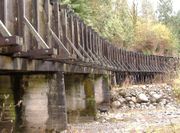 From 1912 through 2008, the river's flow was altered by the Bull Run Hydroelectric Project, which diverted water from the Sandy River at the Marmot Dam to the Little Sandy River at the Little Sandy Dam. Water was then diverted from the Little Sandy River to Roslyn Lake through a wood box flume
. The artificial lake supplied the 22-megawatt Bull Run hydroelectric powerhouse and emptied into the Bull Run River.
Engineers demolished the 47 feet (14.3 m) high Marmot Dam for PGE in July 2007 and the 16 feet (4.9 m) high Little Sandy Dam in 2008, and Roslyn Lake ceased to exist. The decommissioning restored the Little Sandy River to steelhead and salmon runs for the first time in nearly a century. PGE, the dams' owner, donated 1500 acres (6.1 km²) of land near the dams to the Western Rivers Conservancy for a nature reserve and recreation area. In May 2009, a fish biologist reported that salmon and steelhead were spawning upstream of the former dam.
Bull Run River (Oregon)
The Bull Run River is a tributary of the Sandy River in the U.S. state of Oregon. Beginning at the lower end of Bull Run Lake in the Cascade Range, it flows generally west through the Bull Run Watershed Management Unit , a restricted area meant to protect the river and its tributaries from...
in the U.S. state
U.S. state
A U.S. state is any one of the 50 federated states of the United States of America that share sovereignty with the federal government. Because of this shared sovereignty, an American is a citizen both of the federal entity and of his or her state of domicile. Four states use the official title of...
of Oregon
Oregon
Oregon is a state in the Pacific Northwest region of the United States. It is located on the Pacific coast, with Washington to the north, California to the south, Nevada on the southeast and Idaho to the east. The Columbia and Snake rivers delineate much of Oregon's northern and eastern...
. Forming west of Mount Hood
Mount Hood
Mount Hood, called Wy'east by the Multnomah tribe, is a stratovolcano in the Cascade Volcanic Arc of northern Oregon. It was formed by a subduction zone and rests in the Pacific Northwest region of the United States...
in the Mount Hood National Forest
Mount Hood National Forest
The Mount Hood National Forest is located east of the city of Portland, Oregon, and the northern Willamette River valley. The Forest extends south from the Columbia River Gorge across more than of forested mountains, lakes and streams to the Olallie Scenic Area, a high lake basin under the slopes...
, it flows generally west, roughly parallel to the Sandy River
Sandy River (Oregon)
The Sandy River is a tributary of the Columbia River in northwestern Oregon in the United States. Measured by a United States Geological Survey gauge downstream of the Sandy's confluence with the Bull Run River, from the mouth, the river's average discharge is . The maximum daily recorded flow...
to the south. Its entire course lies in Clackamas County
Clackamas County, Oregon
Clackamas County is a county located in the U.S. state of Oregon. The county was named after the Native Americans living in the area, the Clackamas Indians, who were part of the Chinookan people. As of 2010, the population was 375,992...
, and most of its main stem and tributaries are within the Bull Run Watershed Management Unit (BRWMU), a restricted zone that protects Portland
Portland, Oregon
Portland is a city located in the Pacific Northwest, near the confluence of the Willamette and Columbia rivers in the U.S. state of Oregon. As of the 2010 Census, it had a population of 583,776, making it the 29th most populous city in the United States...
's main water supply.
In 2008, Portland General Electric
Portland General Electric
Portland General Electric is an electrical utility based in Portland in the U.S. state of Oregon. It distributes electricity to customers in parts of Multnomah, Clackamas, Marion, Yamhill, Washington, and Polk counties - half of the inhabitants of Oregon...
(PGE) removed the Little Sandy Dam, the only dam on the river, while decommissioning its Bull Run Hydroelectric Project
Bull Run Hydroelectric Project
The Bull Run Hydroelectric Project was a Portland General Electric development in the Sandy River basin in the U.S. state of Oregon. Originally built between 1908 and 1912 near the town of Bull Run, it supplied hydroelectric power for the Portland area for nearly a century, until it was removed in...
. This made possible, for the first time in nearly a century, the return of migratory salmon
Salmon
Salmon is the common name for several species of fish in the family Salmonidae. Several other fish in the same family are called trout; the difference is often said to be that salmon migrate and trout are resident, but this distinction does not strictly hold true...
and steelhead
Rainbow trout
The rainbow trout is a species of salmonid native to tributaries of the Pacific Ocean in Asia and North America. The steelhead is a sea run rainbow trout usually returning to freshwater to spawn after 2 to 3 years at sea. In other words, rainbow trout and steelhead trout are the same species....
to the river. In 2009, both types of fish were reported spawning above the former dam site.
Course
Arising southeast of Hickman Butte in the Mount Hood National Forest, the river flows northwest between North Mountain on the left and Goodfellow Lakes on the right. Turning west, it passes south of Aschoff Buttes before receiving its only named tributaries, Bow Creek and Arrow Creek, both from the right. As the river nears a United States Geological SurveyUnited States Geological Survey
The United States Geological Survey is a scientific agency of the United States government. The scientists of the USGS study the landscape of the United States, its natural resources, and the natural hazards that threaten it. The organization has four major science disciplines, concerning biology,...
(USGS) stream gauge
Stream gauge
A stream gauge, stream gage or gauging station is a location used by hydrologists or environmental scientists to monitor and test terrestrial bodies of water. Hydrometric measurements of water surface elevation and/or volumetric discharge are generally taken and observations of biota may also be...
at river mile
River mile
In the United States, a River mile is a measure of distance in miles along a river from its mouth. River mile numbers begin at zero and increase further upstream. The corresponding metric unit using kilometers is the River kilometer...
(RM) 1.95 or river kilometer (RK) 3.14, a ridge, the Devil's Backbone, separates the Little Sandy from the Sandy River to the south. Just below the stream gauge, the Little Sandy passes the former Little Sandy Dam. The river enters the Bull Run River about 2 miles (3.2 km) from the larger stream's confluence with the Sandy River. Falling 2934 feet (894.3 m) between source and mouth, the river's average loss of elevation is about 196 ft/mi.
Most of the course of the river lies within the BRWMU, a federally protected area of 143 mi2 surrounding the main drinking water supply for Portland. Access to the BRWMU is generally limited to government employees and guests on official business, and security guards keep watch on its three gated entrances. In 1996, the U.S. Congress
United States Congress
The United States Congress is the bicameral legislature of the federal government of the United States, consisting of the Senate and the House of Representatives. The Congress meets in the United States Capitol in Washington, D.C....
banned commercial logging
Logging
Logging is the cutting, skidding, on-site processing, and loading of trees or logs onto trucks.In forestry, the term logging is sometimes used in a narrow sense concerning the logistics of moving wood from the stump to somewhere outside the forest, usually a sawmill or a lumber yard...
on all federal lands in the Bull Run River watershed and, through the Little Sandy Act of 2001, extended the ban to include all federal lands draining into the Little Sandy River and the lower Bull Run River.
Discharge
The USGS monitors the flow of the Little Sandy River at a stream gaugeStream gauge
A stream gauge, stream gage or gauging station is a location used by hydrologists or environmental scientists to monitor and test terrestrial bodies of water. Hydrometric measurements of water surface elevation and/or volumetric discharge are generally taken and observations of biota may also be...
1.95 miles (3.1 km) from the mouth of the river. The average flow at this gauge over the 89 years from 1920 to 2008 was 143 cuft/s. This was from a drainage area of 22.3 square miles (58 km²). The maximum flow recorded there was 5320 cuft/s on November 20, 1921, and the minimum flow was 8 cuft/s on August 20 and September 16 and 17, 1940.
Little Sandy Dam
Flume
A flume is an open artificial water channel, in the form of a gravity chute, that leads water from a diversion dam or weir completely aside a natural flow. Often, the flume is an elevated box structure that follows the natural contours of the land. These have been extensively used in hydraulic...
. The artificial lake supplied the 22-megawatt Bull Run hydroelectric powerhouse and emptied into the Bull Run River.
Engineers demolished the 47 feet (14.3 m) high Marmot Dam for PGE in July 2007 and the 16 feet (4.9 m) high Little Sandy Dam in 2008, and Roslyn Lake ceased to exist. The decommissioning restored the Little Sandy River to steelhead and salmon runs for the first time in nearly a century. PGE, the dams' owner, donated 1500 acres (6.1 km²) of land near the dams to the Western Rivers Conservancy for a nature reserve and recreation area. In May 2009, a fish biologist reported that salmon and steelhead were spawning upstream of the former dam.