
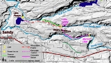
Bull Run Hydroelectric Project
Encyclopedia
Portland General Electric
Portland General Electric is an electrical utility based in Portland in the U.S. state of Oregon. It distributes electricity to customers in parts of Multnomah, Clackamas, Marion, Yamhill, Washington, and Polk counties - half of the inhabitants of Oregon...
(PGE) development in the Sandy River
Sandy River (Oregon)
The Sandy River is a tributary of the Columbia River in northwestern Oregon in the United States. Measured by a United States Geological Survey gauge downstream of the Sandy's confluence with the Bull Run River, from the mouth, the river's average discharge is . The maximum daily recorded flow...
basin in the U.S. state of Oregon
Oregon
Oregon is a state in the Pacific Northwest region of the United States. It is located on the Pacific coast, with Washington to the north, California to the south, Nevada on the southeast and Idaho to the east. The Columbia and Snake rivers delineate much of Oregon's northern and eastern...
. Originally built between 1908 and 1912 near the town of Bull Run
Bull Run, Oregon
Bull Run is an unincorporated community in Clackamas County, Oregon, United States, about northeast of Sandy near the Bull Run River.The first post office in the locale was "Unavilla", established in 1893. The name was changed to "Bullrun" in 1895, and to Camp Namanu in 1939. The post office was...
, it supplied hydroelectric
Hydroelectricity
Hydroelectricity is the term referring to electricity generated by hydropower; the production of electrical power through the use of the gravitational force of falling or flowing water. It is the most widely used form of renewable energy...
power for the Portland
Portland, Oregon
Portland is a city located in the Pacific Northwest, near the confluence of the Willamette and Columbia rivers in the U.S. state of Oregon. As of the 2010 Census, it had a population of 583,776, making it the 29th most populous city in the United States...
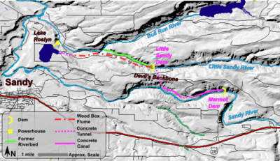
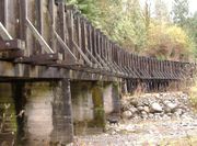
area for nearly a century, until it was removed in 2007 and 2008. The project used a system of canals, tunnels, wood box flume
Flume
A flume is an open artificial water channel, in the form of a gravity chute, that leads water from a diversion dam or weir completely aside a natural flow. Often, the flume is an elevated box structure that follows the natural contours of the land. These have been extensively used in hydraulic...
s and diversion dam
Diversion dam
A diversion dam is the term for a dam that diverts all or a portion of the flow of a river from its natural course. Diversion dams do not generally impound water in a reservoir...
s to feed a remote storage reservoir and powerhouse. The entire project was removed because of rising environmental costs. Marmot Dam on the Sandy River was demolished in 2007, and the Little Sandy Dam on the Little Sandy River
Little Sandy River (Oregon)
The Little Sandy River is a tributary, roughly long, of the Bull Run River in the U.S. state of Oregon. Forming west of Mount Hood in the Mount Hood National Forest, it flows generally west, roughly parallel to the Sandy River to the south...
was taken down in 2008.
History and overview
Mount Hood Railway and Power Company
The Mount Hood Railway and Power Company, also known as the Mount Hood Company, initiated hydroelectric development in the Sandy River basin in the U.S. state of Oregon in 1906. Its Bull Run Hydroelectric Project included a powerhouse on the Bull Run River, a tributary of the Sandy River, and a...
(MHR&P), also known as the Mount Hood Company, began the project in 1906, building the Little Sandy Dam to divert water through a wooden flume
Flume
A flume is an open artificial water channel, in the form of a gravity chute, that leads water from a diversion dam or weir completely aside a natural flow. Often, the flume is an elevated box structure that follows the natural contours of the land. These have been extensively used in hydraulic...
, about 3.2 miles (5.1 km) long, to Roslyn Lake. The dam reduced streamflows on the lower 1.7 miles (2.7 km) of the Little Sandy River
Little Sandy River (Oregon)
The Little Sandy River is a tributary, roughly long, of the Bull Run River in the U.S. state of Oregon. Forming west of Mount Hood in the Mount Hood National Forest, it flows generally west, roughly parallel to the Sandy River to the south...
and blocked all salmon
Salmon
Salmon is the common name for several species of fish in the family Salmonidae. Several other fish in the same family are called trout; the difference is often said to be that salmon migrate and trout are resident, but this distinction does not strictly hold true...
and steelhead access to the upper 6.5 miles (10.5 km) of the river. Roslyn Lake was at 656 feet (199.9 m) above sea level, about 400 feet (121.9 m) higher than the mouth of the Bull Run River
Bull Run River (Oregon)
The Bull Run River is a tributary of the Sandy River in the U.S. state of Oregon. Beginning at the lower end of Bull Run Lake in the Cascade Range, it flows generally west through the Bull Run Watershed Management Unit , a restricted area meant to protect the river and its tributaries from...
, at 242 feet (73.8 m). The 140 acre (0.5665604 km²) lake acted as a reservoir for the powerhouse, which was completed and put into operation in 1912, the same year that the MHR&P merged with Portland Railway, Light and Power Company
Portland Railway, Light and Power Company
The Portland Railway, Light and Power Company was a railway company and electric power utility in Portland, Oregon, United States, from 1906 until 1924....
(PRL&P), the predecessor of PGE.
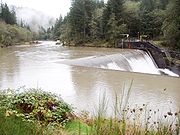
In 1913 PRL&P built a dam on the Sandy River
Sandy River (Oregon)
The Sandy River is a tributary of the Columbia River in northwestern Oregon in the United States. Measured by a United States Geological Survey gauge downstream of the Sandy's confluence with the Bull Run River, from the mouth, the river's average discharge is . The maximum daily recorded flow...
to supplement the Little Sandy Dam. The Marmot Dam, 30 feet (9.1 m) high, diverted water from the Sandy to the Little Sandy by canal and tunnel, the longest of which ran 4690 feet (1,429.5 m) under the ridge between the two rivers. The new dam supplied up to 600 cuft/s to the Little Sandy above its diversion dam, and the Little Sandy provided up to 200 cuft/s, all of which could be diverted through the flume to Roslyn Lake.
The Marmot Dam included a fish ladder
Fish ladder
A fish ladder, also known as a fishway, fish pass or fish steps, is a structure on or around artificial barriers to facilitate diadromous fishes' natural migration. Most fishways enable fish to pass around the barriers by swimming and leaping up a series of relatively low steps into the waters on...
to allow migration of salmon
Salmon
Salmon is the common name for several species of fish in the family Salmonidae. Several other fish in the same family are called trout; the difference is often said to be that salmon migrate and trout are resident, but this distinction does not strictly hold true...
and steelhead; however it performed poorly at first and required frequent upgrades and maintenance, which continued into the 1990s. To prevent fish from being swept into the diversion canal, PGE installed fish screens in 1951 and later added a bypass system to rescue fish trapped in the canal..
In 1989 the original timber crib Marmot Dam was replaced with a concrete structure.
Operations
| Feature | Location |
|---|---|
| Marmot Dam | 45.39969°N 122.13233°W |
| Little Sandy Dam | 45.41492°N 122.17757°W |
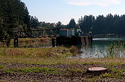
| Bull Run Hydro powerhouse | 45.42901°N 122.23395°W |
Watt
The watt is a derived unit of power in the International System of Units , named after the Scottish engineer James Watt . The unit, defined as one joule per second, measures the rate of energy conversion.-Definition:...
s (MW), enough to power 12,000 homes in 2007.
Facts
| Generating capacity | 22 MW |
| FERC license | No. 477 |
| Average power generation | 13 MW |
| Average annual power generation | 110,000 MW·h (400 TJ) |
| Electrical power value at $0.06/kW·h | $6,600,000 |
| Sandy River water supply | 600 ft³/s (17 m³/s) (max) |
| Little Sandy River water supply | 100% |
| Flume capacity | 900 ft³/s (25 m³/s) (in any combination of Sandy or Little Sandy water) |
| Lake surface area | 160 acres (650,000 m²) |
| Usable storage capacity | 928 acre.ft |
| Penstocks | 2 by 1200 ft (0.6096 by 365.8 m), 9 ft (2.7 m) diameter |
| Hydraulic head | 320 ft (98 m or 960 kPa KPA KPA may refer to:* Kenya Ports Authority* Kiln phosphoric acid, a dry process to produce phosphoric acid at high temperature in a kiln* Kilopascal , a unit of pressure* Known-plaintext attack, a method of cryptanalysis* Korean People's Army... ) |
| Turbines | 4 |
Decommissioning
The decommissioning project required significant oversight, because Marmot Dam was the largest concrete dam ever removed in the United States. PGE sought and received initial approval for the project from the Federal Energy Regulatory CommissionFederal Energy Regulatory Commission
The Federal Energy Regulatory Commission is the United States federal agency with jurisdiction over interstate electricity sales, wholesale electric rates, hydroelectric licensing, natural gas pricing, and oil pipeline rates...
(FERC) in 1999. PGE later employed RESOLVE
RESOLVE
RESOLVE is a Washington, D.C. based non-profit group dedicated to dispute resolution of public policy related topics. They will help interested parties reach consensus on difficult issues in a results oriented process....
, a non-profit dispute resolution organization, to help develop a detailed consensus plan among the interested parties. An agreement was reached in 2002 on the decommissioning. The primary issues addressed by the reviews were the impact on fish species (particularly salmonids), their habitat, and the effect of the release of 1 million cubic yards (750,000 cubic meters) of sediment on the river course. In 2004, PGE allowed its operating license to lapse, and filed a notice stating: "[...]the likely cost of providing the necessary level of protection, mitigation, and enhancement for the resources affected by the Project would outweigh the economic benefit of generation at the Project over the life of a new license[...]" The project continued to operate with license extensions while decommissioning awaited approval. In 2006, PGE requested special approval of the decommissioning from the National Marine Fisheries Service
National Marine Fisheries Service
The National Marine Fisheries Service is a United States federal agency. A division of the National Oceanic and Atmospheric Administration and the Department of Commerce, NMFS is responsible for the stewardship and management of the nation's living marine resources and their habitat within the...
, because of the project's potential impact on coho salmon
Coho salmon
The Coho salmon, Oncorhynchus kisutch, is a species of anadromous fish in the salmon family. Coho salmon are also known as silver salmon or "silvers". It is the state animal of Chiba, Japan.-Description:...
. The final review was conducted by the United States Army Corps of Engineers
United States Army Corps of Engineers
The United States Army Corps of Engineers is a federal agency and a major Army command made up of some 38,000 civilian and military personnel, making it the world's largest public engineering, design and construction management agency...
, which granted approval for the decommissioning on May 21, 2007. A spokesman for the Corps stated that the removal project was unusual, because "Large dams usually don't get removed."
Before Marmot Dam could be removed, a temporary coffer dam had to be built upstream. When this phase of the project was complete, the removal of the permanent concrete dam could proceed. The destruction of the permanent dam began on 26 July 2007, when a public controlled demolition
Controlled demolition
Controlled demolition refers to:* Demolition, the tearing-down of buildings and other structures* Controlled Demolition, Inc., Phoenix, Maryland firm that specializes in the use of explosives to create a controlled demolition of a structure...
weakened the structure. The rest of the dam was destroyed using pneumatic hammers over approximately 4 months. The last concrete from Marmot Dam was removed on September 30, 2007, and the final phase of removal was completed on 20 October 2007, when the temporary earthen dam washed away and the Sandy River
Sandy River
The Sandy River may refer to some locations in the United States:Communities*Sandy River Plantation, Maine, a municipalityRivers*Sandy River in Maine*Sandy River *Sandy River...
began to flow freely for the first time since 1912.
PGE removed Little Sandy Dam in 2008, eliminating Roslyn Lake. This restored Little Sandy River flow and made salmon and steelhead migration once again possible. In May 2009, a fish biologist reported that salmon and steelhead were spawning upstream of the former dam. PGE donated 1500 acres (6.1 km²) of the dam site to the Western Rivers Conservancy. This land is planned to form the core of a 9000 acres (36.4 km²) natural refuge and public recreation area, which will be managed by the Bureau of Land Management
Bureau of Land Management
The Bureau of Land Management is an agency within the United States Department of the Interior which administers America's public lands, totaling approximately , or one-eighth of the landmass of the country. The BLM also manages of subsurface mineral estate underlying federal, state and private...
. PGE's water rights on the river were transferred to the state. As of 2009, PGE biologists continue to monitor the streams.
As part of its decommissioning, PGE planned to demolish the powerhouse until a private company offered to buy it. Powerhouse Re Gen LLC, a group of historic preservationists, have agreed to acquire the building, which is eligible for listing on the National Register of Historic Places
National Register of Historic Places
The National Register of Historic Places is the United States government's official list of districts, sites, buildings, structures, and objects deemed worthy of preservation...
. According to the Daily Journal of Commerce of February 2, 2010, although PGE and Re Gen have agreed on the purchase, Re Gen must first seek approval from Clackamas County, complete an environmental study of the site, and seek approval from FERC. Re Gen, which has not announced specific plans for the site, plans to preserve it as well as other structures near Roslyn Lake.
Works cited
- Taylor, Barbara (1998). "Salmon and Steelhead Runs and Related Events of the Sandy River Basin – A Historical Perspective". Portland, Oregon: Portland General Electric Company. Retrieved January 16, 2010.
External links
- Settlement Agreement Concerning the Removal of the Bull Run Hydroelectric Project..., PGE and interested parties, October 24, 2002. ( 1.2MB pdf)
- Clean Water Act § 401 Certification Evaluation and Finding Report For the Decommissioning of the Bull Run Hydroelectric Project (FERC No. 477), Sandy River Basin, Clackamas County, Oregon 1.2MB pdf.
- Restoring the Sandy River Basin (American Rivers)