
Saint Croix State Park
Encyclopedia
St. Croix State Park is a state park
in Pine County, Minnesota
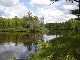
, USA. The park follows the shore of the St. Croix River
for 21 miles (33.8 km) and contains the last 7 miles (11.3 km) of the Kettle River
. At 33895 acres (13,716.8 ha) it is the largest Minnesota state park. It was developed as a Recreational Demonstration Area
in the 1930s. 164 structures built by the Civilian Conservation Corps
and the Works Progress Administration
survive, the largest collection of New Deal
projects in Minnesota. Many are listed on the National Register of Historic Places
and the entire historic district was listed as a National Historic Landmark
in 1997.
of the area is mostly buried under 75 to 100 ft (22.9 to 30.5 m) of these glacial till
deposits. However the underlying basalt
and sandstone
is exposed in one area along the Kettle River known as the Highbanks, where a final ancient flood of meltwater scoured away the sediments.
In addition to the two rivers, at least ten other streams flow through the park, creating a watershed
of hundreds of square miles.
St. Croix State Park is located on the eastern edge of the Mille Lacs Uplands. Initially dominated by red
and white pines
, the vegetation has been altered by logging and farming. The present secondary forest
is a mix of pines, black spruce
, sugar maple
, and basswood. More open areas form meadows, oak savanna
, and jack pine
barrens
. Numerous lakes, marshes, and streams support wetland
and riparian zone
plants. Wetlands with no outlet and high acidity support tamarack bog
s.
Large mammals found in the park include eastern timber wolves
, black bears
, white-tailed deer
, coyote
s, beavers
, raccoon
s, and gray
and red foxes
. Birds include the ruffed grouse
.
A tornado
hit part of the park on July 4, 1977. Straight-line winds toppled trees over hundreds of acres on July 11, 2008 and again on July 1, 2011. In the latter storm, many of the historical structures were damaged. However there were no injuries as the park was closed due to the 2011 Minnesota state government shutdown
.
people by the late 17th Century, when French traders began exploring the region. However the Dakota were soon displaced by the Ojibwe.
Fur trade
rs became more numerous, and a trading post
was established within what is now St. Croix State Park. Following an 1837 treaty with the Ojibwe the region was opened up to logging
, although harvesting in the park did not begin until later in the 19th Century. From 1894 to 1898 the Empire Lumber Company operated a rail line, the Flemming Railroad, to transport logs cut farther inland to the St. Croix River. The line ended at Yellowbanks where the logs were rolled down the steep bluffs and floated to sawmills downriver. St. John's Landing, at the northeast end of the park, is named for Ed St. John, who opened a popular boarding house
there for lumbermen.
The area was logged out by 1915 and farmers were attracted to the newly cleared land. However the sandy soil was poor and not productive enough to make a living. Most settlers moved away and much of the land was tax-forfeited. Pine County had the most tax delinquent property in Minnesota and suffered abject environmental degradation from cultivation and wildfire
s like the Great Hinckley Fire
.
In 1934 the area was selected for a Recreational Demonstration Area
, a New Deal program that provided jobs, paid farmers for poor cropland, and created outdoor recreation opportunities near urban areas (the site is midway between Minneapolis–St. Paul and Duluth
). An initial 18000 acres (7,284.3 ha) of land were transferred to the U.S. Department of the Interior
, as the National Park Service
would direct the work of the Civilian Conservation Corps
(CCC) and the Works Progress Administration
(WPA). A CCC camp was constructed at Yellowbanks, populated first by Company #2762 and later #2706. Crews built the main park road, following the old Flemming Railroad route, and another 25 miles (40.2 km) of road. Trails and scenic overlooks were established while farm buildings were demolished. From Camp Yellowbanks the crews used sandstone and lumber from within the park to develop five separate areas for visitors. First was park headquarters, second Riverview Campground and a lodge which is now the interpretive center. The other three were group centers constructed by WPA crews: Norway Point for boys, St. John's Landing for girls, and Head of the Rapids for handicapped children. Some crews planted pine, spruce, and hardwood trees to begin reforestation
while others conducted wildlife and fire protection work. A CCC crew built a fire tower in 1937. As additional properties were added, St. Croix Recreational Demonstration Area grew to 30000 acres (121.4 km²), only slightly smaller than the country's largest RDA at Custer State Park
in South Dakota.
As planned following federal development, St. Croix Recreational Demonstration Area was transferred to the state to became St. Croix State Park in 1943. The fire tower was staffed during fire season until 1981, when aerial surveys became the preferred spotting method. St. John's Landing Group Center is now a camp for the Minnesota Conservation Corps.
, bass, sauger
, and muskellunge
. Hay Creek and some of the park's other streams contain trout. Hay Creek widens into Lake Clayton, which has a swimming beach and picnic area.
A paved trail leads from Lake Clayton to the drive-in campground, which has three loops with a total of 211 sites. Elsewhere there are eight group campsites and remote campsites for backpackers and canoers. More modern accommodation is provided by two group centers, five cabins, and two guest houses.
Of the trails in the park, 127 miles (204.4 km) are open for hiking, 75 miles (120.7 km) for horseback riding, 21 miles (33.8 km) for mountain biking, 80 miles (128.7 km) for snowmobiles, and 11 miles (17.7 km) for cross-country skiing. The Willard Munger State Trail
passes through the length of the park. Visitors can climb the 134 steps to the cab of the fire tower; interpretive signs describe the layers of the forest habitat and features of the surrounding countryside.
St. Croix State Park borders Chengwatana State Forest
to the southwest and Saint Croix State Forest to the northeast. Governor Knowles State Forest
lies across the river in Wisconsin. The entire river corridor is part of the Saint Croix National Scenic Riverway
. The Kettle River is designated a State Wild and Scenic River.
State park
State parks are parks or other protected areas managed at the federated state level within those nations which use "state" as a political subdivision. State parks are typically established by a state to preserve a location on account of its natural beauty, historic interest, or recreational...
in Pine County, Minnesota
Pine County, Minnesota
As of the census of 2000, there were 26,530 people, 9,939 households, and 6,917 families residing in the county. The population density was 19 people per square mile . There were 15,353 housing units at an average density of 11 per square mile...
, USA. The park follows the shore of the St. Croix River
St. Croix River (Wisconsin-Minnesota)
The St. Croix River is a tributary of the Mississippi River, approximately long, in the U.S. states of Wisconsin and Minnesota. The lower of the river form the border between Wisconsin and Minnesota. The river is a National Scenic Riverway under the protection of the National Park Service. A...
for 21 miles (33.8 km) and contains the last 7 miles (11.3 km) of the Kettle River
Kettle River (Minnesota)
The Kettle is a tributary of the St. Croix River, about 80 mi long, in eastern Minnesota in the United States. Via the St. Croix River, it is part of the watershed of the Mississippi River. The river's English name is due to the large number of large rounded holes in the sandstone in and around...
. At 33895 acres (13,716.8 ha) it is the largest Minnesota state park. It was developed as a Recreational Demonstration Area
Recreational Demonstration Area
The Recreational Demonstration Area program was a National Park Service program during the 1930s and early 1940s that built forty-six public parks in twenty-four states on , chiefly near urban areas in the United States...
in the 1930s. 164 structures built by the Civilian Conservation Corps
Civilian Conservation Corps
The Civilian Conservation Corps was a public work relief program that operated from 1933 to 1942 in the United States for unemployed, unmarried men from relief families, ages 18–25. A part of the New Deal of President Franklin D...
and the Works Progress Administration
Works Progress Administration
The Works Progress Administration was the largest and most ambitious New Deal agency, employing millions of unskilled workers to carry out public works projects, including the construction of public buildings and roads, and operated large arts, drama, media, and literacy projects...
survive, the largest collection of New Deal
New Deal
The New Deal was a series of economic programs implemented in the United States between 1933 and 1936. They were passed by the U.S. Congress during the first term of President Franklin D. Roosevelt. The programs were Roosevelt's responses to the Great Depression, and focused on what historians call...
projects in Minnesota. Many are listed on the National Register of Historic Places
National Register of Historic Places
The National Register of Historic Places is the United States government's official list of districts, sites, buildings, structures, and objects deemed worthy of preservation...
and the entire historic district was listed as a National Historic Landmark
National Historic Landmark
A National Historic Landmark is a building, site, structure, object, or district, that is officially recognized by the United States government for its historical significance...
in 1997.
Natural history
The St. Croix River Valley was carved by meltwater during the last glacial period 10,000 years ago. The water deposited a variety of sediments, which compose over 30 different types of soil within the park. Some soils are very sandy while others are made of red or yellow clay. The historic Yellowbanks area of the park is named for its distinctive deposit of yellow clay exposed by the St. Croix River. The bedrockBedrock
In stratigraphy, bedrock is the native consolidated rock underlying the surface of a terrestrial planet, usually the Earth. Above the bedrock is usually an area of broken and weathered unconsolidated rock in the basal subsoil...
of the area is mostly buried under 75 to 100 ft (22.9 to 30.5 m) of these glacial till
Till
thumb|right|Closeup of glacial till. Note that the larger grains in the till are completely surrounded by the matrix of finer material , and this characteristic, known as matrix support, is diagnostic of till....
deposits. However the underlying basalt
Basalt
Basalt is a common extrusive volcanic rock. It is usually grey to black and fine-grained due to rapid cooling of lava at the surface of a planet. It may be porphyritic containing larger crystals in a fine matrix, or vesicular, or frothy scoria. Unweathered basalt is black or grey...
and sandstone
Sandstone
Sandstone is a sedimentary rock composed mainly of sand-sized minerals or rock grains.Most sandstone is composed of quartz and/or feldspar because these are the most common minerals in the Earth's crust. Like sand, sandstone may be any colour, but the most common colours are tan, brown, yellow,...
is exposed in one area along the Kettle River known as the Highbanks, where a final ancient flood of meltwater scoured away the sediments.
In addition to the two rivers, at least ten other streams flow through the park, creating a watershed
Drainage basin
A drainage basin is an extent or an area of land where surface water from rain and melting snow or ice converges to a single point, usually the exit of the basin, where the waters join another waterbody, such as a river, lake, reservoir, estuary, wetland, sea, or ocean...
of hundreds of square miles.
St. Croix State Park is located on the eastern edge of the Mille Lacs Uplands. Initially dominated by red
Red Pine
Pinus resinosa, commonly known as the red pine or Norway pine, is pine native to North America. The Red Pine occurs from Newfoundland west to Manitoba, and south to Pennsylvania, with several smaller, disjunct populations occurring in the Appalachian Mountains in Virginia and West Virginia, as well...
and white pines
Eastern White Pine
Pinus strobus, commonly known as the eastern white pine, is a large pine native to eastern North America, occurring from Newfoundland west to Minnesota and southeastern Manitoba, and south along the Appalachian Mountains to the northern edge of Georgia.It is occasionally known as simply white pine,...
, the vegetation has been altered by logging and farming. The present secondary forest
Secondary forest
A secondary forest is a forest or woodland area which has re-grown after a major disturbance such as fire, insect infestation, timber harvest or windthrow, until a long enough period has passed so that the effects of the disturbance are no longer evident...
is a mix of pines, black spruce
Black Spruce
Picea mariana is a species of spruce native to northern North America, from Newfoundland west to Alaska, and south to northern New York, Minnesota and central British Columbia...
, sugar maple
Sugar Maple
Acer saccharum is a species of maple native to the hardwood forests of northeastern North America, from Nova Scotia west to southern Ontario, and south to Georgia and Texas...
, and basswood. More open areas form meadows, oak savanna
Oak savanna
An oak savanna is a type of savanna, or lightly forested grassland, where oaks are the dominant tree species. These savannas were maintained historically through wildfires set by lightning, grazing, low precipitation, poor soil, and/or fires set by Native Americans...
, and jack pine
Jack Pine
Jack pine is a North American pine with its native range in Canada east of the Rocky Mountains from Northwest Territories to Nova Scotia, and the northeast of the United States from Minnesota to Maine, with the southernmost part of the range just into northwest Indiana...
barrens
Pine barrens
Pine barrens, pine plains, sand plains, or pinelands occur throughout the northeastern U.S. from New Jersey to Maine as well as the Midwest and Canada....
. Numerous lakes, marshes, and streams support wetland
Wetland
A wetland is an area of land whose soil is saturated with water either permanently or seasonally. Wetlands are categorised by their characteristic vegetation, which is adapted to these unique soil conditions....
and riparian zone
Riparian zone
A riparian zone or riparian area is the interface between land and a river or stream. Riparian is also the proper nomenclature for one of the fifteen terrestrial biomes of the earth. Plant habitats and communities along the river margins and banks are called riparian vegetation, characterized by...
plants. Wetlands with no outlet and high acidity support tamarack bog
Bog
A bog, quagmire or mire is a wetland that accumulates acidic peat, a deposit of dead plant material—often mosses or, in Arctic climates, lichens....
s.
Large mammals found in the park include eastern timber wolves
Eastern Wolf
The Eastern Wolf , also known as Eastern Canadian Wolf or Eastern Canadian Red Wolf, may be a subspecies of gray wolf or a distinct species of canid native to the eastern part of North America since the Pleistocene era. It seems to be closely related to the Red Wolf...
, black bears
American black bear
The American black bear is a medium-sized bear native to North America. It is the continent's smallest and most common bear species. Black bears are omnivores, with their diets varying greatly depending on season and location. They typically live in largely forested areas, but do leave forests in...
, white-tailed deer
White-tailed Deer
The white-tailed deer , also known as the Virginia deer or simply as the whitetail, is a medium-sized deer native to the United States , Canada, Mexico, Central America, and South America as far south as Peru...
, coyote
Coyote
The coyote , also known as the American jackal or the prairie wolf, is a species of canine found throughout North and Central America, ranging from Panama in the south, north through Mexico, the United States and Canada...
s, beavers
American Beaver
The North American Beaver is the only species of beaver in the Americas, native to North America and introduced to South America. In the United States and Canada, where no other species of beaver occurs, it is usually simply referred to as "beaver"...
, raccoon
Raccoon
Procyon is a genus of nocturnal mammals, comprising three species commonly known as raccoons, in the family Procyonidae. The most familiar species, the common raccoon , is often known simply as "the" raccoon, as the two other raccoon species in the genus are native only to the tropics and are...
s, and gray
Gray Fox
The gray fox is a mammal of the order Carnivora ranging throughout most of the southern half of North America from southern Canada to the northern part of South America...
and red foxes
Red Fox
The red fox is the largest of the true foxes, as well as being the most geographically spread member of the Carnivora, being distributed across the entire northern hemisphere from the Arctic Circle to North Africa, Central America, and the steppes of Asia...
. Birds include the ruffed grouse
Ruffed Grouse
The Ruffed Grouse is a medium-sized grouse occurring in forests from the Appalachian Mountains across Canada to Alaska. It is non-migratory.The Ruffed Grouse is frequently referred to as a "partridge"...
.
A tornado
Tornado
A tornado is a violent, dangerous, rotating column of air that is in contact with both the surface of the earth and a cumulonimbus cloud or, in rare cases, the base of a cumulus cloud. They are often referred to as a twister or a cyclone, although the word cyclone is used in meteorology in a wider...
hit part of the park on July 4, 1977. Straight-line winds toppled trees over hundreds of acres on July 11, 2008 and again on July 1, 2011. In the latter storm, many of the historical structures were damaged. However there were no injuries as the park was closed due to the 2011 Minnesota state government shutdown
2011 Minnesota state government shutdown
The 2011 Minnesota state government shutdown was a government shutdown affecting the U.S. state of Minnesota, due to a fiscal dispute between the Governor and the state legislature. The shutdown started at midnight, July 1, 2011...
.
Cultural history
Evidence of Native American occupation in the park and the St. Croix River Valley has been found dating back 5,000 years. The region was inhabited by the DakotaSioux
The Sioux are Native American and First Nations people in North America. The term can refer to any ethnic group within the Great Sioux Nation or any of the nation's many language dialects...
people by the late 17th Century, when French traders began exploring the region. However the Dakota were soon displaced by the Ojibwe.
Fur trade
Fur trade
The fur trade is a worldwide industry dealing in the acquisition and sale of animal fur. Since the establishment of world market for in the early modern period furs of boreal, polar and cold temperate mammalian animals have been the most valued...
rs became more numerous, and a trading post
Trading post
A trading post was a place or establishment in historic Northern America where the trading of goods took place. The preferred travel route to a trading post or between trading posts, was known as a trade route....
was established within what is now St. Croix State Park. Following an 1837 treaty with the Ojibwe the region was opened up to logging
Logging
Logging is the cutting, skidding, on-site processing, and loading of trees or logs onto trucks.In forestry, the term logging is sometimes used in a narrow sense concerning the logistics of moving wood from the stump to somewhere outside the forest, usually a sawmill or a lumber yard...
, although harvesting in the park did not begin until later in the 19th Century. From 1894 to 1898 the Empire Lumber Company operated a rail line, the Flemming Railroad, to transport logs cut farther inland to the St. Croix River. The line ended at Yellowbanks where the logs were rolled down the steep bluffs and floated to sawmills downriver. St. John's Landing, at the northeast end of the park, is named for Ed St. John, who opened a popular boarding house
Boarding house
A boarding house, is a house in which lodgers rent one or more rooms for one or more nights, and sometimes for extended periods of weeks, months and years. The common parts of the house are maintained, and some services, such as laundry and cleaning, may be supplied. They normally provide "bed...
there for lumbermen.
The area was logged out by 1915 and farmers were attracted to the newly cleared land. However the sandy soil was poor and not productive enough to make a living. Most settlers moved away and much of the land was tax-forfeited. Pine County had the most tax delinquent property in Minnesota and suffered abject environmental degradation from cultivation and wildfire
Wildfire
A wildfire is any uncontrolled fire in combustible vegetation that occurs in the countryside or a wilderness area. Other names such as brush fire, bushfire, forest fire, desert fire, grass fire, hill fire, squirrel fire, vegetation fire, veldfire, and wilkjjofire may be used to describe the same...
s like the Great Hinckley Fire
Great Hinckley Fire
The Great Hinckley Fire was a major conflagration on September 1, 1894, which burned an area of at least 810 km² , perhaps more than 1000 km², including the town of Hinckley, Minnesota. The fire killed hundreds, with the minimum number estimated at 418. However, some scholars believe the...
.
In 1934 the area was selected for a Recreational Demonstration Area
Recreational Demonstration Area
The Recreational Demonstration Area program was a National Park Service program during the 1930s and early 1940s that built forty-six public parks in twenty-four states on , chiefly near urban areas in the United States...
, a New Deal program that provided jobs, paid farmers for poor cropland, and created outdoor recreation opportunities near urban areas (the site is midway between Minneapolis–St. Paul and Duluth
Duluth, Minnesota
Duluth is a port city in the U.S. state of Minnesota and is the county seat of Saint Louis County. The fourth largest city in Minnesota, Duluth had a total population of 86,265 in the 2010 census. Duluth is also the second largest city that is located on Lake Superior after Thunder Bay, Ontario,...
). An initial 18000 acres (7,284.3 ha) of land were transferred to the U.S. Department of the Interior
United States Department of the Interior
The United States Department of the Interior is the United States federal executive department of the U.S. government responsible for the management and conservation of most federal land and natural resources, and the administration of programs relating to Native Americans, Alaska Natives, Native...
, as the National Park Service
National Park Service
The National Park Service is the U.S. federal agency that manages all national parks, many national monuments, and other conservation and historical properties with various title designations...
would direct the work of the Civilian Conservation Corps
Civilian Conservation Corps
The Civilian Conservation Corps was a public work relief program that operated from 1933 to 1942 in the United States for unemployed, unmarried men from relief families, ages 18–25. A part of the New Deal of President Franklin D...
(CCC) and the Works Progress Administration
Works Progress Administration
The Works Progress Administration was the largest and most ambitious New Deal agency, employing millions of unskilled workers to carry out public works projects, including the construction of public buildings and roads, and operated large arts, drama, media, and literacy projects...
(WPA). A CCC camp was constructed at Yellowbanks, populated first by Company #2762 and later #2706. Crews built the main park road, following the old Flemming Railroad route, and another 25 miles (40.2 km) of road. Trails and scenic overlooks were established while farm buildings were demolished. From Camp Yellowbanks the crews used sandstone and lumber from within the park to develop five separate areas for visitors. First was park headquarters, second Riverview Campground and a lodge which is now the interpretive center. The other three were group centers constructed by WPA crews: Norway Point for boys, St. John's Landing for girls, and Head of the Rapids for handicapped children. Some crews planted pine, spruce, and hardwood trees to begin reforestation
Reforestation
Reforestation is the natural or intentional restocking of existing forests and woodlands that have been depleted, usually through deforestation....
while others conducted wildlife and fire protection work. A CCC crew built a fire tower in 1937. As additional properties were added, St. Croix Recreational Demonstration Area grew to 30000 acres (121.4 km²), only slightly smaller than the country's largest RDA at Custer State Park
Custer State Park
Custer State Park is a state park and wildlife reserve in the Black Hills of southwestern South Dakota, USA. The park is South Dakota's largest and first state park, named after Lt...
in South Dakota.
As planned following federal development, St. Croix Recreational Demonstration Area was transferred to the state to became St. Croix State Park in 1943. The fire tower was staffed during fire season until 1981, when aerial surveys became the preferred spotting method. St. John's Landing Group Center is now a camp for the Minnesota Conservation Corps.
Recreation
The St. Croix and Kettle Rivers are navigable by canoe or kayak. The St. Croix is entirely flat water while the Kettle contains some rapids. Both rivers support game fish like northern pikeNorthern Pike
The northern pike , is a species of carnivorous fish of the genus Esox...
, bass, sauger
Sauger
The sauger is a freshwater perciform fish of the family Percidae which resembles its close relative the walleye. They are members of the largest vertebrate order, Perciforms. They are the most migratory percid species in North America. Saugers obtain two dorsal fins, the first is spiny and the...
, and muskellunge
Muskellunge
A muskellunge , also known as a muskelunge, muscallonge, milliganong, or maskinonge , is a large, relatively uncommon freshwater fish of North America. Muskellunge are the largest member of the pike family, Esocidae...
. Hay Creek and some of the park's other streams contain trout. Hay Creek widens into Lake Clayton, which has a swimming beach and picnic area.
A paved trail leads from Lake Clayton to the drive-in campground, which has three loops with a total of 211 sites. Elsewhere there are eight group campsites and remote campsites for backpackers and canoers. More modern accommodation is provided by two group centers, five cabins, and two guest houses.
Of the trails in the park, 127 miles (204.4 km) are open for hiking, 75 miles (120.7 km) for horseback riding, 21 miles (33.8 km) for mountain biking, 80 miles (128.7 km) for snowmobiles, and 11 miles (17.7 km) for cross-country skiing. The Willard Munger State Trail
Willard Munger State Trail
The Willard Munger State Trail is a system of recreational trails between Hinckley, Minnesota and Duluth, Minnesota. There are actually three segments of the trail.-Hinckley to Duluth Segment:...
passes through the length of the park. Visitors can climb the 134 steps to the cab of the fire tower; interpretive signs describe the layers of the forest habitat and features of the surrounding countryside.
St. Croix State Park borders Chengwatana State Forest
Chengwatana State Forest
The Chengwatana State Forest is a state forest located in Pine and Chisago counties in Minnesota. Its name is derived from the , meaning white-pine town, after the nearby ghost town and township...
to the southwest and Saint Croix State Forest to the northeast. Governor Knowles State Forest
Governor Knowles State Forest
Governor Knowles State Forest is a 19,753 acre unit of the Wisconsin state park system that stretches for along the St. Croix River. It is managed as a wilderness buffer for the Saint Croix National Scenic Riverway. On the east the state forest is bordered by county forests and two state...
lies across the river in Wisconsin. The entire river corridor is part of the Saint Croix National Scenic Riverway
Saint Croix National Scenic Riverway
The Saint Croix National Scenic Riverway is a federally protected system of riverways located in eastern Minnesota and northwestern Wisconsin. It protects of river, including the St. Croix River , and the Namekagon River , as well as adjacent land along the rivers. The St...
. The Kettle River is designated a State Wild and Scenic River.