
Route of the Lincoln Highway
Encyclopedia
New York
The very short Lincoln Highway section in New York went west from Times SquareTimes Square
Times Square is a major commercial intersection in the borough of Manhattan in New York City, at the junction of Broadway and Seventh Avenue and stretching from West 42nd to West 47th Streets...
on 42nd Street
42nd Street (Manhattan)
42nd Street is a major crosstown street in the New York City borough of Manhattan, known for its theaters, especially near the intersection with Broadway at Times Square. It is also the name of the region of the theater district near that intersection...
to the Weehawken Ferry. It was realigned down Broadway
Broadway (New York City)
Broadway is a prominent avenue in New York City, United States, which runs through the full length of the borough of Manhattan and continues northward through the Bronx borough before terminating in Westchester County, New York. It is the oldest north–south main thoroughfare in the city, dating to...
from which it turned right and passed through the Holland Tunnel
Holland Tunnel
The Holland Tunnel is a highway tunnel under the Hudson River connecting the island of Manhattan in New York City with Jersey City, New Jersey at Interstate 78 on the mainland. Unusual for an American public works project, it is not named for a government official, politician, or local hero or...
after it opened in 1927.
New Jersey
The Lincoln Highway came off the New York Central RailroadNew York Central Railroad
The New York Central Railroad , known simply as the New York Central in its publicity, was a railroad operating in the Northeastern United States...
's Weehawken Ferry and climbed the Palisades
New Jersey Palisades
The Palisades, also called the New Jersey Palisades or the Hudson Palisades are a line of steep cliffs along the west side of the lower Hudson River in northeastern New Jersey and southern New York in the United States. The cliffs stretch north from Jersey City approximately 20 mi to near...
on Pershing Road
Pershing Road (Hudson County)
Pershing Road travels for on the Hudson Palisades in Weehawken, New Jersey between Boulevard East and Weehawken Port Imperial and carries the designation Hudson County Route 682....
. At the top it went west on 5th Street (now 49th Street) to the Hudson County Boulevard (now John F. Kennedy Boulevard). After construction of the Holland Tunnel
Holland Tunnel
The Holland Tunnel is a highway tunnel under the Hudson River connecting the island of Manhattan in New York City with Jersey City, New Jersey at Interstate 78 on the mainland. Unusual for an American public works project, it is not named for a government official, politician, or local hero or...
the ferry portion was abandoned and traffic travelled over Bergen Hill
Bergen Hill
Bergen Hill refers to the lower Hudson Palisades in New Jersey, USA, where they emerge on Bergen Neck, which in turn is the peninsula between the Hackensack and Hudson River, and their bays. In Hudson County, it reaches a height of 260 feet.-Rail:...
to connect with the Boulevard. It then went south on the Boulevard, passing Lincoln Park
Lincoln Park (Jersey City)
Lincoln Park is an urban park in Jersey City, New Jersey with an area of . Opened in 1905, it was originally known as West Side Park. The park was designed by Daniel W. Langton and Charles N. Lowrie, both founding members of the American Society of Landscape Architects.The park consists of two...
, to Communipaw Avenue and west from Jersey City
Jersey City, New Jersey
Jersey City is the seat of Hudson County, New Jersey, United States.Part of the New York metropolitan area, Jersey City lies between the Hudson River and Upper New York Bay across from Lower Manhattan and the Hackensack River and Newark Bay...
towards Newark
Newark, New Jersey
Newark is the largest city in the American state of New Jersey, and the seat of Essex County. As of the 2010 United States Census, Newark had a population of 277,140, maintaining its status as the largest municipality in New Jersey. It is the 68th largest city in the U.S...
on what is now U.S. Route 1-9 Truck, crossing the Hackensack River
Hackensack River
The Hackensack River is a river, approximately 45 miles long, in the U.S. states of New York and New Jersey, emptying into Newark Bay, a back chamber of New York Harbor. The watershed of the river includes part of the suburban area outside New York City just west of the lower Hudson River,...
and Kearny Point, where the road is still known as Lincoln Highway. Some sources indicate the Highway bypassing the corner of Hudson County Boulevard and Communipaw Avenue
Communipaw
Communipaw is a section of Jersey City, New Jersey west of Liberty State Park and east of Bergen Hill, and site of one the earliest European settlements in North America. It gives its name to the historic avenue which runs from its eastern end near LSP Station through the neighborhoods of...
by passing through Lincoln Park, which had been the route of Newark Plank Road
Newark Plank Road
The Newark Plank Road was a major 19th century artery between New Jersey's Hudson Waterfront and the burgeoning city of Newark, further inland across the New Jersey Meadows. As its name suggests, a plank road was constructed of wooden planks laid side-to-side on a roadbed. A charter to construct...
.
Crossing the Passaic River
Passaic River
The Passaic River is a mature surface river, approximately 80 mi long, in northern New Jersey in the United States. The river in its upper course flows in a highly circuitous route, meandering through the swamp lowlands between the ridge hills of rural and suburban northern New Jersey,...
, the Highway entered the Ironbound
Ironbound
The Ironbound is a large working-class neighborhood in Newark, New Jersey. This close-knit, multi-ethnic community covers approximately four square miles . Historically, the area was called "Dutch Neck," "Down Neck," or simply "the Neck," because of the way the Passaic River curved to form what...
district of Newark
Newark, New Jersey
Newark is the largest city in the American state of New Jersey, and the seat of Essex County. As of the 2010 United States Census, Newark had a population of 277,140, maintaining its status as the largest municipality in New Jersey. It is the 68th largest city in the U.S...
along Ferry Street and Market Street, now the eastbound side of a one-way pair
One-way pair
A one-way pair, one-way couple, or just couplet is a pair of parallel, usually one-way streets that carry opposite directions of a signed route or major traffic flow, or sometimes opposite directions of a bus or streetcar route....
with Raymond Boulevard
Raymond Boulevard
Raymond Boulevard is a major thoroughfare in Newark, New Jersey. The eastern portion of the road acts as the westbound member of a one-way pair; eastbound traffic uses Market Street and Ferry Street...
. In downtown Newark
Downtown Newark
Downtown Newark is Newark, New Jersey's major central business, retail, and cultural district. It is located at a bend in the Passaic River.Downtown is the site of the original Puritan settlement of Newark. The first settlers, led by Robert Treat, landed not far from the present site of the New...
at Four Corners
Four Corners (Newark)
Four Corners at the intersection of Broad and Market Streets in Newark, New Jersey is site of the city's earliest settlement and the heart of Downtown that at one time was considered the busiest intersection in the United States...
, it turned south on Broad Street, at what was claimed to be the "third busiest traffic center in the United States".http://www.iup.edu/geography/Faculty/LHPDF/ResourceGuide/CH05%20Lincoln%20Highway%20in%20New%20Jersey.pdf By 1924 this had been bypassed using Jackson and Lafayette Streets. From Broad Street, the Highway cut over to Frelinghuysen Avenue, possibly on Clinton Avenue or Poinier Street, or via Elizabeth Avenue and Meeker Avenue.
A reroute in 1928 took the Lincoln Highway onto the new Route 1 Extension (now U.S. Route 1/9
U.S. Route 1/9
U.S. Route 9 is a U.S. highway in the northeast United States, running from Laurel, Delaware north to the Canadian border near Champlain, New York...
) from east of downtown Newark to North Avenue in Elizabeth, and west on North Avenue back to the old road. The Highway was also moved to the new Holland Tunnel
Holland Tunnel
The Holland Tunnel is a highway tunnel under the Hudson River connecting the island of Manhattan in New York City with Jersey City, New Jersey at Interstate 78 on the mainland. Unusual for an American public works project, it is not named for a government official, politician, or local hero or...
and approach east of the Hudson County Boulevard (now Route 139
Route 139 (New Jersey)
Route 139 is a state highway in Jersey City, New Jersey, extending the Pulaski Skyway east to the Holland Tunnel. The western portion of the route is a two level highway that is charted by the New Jersey Department of Transportation as two separate roadways: The lower roadway between U.S...
). By then the U.S. Highway System was marked, and the Lincoln Highway was fading in importance.
From the corner of Frelinghuysen Avenue and Poinier Street in Newark to Brunswick Circle in Trenton
Trenton, New Jersey
Trenton is the capital of the U.S. state of New Jersey and the county seat of Mercer County. As of the 2010 United States Census, Trenton had a population of 84,913...
, the Lincoln Highway followed today's Route 27
Route 27 (New Jersey)
Route 27 is a state highway in New Jersey, United States. It runs from U.S. Route 206 in Princeton Borough, Mercer County northeast to an interchange with Route 21 and Broad Street in Newark, Essex County. The route passes through many communities along the way, including New Brunswick, Metuchen,...
and U.S. Route 206. Many parts are still known as Lincoln Highway. The only changes have been the following:
- The original road may have followed Clinton Avenue to Elizabeth Avenue in Newark and North Broad Street in ElizabethElizabeth, New JerseyElizabeth is a city in Union County, New Jersey, United States. As of the 2010 United States Census, the city had a total population of 124,969, retaining its ranking as New Jersey's fourth largest city with an increase of 4,401 residents from its 2000 Census population of 120,568...
. - Route 27 now has a one-way pairOne-way pairA one-way pair, one-way couple, or just couplet is a pair of parallel, usually one-way streets that carry opposite directions of a signed route or major traffic flow, or sometimes opposite directions of a bus or streetcar route....
in ElizabethElizabeth, New JerseyElizabeth is a city in Union County, New Jersey, United States. As of the 2010 United States Census, the city had a total population of 124,969, retaining its ranking as New Jersey's fourth largest city with an increase of 4,401 residents from its 2000 Census population of 120,568...
. The northbound side, on Cherry Street, is the old Lincoln Highway. - In 1919, the New Jersey State Highway Commission built a new road on the west side of the Pennsylvania RailroadPennsylvania RailroadThe Pennsylvania Railroad was an American Class I railroad, founded in 1846. Commonly referred to as the "Pennsy", the PRR was headquartered in Philadelphia, Pennsylvania....
(now the Northeast CorridorNortheast CorridorThe Northeast Corridor is a fully electrified railway line owned primarily by Amtrak serving the Northeast megalopolis of the United States from Boston in the north, via New York to Washington, D.C. in the south, with branches serving other cities...
) from near the northeast of Dow Avenue between ColoniaColonia, New JerseyColonia Colonia Colonia (is a census-designated place and unincorporated area within Woodbridge Township, in Middlesex County, New Jersey, United States. As of the United States 2000 Census, the CDP population was 17,811....
and IselinIselin, New JerseyIselin is a census-designated place and unincorporated area within Woodbridge Township, in Middlesex County, New Jersey, United States. As of the United States 2000 Census, the CDP population was 16,698.-Geography:...
to Cedar Street in Menlo Park, to avoid two railroad crossings. The old road is now Middlesex-Essex Turnpike and Thornall Street, on the east side of the tracks. A 1905 map shows the main road using Thornall Street all the way to its end at Evergreen Road and crossing the tracks there, with the road on the west side existing north to Cedar Street as a stub; this may have changed between then and 1919. However, until 1919, the main road used Colonia Boulevard, New Dover Road and Middlesex Avenue to get from RahwayRahway, New JerseyRahway is a city in southern Union County, New Jersey, United States. It is part of the New York metropolitan area, being 15 miles southwest of Manhattan and five miles west of Staten Island...
to Green Street.http://mapmaker.rutgers.edu/HISTORICALMAPS/NJ_1918_N.jpg - Until 1919, the main road was what is now named Old Road, lying east of the current road north of KingstonKingston, New JerseyKingston is a census-designated place and unincorporated area in the U.S. state of New Jersey, which has been officially designated as a Village Center by the New Jersey State Planning Commission. The CDP portion, is the area that lies in Middlesex County...
. - The old bridge over the Millstone RiverMillstone RiverThe Millstone River is a tributary of the Raritan River in central New Jersey in the United States.The Millstone River begins in western Monmouth County and flows northward through southern Somerset County into the Raritan River at Manville. Almost three quarters of its length is paralleled by...
at Kingston still exists, south of the current bridge (built in 1969).
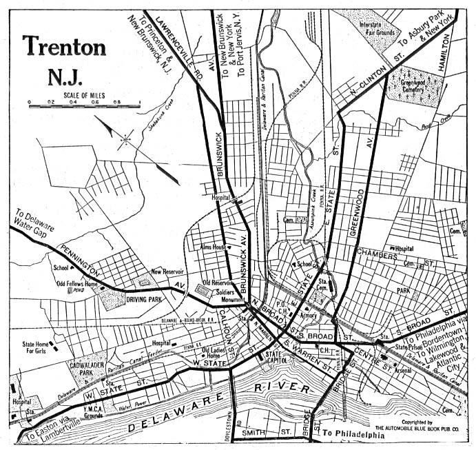
The Lincoln Highway entered Trenton
Trenton, New Jersey
Trenton is the capital of the U.S. state of New Jersey and the county seat of Mercer County. As of the 2010 United States Census, Trenton had a population of 84,913...
along Brunswick Avenue, now northbound US 206
U.S. Route 206
U.S. Route 206 is a long north–south United States highway in New Jersey and Pennsylvania, United States. Only about a half a mile of its length is in Pennsylvania; the Milford-Montague Toll Bridge carries it over the Delaware River into New Jersey, where it is the remainder of the route...
and BUS US 1. Until 1920 the Highway used the Calhoun Street Bridge over the Delaware River
Delaware River
The Delaware River is a major river on the Atlantic coast of the United States.A Dutch expedition led by Henry Hudson in 1609 first mapped the river. The river was christened the South River in the New Netherland colony that followed, in contrast to the North River, as the Hudson River was then...
into Pennsylvania
Pennsylvania
The Commonwealth of Pennsylvania is a U.S. state that is located in the Northeastern and Mid-Atlantic regions of the United States. The state borders Delaware and Maryland to the south, West Virginia to the southwest, Ohio to the west, New York and Ontario, Canada, to the north, and New Jersey to...
; a 1920 map indicates that it probably used Warren Street (now southbound US 206 and BUS US 1) and West State Street to reach the bridge. In 1920 the Highway was moved from the tolled Calhoun Street Bridge to the free Bridge Street Bridge. To get there it probably continued south on Warren Street, turning west on Bridge Street to the bridge. This path is now followed by southbound BUS US 1, with a realignment from Assunpink Creek
Assunpink Creek
Assunpink Creek is a tributary of the Delaware River in western New Jersey in the United States.Assunpink Creek is born in rural Monmouth County, about a mile north of Clarksburg. Flowing westwards, it soon enters the Assunpink Wildlife Management Area, where it has been dammed to form Rising Sun...
to the bridge due to redevelopment.
In 1916, the Lincoln Highway was designated the following State Highway numbers:
- Route 1 from ElizabethElizabeth, New JerseyElizabeth is a city in Union County, New Jersey, United States. As of the 2010 United States Census, the city had a total population of 124,969, retaining its ranking as New Jersey's fourth largest city with an increase of 4,401 residents from its 2000 Census population of 120,568...
to New BrunswickNew Brunswick, New JerseyNew Brunswick is a city in Middlesex County, New Jersey, USA. It is the county seat and the home of Rutgers University. The city is located on the Northeast Corridor rail line, southwest of Manhattan, on the southern bank of the Raritan River. At the 2010 United States Census, the population of... - Route 13 from New Brunswick to TrentonTrenton, New JerseyTrenton is the capital of the U.S. state of New Jersey and the county seat of Mercer County. As of the 2010 United States Census, Trenton had a population of 84,913...
The Highway in Trenton, and in and north of Elizabeth, did not receive a number.
In 1927, the whole Lincoln Highway in New Jersey was assigned the number U.S. Route 1
U.S. Route 1
U.S. Route 1 is a major north–south U.S. Highway that serves the East Coast of the United States. It runs 2,377 miles from Fort Kent, Maine at the Canadian border south to Key West, Florida. U.S. 1 generally parallels Interstate 95, though it is significantly farther west between...
, though that number was soon moved to newer bypasses.
The Route 1 Extension, built in the late 1920s, was considered a bypass of the Lincoln Highway, but the old road has continued to be known as the Lincoln Highway, except possibly between Communipaw Avenue and Tonnelle Circle in Jersey City
Jersey City, New Jersey
Jersey City is the seat of Hudson County, New Jersey, United States.Part of the New York metropolitan area, Jersey City lies between the Hudson River and Upper New York Bay across from Lower Manhattan and the Hackensack River and Newark Bay...
, where the name may have moved to the new road (now TRUCK US 1-9
U.S. Route 1-9 Truck (Jersey City, New Jersey)
U.S. Route 1/9 Truck is a United States highway in the northern part of New Jersey that stretches from the eastern edge of Newark to the Tonnelle Circle in Jersey City. It is the alternate road for U.S. Route 1/9 that trucks must use because they are prohibited from using the Pulaski Skyway, which...
).
Pennsylvania
The path of the Lincoln Highway was first laid out in September 1913; it was defined to run through Canton, Ohio, Beaver Falls, Pittsburgh, Greensburg, Ligonier, Bedford, Chambersburg, Gettysburg, York, Lancaster and Philadelphia, Pennsylvania, and Camden, New Jersey. This bypassed Harrisburg to the south, and thus did not use the older main route across the state between Chambersburg and Lancaster. From Pittsburgh to Philadelphia, this incorporated a number of old turnpikes, some of which still collected tolls.This original 1913 path of the Lincoln Highway continued east from Philadelphia, crossing the Delaware River to Camden, New Jersey on the Market Street Ferry. By 1915, Camden was dropped from the route, allowing the highway to cross the Delaware on a bridge at Trenton (initially the Calhoun Street Bridge, later the Bridge Street Bridge).
In 1924, the entire Lincoln Highway in Pennsylvania was designated Pennsylvania Route 1. In late 1926 the route from West Virginia to Philadelphia (using the new route west of Pittsburgh) was assigned U.S. Route 30, while the rest of the Lincoln Highway and PA 1 became part of U.S. Route 1.
West Virginia
The Lincoln Highway did not enter West VirginiaWest Virginia
West Virginia is a state in the Appalachian and Southeastern regions of the United States, bordered by Virginia to the southeast, Kentucky to the southwest, Ohio to the northwest, Pennsylvania to the northeast and Maryland to the east...
until 1927, when it was rerouted between Pittsburgh, Pennsylvania
Pittsburgh, Pennsylvania
Pittsburgh is the second-largest city in the US Commonwealth of Pennsylvania and the county seat of Allegheny County. Regionally, it anchors the largest urban area of Appalachia and the Ohio River Valley, and nationally, it is the 22nd-largest urban area in the United States...
and East Liverpool, Ohio
East Liverpool, Ohio
As of the census of 2000, there were 13,089 people, 5,261 households, and 3,424 families residing in the city. The population density was 3,010.3 people per square mile . There were 5,743 housing units at an average density of 1,320.8 per square mile...
. The piece in West Virginia ran roughly along present U.S. Route 30
U.S. Route 30
U.S. Route 30 is an east–west main route of the system of United States Numbered Highways, with the highway traveling across the northern tier of the country. It is the third longest U.S. route, after U.S. Route 20 and U.S. Route 6. The western end of the highway is at Astoria, Oregon; the...
, splitting onto the old route at Chester. There it turned southwest on Carolina Avenue (WV 2) before turning northwest on 3rd Street, southwest on Virginia Avenue and north on 1st Street to cross the Ohio River
Ohio River
The Ohio River is the largest tributary, by volume, of the Mississippi River. At the confluence, the Ohio is even bigger than the Mississippi and, thus, is hydrologically the main stream of the whole river system, including the Allegheny River further upstream...
into East Liverpool on the 1897 Chester Bridge. The only realignment before the bridge was demolished in 1970 was in 1938, when US 30 was moved to take Carolina Avenue directly to 1st Street after a new bridge opened over the railroad. Until the current US 30 was finished in 1977, US 30 continued along Carolina Avenue to the Newell Bridge in Newell.
Ohio
The routing through Ohio followed modern US Route 30 to CantonCanton, Ohio
Canton is the county seat of Stark County in northeastern Ohio, approximately south of Akron and south of Cleveland.The City of Caton is the largest incorporated area within the Canton-Massillon Metropolitan Statistical Area...
, then west on State Route 172 to Dalton
Dalton, Ohio
Dalton is a village in Wayne County, Ohio, United States. The population was 1,605 at the 2000 census. Dalton is served by a branch of the Wayne County Public Library.-Geography:Dalton is located at ....
(where it rejoins US Route 30). West of Wooster it turns northwest on U.S. Route 250
U.S. Route 250
U.S. Route 250 is a route of the United States Numbered Highway System, and is a spur of U.S. Route 50. It currently runs for from Sandusky, Ohio to Richmond, Virginia. It passes through the states of Virginia, West Virginia, and Ohio. It goes through the cities of Richmond, Virginia,...
to Ashland
Ashland, Ohio
Ashland is a city in the U.S. state of Ohio and the county seat of Ashland County. The population was 21,249 at the 2000 census. It is the center of the Ashland Micropolitan Statistical Area...
, then southwest on Clairmont Avenue which eventually becomes modern U.S. Route 42
U.S. Route 42
U.S. Route 42 is an east–west United States highway that runs northeast-southwest for 355 miles from Cleveland, Ohio to Louisville, Kentucky. The route has several names including Pearl Road from Cleveland to Medina in Northeast Ohio, the Cincinnati and Lebanon Pike in southwestern Ohio and...
to Mansfield
Mansfield, Ohio
Mansfield is a city in the U.S. state of Ohio and the county seat of Richland County. The municipality is located in north-central Ohio in the western foothills of the Allegheny Plateau, approximately southwest of Cleveland and northeast of Columbus....
. West Fourth Street to US Route 30 which it followed to Bucyrus
Bucyrus, Ohio
As of the census of 2000, there were 13,224 people, 5,559 households, and 3,552 families residing in the city. The population density was 1,812.0 people per square mile . There were 5,955 housing units at an average density of 816.0 per square mile...
(temporarily leaving US 30 to follow Mansfield Street and Lincoln Highway), then continued to Upper Sandusky
Upper Sandusky, Ohio
As of the census of 2000, there were 6,533 people, 2,744 households, and 1,682 families residing in the city. The population density was 1,246.2 people per square mile . There were 2,910 housing units at an average density of 555.1 per square mile...
(went through on Wyandot Avenue to County Route 330). It is a combination of US Route 30 and local roads to the Indiana state line.
Indiana
The Lincoln Highway entered Indiana on current US Route 30 to Fort WayneFort Wayne, Indiana
Fort Wayne is a city in the US state of Indiana and the county seat of Allen County. The population was 253,691 at the 2010 Census making it the 74th largest city in the United States and the second largest in Indiana...
. It turned northwest on modern U.S. Route 33
U.S. Route 33
U.S. Route 33 is a United States federal highway that runs northwest-southeast for 709 miles from northern Indiana to Richmond, Virginia, passing through Ohio and West Virginia en route. Although most odd-numbered U.S...
to Elkhart
Elkhart, Indiana
Elkhart is a city in Elkhart County, Indiana, United States. The city is located east of South Bend, northwest of Fort Wayne, east of Chicago, and north of Indianapolis...
. It turned west on Lincoln Way through South Bend
South Bend, Indiana
The city of South Bend is the county seat of St. Joseph County, Indiana, United States, on the St. Joseph River near its southernmost bend, from which it derives its name. As of the 2010 Census, the city had a total of 101,168 residents; its Metropolitan Statistical Area had a population of 316,663...
to U.S. Route 20
U.S. Route 20
U.S. Route 20 is an east–west United States highway. As the "0" in its route number implies, US 20 is a coast-to-coast route. Spanning , it is the longest road in the United States, and the route sparsely parallels Interstate 90...
. It followed US Route 20 to Rolling Prairie
Rolling Prairie, Indiana
Rolling Prairie is an unincorporated town in Kankakee Township, LaPorte County, Indiana.-History:The first cabin was built here in 1831 by Ezekiel Provolt. More settlers arrived, built cabins and named the settlement Nauvoo. On November 26, 1853, the village was platted by W.J. Walker and named...
and continued on State Road 2 to Valparaiso
Valparaiso, Indiana
Valparaiso is a city in and the county seat of Porter County, Indiana, United States. The population was 31,730 at the 2010 census, making it the 2nd largest city in Porter County.-History:...
where it rejoined US Route 30 to the Illinois state line.
In time, the route was shortened, following U.S. Route 30 through the entire state. Many cities along U.S. 30, including Warsaw
Warsaw, Indiana
Warsaw is a city in and the county seat of Kosciusko County, Indiana, United States. Cradled among Winona Lake, Pike Lake, Hidden Lake and Center Lake, Warsaw is nicknamed "Lake City," though other cities in the surrounding area are also referred to by that nickname...
, Plymouth
Plymouth, Indiana
-Demographics:As of the census of 2000, there were 9,840 people, 3,838 households, and 2,406 families residing in the city. The population density was 1,414.0 people per square mile . There were 4,100 housing units at an average density of 589.2 per square mile...
, Merrillville
Merrillville, Indiana
Merrillville is a town in Ross Township, Lake County, Indiana, United States. The population was 35,246 at the 2010 census. Merrillville is located in the east-central portion of Lake County.-Geography:Merrillville is located at ....
and Schererville
Schererville, Indiana
Schererville is a town in St. John Township, Lake County, Indiana, United States. It is part of the Chicago metropolitan area. The population was 29,243 at the 2010 census.- History :...
contain original stretches of the Lincoln Highway (usually marked as "Old Lincoln Highway", "Lincolnway", "Joliet St" or "Joliet Rd") while modern U.S. 30 runs just outside the cities.
Illinois
The route through Illinois was chosen to deliberately avoid Chicago, instead providing "feeder routes" to the city. The main feeder routes included Illinois Route 1Illinois Route 1
Illinois Route 1 is a state highway in the U.S. state of Illinois. Running parallel to the Indiana border, it is also the longest state road, starting on the south side of Chicago as Halsted Street at the intersection with 95th Street, south to a free ferry crossing to Kentucky at Cave-In-Rock on...
at Chicago Heights
Chicago Heights, Illinois
Chicago Heights is a city in Cook County, Illinois, United States. The population was 31,373 at the 2005 census. Chicago Heights is nicknamed 'Crossroads of the Nation'.-History:...
, Illinois Route 4
Illinois Route 4
Illinois Route 4 is a long state road that runs south from the Interstate 55 business loop around Springfield south to Illinois Route 13 just north of Murphysboro. This is a distance of .-Route description:...
(later U.S. Route 66
U.S. Route 66
U.S. Route 66 was a highway within the U.S. Highway System. One of the original U.S. highways, Route 66 was established on November 11, 1926 -- with road signs erected the following year...
) at Joliet
Joliet, Illinois
Joliet is a city in Will and Kendall Counties in the U.S. state of Illinois, located southwest of Chicago. It is the county seat of Will County. As of the 2010 census, the city was the fourth-most populated in Illinois, with a population of 147,433. It continues to be Illinois' fastest growing...
, and Illinois Route 38
Illinois Route 38
Illinois Route 38 is an east–west state road that runs across northern Illinois. It runs from U.S. Route 52 in downtown Dixon to U.S. Highways 12, 20, and 45 in Westchester. This is a distance of . As Roosevelt Road it continues through Forest Park and into Cicero and Chicago before...
at Geneva
Geneva, Illinois
Geneva is the county seat of Kane County, Illinois. It is located on the western fringe of the Chicago suburbs. As of the 2010 census, the city had a total population of 26,652. Geneva is part of a tri-city area, along with St. Charles and Batavia...
.
The Lincoln Highway entered Illinois on US Route 30 which it followed to Aurora
Aurora, Illinois
Aurora is the second most populous city in the U.S. state of Illinois, and the 112th largest city in the United States. A suburb of Chicago, located west of the Loop, its population in 2010 was 197,899. Originally founded within Kane County, Aurora's city limits have expanded greatly over the past...
where it became Illinois Route 31
Illinois Route 31
Illinois Route 31 is a north–south state road in northeastern Illinois, United States. It runs from U.S. Highway 34 in Oswego north to U.S. Highway 12, near the Wisconsin border, just south of Richmond. Illinois 31 is long.- Route description :...
, which it followed to Illinois Route 38
Illinois Route 38
Illinois Route 38 is an east–west state road that runs across northern Illinois. It runs from U.S. Route 52 in downtown Dixon to U.S. Highways 12, 20, and 45 in Westchester. This is a distance of . As Roosevelt Road it continues through Forest Park and into Cicero and Chicago before...
at Geneva where it turned west to Dixon
Dixon, Illinois
Dixon is a city in Lee County, Illinois, United States. The population was 15,733 as of the 2010 census, down from 15,941 at the 2000 census. Named for its founder, John Dixon , it is the county seat of Lee County. Located on the Rock River, Dixon was the boyhood home of former U.S...
. From Dixon, it continued west on Illinois Route 2
Illinois Route 2
Illinois Route 2 is a north–south state road in northern Illinois. It currently starts at Illinois Route 40 in Sterling and ends at the Wisconsin state line north of South Beloit, very near the intersection with U.S. Route 51, Illinois Route 75 and Illinois Route 251. Illinois 2 is long.-...
to Sterling
Sterling, Illinois
Sterling is a city in Whiteside County, Illinois, United States. The population was 15,370 at the 2010 census, down from 15,451 at the 2000 census. Formerly nicknamed "The Hardware Capital of the World", Sterling has long been associated with manufacturing and the steel...
where it rejoins US Route 30. It followed US Route 30 to just east of the Iowa state line, where it turned slightly northwest of Illinois Route 136
Illinois Route 136
Illinois Route 136 is an east–west road in northwestern Illinois. It runs from the Mark N. Norris Bridge over the Mississippi River, connecting to Iowa Highway 136 in Clinton, Iowa, east to U.S. Route 30 east of Fulton. This is a distance of ....
.
Iowa
The Lincoln Highway entered Iowa on the Lyons-Fulton bridge, since torn down, north of the present-day Iowa Highway 136 bridge. It then went south on Second Street in ClintonClinton, Iowa
Clinton is a city in and the county seat of Clinton County, Iowa, United States. The population was 26231as of 2010. Clinton, along with DeWitt, Iowa , was named in honor of the seventh governor of New York, DeWitt Clinton. Clinton is the principal city of the Clinton Micropolitan Statistical...
along what is now U.S. Route 67
U.S. Route 67
U.S. Route 67 is a 1,560 mile long north–south U.S. highway in the Central United States. The southern terminus of the route is at the United States-Mexico border in Presidio, Texas, where it continues south as Mexican Federal Highway 16 upon crossing the Rio Grande. The northern...
. From there, it generally followed these present-day roads:
- U.S. Route 30U.S. Route 30U.S. Route 30 is an east–west main route of the system of United States Numbered Highways, with the highway traveling across the northern tier of the country. It is the third longest U.S. route, after U.S. Route 20 and U.S. Route 6. The western end of the highway is at Astoria, Oregon; the...
from Clinton to LisbonLisbon, IowaLisbon is a city in Linn County, Iowa, United States, adjacent to the city of Mount Vernon. The population was 2,152 at the 2010 census. It is part of the Cedar Rapids Metropolitan Statistical Area.-Geography:Lisbon is located at ....
, including some roads known today as "Old Highway 30" - Local roads and city streets from Lisbon to MarionMarion, IowaMarion is a city in Linn County, Iowa, United States. The population was 26,294 at the 2000 census and was estimated at 32,172 in 2007. The city is part of the Cedar Rapids Metropolitan Statistical Area.- History :...
and later Cedar RapidsCedar Rapids, IowaCedar Rapids is the second largest city in Iowa and is the county seat of Linn County. The city lies on both banks of the Cedar River, north of Iowa City and east of Des Moines, the state's capital and largest city...
, rejoining present-day 30 on the southwest side of Cedar Rapids - U.S. 30 from there to northeast of Belle PlaineBelle Plaine, IowaBelle Plaine is a city in Benton County, Iowa, United States. The population was 2,878 at the 2000 census. It is part of the Cedar Rapids Metropolitan Statistical Area....
, where it turned south and followed County Roads V40 and E66 through ChelseaChelsea, IowaChelsea is a city in Tama County, Iowa. The population was 287 at the 2000 census. The town is located in the Iowa River Valley and has suffered severe damage in several floods.-Geography:...
and rejoined 30 east of Tama. The famous bridge is just west of where 30 and the Lincoln Highway currently separate. - Local streets in Tama and County Road E49, rejoining 30 near Le GrandLe Grand, IowaLe Grand is a city in Marshall and Tama Counties in the U.S. state of Iowa. The population was 883 at the 2000 census.-Geography:Le Grand's longitude and latitude coordinatesin decimal form are 42.006211, -92.776497...
- U.S. 30 to four miles (6 km) west of Le Grand, where it followed city streets through Marshalltown and left town on Lincoln Way
- County Road E41 from west of Marshalltown which passes north of State Center. Then runs west crossing Hwy 69 at Colo and continues onto Nevada. The Nevada Lincoln Highway Committee has hosted for the past 25 years an annual celebration called Lincoln Highway Days. The route continues on "Old 30 to Ames, about a mile north of "New 30", going along the south and west sides of Iowa State University.
- Gravel roads to Iowa Highway 17, where it again followed County Road E41 through Boone to Ogden
- U.S. 30 from Ogden to Grand Junction, County Road E53 through Greene County, and north through Scranton, then west to near Ralston
- From there it generally followed U.S. 30 to the Missouri ValleyMissouri ValleyMissouri Valley may refer to some places in the United States:* Missouri Valley, Iowa, a small city* The Missouri River Valley* The Missouri Valley Conference, a college athletic conference...
, where it turned south to Council BluffsCouncil Bluffs, IowaCouncil Bluffs, known until 1852 as Kanesville, Iowathe historic starting point of the Mormon Trail and eventual northernmost anchor town of the other emigrant trailsis a city in and the county seat of Pottawattamie County, Iowa, United States and is on the east bank of the Missouri River across...
on County Road L20. It crossed the Missouri RiverMissouri RiverThe Missouri River flows through the central United States, and is a tributary of the Mississippi River. It is the longest river in North America and drains the third largest area, though only the thirteenth largest by discharge. The Missouri's watershed encompasses most of the American Great...
to Omaha, NebraskaOmaha, NebraskaOmaha is the largest city in the state of Nebraska, United States, and is the county seat of Douglas County. It is located in the Midwestern United States on the Missouri River, about 20 miles north of the mouth of the Platte River...
via Broadway and the Ak-Sar-Ben BridgeAk-Sar-Ben BridgeThe Ak-Sar-Ben Bridge was a truss bridge that was the first road bridge to cross the Missouri River connecting Omaha, Nebraska and Council Bluffs, Iowa...
Nebraska
Traveling westward on Dodge StreetDodge Street
Dodge Street is the main east–west street in Omaha, Nebraska. Numbered as U.S. Route 6, the street starts in Downtown Omaha and connects to West Dodge Road around 78th Street. From there it continues westward through the remainder of Douglas County....
, the Lincoln Highway in Omaha went by several landmarks, including upscale motels and an amusement park
Peony Park
Peony Park was an amusement park located at North 78th and Cass Streets in Omaha, Nebraska. Founded in 1919, over the next seventy-five years the park included a pool, beach and waterslide, a ballroom that billed itself as "1 acre under one roof," an open air dance area for 3000 dancers,...
. Leaving the city it took city streets through Waterloo
Waterloo, Nebraska
Waterloo is a village in Douglas County, Nebraska, United States. The population was 459 at the 2000 census.-Geography:Waterloo is located at ....
where it joined U.S. Route 275
U.S. Route 275
U.S. Route 275 is a north–south United States highway. It is a branch of US 75, originally terminating at that route in Council Bluffs, Iowa. The highway's northern terminus is in O'Neill, Nebraska, at an intersection with U.S. Highway 20 and U.S. Highway 281. Its southern terminus is near...
to Fremont
Fremont, Nebraska
Fremont is a city in and the county seat of Dodge County, Nebraska, United States, near Omaha in the eastern part of the state. The population was 26,397 at the 2010 census....
. From Fremont, it continued west on U.S. Route 30
U.S. Route 30
U.S. Route 30 is an east–west main route of the system of United States Numbered Highways, with the highway traveling across the northern tier of the country. It is the third longest U.S. route, after U.S. Route 20 and U.S. Route 6. The western end of the highway is at Astoria, Oregon; the...
through Central City
Central City, Nebraska
Central City is a city in Merrick County, Nebraska, United States. It is part of the Grand Island, Nebraska Micropolitan Statistical Area. The population was 2,998 at the 2000 census...
, North Platte
North Platte, Nebraska
North Platte is a city in and the county seat of Lincoln County, Nebraska, United States. It is located in the southwestern part of the state, along Interstate 80, at the confluence of the North and South Platte Rivers forming the Platte River...
, and Ogallala
Ogallala, Nebraska
Ogallala is a city in Keith County, Nebraska, United States. The population was 4,737 at the 2010 census. It is the county seat of Keith County. In the days of the Nebraska Territory, the city was a stop on the Pony Express and later along the transcontinental railroad...
to the Wyoming state line.
Colorado
The 1913 proclamation included a loop through Denver, ColoradoDenver, Colorado
The City and County of Denver is the capital and the most populous city of the U.S. state of Colorado. Denver is a consolidated city-county, located in the South Platte River Valley on the western edge of the High Plains just east of the Front Range of the Rocky Mountains...
, touching the main route at Big Springs, Nebraska
Big Springs, Nebraska
Big Springs is a village in Deuel County, Nebraska, United States. The population was 418 at the 2000 census.-Geography:Big Springs is located at ....
and Cheyenne, Wyoming
Cheyenne, Wyoming
Cheyenne is the capital and most populous city of the U.S. state of Wyoming and the county seat of Laramie County. It is the principal city of the Cheyenne, Wyoming, Metropolitan Statistical Area which encompasses all of Laramie County. The population is 59,466 at the 2010 census. Cheyenne is the...
. This loop was included, as Colorado
Colorado
Colorado is a U.S. state that encompasses much of the Rocky Mountains as well as the northeastern portion of the Colorado Plateau and the western edge of the Great Plains...
had felt betrayed by the decision not to run through it after supporting the Hoosier Tour earlier that year. The loop was quietly dropped in 1915, but Colorado continued to promote the loop, including a billboard
Billboard (advertising)
A billboard is a large outdoor advertising structure , typically found in high traffic areas such as alongside busy roads. Billboards present large advertisements to passing pedestrians and drivers...
at the Big Springs end. The route is now paralleled by Interstate 76 and Interstate 25
Interstate 25
Interstate 25 is an Interstate Highway in the western United States. It is primarily a north–south highway. I-25 stretches from Interstate 10 at Las Cruces, New Mexico, , to Interstate 90 in Buffalo, Wyoming, .Interstate 25 is the main north–south expressway through...
; it became the following in 1926:
- U.S. Route 138U.S. Route 138U.S. Route 138, commissioned in 1926, is a short east–west highway in Colorado and Nebraska that runs predominantly northeast to southwest paralleling the South Platte River and Interstate 76. Like all spurs of the former U.S. Route 66 and U.S. Route 199, U.S. Route 138 is an orphan route....
, Big Springs to Sterling, ColoradoSterling, ColoradoThe City of Sterling is a Home Rule Municipality that is the county seat and the most populous city of Logan County, Colorado, United States. The city population was 14,777 at the 2010 census.-Geography:Sterling is located at... - U.S. Route 38 (now U.S. Route 6U.S. Route 6U.S. Route 6 , also called the Grand Army of the Republic Highway, a name that honors an American Civil War veterans association, is a main route of the U.S. Highway system, running east-northeast from Bishop, California to Provincetown, Massachusetts. Until 1964, it continued south from Bishop to...
), Sterling to Wiggins, ColoradoWiggins, ColoradoWiggins is a Statutory village in Morgan County, Colorado, United States. The population was 001 at the 2000 census.The community was established in 1882 as the Burlington railroad depot of Corona. Around 1900, Corona was renamed in honor of Oliver P. Wiggins, who served as a guide and scout for... - unnumbered (State Highway 52 and State Highway 79?), Wiggins to Bennett, ColoradoBennett, ColoradoThe town of Bennett is a Statutory Town in Adams and Arapahoe counties in the U.S. state of Colorado. The United States Census Bureau estimates that the town had a population of 2,536 in 2005...
- U.S. Route 40U.S. Route 40U.S. Route 40 is an east–west United States highway. As with most routes whose numbers end in a zero, U.S. 40 once traversed the entire United States. It is one of the original 1920s U.S. Highways, and its first termini were San Francisco, California, and Atlantic City, New Jersey...
, Bennett to Denver - U.S. Route 287U.S. Route 287U.S. Route 287 is a north–south United States highway. It is long. It serves as the major truck route between the Texas cities of Fort Worth and Amarillo...
, Denver, Longmont, Loveland, Fort Collins to Cheyenne, Wyoming. US 287 was not created until 1935, so the Lincoln Highway may well have used a portion of: - Unnumbered (State Highway 1), Fort Collins to Cheyenne. Today this highway does not run north out of Ft. Collins, but it may well have in 1915 or so, perhaps having been absorbed in the "new" US 287.
Wyoming
The Lincoln Highway entered Wyoming east of Pine BluffsPine Bluffs, Wyoming
-Demographics:As of the census of 2000, there were 1,153 people, 482 households, and 332 families residing in the town. The population density was 357.4 people per square mile . There were 517 housing units at an average density of 160.3 per square mile...
. It followed county roads through Egbert and Hillsdale
Hillsdale, Wyoming
Hillsdale is an unincorporated community in southeastern Laramie County, Wyoming, United States. It lies along local roads east of the city of Cheyenne, the county seat of Laramie County. Its elevation is 5,640 feet . Although Hillsdale is unincorporated, it has a post office, with the ZIP...
to Archer where it rejoined US Route 30. It followed US Route 30 (now largely Interstate 80
Interstate 80
Interstate 80 is the second-longest Interstate Highway in the United States, following Interstate 90. It is a transcontinental artery running from downtown San Francisco, California to Teaneck, New Jersey in the New York City Metropolitan Area...
) through Cheyenne
Cheyenne, Wyoming
Cheyenne is the capital and most populous city of the U.S. state of Wyoming and the county seat of Laramie County. It is the principal city of the Cheyenne, Wyoming, Metropolitan Statistical Area which encompasses all of Laramie County. The population is 59,466 at the 2010 census. Cheyenne is the...
, Laramie
Laramie, Wyoming
Laramie is a city in and the county seat of Albany County, Wyoming, United States. The population was 30,816 at the . Located on the Laramie River in southeastern Wyoming, the city is west of Cheyenne, at the junction of Interstate 80 and U.S. Route 287....
, Medicine Bow
Medicine Bow, Wyoming
Medicine Bow is a town in Carbon County, Wyoming, United States. The population was 304 at the 2010 census.-Geography:Medicine Bow is located at ....
, and Rawlins
Rawlins, Wyoming
Rawlins is a city in Carbon County, Wyoming, United States. The population was 8,538 at the 2000 census. It is the county seat of Carbon County...
to Granger Junction. From there, it followed former U.S. Route 30 South and U.S. Route 530 (now Interstate 80) to the Utah state line. At places, the road itself is now Business I-80 in Lyman
Lyman, Wyoming
Lyman is a town in Uinta County, Wyoming, United States. The population was 1,938 at the 2000 census.-Geography:Lyman is located at ....
and follows frontage road
Frontage road
A frontage road is a non-limited access road running parallel to a higher-speed road, usually a freeway, and feeding it at appropriate points of access...
s in many places.
Utah
The Lincoln Highway entered Utah on modern Interstate 80 and followed this to Salt Lake City.In western Utah, the original chosen alignment headed west from Salt Lake City to Timpie in order to run around the north side of the Stansbury Mountains, largely along present State Route 171
State Route 171 (Utah)
State Route 171 is a state highway in the Salt Lake City metropolitan area in northern Utah that runs from SR-111 in Magna in the west side of the city to Interstate 215 in the East Benches in the eastern part of the city...
and State Route 138. From Timpie it turned south roughly along present State Route 196, running to Orr's Ranch (40.306334°N 112.734897°W), now a bit north of the east gate of the Dugway Proving Ground
Dugway Proving Ground
Dugway Proving Ground is a US Army facility located approximately 85 miles southwest of Salt Lake City, Utah in southern Tooele County and just north of Juab County...
).
Between Orr's Ranch and the north edge of the Dugway Range, the original highway ran through the current Dugway Proving Ground around the north side of the Dugway Range (40.037°N 113.223°W). From there it headed south to the Black Rock Hills, joining the old Pony Express
Pony Express
The Pony Express was a fast mail service crossing the Great Plains, the Rocky Mountains, and the High Sierra from St. Joseph, Missouri, to Sacramento, California, from April 3, 1860 to October 1861...
route there (39.880°N 113.254°W). The Lincoln Highway then went west past Fish Springs (39.848°N 113.411°W) and Callao
Callao, Utah
Callao is a small farming community in northern Snake Valley, along the border of Juab County and Tooele County, Utah, United States. It was part of the original Pony Express overland route, and was first called Willow Springs in 1860. E. W. Tripp, his wife and son, were the first to establish...
(39.898°N 113.709°W) and across the Deep Creek Range through the Overland Canyon (40.067°N 113.829°W) to Ibapah
Ibapah, Utah
Ibapah is a small unincorporated community in far western Tooele County, Utah, United States, near the Nevada state line. The town is located near the Deep Creek Mountains. The site was originally established in 1859 by Mormon missionaries sent to teach the local Native Americans farming methods...
(40.036°N 113.983°W), crossing into Nevada soon after. This route is now known by the names of Simpson Springs-Callao Road, Pony Express Road, Overland Canyon Road, Lower Goldhill Road, Ibapah Road and Willow Road.
Around 1919 a new route, known as the Goodyear Cutoff, and named after Goodyear Tire and Rubber, a major donor to the project, was built across desert that is now largely the Dugway Proving Ground. Around the same time, a realignment was made further east. Thus the new route split from the old at Mills Junction and ran south on present State Route 36 through Tooele and Stockton
Stockton, Utah
Stockton is a town in Tooele County, Utah, United States. It is part of the Salt Lake City, Utah Metropolitan Statistical Area. The population was 616 at the 2010 census.-Geography:Stockton is located at ....
to St. John, where it turned west on present State Route 199 and Redding Road, crossing the Stansbury Mountains at Johnson Pass
Johnson Pass
Johnson Creek Summit is a mountain pass through the Kenai Mountains in Southcentral Alaska. It is 23 miles long, and the maximum elevation of the pass is 1450 ft. There is a backpacking trail traversing the entire pass, with access from the south via the Sterling Highway and from the north via...
. At Orr's Ranch it rejoined the old road west to County Well (now the Dog Area of the Dugway Proving Ground), where the Goodyear Cutoff began.
The Goodyear Cutoff cut largely across the Great Salt Lake Desert
Great Salt Lake Desert
The Great Salt Lake Desert is a large dry lake in northern Utah between the Great Salt Lake and the Nevada border which is noted for white sand from evaporite Lake Bonneville salt deposits...
, hitting high areas at Granite Mountain
Granite Mountain (Utah)
Granite Mountain is a mass of solid rock one mile up Little Cottonwood Canyon in the Wasatch Range of Utah, not too far from Salt Lake City, Utah. Despite its name, Granite Mountain is primarily composed of quartz monzonite, an igneous rock similar to granite in appearance, physical...
(40.174°N 113.296°W) and Black Point (40.085°N 113.668°W), and then passing through the Deep Creek Mountains
Deep Creek Mountains
The Deep Creek Mountains, officially the Deep Creek Range, are a mountain range in the Great Basin located in extreme western Tooele County and Juab County, Utah, in the western United States....
via Gold Hill
Gold Hill, Utah
Gold Hill is a small, unincorporated community in far western Tooele County in the U.S. state of Utah near the Nevada state line. The town, located near the Deep Creek Mountains, was the center of a mining district that was active in the late nineteenth and early twentieth centuries, producing...
(40.166°N 113.831°W) and rejoining the older route about halfway from Gold Hill to Ibapah (40.105°N 113.864°W).
However, Utah did not care much for the Lincoln Highway, instead preferring the Victory Highway
Victory Highway
The Victory Highway was an auto trail across the United States between New York City and San Francisco, roughly equivalent to the present U.S. Route 40.-History:...
via Wendover (present Interstate 80
Interstate 80
Interstate 80 is the second-longest Interstate Highway in the United States, following Interstate 90. It is a transcontinental artery running from downtown San Francisco, California to Teaneck, New Jersey in the New York City Metropolitan Area...
). Nevada and northern California also favored that route, northern California because it would assure that travelers did not take the Midland Trail
Midland Trail
For the trail's section in West Virginia see: The Midland Trail in West Virginia.The Midland Trail, also called the Roosevelt Midland Trail, was a national auto trail spanning the United States from Washington, D.C...
to Los Angeles, and so the federal aid route chosen under the Federal Highway Act of 1921 was the Victory Highway, separate from the Lincoln Highway between Mills Junction, Utah and Wadsworth, Nevada
Wadsworth, Nevada
Wadsworth is a census-designated place in Washoe County, Nevada, United States. The population was 881 at the 2000 census. It is part of the Reno–Sparks Metropolitan Statistical Area. The town was named for General James S. Wadsworth, a Civil War general killed at the battle of the...
.
Thus the Goodyear Cutoff was never paved, and was closed to the public in the 1940s when the Dugway Proving Ground
Dugway Proving Ground
Dugway Proving Ground is a US Army facility located approximately 85 miles southwest of Salt Lake City, Utah in southern Tooele County and just north of Juab County...
was formed. In late 1926 the system of United States Numbered Highways
United States Numbered Highways
The system of United States Numbered Highways is an integrated system of roads and highways in the United States numbered within a nationwide grid...
was assigned, and U.S. Route 40
U.S. Route 40
U.S. Route 40 is an east–west United States highway. As with most routes whose numbers end in a zero, U.S. 40 once traversed the entire United States. It is one of the original 1920s U.S. Highways, and its first termini were San Francisco, California, and Atlantic City, New Jersey...
was assigned to the Victory Highway through western Utah. The next year the Lincoln Highway was rerouted to use the Wendover route, turning south on an unnumbered route (numbered U.S. Route 50
U.S. Route 50
U.S. Route 50 is a major east–west route of the U.S. Highway system, stretching just over from Ocean City, Maryland on the Atlantic Ocean to West Sacramento, California. Until 1972, when it was replaced by Interstate Highways west of the Sacramento area, it extended to San Francisco, near...
ca. 1929 and now U.S. Route 93 Alternate
U.S. Route 93 Alternate (Nevada)
In the U.S. state of Nevada, U.S. Route 93 Alternate is an alternate route of U.S. Route 93 located in the northeast part of the state. It connects Lages Station to Wells via the town of West Wendover....
and U.S. Route 93
U.S. Route 93
U.S. Route 93 is a major north–south United States highway in the western United States. The southern terminus is at U.S. Route 60 in Wickenburg, Arizona. The northern terminus is at the Canadian border north of Eureka in Lincoln County, Montana, where the roadway continues into Roosville,...
) at West Wendover, Nevada
West Wendover, Nevada
West Wendover is a city in Elko County, Nevada, United States. The population was 4,721 at the 2000 census. It is part of the Elko Micropolitan Statistical Area. West Wendover is located on the eastern border of Nevada and the western edge of the Great Salt Lake Desert, and is contiguous with...
and rejoining the old route at Schellbourne before turning west on U.S. Route 50
U.S. Route 50
U.S. Route 50 is a major east–west route of the U.S. Highway system, stretching just over from Ocean City, Maryland on the Atlantic Ocean to West Sacramento, California. Until 1972, when it was replaced by Interstate Highways west of the Sacramento area, it extended to San Francisco, near...
at Ely.
Nevada
In Nevada, the highway enters on county roads west of Ibapah, Utah. At Alternate U.S. Route 93U.S. Route 93
U.S. Route 93 is a major north–south United States highway in the western United States. The southern terminus is at U.S. Route 60 in Wickenburg, Arizona. The northern terminus is at the Canadian border north of Eureka in Lincoln County, Montana, where the roadway continues into Roosville,...
, the Lincoln Highway turned south, passing through McGill
McGill, Nevada
McGill is a census-designated place in White Pine County, Nevada, United States. The population was 1,148 at the 2010 census.-Geography:McGill is located at ....
to Ely
Ely, Nevada
Ely is the largest city and county seat of White Pine County, Nevada, United States. Ely was founded as a stagecoach station along the Pony Express and Central Overland Route. Ely's mining boom came later than the other towns along US 50, with the discovery of copper in 1906...
. From Ely to Fallon
Fallon, Nevada
-Demographics:As of the census of 2000, there were 7,536 people, 3,004 households, and 1,877 families residing in the city. The population density was 2,474.1 people per square mile . There were 3,336 housing units at an average density of 1,095.2 per square mile...
, it followed U.S. Route 50
U.S. Route 50
U.S. Route 50 is a major east–west route of the U.S. Highway system, stretching just over from Ocean City, Maryland on the Atlantic Ocean to West Sacramento, California. Until 1972, when it was replaced by Interstate Highways west of the Sacramento area, it extended to San Francisco, near...
. A shortcut is now Nevada State Route 722
Nevada State Route 722
State Route 722 is a state highway in Churchill County and Lander County in the U.S. state of Nevada. The highway is an old routing of U.S. Route 50, and previously the Lincoln Highway. What is now route 722 crosses the Desatoya Mountains via Carroll Summit...
between Austin
Austin, Nevada
Austin is a small, unincorporated community located in Lander County, Nevada, in the United States. As of 2004, its population is approximately 340. It is located on the western slopes of the Toiyabe Range at an elevation of . U.S...
and Middlegate
Middlegate, Nevada
Middlegate is an unincorporated community in Churchill County, Nevada, United States.The local bar, gas station and restaurant of Middlegate were the location for Black Road, Gregory Hutton's award-winning 2002 short film starring William Nilon....
.
West of Fallon, the Sierra Nevada Northern Route followed Alternate US Route 50 to Fernley, then old US 40 (paralleling I-80) through Reno
Reno, Nevada
Reno is the county seat of Washoe County, Nevada, United States. The city has a population of about 220,500 and is the most populous Nevada city outside of the Las Vegas metropolitan area...
to Verdi, Nevada on the California state line.
To get to Carson City
Carson City, Nevada
The Consolidated Municipality of Carson City is the capital of the state of Nevada. The words Consolidated Municipality refer to a series of changes in 1969 which abolished Ormsby County and merged all the settlements contained within its borders into Carson City. Since that time Carson City has...
from Reno
Reno, Nevada
Reno is the county seat of Washoe County, Nevada, United States. The city has a population of about 220,500 and is the most populous Nevada city outside of the Las Vegas metropolitan area...
, the current routing of US 395 was used.
The Sierra Nevada Southern Route continued down US Route 50 from Fallon through Carson City
Carson City, Nevada
The Consolidated Municipality of Carson City is the capital of the state of Nevada. The words Consolidated Municipality refer to a series of changes in 1969 which abolished Ormsby County and merged all the settlements contained within its borders into Carson City. Since that time Carson City has...
then up King's Canyon Grade, over Spooner Summit, and around the south end of Lake Tahoe
Lake Tahoe
Lake Tahoe is a large freshwater lake in the Sierra Nevada of the United States. At a surface elevation of , it is located along the border between California and Nevada, west of Carson City. Lake Tahoe is the largest alpine lake in North America. Its depth is , making it the USA's second-deepest...
to Stateline, Nevada
Stateline, Nevada
-Demographics:As of the census of 2000, there were 1,215 people, 510 households, and 245 families residing in the CDP. The population density was 1,803.3 people per square mile . There were 562 housing units at an average density of 834.1 per square mile...
on the California state line.
California
In California, the Lincoln Highway followed two different routes over the Sierra Nevada.The Sierra Nevada Northern Route from Verdi, Nevada to Sacramento
Sacramento
Sacramento is the capital of the state of California, in the United States of America.Sacramento may also refer to:- United States :*Sacramento County, California*Sacramento, Kentucky*Sacramento – San Joaquin River Delta...
followed the old Dog Valley / Henness Pass route from Verdi to Truckee
Truckee, California
Truckee is an incorporated town in Nevada County, California, United States. The population was 16,180 at the 2010 census, up from 13,864 at the 2000 census.-Name:...
, then westbound on Donner Pass Road (old US 40) up to the top of Donner Pass
Donner Pass
Donner Pass is a mountain pass in the northern Sierra Nevada, located above Donner Lake about nine miles west of Truckee, California. It has a steep approach from the east and a gradual approach from the west....
, then continuing west on Donner Pass Rd, Hampshire Rocks Rd and various other mountain roads parallelling I-80 through Emigrant Gap
Emigrant Gap, California
Emigrant Gap is an unincorporated community in Placer County, California. Emigrant Gap is located southwest of Emigrant Gap. It lies at an elevation of 5190 feet ....
, Magra
Magra, California
Magra is an unincorporated community in Placer County, California. Magra is located on the Southern Pacific Railroad, northeast of Colfax. It lies at an elevation of 2887 feet ....
, Colfax
Colfax, California
Colfax is a city in Placer County, California, at the crossroads of Interstate 80 and State Route 174. It is part of the Sacramento–Arden-Arcade–Roseville Metropolitan Statistical Area. The population was 1,963 at the 2010 census...
, Weimar
Weimar, California
Weimar is an unincorporated community in Placer County, California, located in the Sacramento area. Weimar is located south-southwest of Colfax....
, Applegate
Applegate, California
Applegate is an unincorporated community in Placer County, California. Applegate is located south-southwest of Colfax.It lies at an elevation of 2005 feet . Its ZIP code is 95703 and its area code 530....
, and Auburn
Auburn, California
Auburn is the county seat of Placer County, California. Its population at the 2010 census was 13,330. Auburn is known for its California Gold Rush history.Auburn is part of the Greater Sacramento area.- History :...
. The route then continued southwest on what became old US 40 through the northeastern Sacramento outreaches of Newcastle, Loomis, Rocklin, and Roseville, then turned south on Auburn Blvd to Citrus Heights, then turned southwest, following Auburn Blvd, Del Paso Blvd, and 12th Street into downtown Sacramento to the California State Capitol
California State Capitol
The California State Capitol is home to the government of California. The building houses the bicameral state legislature and the office of the governor....
.
The Sierra Nevada Southern Route from Stateline, Nevada
Stateline, Nevada
-Demographics:As of the census of 2000, there were 1,215 people, 510 households, and 245 families residing in the CDP. The population density was 1,803.3 people per square mile . There were 562 housing units at an average density of 834.1 per square mile...
and Lake Tahoe
Lake Tahoe
Lake Tahoe is a large freshwater lake in the Sierra Nevada of the United States. At a surface elevation of , it is located along the border between California and Nevada, west of Carson City. Lake Tahoe is the largest alpine lake in North America. Its depth is , making it the USA's second-deepest...
to Sacramento followed the Pioneer Trail and Meyers Grade Road to the top of Echo Summit
Echo Summit
Echo Summit is a mountain pass located in eastern El Dorado County, California, USA. At an elevation of , it is the highest point on U.S...
, then westbound on Johnson Pass Rd to US 50, then westbound on 50 (with many adjacent parallel jogs on mountain roads) through Twin Bridges, Strawberry, Kyburz, Whitehall, Riverton, and Pacific House. At Pollock Pines, the route followed the Pony Express Trail and Carson Road to Broadway and Main Street in Placerville. West of Placerville the route followed Forni Rd, Pleasant Valley Rd, Mother Lode Dr, Durock Rd, Country Club Dr, Old Bass Lake Rd, White Rock Rd, Placerville Rd, and East Bidwell St into Folsom. It turned west through downtown Folsom, then southwest on Folsom Blvd following it all the way into downtown Sacramento, arriving at the California State Capitol on M St (now Capitol Mall).
From Sacramento to San Francisco, the original 1913-1927 Central Valley Route departed Sacramento southbound on Stockton Blvd to Rt 99
California State Route 99
California State Route 99 , commonly known as Highway 99 or, simply, as 99 , is a north–south state highway in the U.S. state of California, stretching almost the entire length of the Central Valley...
, then southbound on 99 to Galt, then south on Lower Sacramento Rd to Pacific Ave and El Dorado St into downtown Stockton
Stockton, California
Stockton, California, the seat of San Joaquin County, is the fourth-largest city in the Central Valley of the U.S. state of California. With a population of 291,707 at the 2010 census, Stockton ranks as this state's 13th largest city...
. From Stockton, the route departed southbound on Center St to French Camp Turnpike, Manthey Rd, and French Camp Rd to the town of French Camp, then Harlan Rd and Manthey Rd (again) southwest to 11th St into Banta, jogging through Banta, then west on 11th (again) into Tracy (old US 50). From Tracy, it followed Byron Rd, Grant Line Rd and Altamont Pass Rd to the top of Altamont Pass
Altamont Pass
Altamont Pass, formerly Livermore Pass, is a mountain pass in the Diablo Range between Livermore in the Livermore Valley and Tracy in the San Joaquin Valley in Northern California...
. It continued west on Altamont Pass Rd arriving in Livermore via Northfront Rd, Vasco Rd, First St and Junction Ave. From Livermore, the route followed today's I-580
Interstate 580 (California)
Interstate 580 is an 80-mile east–west Interstate Highway in Northern California. The heavily traveled spur route of Interstate 80 runs from San Rafael in the San Francisco Bay Area to Interstate 5 near Tracy in the Central Valley...
westbound into Dublin, then Dublin Canyon Rd, East Castro Valley Rd, Grove Way and A Street into downtown Hayward. From Hayward to downtown Oakland it followed Foothill Blvd, I-580 (again), MacArthur Blvd, Foothill Blvd (again), First Ave, 13th St, Harrison St, 9th St and Broadway to a ferry pier on the Oakland Estuary
Oakland Estuary
The Oakland Estuary is the body of water separating the cities of Oakland and Alameda, California, in the San Francisco Bay Area. On its western end it connects to San Francisco Bay, while its eastern end connects to San Leandro Bay.-Crossings:...
(now Jack London Square
Jack London Square
Jack London Square is a popular tourist attraction on the waterfront of Oakland, California. Named after the author Jack London and owned by the Port of Oakland, it is the home of stores, restaurants, hotels, an Amtrak station, a ferry dock, the historic Saloon, the cabin Jack London lived in the...
) for an automobile ferry to the Ferry Slips at the south end of the Ferry Building
Ferry Building
The San Francisco Ferry Building is a terminal for ferries that travel across the San Francisco Bay and a shopping center located on The Embarcadero in San Francisco, California. On top of the building is a large clock tower, which can be seen from Market Street, a main thoroughfare of the city...
, at the base of Market Street
Market Street (San Francisco)
Market Street is an important thoroughfare in San Francisco, California. It begins at The Embarcadero in front of the Ferry Building at the northeastern edge of the city and runs southwest through downtown, passing the Civic Center and the Castro District, to the intersection with Corbett Avenue in...
, in San Francisco.
Upon the completion of the first Carquinez Strait Bridge
Carquinez Bridge
The Carquinez Bridge refers to parallel bridges spanning the Carquinez Strait, forming part of Interstate 80 between Crockett and Vallejo, California. The name originally referred to a single cantilever bridge built in 1927, helping to form a direct route between San Francisco and Sacramento. A...
at Vallejo in 1927, the Lincoln Highway from Sacramento to San Francisco was re-routed over this much shorter alignment. The 1928 Central Valley Route departed the California State Capitol in Sacramento heading westbound on Capitol Mall, West Capitol Avenue, and across the Yolo Causeway
Yolo Causeway
The Yolo Causeway is a 3.2-mile long elevated highway viaduct on Interstate 80 that crosses the Yolo Bypass floodplain and connects the cities of Sacramento, California and Davis, California ....
to Davis. West of Davis the route followed old US 40 as it "stairstepped" through the towns of Dixon, Vacaville, Fairfield, Rockville, and Cordellia. From Cordellia the route followed Rt 12 (Jameson Canyon Rd) into the base of Napa Valley, then turned south to follow Rt 29 and Broadway into Vallejo, where it followed Alameda St and Fifth St to the Carquinez Strait Bridge. South of the bridge, it followed San Pablo Avenue all the way through Rodeo, Pinole, San Pablo, Richmond, El Cerrito and Albany to Berkeley, where it turned west on University Ave to end at the Berkeley Pier
Berkeley Pier
The Berkeley Pier is a pier in Berkeley, California. When constructed, the pier extended 3.5 miles into San Francisco Bay from the end of University Avenue. Due to extensive filling of the bay and the creation of the Berkeley Marina, it presently extends only 2.5 miles...
for a ferry to the Hyde Street Pier
Hyde Street Pier
The Hyde Street Pier is a historic ferry pier located on the northern waterfront of San Francisco, California, amidst the tourist zone of Fisherman's Wharf....
in San Francisco.
Arriving in San Francisco from 1913 to 1921, you departed the ferry from Oakland at the Ferry Slips at the south end of the Ferry Building, drove west on Market St, right on Van Ness Ave, left on Chestnut St (past the 1915 Panama-Pacific Exhibition
Panama-Pacific International Exposition (1915)
The Panama-Pacific International Exposition was a world's fair held in San Francisco, California between February 20 and December 4 in 1915. Its ostensible purpose was to celebrate the completion of the Panama Canal, but it was widely seen in the city as an opportunity to showcase its recovery...
), entered the Presidio
Presidio of San Francisco
The Presidio of San Francisco is a park on the northern tip of the San Francisco Peninsula in San Francisco, California, within the Golden Gate National Recreation Area...
via the Lombard Gates, departed the Presidio via the Arguello Gates, right on Lake St, left on El Camino del Mar, entering into Lincoln Park
Lincoln Park (San Francisco)
Lincoln Park in San Francisco, California, was dedicated to President Abraham Lincoln in 1909 and includes about of the northwestern corner of the San Francisco Peninsula....
from the northwest.
Arriving in San Francisco from 1922 to 1927, you departed the ferry from Oakland at the Ferry Slips at the south end of the Ferry Building, drove west on Market St, right on Post St, left on Presidio Ave, right on Geary Boulevard
Geary Boulevard
Geary Boulevard is a major east-west thoroughfare in San Francisco, California, beginning downtown at Market Street near Market Street's intersection with Montgomery Street, and running westbound through downtown, the Civic Center area, the Western Addition, and running for most of its length...
, right on 36th Ave, entering into Lincoln Park from the south (now enter via 34th).
Arriving in San Francisco in 1928, you departed the ferry from Berkeley at the Hyde St Pier, drove south on Hyde, right on North Point St, left on Van Ness Ave, right on California St, right on 32nd Avenue, left on El Camino del Mar, entering into Lincoln Park from the northwest.
The Lincoln Highway Western Terminus is the plaza and fountain in front of the Palace of the Legion of Honor in Lincoln Park
Lincoln Park (San Francisco)
Lincoln Park in San Francisco, California, was dedicated to President Abraham Lincoln in 1909 and includes about of the northwestern corner of the San Francisco Peninsula....
. The Western Terminus Marker and the Interpretive Plaque is located at the southeast corner of the plaza, next to the bus stop, adjacent to the entrance drive leading up from 34th Ave.