
.gif)
U.S. Route 1-9 Truck (Jersey City, New Jersey)
Encyclopedia
U.S. Route 1/9 Truck is a United States highway in the northern part of New Jersey
that stretches 4.11 mi (6.61 km) from the eastern edge of Newark
to the Tonnelle Circle in Jersey City
. It is the alternate road for U.S. Route 1/9 that trucks must use because they are prohibited from using the Pulaski Skyway
, which carries the main routes of U.S. Route 1/9
. It also serves traffic accessing the New Jersey Turnpike
, Route 440, and Route 7. The route is a four- to six-lane road its entire length, with portions of it being a divided highway
, that runs through urban areas. From its south end to about halfway through Kearny, U.S. Route 1/9 Truck is freeway-standard, with access to other roads controlled by interchanges.
While the U.S. Route 1/9 Truck designation was first used in 1953, the roadway comprising the route was originally designated as an extension of pre-1927 Route 1 in 1922, a route that in its full length stretched from Trenton
to Jersey City. U.S. Route 1/9 was designated along the road in 1926 and one year later, in 1927, this portion of pre-1927 Route 1 was replaced with Route 25 as well as with a portion of Route 1 north of the Communipaw Avenue intersection. Following the opening of the Pulaski Skyway in 1932, U.S. Route 1/9 and Route 25 were realigned to the new skyway. After trucks were banned from the skyway in 1934, the portion of Route 25 between Newark and Route 1 was designated as Route 25T. In 1953, U.S. Route 1/9 Truck was designated in favor of Route 25T and Route 1 along this segment of road. The portion of the truck route north of Route 7 is being rebuilt as part of a $271.9 million project to construct new approach roads to connect Route 1&9T, Route 7, the Pulaski Skyway, Route 139, and Route 1&9 north of Tonnele Circle
and local streets in Jersey City. Construction, which started in late 2008, is expected to be complete in late 2012.
 U.S. Route 1/9 Truck begins at an interchange with access to and from the southbound direction U.S. Route 1/9
, the Pulaski Skyway
, in the Ironbound
section of the city of Newark
in Essex County
. The truck route is meant to bypass the portion of U.S. Route 1/9 along the Pulaski Skyway, which trucks are restricted from. It merges onto Raymond Boulevard
, which continues west from the U.S. Route 1/9 and U.S. Route 1/9 Truck interchange into downtown Newark
. The truck restriction on Route 1/9 is for the "safety and welfare of the public" according to the New Jersey Department of Transportation not a specific bridge defect. At this point, the truck route becomes a four-lane divided highway
, heading to the east. A short distance later, the road comes to an interchange with the New Jersey Turnpike
(Interstate 95
) and Doremus Avenue before crossing over the Passaic River
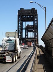
on a drawbridge
. Here, the route enters Kearny
in Hudson County
and continues east into industrial areas as the Lincoln Highway
. The road has a right-in/right-out
in both directions that provides access to Jacobus Avenue before it comes to an interchange with County Route 659. From here, U.S. Route 1/9 Truck becomes a six-lane divided highway and comes to an at-grade intersection with Hackensack Avenue. Past this intersection, the road crosses the Hackensack River
on a drawbridge and enters Jersey City
. Upon entering Jersey City, the road becomes Communipaw Avenue and intersects the northern terminus of Route 440 near the Hudson Mall.
In anticipation of a general increase of activity in Port of New York and New Jersey
and new development on West Side
and Hackensack Riverfront
studies are being conducted to make the intersection a multi-level traffic circle
and northern and southern (Rte 440) approaches to it into a multi-use urban boulevard that includes grade separations and additional meridians.
At this intersection, Communipaw
Avenue continues to the east and U.S. Route 1/9 Truck turns to the north, becoming an unnamed four-lane undivided road. bisecting Lincoln Park
before coming to an intersection with County Route 605. Here, the road becomes a four-lane divided highway again, passing some urban business areas before running between wetlands to the west and Holy Name Cemetery to the east. The route heads into more commercial areas again before passing urban residences, coming to an intersection that provides access to the Pulaski Skyway. Here, U.S. Route 1/9 Truck turns east on Broadway, running through a business district. A short distance later, it turns north onto an unnamed road with County Route 642 continuing east on Broadway. The route passes under a Conrail Shared Assets Operations
railroad line and PATH
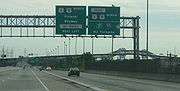
's Newark – World Trade Center Line before crossing under the Pulaski Skyway. Immediately after, U.S. Route 1/9 Truck intersects the eastern terminus of Route 7 and turns to the east, with County Route 645 continuing north at this intersection. The truck route becomes a four-lane undivided road that runs to the north of the Pulaski Skyway and passes through industrial sectors, crossing over a railroad line and County Route 646, known as St. Paul's Avenue, on a new viaduct that had replaced a 1928 structure. Trafic reconfiguration was completed in September 2011. A short distance later, U.S. Route 1/9 Truck comes to the Tonnele Circle
with U.S. Route 1/9 and Route 139, where it ends.
 What is now U.S. 1/9 Truck between Newark and Jersey City was originally the Newark Plank Road
; in 1913 this became the first segment of the Lincoln Highway
. The current route of U.S. Route 1/9 Truck was designated to be an extension of pre-1927 Route 1 in 1922, a route that was to run from Trenton
to Jersey City. When the U.S. Highway System was established in 1926, the current truck route became a part of the U.S. Route 1/9 concurrency. A year later, in the 1927 New Jersey state highway renumbering
, Route 25 was designated to run along the entire length of the route along with U.S. Route 1/9 as part of its journey from the Benjamin Franklin Bridge
in Camden
to the Holland Tunnel
in Jersey City, while Route 1 was also designated along the portion north of Communipaw Avenue in Jersey City as a part of its routing from Bayonne
to Rockleigh
. Following the opening of the Pulaski Skyway in 1932, U.S. Route 1/9 and Route 25 were moved to the new bridge. After trucks were banned from the Pulaski Skyway in 1934, the portion of Route 25 between Newark and Route 1 was designated as Route 25T. In the 1953 New Jersey state highway renumbering
, U.S. Route 1/9 Truck was designated to replace all of Route 25T as well as the portion of Route 1 between Route 25T and the Tonnele Circle. Beginning in late 2008 the New Jersey Department of Transportation
replaced the viaduct that carries the route over St. Paul's Avenue, which was built in 1928 and determined structurally deficient. The $271.9 million replacement, was completed in 2011. In addition to replacing the St. Paul's Avenue viaduct, the approaches to U.S. Route 1/9 Truck between Route 7 and the Tonnele Circle will be improved.
New Jersey
New Jersey is a state in the Northeastern and Middle Atlantic regions of the United States. , its population was 8,791,894. It is bordered on the north and east by the state of New York, on the southeast and south by the Atlantic Ocean, on the west by Pennsylvania and on the southwest by Delaware...
that stretches 4.11 mi (6.61 km) from the eastern edge of Newark
Newark, New Jersey
Newark is the largest city in the American state of New Jersey, and the seat of Essex County. As of the 2010 United States Census, Newark had a population of 277,140, maintaining its status as the largest municipality in New Jersey. It is the 68th largest city in the U.S...
to the Tonnelle Circle in Jersey City
Jersey City, New Jersey
Jersey City is the seat of Hudson County, New Jersey, United States.Part of the New York metropolitan area, Jersey City lies between the Hudson River and Upper New York Bay across from Lower Manhattan and the Hackensack River and Newark Bay...
. It is the alternate road for U.S. Route 1/9 that trucks must use because they are prohibited from using the Pulaski Skyway
Pulaski Skyway
The General Pulaski Skyway is a four-lane freeway composed of connected bridges in the northeastern part of the U.S. state of New Jersey, carrying the designation of U.S. Route 1/9 for most of its length. The landmark structure has a total length of with the longest bridge spanning...
, which carries the main routes of U.S. Route 1/9
U.S. Route 1/9
U.S. Route 9 is a U.S. highway in the northeast United States, running from Laurel, Delaware north to the Canadian border near Champlain, New York...
. It also serves traffic accessing the New Jersey Turnpike
New Jersey Turnpike
The New Jersey Turnpike is a toll road in New Jersey, maintained by the New Jersey Turnpike Authority. According to the International Bridge, Tunnel and Turnpike Association, the Turnpike is the nation's sixth-busiest toll road and is among one of the most heavily traveled highways in the United...
, Route 440, and Route 7. The route is a four- to six-lane road its entire length, with portions of it being a divided highway
Divided Highway
Divided Highway is a compilation album by American rock band The Doobie Brothers, released in 2003. . All tracks are taken from the albums Cycles and Brotherhood .-Track listing:...
, that runs through urban areas. From its south end to about halfway through Kearny, U.S. Route 1/9 Truck is freeway-standard, with access to other roads controlled by interchanges.
While the U.S. Route 1/9 Truck designation was first used in 1953, the roadway comprising the route was originally designated as an extension of pre-1927 Route 1 in 1922, a route that in its full length stretched from Trenton
Trenton, New Jersey
Trenton is the capital of the U.S. state of New Jersey and the county seat of Mercer County. As of the 2010 United States Census, Trenton had a population of 84,913...
to Jersey City. U.S. Route 1/9 was designated along the road in 1926 and one year later, in 1927, this portion of pre-1927 Route 1 was replaced with Route 25 as well as with a portion of Route 1 north of the Communipaw Avenue intersection. Following the opening of the Pulaski Skyway in 1932, U.S. Route 1/9 and Route 25 were realigned to the new skyway. After trucks were banned from the skyway in 1934, the portion of Route 25 between Newark and Route 1 was designated as Route 25T. In 1953, U.S. Route 1/9 Truck was designated in favor of Route 25T and Route 1 along this segment of road. The portion of the truck route north of Route 7 is being rebuilt as part of a $271.9 million project to construct new approach roads to connect Route 1&9T, Route 7, the Pulaski Skyway, Route 139, and Route 1&9 north of Tonnele Circle
Tonnele Circle
The Tonnele Circle is an intersection in Jersey City, New Jersey, United States. It is named after Tonnele Avenue, the north-south road that runs through it. Entrances and exits are, listed clockwise from north:*Tonnele Avenue north...
and local streets in Jersey City. Construction, which started in late 2008, is expected to be complete in late 2012.
Route description
U.S. Route 1/9
U.S. Route 9 is a U.S. highway in the northeast United States, running from Laurel, Delaware north to the Canadian border near Champlain, New York...
, the Pulaski Skyway
Pulaski Skyway
The General Pulaski Skyway is a four-lane freeway composed of connected bridges in the northeastern part of the U.S. state of New Jersey, carrying the designation of U.S. Route 1/9 for most of its length. The landmark structure has a total length of with the longest bridge spanning...
, in the Ironbound
Ironbound
The Ironbound is a large working-class neighborhood in Newark, New Jersey. This close-knit, multi-ethnic community covers approximately four square miles . Historically, the area was called "Dutch Neck," "Down Neck," or simply "the Neck," because of the way the Passaic River curved to form what...
section of the city of Newark
Newark, New Jersey
Newark is the largest city in the American state of New Jersey, and the seat of Essex County. As of the 2010 United States Census, Newark had a population of 277,140, maintaining its status as the largest municipality in New Jersey. It is the 68th largest city in the U.S...
in Essex County
Essex County, New Jersey
Essex County is a county located in the northeastern part of the U.S. state of New Jersey. As of the United States 2010 Census, the population was 783,969, ranking it third in the state after Bergen County and Middlesex County; Essex County's population has declined from 786,147 as of the bureau's...
. The truck route is meant to bypass the portion of U.S. Route 1/9 along the Pulaski Skyway, which trucks are restricted from. It merges onto Raymond Boulevard
Raymond Boulevard
Raymond Boulevard is a major thoroughfare in Newark, New Jersey. The eastern portion of the road acts as the westbound member of a one-way pair; eastbound traffic uses Market Street and Ferry Street...
, which continues west from the U.S. Route 1/9 and U.S. Route 1/9 Truck interchange into downtown Newark
Downtown Newark
Downtown Newark is Newark, New Jersey's major central business, retail, and cultural district. It is located at a bend in the Passaic River.Downtown is the site of the original Puritan settlement of Newark. The first settlers, led by Robert Treat, landed not far from the present site of the New...
. The truck restriction on Route 1/9 is for the "safety and welfare of the public" according to the New Jersey Department of Transportation not a specific bridge defect. At this point, the truck route becomes a four-lane divided highway
Divided Highway
Divided Highway is a compilation album by American rock band The Doobie Brothers, released in 2003. . All tracks are taken from the albums Cycles and Brotherhood .-Track listing:...
, heading to the east. A short distance later, the road comes to an interchange with the New Jersey Turnpike
New Jersey Turnpike
The New Jersey Turnpike is a toll road in New Jersey, maintained by the New Jersey Turnpike Authority. According to the International Bridge, Tunnel and Turnpike Association, the Turnpike is the nation's sixth-busiest toll road and is among one of the most heavily traveled highways in the United...
(Interstate 95
Interstate 95 in New Jersey
Interstate 95 is a major Interstate Highway that traverses the full extent of the East Coast of the United States, from Florida to Maine...
) and Doremus Avenue before crossing over the Passaic River
Passaic River
The Passaic River is a mature surface river, approximately 80 mi long, in northern New Jersey in the United States. The river in its upper course flows in a highly circuitous route, meandering through the swamp lowlands between the ridge hills of rural and suburban northern New Jersey,...
on a drawbridge
Drawbridge
A drawbridge is a type of movable bridge typically associated with the entrance of a castle surrounded by a moat. The term is often used to describe all different types of movable bridges, like bascule bridges and lift bridges.-Castle drawbridges:...
. Here, the route enters Kearny
Kearny, New Jersey
Kearny is a town in Hudson County, New Jersey, United States. It was named after Civil War general Philip Kearny. As of the United States 2010 Census, the town population was 40,684. The town is a suburb of the nearby city of Newark....
in Hudson County
Hudson County, New Jersey
Hudson County is the smallest county in New Jersey and one of the most densely populated in United States. It takes its name from the Hudson River, which creates part of its eastern border. Part of the New York metropolitan area, its county seat and largest city is Jersey City.- Municipalities...
and continues east into industrial areas as the Lincoln Highway
Lincoln Highway
The Lincoln Highway was the first road across the United States of America.Conceived and promoted by entrepreneur Carl G. Fisher, the Lincoln Highway spanned coast-to-coast from Times Square in New York City to Lincoln Park in San Francisco, originally through 13 states: New York, New Jersey,...
. The road has a right-in/right-out
Right-in/right-out
Right-in/right-out and left-in/left-out refer to a type of road intersection where turning movements of vehicles are restricted. A RIRO permits only right turns and a LILO permits only left turns. RIRO is usual where vehicles drive on the right, and LILO is usual where vehicles drive on the left...
in both directions that provides access to Jacobus Avenue before it comes to an interchange with County Route 659. From here, U.S. Route 1/9 Truck becomes a six-lane divided highway and comes to an at-grade intersection with Hackensack Avenue. Past this intersection, the road crosses the Hackensack River
Hackensack River
The Hackensack River is a river, approximately 45 miles long, in the U.S. states of New York and New Jersey, emptying into Newark Bay, a back chamber of New York Harbor. The watershed of the river includes part of the suburban area outside New York City just west of the lower Hudson River,...
on a drawbridge and enters Jersey City
Jersey City, New Jersey
Jersey City is the seat of Hudson County, New Jersey, United States.Part of the New York metropolitan area, Jersey City lies between the Hudson River and Upper New York Bay across from Lower Manhattan and the Hackensack River and Newark Bay...
. Upon entering Jersey City, the road becomes Communipaw Avenue and intersects the northern terminus of Route 440 near the Hudson Mall.
In anticipation of a general increase of activity in Port of New York and New Jersey
Port of New York and New Jersey
The Port of New York and New Jersey comprises the waterways in the estuary of the New York-Newark metropolitan area with a port district encompassing an approximate area within a radius of the Statue of Liberty National Monument...
and new development on West Side
West Side, Jersey City
The West Side of Jersey City is a made of several diverse neighborhoods on either side of West Side Avenue, one of the city's main shopping streets...
and Hackensack Riverfront
Hackensack RiverWalk
Hackensack RiverWalk a is partially constructed greenway along the Newark Bay and Hackensack River on the west side of the Bergen Neck peninsula in Hudson County, New Jersey...
studies are being conducted to make the intersection a multi-level traffic circle
Traffic circle
A traffic circle or rotary is a type of circular intersection in which traffic must travel in one direction around a central island. In some countries, traffic entering the circle has the right-of-way and drivers in the circle must yield. In many other countries, traffic entering the circle must...
and northern and southern (Rte 440) approaches to it into a multi-use urban boulevard that includes grade separations and additional meridians.
At this intersection, Communipaw
Communipaw
Communipaw is a section of Jersey City, New Jersey west of Liberty State Park and east of Bergen Hill, and site of one the earliest European settlements in North America. It gives its name to the historic avenue which runs from its eastern end near LSP Station through the neighborhoods of...
Avenue continues to the east and U.S. Route 1/9 Truck turns to the north, becoming an unnamed four-lane undivided road. bisecting Lincoln Park
Lincoln Park (Jersey City)
Lincoln Park is an urban park in Jersey City, New Jersey with an area of . Opened in 1905, it was originally known as West Side Park. The park was designed by Daniel W. Langton and Charles N. Lowrie, both founding members of the American Society of Landscape Architects.The park consists of two...
before coming to an intersection with County Route 605. Here, the road becomes a four-lane divided highway again, passing some urban business areas before running between wetlands to the west and Holy Name Cemetery to the east. The route heads into more commercial areas again before passing urban residences, coming to an intersection that provides access to the Pulaski Skyway. Here, U.S. Route 1/9 Truck turns east on Broadway, running through a business district. A short distance later, it turns north onto an unnamed road with County Route 642 continuing east on Broadway. The route passes under a Conrail Shared Assets Operations
Conrail Shared Assets Operations
Conrail Shared Assets Operations is an American railroad company. It operates three networks—the North Jersey, South Jersey/Philadelphia, and Detroit Shared Assets Areas, where it serves as a local carrier and switching company for CSX Transportation and the Norfolk Southern Railway...
railroad line and PATH
Port Authority Trans-Hudson
PATH, derived from Port Authority Trans-Hudson, is a rapid transit railroad linking Manhattan, New York City with Newark, Harrison, Hoboken and Jersey City in metropolitan northern New Jersey...
's Newark – World Trade Center Line before crossing under the Pulaski Skyway. Immediately after, U.S. Route 1/9 Truck intersects the eastern terminus of Route 7 and turns to the east, with County Route 645 continuing north at this intersection. The truck route becomes a four-lane undivided road that runs to the north of the Pulaski Skyway and passes through industrial sectors, crossing over a railroad line and County Route 646, known as St. Paul's Avenue, on a new viaduct that had replaced a 1928 structure. Trafic reconfiguration was completed in September 2011. A short distance later, U.S. Route 1/9 Truck comes to the Tonnele Circle
Tonnele Circle
The Tonnele Circle is an intersection in Jersey City, New Jersey, United States. It is named after Tonnele Avenue, the north-south road that runs through it. Entrances and exits are, listed clockwise from north:*Tonnele Avenue north...
with U.S. Route 1/9 and Route 139, where it ends.
History
Newark Plank Road
The Newark Plank Road was a major 19th century artery between New Jersey's Hudson Waterfront and the burgeoning city of Newark, further inland across the New Jersey Meadows. As its name suggests, a plank road was constructed of wooden planks laid side-to-side on a roadbed. A charter to construct...
; in 1913 this became the first segment of the Lincoln Highway
Lincoln Highway
The Lincoln Highway was the first road across the United States of America.Conceived and promoted by entrepreneur Carl G. Fisher, the Lincoln Highway spanned coast-to-coast from Times Square in New York City to Lincoln Park in San Francisco, originally through 13 states: New York, New Jersey,...
. The current route of U.S. Route 1/9 Truck was designated to be an extension of pre-1927 Route 1 in 1922, a route that was to run from Trenton
Trenton, New Jersey
Trenton is the capital of the U.S. state of New Jersey and the county seat of Mercer County. As of the 2010 United States Census, Trenton had a population of 84,913...
to Jersey City. When the U.S. Highway System was established in 1926, the current truck route became a part of the U.S. Route 1/9 concurrency. A year later, in the 1927 New Jersey state highway renumbering
1927 New Jersey state highway renumbering
In 1927, New Jersey's state highways were renumbered. The old system, which had been defined in sequence by the legislature, was growing badly, as several routes shared the same number, and many unnumbered state highways had been defined...
, Route 25 was designated to run along the entire length of the route along with U.S. Route 1/9 as part of its journey from the Benjamin Franklin Bridge
Benjamin Franklin Bridge
The Benjamin Franklin Bridge , originally named the Delaware River Bridge, is a suspension bridge across the Delaware River connecting Philadelphia, Pennsylvania and Camden, New Jersey...
in Camden
Camden, New Jersey
The city of Camden is the county seat of Camden County, New Jersey. It is located across the Delaware River from Philadelphia, Pennsylvania. As of the 2010 United States Census, the city had a total population of 77,344...
to the Holland Tunnel
Holland Tunnel
The Holland Tunnel is a highway tunnel under the Hudson River connecting the island of Manhattan in New York City with Jersey City, New Jersey at Interstate 78 on the mainland. Unusual for an American public works project, it is not named for a government official, politician, or local hero or...
in Jersey City, while Route 1 was also designated along the portion north of Communipaw Avenue in Jersey City as a part of its routing from Bayonne
Bayonne, New Jersey
Bayonne is a city in Hudson County, New Jersey, United States. Located in the Gateway Region, Bayonne is a peninsula that is situated between Newark Bay to the west, the Kill van Kull to the south, and New York Bay to the east...
to Rockleigh
Rockleigh, New Jersey
Rockleigh is a borough in Bergen County, New Jersey, United States. As of the United States 2010 Census, the borough population was 531.Rockleigh was incorporated as a borough by an Act of the New Jersey Legislature on March 13, 1923 from portions of Northvale.New Jersey Monthly magazine ranked...
. Following the opening of the Pulaski Skyway in 1932, U.S. Route 1/9 and Route 25 were moved to the new bridge. After trucks were banned from the Pulaski Skyway in 1934, the portion of Route 25 between Newark and Route 1 was designated as Route 25T. In the 1953 New Jersey state highway renumbering
1953 New Jersey state highway renumbering
On January 1, 1953, the New Jersey Department of Transportation renumbered many of the State Routes. A few rules were followed in deciding what to renumber:...
, U.S. Route 1/9 Truck was designated to replace all of Route 25T as well as the portion of Route 1 between Route 25T and the Tonnele Circle. Beginning in late 2008 the New Jersey Department of Transportation
New Jersey Department of Transportation
The New Jersey Department of Transportation is the agency responsible for transportation issues and policy in New Jersey. It is headed by the Commissioner of Transportation...
replaced the viaduct that carries the route over St. Paul's Avenue, which was built in 1928 and determined structurally deficient. The $271.9 million replacement, was completed in 2011. In addition to replacing the St. Paul's Avenue viaduct, the approaches to U.S. Route 1/9 Truck between Route 7 and the Tonnele Circle will be improved.