
River Nene
Encyclopedia
The River Nene (ˈnɛn or ˈniːn-see below) is a river
in the east of England that rises from three sources in the county of Northamptonshire
. The tidal river
forms the border between Cambridgeshire and Norfolk
for about 3.7 miles (6 km). It is the tenth longest river in the United Kingdom
, and is navigable for 88 miles (141.6 km) from Northampton
to The Wash
.
. From its source at Arbury Hill
to Northampton
the river falls a total of 300 feet (91.4 m) in 17 miles (27.4 km). For the remainder of its course, the Nene falls less than 200 feet (61 m). It has a catchment area of 631 square miles (1,634.3 km²) and a mean flow of 328 cubic feet (9.3 m³) per second. The final 88 miles (141.6 km) from Northampton to the Wash is navigable.
The river's most westerly source can be found near the village of Badby
near Daventry
. On the eastern slope of Arbury Hill
and in pools between Arbury Hill and Sharmans Hill there are three tributaries that converge at Dodford
mill to form the upper reaches of the Daventry
Nene. The two northern streams flow through the villages of Badby
and Newnham
to the convergence, whilst the southerly stream runs through Fawsley Park and through the village of Everdon
before the convergence. From Dodford the river passes through the village of Weedon
where it flows under the main west coast railway line
and also under the Grand Union Canal
. A little west of Weedon the river converges with its tributary source from Yelvertoft
from the north. This tributary, the Yelvertoft Nene, is formed from a great many streams. The river now flows towards Northampton, passing through Flore and Nether Heyford
, where it is joined by small streams on either bank. A little past Bugbrooke
Mill the Nene passes under the M1 motorway
and falls over a weir towards Kislingbury
.
 Another tributary merges from the south at Kislingbury. The Nene's course is closely followed by the Grand Union Canal
’s Northampton arm at Upton Mill.
, joins the river from the south.
The River Nene now approaches Northampton town from the west, passing between the southern suburbs of St. James (locally known as Jimmy's End) and Far Cotton
. The Nene’s third northern source, the Naseby
Source or Brampton Nene, converges at the Carlsberg Brewery. This tributary flows through the north of Northampton where several streams join. Three of these streams supply water for reservoirs at Pitsford
, Hollowell
and Ravensthorpe
, north of Northampton, before joining the Brampton Nene. At Cotton End, the Nene passes under South Bridge, then through Beckett's Park and past the disused and now demolished Northampton Power Station
in the Nunn Mills area of the town on the south bank of the river opposite Midsummer Meadow on the north banks. The TS Laforey Sea Cadet unit is based in Nunn Mills, and uses the river for training in boating skills, following training schemes approved by the British Canoe Union
(BCU) and the Royal Yachting Association
(RYA). A short way downstream a weir can divert some of the Nene's flow to supply the Nene Whitewater Centre
.
, a popular caravan and camping park with leisure facilities and a funfair, which is based around the river and various mature gravel pits. The park is popular with fishermen and water skiers alike. The river's landscape is now dominated by mature gravel pit lakes. Some gravel
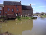
extraction still takes place along the valley's basin. At Cogenhoe
the river passes through a watermill
. The mill is a red brick building built in the late nineteenth century, with a slate roof, from which all the machinery has been removed. Adjacent is a Mill House, built of coursed limestone rubble, and dated 1725. At Earls Barton
the river again passes an area of mature gravel pit lakes and lock gates numbers 9 and 10. Further on the river passes through Doddington Lock No 11 and the nearby Hardwater Watermill. This watermill, mentioned in the Domesday Book
, has ground wheat into flour for almost 1000 years. Thomas à Beckett
, Archbishop of Canterbury
, used the mill as a hiding place after escaping from Northampton Castle
in 1164 and fleeing down the Nene to be sheltered by the miller before fleeing to France. The watermill ceased grinding flour after the Second World War. The present buildings date from the late eighteenth and early nineteenth centuries, and have been converted into dwellings.
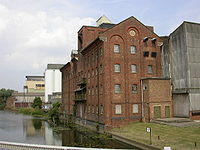 The river's course turns north easterly, passing the town of Wellingborough
on its north bank and the village of Little Irchester
to the south. At Wellingborough the river passes through Victoria Mills. Founded in 1886 by the Whitworth family, they are still run by the firm today, producing fine flours for the bakery trade. In front of the mill there remains a jetty from the days when the river was used for transportation of goods to and from the mills. A little further on the river is joined from the north by the River Ise
. On the opposite bank are the remains of the roman town of Irchester
. The river now passes under a viaduct that carries the Midland Main Line
which links London
St. Pancras International to Sheffield
Midland station
in northern England
via Luton
, Bedford, Kettering
, Leicester
, Derby
, Nottingham
and Chesterfield
.
Passing Irthlingborough
on its north western bank, the Nene now flows past Nene Park
, the former ground of Rushden and Diamonds Football Club, now occupied by Kettering Town Football Club. Further on the river is crossed by the disused track bed of the London & Birmingham Railway (L&BR) which was constructed in 1845. The river is now characterised by large curving meanders passing the villages of Little Addington Great Addington
and Denford.
 At Denford the river divides into two channels, one of which is used for navigation. The channels approach the town of Thrapston
, passing under two adjacent viaducts. One carries the busy A14 trunk road; the other carries the disused railway track bed. Between the town of Thrapston and the village of Islip
, the Nene is spanned by a low nine-arched bridge. Just north of Thrapston the river forms part of the 73 hectares (180.4 acre) of Titchmarsh
Nature Reserve. The reserve, designated in 1989, consists of two lakes, a woodland, river banks and areas of grass and scrub in which some ponds have been dug. The reserve is operated by Northamptonshire County Council
, with the approval of the Nature Conservancy Council
. At Aldwincle
another tributary, called Harpers Brook
, joins the Nene from the north west. Harpers Brook flows between gravel pit lagoons before converging with the river. The river flows south of Oundle
passing Barnwell Country Park and Oundle Marina under a bridge of the A605 road
. At , the Romans
bridge
d the river with Ermine Street
in the first century.
and through the Nene Valley Country Park. Half a mile upstream of the city centre is Woodston Wharf—the site of the old sea lock—originally the extent of the tidal River Nene until the Dog in a Doublet lock at Whittlesey
was opened in 1937. Below Peterborough, the river forms the border between Cambridgeshire and Norfolk
for about 3.7 miles (6 km).
Continuing downstream leads to the impressive 'Embankment' area and after the cathedral
city itself, passing through Benwick
the landscape changes to the Nene Washes
in The Fens
and their vast horizons. Beyond Flag Fen
the river flows through Wisbech
, then Sutton Bridge
in Lincolnshire
, and it finally enters The Wash
between two towers known as "the lighthouses".
The Nene links the Grand Union Canal
to the River Great Ouse
, via the Middle Level Navigations
. Much of its route has been upgraded to a wide canal with locks at regular intervals. Some sections where artificial cuts run adjacent to the course of the river are known as the "Nene Navigation".
usually ˈniːn (rhyming with "mean"). The spelling was "Nenn" (as seen in Cole-Roper's 1810 engraving) or "Nyn" until the beginning of the 20th century, and the point at which the pronunciation changes has been moving further inland for many years; the current edition of the Imray "Map Of The River Nene" suggests that the cut-off point is Thrapston
.
There is no certain etymology for the name. It has been suggested that it is Celtic: certainly many major rivers in England show pre-Anglo-Saxon origins, such as the Ouse and Avon; the same name appears in the 'Neen', the former name of the river Rea in Shropshire, which is retained in the hamlet of Neen Savage
. A.D. Mills however considers the name 'obscure' and suggests that it may even be pre-Celtic.
The river gave its name to the former Nene College of Higher Education in Northampton
, now the University of Northampton
, and also to the Rolls-Royce Nene
turbojet engine, Rolls-Royce
's practice being to name their gas turbine
designs after British rivers. This may also be linked to the fact that Sir Henry Royce
was born in Alwalton
, a village which is by the river Nene near Peterborough.
was obtained in 1713, which appointed large numbers of Commissioners, but stated that work could only proceed if any nine of them could find someone to make the entire river navigable. No-one was prepared to take on the task, although it appears from the Act that the river was navigable from Peterborough to Alwalton at the time. The Act was superseded by a second one obtained in 1724, which allowed the river to be improved in stages, the work to be carried out at the contractor's expense, with the cost to be recouped from tolls. Robert Wright and Thomas Squire agreed to these terms for the section from Peterborough to the bridge at Oundle North in September 1726, and completed the work by 1730. Squire then agreed to the same terms for the next section to Thrapston in 1736, and completed it by late 1737. This part of the river was then designated as the Eastern Division.
A failure to find anyone prepared to work on the Western Division from Thrapston to Northampton resulted in a third Act being obtained in 1756, which allowed the Commissioners to borrow money to finance the work. Lenders would become Proprietors of the Navigation, and the work was to begin at Thrapston and extend the navigable section towards Northampton. It took the Commissioners two years to agree who should carry out the work, but on 22 June 1758, John Smith jnr from Attercliffe, Yorkshire was contracted to construct 20 pound locks, 20 horse haling bridges and various other works at a cost of £14,070. The river opened to navigation in stages over the next three years, with a great celebration being held at Northampton on 7 August 1761 when the work was completed.
The proprietors had the right to use tolls as they saw fit, and the Commissioners found that they had no powers to ensure the navigation was maintained in good order. They obtained another Act of Parliament in 1794, which aimed to rectify the situation, but it was not until 1801 that Thomas Wright replied to their requests, and some repairs were made. There was little traffic and income from tolls was low, at just £488 per year between 1801 and 1804. The Commissioners were also keen to see a link constructed from Northampton to the Grand Junction Canal
, but the canal company argued that there was an insufficient supply of water. It was agreed that a link would be built in two halves, but that there would be 1 miles (1.6 km) of railway in the middle. When built, the canal company constructed the entire link as a railway, which opened in 1805. In a bid to get a navigable link, the Commissioners opposed the bill to build a link between the Grand Junction Canal and the Old Union Canal, but relented when they had a firm agreement that a navigable link to Northampton would be built. The link cost £35,000, was supervised by Benjamin Bevan, and was built between 1812 and 1815. It was nearly 5 miles (8 km) long, and dropped 107 feet (32.6 m) through 17 locks.
Tolls rose to a little over £1,000 per year, but the Commissioners decided that the canal boats damaged the locks, and all traffic had to be transferred to river barges. This order was withdrawn in 1827, but the condition of the river gradually deteriorated, and the arrival of the Blisworth to Peterborough Railway in 1845 further reduced profitability. Flooding was also a problem, but the Commissioners had no powers to act as Commissioners of Sewers, to address the problems of drainage. With serious flooding in December 1848, a public meeting was held, and a committee was elected to consider Nene drainage. The main problem was a restriction at Wisbech, and the engineer James Rendel estimated that £120,000 was required to reconstruct the river below Peterborough. The Nene Valley Drainage and Improvement Act was obtained in 1852, to allow this work to be completed.
. Once the latter was diverted to King's Lynn
in 1236, the Nene outfall deteriorated. Navigation was improved in the 1470s when Morton's Leam, a straight channel between Peterborough and Wisbech, was constructed by Bishop Morton. It was improved in 1570 and 1631, and was largely superseded by Smith's Leam, a straight cut from Peterborough to Guyhirne made by the Bedford Level Corporation in 1728. In order to improve the mouth of the river, which followed a tortuous route through salt marshes, the construction of a new channel was proposed by Nathaniel Kinderley, and work started on it in 1721. It was nearly completed when Wisbech Corporation's support turned to opposition, and they destroyed the work. The cut was eventually completed in 1773, but was not long enough to be a complete success.
Various proposals for improvements near Wisbech were made, notably in 1814 by John Rennie and again in 1821 by Thomas Telford
, but all were opposed by Wisbech Corporation. An Act of Parliament was obtained in 1827 to enable the works and Wisbech contributed £30,000 to the project. The contractors for the new cut below Wisbech were Jolliffe and Banks, who charged £149,259 for the channel. Once the old channel was dammed up, the tidal scour in the new channel was sufficient to remove silt deposits, and large volumes of stone were needed to stabilise the banks. The effects on the port of Wisbech were immediate, with tonnage rising from 63,180 tons in 1830 to 159,678 tons in 1845.
The 1852 Drainage and Improvement Act gave the Commissioners wide powers to manage the river, but created an administrative structure that was too complex to be workable. With the river in a poor state, James Rendel was appointed as engineer, and began dredging the channel and raising the banks, which cost £124,000. Another Act of Parliament was obtained in 1854, to allow the Commissioners to borrow £325,000 to pay for the work. A new iron swing bridge was built in Wisbech, to replace a narrow stone bridge which restricted the flow of the river, and although it was tested on installation, it was not operated subsequently. Dams across the river were built at Waldersea and Guyhirne, and an underwater weir was constructed below the bridge at Wisbech. Wisbech Corporation took the Commissioners to court in 1859 for obstructing the river, and when an initial judgement was made in their favour, gangs of men destroyed most of the Waldersea dam overnight. An appeal to the Court of Chancery by the Commissioners also failed, and the dams were removed, as was the Wisbech weir, after an accident involving a train of lighters.
Navigation was always hampered by the Northey Gravel shoal near Dog-in-a-Doublet. Together with a sluice, this prevented salt water from entering the Thorney River, and the Duke of Bedford had obtained an injunction in 1865 to prevent interference with it. An appeal to have the injunction removed in 1880 failed. A dock covering 13 acres (5.3 ha) was built at Sutton Bridge at this time, but the outer wall collapsed on 9 June 1881, a few days before it was officially opened, and the estimated repair costs of £160,000 resulted in the project failing. Sporadic traffic managed to use the river, but its condition continued to deteriorate.
The new locks resulted in some commercial traffic returning to the river. The port of Wisbech can handle ships up to 260 by long and with a draught of 17 feet (5.2 m), and remains a commercial port in 2009. It also caters for smaller boats, with a major expansion of the facilities at the yacht harbour completed in May 2000.
Traditionally the guillotines were manually operated by turning a large wheel some 150 times to raise or lower the gate; since the locks have to be left empty this operation will always have to be done twice to pass through. In recent years the Environment Agency, who are the navigation authority for the river, have been installing electric operation of the guillotines and in some cases replacing them altogether with mitre gates.
. On Good Friday
, 10 April 1998, the floods peaked and many rivers burst their banks. The Nene was badly affected, flooding low-lying parts of Northampton, Wellingborough and the surrounding villages. The town centre of Northampton lies on the northern slope of the Nene Valley and escapes the river's flooding. However, the Far Cotton and St. James areas of the town occupy the flood plain and have borne the brunt of severe flooding over the years, culminating in the 1998 Easter floods. In 2002, a siren warning system was installed in Northampton to warn residents in the event of further flooding, and embankments and flood walls were bolstered to protect the town. In Kislingbury
village, a flood alleviation scheme was completed in 2004.
In 2007, the British Government announced it would spend £6 million on flood defences at Upton Mill in the west of Northampton; wetland areas and embankments were to be constructed along the river.
River
A river is a natural watercourse, usually freshwater, flowing towards an ocean, a lake, a sea, or another river. In a few cases, a river simply flows into the ground or dries up completely before reaching another body of water. Small rivers may also be called by several other names, including...
in the east of England that rises from three sources in the county of Northamptonshire
Northamptonshire
Northamptonshire is a landlocked county in the English East Midlands, with a population of 629,676 as at the 2001 census. It has boundaries with the ceremonial counties of Warwickshire to the west, Leicestershire and Rutland to the north, Cambridgeshire to the east, Bedfordshire to the south-east,...
. The tidal river
Tidal river
A tidal river is a river, or more typically a stretch of a river, whose flow and level is influenced by tides. An example of a tidal river is the portion of the Connecticut River flowing from Windsor Locks, Connecticut, to the Atlantic Ocean. The Brisbane River, which flows into the Pacific Ocean...
forms the border between Cambridgeshire and Norfolk
Norfolk
Norfolk is a low-lying county in the East of England. It has borders with Lincolnshire to the west, Cambridgeshire to the west and southwest and Suffolk to the south. Its northern and eastern boundaries are the North Sea coast and to the north-west the county is bordered by The Wash. The county...
for about 3.7 miles (6 km). It is the tenth longest river in the United Kingdom
United Kingdom
The United Kingdom of Great Britain and Northern IrelandIn the United Kingdom and Dependencies, other languages have been officially recognised as legitimate autochthonous languages under the European Charter for Regional or Minority Languages...
, and is navigable for 88 miles (141.6 km) from Northampton
Northampton
Northampton is a large market town and local government district in the East Midlands region of England. Situated about north-west of London and around south-east of Birmingham, Northampton lies on the River Nene and is the county town of Northamptonshire. The demonym of Northampton is...
to The Wash
The Wash
The Wash is the square-mouthed bay and estuary on the northwest margin of East Anglia on the east coast of England, where Norfolk meets Lincolnshire. It is among the largest estuaries in the United Kingdom...
.
Course
The River Nene is the tenth longest river in the United KingdomUnited Kingdom
The United Kingdom of Great Britain and Northern IrelandIn the United Kingdom and Dependencies, other languages have been officially recognised as legitimate autochthonous languages under the European Charter for Regional or Minority Languages...
. From its source at Arbury Hill
Arbury Hill
Arbury Hill, at 225 m , is the highest point in the English county of Northamptonshire.It is southwest of the town of Daventry. The River Nene rises nearby.-Earthworks:...
to Northampton
Northampton
Northampton is a large market town and local government district in the East Midlands region of England. Situated about north-west of London and around south-east of Birmingham, Northampton lies on the River Nene and is the county town of Northamptonshire. The demonym of Northampton is...
the river falls a total of 300 feet (91.4 m) in 17 miles (27.4 km). For the remainder of its course, the Nene falls less than 200 feet (61 m). It has a catchment area of 631 square miles (1,634.3 km²) and a mean flow of 328 cubic feet (9.3 m³) per second. The final 88 miles (141.6 km) from Northampton to the Wash is navigable.
The river's most westerly source can be found near the village of Badby
Badby
Badby is a village and a rural parish of about in the Daventry district of the county of Northamptonshire, England.-Location:Badby is about south of Daventry, on the A361 Daventry to Banbury road. It is bisected west to east, at about above sea level, by the upper reaches of the River Nene...
near Daventry
Daventry
Daventry is a market town in Northamptonshire, England, with a population of 22,367 .-Geography:The town is also the administrative centre of the larger Daventry district, which has a population of 71,838. The town is 77 miles north-northwest of London, 13.9 miles west of Northampton and 10.2...
. On the eastern slope of Arbury Hill
Arbury Hill
Arbury Hill, at 225 m , is the highest point in the English county of Northamptonshire.It is southwest of the town of Daventry. The River Nene rises nearby.-Earthworks:...
and in pools between Arbury Hill and Sharmans Hill there are three tributaries that converge at Dodford
Dodford, Northamptonshire
Dodford is a village in the county of Northamptonshire, England, within the Weedon Ward of Daventry District. The village is just north of the A45 road 1½ miles west of Weedon. It is 3½ miles east of Daventry and ten miles west of Northampton. It is also close to junction 16 of the M1 motorway...
mill to form the upper reaches of the Daventry
Daventry
Daventry is a market town in Northamptonshire, England, with a population of 22,367 .-Geography:The town is also the administrative centre of the larger Daventry district, which has a population of 71,838. The town is 77 miles north-northwest of London, 13.9 miles west of Northampton and 10.2...
Nene. The two northern streams flow through the villages of Badby
Badby
Badby is a village and a rural parish of about in the Daventry district of the county of Northamptonshire, England.-Location:Badby is about south of Daventry, on the A361 Daventry to Banbury road. It is bisected west to east, at about above sea level, by the upper reaches of the River Nene...
and Newnham
Newnham, Northamptonshire
Newnham is a village in the Daventry district of the county of Northamptonshire in England. The village is south of Daventry, west from Weedon Bec, west of junction 16 of the M1 motorway and west of Northampton. The A45 road runs a mile northwest of the village...
to the convergence, whilst the southerly stream runs through Fawsley Park and through the village of Everdon
Everdon
Everdon is a village in the Daventry district of the county of Northamptonshire in England some two miles south of Daventry.Nearby The Stubbs is a wood belonging to the Woodland Trust, a UK conservation charity...
before the convergence. From Dodford the river passes through the village of Weedon
Weedon Bec
Weedon Bec , usually just called "Weedon", is a large village and parish in the district of Daventry, Northamptonshire, England. It lies close to the source of the River Nene.-Geography:...
where it flows under the main west coast railway line
West Coast Main Line
The West Coast Main Line is the busiest mixed-traffic railway route in Britain, being the country's most important rail backbone in terms of population served. Fast, long-distance inter-city passenger services are provided between London, the West Midlands, the North West, North Wales and the...
and also under the Grand Union Canal
Grand Union Canal
The Grand Union Canal in England is part of the British canal system. Its main line connects London and Birmingham, stretching for 137 miles with 166 locks...
. A little west of Weedon the river converges with its tributary source from Yelvertoft
Yelvertoft
Yelvertoft is a village in the Daventry district of the county of Northamptonshire in England. At the time of the 2001 census, the parish's population was 821 people....
from the north. This tributary, the Yelvertoft Nene, is formed from a great many streams. The river now flows towards Northampton, passing through Flore and Nether Heyford
Nether Heyford
Nether Heyford is an English village west of Northampton off the A45 road, in the shire county of Northamptonshire, known as "Northants". It is by road to the M1 London to Yorkshire motorway junction 16, north of London and southeast of Birmingham...
, where it is joined by small streams on either bank. A little past Bugbrooke
Bugbrooke
Bugbrooke is a large village and civil parish in Northamptonshire, England, on a ridge overlooking the valley of the River Nene.-Location:It is about south west of Northampton...
Mill the Nene passes under the M1 motorway
M1 motorway
The M1 is a north–south motorway in England primarily connecting London to Leeds, where it joins the A1 near Aberford. While the M1 is considered to be the first inter-urban motorway to be completed in the United Kingdom, the first road to be built to motorway standard in the country was the...
and falls over a weir towards Kislingbury
Kislingbury
Kislingbury is a village in Northamptonshire, England, about west of Northampton town centre, and close to junctions 15A and 16 of the M1 motorway.-Demographics:...
.
Grand Union Canal
The Grand Union Canal in England is part of the British canal system. Its main line connects London and Birmingham, stretching for 137 miles with 166 locks...
’s Northampton arm at Upton Mill.
Northampton
At Upton Mill, another tributary, called Wooton BrookWooton Brook
Wootton Brook is a tributary of the River Nene which runs through Northamptonshire. The Brook joins the River Nene from the south at Upton Mill-References:...
, joins the river from the south.
The River Nene now approaches Northampton town from the west, passing between the southern suburbs of St. James (locally known as Jimmy's End) and Far Cotton
Far Cotton
Far Cotton, many years ago a village in its own right, is a district of the English county town of Northampton.Far Cotton is due south of the town centre, beyond Cotton End - hence the 'Far' - and south of the River Nene...
. The Nene’s third northern source, the Naseby
Naseby
Naseby is a small village in the District of Daventry in Northamptonshire, England.The village is 14 mi north of Northampton, 13.3 mi northeast of Daventry, and 7 mi south of Market Harborough. It is 2.4 mi from Junction 2 of the A14 road, giving it access to the national road system...
Source or Brampton Nene, converges at the Carlsberg Brewery. This tributary flows through the north of Northampton where several streams join. Three of these streams supply water for reservoirs at Pitsford
Pitsford Water
Pitsford Water is a reservoir in Northamptonshire, England. The reservoir was built in 1956 to supply the town of Northampton, which is about 6 miles to the south. The water is the third-largest in the United Kingdom, with a surface area of 2.85 square miles. Operated by Anglian Water, the...
, Hollowell
Hollowell
Hollowell is a village and civil parish in the Daventry district of the county of Northamptonshire in England. At the time of the 2001 census, the parish's population, including the nearby hamlet of Teeton, was 353 people.-Geography:...
and Ravensthorpe
Ravensthorpe, Northamptonshire
Ravensthorpe is a village and civil parish in the Daventry district of the county of Northamptonshire in England. The village lies approximately midway between Northampton and Rugby. The M1 motorway is six miles west and the nearest railway station is at Long Buckby...
, north of Northampton, before joining the Brampton Nene. At Cotton End, the Nene passes under South Bridge, then through Beckett's Park and past the disused and now demolished Northampton Power Station
Northampton Power Station
Northampton Power Station was a electricity generating station in Northampton, Northamptonshire, England, which began operation for the Northampton Electric Light and Power Company in the 1920s and generated power until closure in 1975.-Location:The plant was located on the south bank of the...
in the Nunn Mills area of the town on the south bank of the river opposite Midsummer Meadow on the north banks. The TS Laforey Sea Cadet unit is based in Nunn Mills, and uses the river for training in boating skills, following training schemes approved by the British Canoe Union
British Canoe Union
The British Canoe Union is a national governing body for canoeing in the United Kingdom, whose stated purpose is "Helping and Inspiring people to go canoeing”....
(BCU) and the Royal Yachting Association
Royal Yachting Association
The Royal Yachting Association is the national governing body for certain watersports in the United Kingdom. Activities it covers include:* Sailing* Windsurfing* Motor cruising* Sportsboats* Personal watercraft* Powerboat racing...
(RYA). A short way downstream a weir can divert some of the Nene's flow to supply the Nene Whitewater Centre
Nene Whitewater Centre
The Nene Whitewater Centre was the UK's first pumped artificial whitewater course. It is located on the River Nene in Northampton.The course was designed by slalom designers, Proper Channels Ltd and built in 1999 by Wrekin Construction. Water can be partially diverted around a weir via a manually...
.
The Nene Valley
From Northampton, the river flows along a broad valley, formed by the enormous amount of water released by the melting ice during the Ice Age, towards the east coast. The Nene now meanders through this wide, flat valley with flood plains, lakes, pools and mature gravel pits on either bank, a by-product of the large glacial deposits in the valley. At Great Billing is Billing AquadromeBilling Aquadrome
Billing Aquadrome is a leisure park in Great Billing, in the eastern district of Northampton, England. Facilities within the 235-acre park, which is based around various mature gravel pits, include a caravan site, marina and funfair...
, a popular caravan and camping park with leisure facilities and a funfair, which is based around the river and various mature gravel pits. The park is popular with fishermen and water skiers alike. The river's landscape is now dominated by mature gravel pit lakes. Some gravel
Gravel
Gravel is composed of unconsolidated rock fragments that have a general particle size range and include size classes from granule- to boulder-sized fragments. Gravel can be sub-categorized into granule and cobble...
extraction still takes place along the valley's basin. At Cogenhoe
Cogenhoe
Cogenhoe is a village in South Northamptonshire, England. The civil parish of Cogenhoe and Whiston had a population at the 2001 census of 1,439 ....
the river passes through a watermill
Watermill
A watermill is a structure that uses a water wheel or turbine to drive a mechanical process such as flour, lumber or textile production, or metal shaping .- History :...
. The mill is a red brick building built in the late nineteenth century, with a slate roof, from which all the machinery has been removed. Adjacent is a Mill House, built of coursed limestone rubble, and dated 1725. At Earls Barton
Earls Barton
Earls Barton is a village and civil parish in eastern Northamptonshire, notable for its Saxon church and shoe-making heritage.The village was the inspiration for the film Kinky Boots and part of the film was shot here...
the river again passes an area of mature gravel pit lakes and lock gates numbers 9 and 10. Further on the river passes through Doddington Lock No 11 and the nearby Hardwater Watermill. This watermill, mentioned in the Domesday Book
Domesday Book
Domesday Book , now held at The National Archives, Kew, Richmond upon Thames in South West London, is the record of the great survey of much of England and parts of Wales completed in 1086...
, has ground wheat into flour for almost 1000 years. Thomas à Beckett
Thomas à Beckett
Sir Thomas à Beckett was an Australian solicitor and judge.-Personal:Thomas à Beckett was born in London, England...
, Archbishop of Canterbury
Archbishop of Canterbury
The Archbishop of Canterbury is the senior bishop and principal leader of the Church of England, the symbolic head of the worldwide Anglican Communion, and the diocesan bishop of the Diocese of Canterbury. In his role as head of the Anglican Communion, the archbishop leads the third largest group...
, used the mill as a hiding place after escaping from Northampton Castle
Northampton Castle
Northampton Castle was built under the stewardship of Simon de Senlis, the first Earl of Northampton, in 1084. It took several years to complete, as there is no mention of it in the Domesday Book, a great survey of England completed in 1086....
in 1164 and fleeing down the Nene to be sheltered by the miller before fleeing to France. The watermill ceased grinding flour after the Second World War. The present buildings date from the late eighteenth and early nineteenth centuries, and have been converted into dwellings.
Wellingborough
Wellingborough
Wellingborough is a market town and borough in Northamptonshire, England, situated some from the county town of Northampton. The town is situated on the north side of the River Nene, most of the older town is sited on the flanks of the hills above the river's current flood plain...
on its north bank and the village of Little Irchester
Irchester
Irchester is a civil parish and village in the county of Northamptonshire, England. It is about 2 miles south-east of the town of Wellingborough and 2 miles south-west of Rushden, and equidistant from London, south, and Birmingham, to the north-west...
to the south. At Wellingborough the river passes through Victoria Mills. Founded in 1886 by the Whitworth family, they are still run by the firm today, producing fine flours for the bakery trade. In front of the mill there remains a jetty from the days when the river was used for transportation of goods to and from the mills. A little further on the river is joined from the north by the River Ise
River Ise
The River Ise is a river in Northamptonshire, England and a tributary of the River Nene.The river rises in the very field that hosted the Battle of Naseby at the north-western tip of Northamptonshire...
. On the opposite bank are the remains of the roman town of Irchester
Irchester
Irchester is a civil parish and village in the county of Northamptonshire, England. It is about 2 miles south-east of the town of Wellingborough and 2 miles south-west of Rushden, and equidistant from London, south, and Birmingham, to the north-west...
. The river now passes under a viaduct that carries the Midland Main Line
Midland Main Line
The Midland Main Line is a major railway route in the United Kingdom, part of the British railway system.The present-day line links London St...
which links London
London
London is the capital city of :England and the :United Kingdom, the largest metropolitan area in the United Kingdom, and the largest urban zone in the European Union by most measures. Located on the River Thames, London has been a major settlement for two millennia, its history going back to its...
St. Pancras International to Sheffield
Sheffield
Sheffield is a city and metropolitan borough of South Yorkshire, England. Its name derives from the River Sheaf, which runs through the city. Historically a part of the West Riding of Yorkshire, and with some of its southern suburbs annexed from Derbyshire, the city has grown from its largely...
Midland station
Sheffield Midland station
Sheffield station, formerly Pond Street and later Sheffield Midland, is a railway station in Sheffield, England and is the busiest station in South Yorkshire...
in northern England
England
England is a country that is part of the United Kingdom. It shares land borders with Scotland to the north and Wales to the west; the Irish Sea is to the north west, the Celtic Sea to the south west, with the North Sea to the east and the English Channel to the south separating it from continental...
via Luton
Luton
Luton is a large town and unitary authority of Bedfordshire, England, 30 miles north of London. Luton and its near neighbours, Dunstable and Houghton Regis, form the Luton/Dunstable Urban Area with a population of about 250,000....
, Bedford, Kettering
Kettering
Kettering is a market town in the Borough of Kettering, Northamptonshire, England. It is situated about from London. Kettering is mainly situated on the west side of the River Ise, a tributary of the River Nene which meets at Wellingborough...
, Leicester
Leicester
Leicester is a city and unitary authority in the East Midlands of England, and the county town of Leicestershire. The city lies on the River Soar and at the edge of the National Forest...
, Derby
Derby
Derby , is a city and unitary authority in the East Midlands region of England. It lies upon the banks of the River Derwent and is located in the south of the ceremonial county of Derbyshire. In the 2001 census, the population of the city was 233,700, whilst that of the Derby Urban Area was 229,407...
, Nottingham
Nottingham
Nottingham is a city and unitary authority in the East Midlands of England. It is located in the ceremonial county of Nottinghamshire and represents one of eight members of the English Core Cities Group...
and Chesterfield
Chesterfield
Chesterfield is a market town and a borough of Derbyshire, England. It lies north of Derby, on a confluence of the rivers Rother and Hipper. Its population is 70,260 , making it Derbyshire's largest town...
.
Passing Irthlingborough
Irthlingborough
Irthlingborough , originally called Artleborough, is a small town on the River Nene in Northamptonshire, England with a population of 6,179 people according to the 2001 census. It is the smallest town in England to have possessed a league association football team, Rushden & Diamonds. The parish...
on its north western bank, the Nene now flows past Nene Park
Nene Park
Nene Park is a football stadium situated by Irthlingborough, Northamptonshire, England, along the bank of the River Nene, and holds 6,441, with 4,641 seated and 1,800 standing. The car park can hold 800 vehicles. From 1992 until 2011 it was the home ground of Rushden & Diamonds football club...
, the former ground of Rushden and Diamonds Football Club, now occupied by Kettering Town Football Club. Further on the river is crossed by the disused track bed of the London & Birmingham Railway (L&BR) which was constructed in 1845. The river is now characterised by large curving meanders passing the villages of Little Addington Great Addington
Great Addington
Great Addington is a small village and civil parish in Northamptonshire, England. It lies near the west bank of the River Nene, about 5 miles east of Kettering. It consists of approximately 100 houses; at the time of the 2001 census, the population of the parish was 319 people...
and Denford.
Thrapston
Thrapston
Thrapston is a small town in Northamptonshire, England. It is the headquarters of the East Northamptonshire district, and in 2001 had a population of 4,855. By 2006, this was estimated to be over 5,700....
, passing under two adjacent viaducts. One carries the busy A14 trunk road; the other carries the disused railway track bed. Between the town of Thrapston and the village of Islip
Islip, Northamptonshire
Islip is a village and civil parish in East Northamptonshire, England. It is close to the town of Thrapston, 5 miles from Little Addington and 7 miles east of Kettering. At the time of the 2001 census, the parish's population was 763 people. Islip is linked to Corby which is 10 miles north-west...
, the Nene is spanned by a low nine-arched bridge. Just north of Thrapston the river forms part of the 73 hectares (180.4 acre) of Titchmarsh
Titchmarsh, Northamptonshire
Titchmarsh is a village and civil parish in East Northamptonshire, England. At the time of the 2001 census, the parish's population was 543 people....
Nature Reserve. The reserve, designated in 1989, consists of two lakes, a woodland, river banks and areas of grass and scrub in which some ponds have been dug. The reserve is operated by Northamptonshire County Council
Northamptonshire
Northamptonshire is a landlocked county in the English East Midlands, with a population of 629,676 as at the 2001 census. It has boundaries with the ceremonial counties of Warwickshire to the west, Leicestershire and Rutland to the north, Cambridgeshire to the east, Bedfordshire to the south-east,...
, with the approval of the Nature Conservancy Council
Nature Conservancy Council
The Nature Conservancy Council was a United Kingdom government agency responsible for designating and managing National Nature Reserves and other nature conservation areas in Great Britain between 1973 and 1991 ....
. At Aldwincle
Aldwincle
Aldwincle is a village in the east of the county of Northamptonshire, England. It is on a bend of the River Nene not far from Thrapston.In 1879, two ecclesiastical parishes, Aldwinkle All Saints and Aldwinkle St Peter merged after the parish church of the former was declared redundant in 1971 and...
another tributary, called Harpers Brook
Harpers Brook
Harpers Brook is a tributary of the river Nene which runs through Northamptonshire.According to sources it originates close to the Leicestershire town of Market Harborough and meanders through the north of the county of Northamptonshire, passing through the town of Corby and on until it joins the...
, joins the Nene from the north west. Harpers Brook flows between gravel pit lagoons before converging with the river. The river flows south of Oundle
Oundle
Oundle is an ancient market town on the River Nene in Northamptonshire, England, with a population of 5,345 or 5,674 . It lies some north of London and south-west of Peterborough...
passing Barnwell Country Park and Oundle Marina under a bridge of the A605 road
A605 road
The A605 road is a main road in the English counties of Northamptonshire and Cambridgeshire.-Route :The A605 strikes north from junction 13 of the trunk A14 road through the eastern parts of Thrapston, skirts the village of Thorpe Waterville, bypasses Oundle to its east, crosses the River Nene,...
. At , the Romans
Roman Britain
Roman Britain was the part of the island of Great Britain controlled by the Roman Empire from AD 43 until ca. AD 410.The Romans referred to the imperial province as Britannia, which eventually comprised all of the island of Great Britain south of the fluid frontier with Caledonia...
bridge
Bridge
A bridge is a structure built to span physical obstacles such as a body of water, valley, or road, for the purpose of providing passage over the obstacle...
d the river with Ermine Street
Ermine Street
Ermine Street is the name of a major Roman road in England that ran from London to Lincoln and York . The Old English name was 'Earninga Straete' , named after a tribe called the Earningas, who inhabited a district later known as Armingford Hundred, around Arrington, Cambridgeshire and Royston,...
in the first century.
Peterborough
Having passed among the gentle hills of Northamptonshire the river enters the rural part of the City of Peterborough, passing the Nene Valley RailwayNene Valley Railway
The Nene Valley Railway is a preserved railway in Cambridgeshire, England, running between Peterborough Nene Valley and Yarwell Junction. The line is currently seven and a half miles in length...
and through the Nene Valley Country Park. Half a mile upstream of the city centre is Woodston Wharf—the site of the old sea lock—originally the extent of the tidal River Nene until the Dog in a Doublet lock at Whittlesey
Whittlesey
Whittlesey, historically known as Whittlesea as the name of the railway station is still spelt, or Witesie, is an ancient Fenland market town around six miles east of Peterborough in the county of Cambridgeshire in England...
was opened in 1937. Below Peterborough, the river forms the border between Cambridgeshire and Norfolk
Norfolk
Norfolk is a low-lying county in the East of England. It has borders with Lincolnshire to the west, Cambridgeshire to the west and southwest and Suffolk to the south. Its northern and eastern boundaries are the North Sea coast and to the north-west the county is bordered by The Wash. The county...
for about 3.7 miles (6 km).
Continuing downstream leads to the impressive 'Embankment' area and after the cathedral
Cathedral
A cathedral is a Christian church that contains the seat of a bishop...
city itself, passing through Benwick
Benwick
Benwick is a village and civil parish in the Fenland district of Cambridgeshire, England. It is approximately from Peterborough and from Cambridge...
the landscape changes to the Nene Washes
Nene Washes
The Nene Washes are a Special Protection Area along the River Nene in the English county of Cambridgeshire.They extend for around east of the City of Peterborough and cover more than...
in The Fens
The Fens
The Fens, also known as the , are a naturally marshy region in eastern England. Most of the fens were drained several centuries ago, resulting in a flat, damp, low-lying agricultural region....
and their vast horizons. Beyond Flag Fen
Flag Fen
Flag Fen near Peterborough, England is a Bronze Age site, probably religious. It comprises over 60,000 timbers arranged in five very long rows connecting Whittlesey Island with Peterborough across the wet fenland. Part way across the structure, a small island was formed which is where it is...
the river flows through Wisbech
Wisbech
Wisbech is a market town, inland port and civil parish with a population of 20,200 in the Fens of Cambridgeshire. The tidal River Nene runs through the centre of the town and is spanned by two bridges...
, then Sutton Bridge
Sutton Bridge
Sutton Bridge is a village and civil parish in southeastern Lincolnshire, England on the west bank of the River Nene in the district of South Holland.-Geography:...
in Lincolnshire
Lincolnshire
Lincolnshire is a county in the east of England. It borders Norfolk to the south east, Cambridgeshire to the south, Rutland to the south west, Leicestershire and Nottinghamshire to the west, South Yorkshire to the north west, and the East Riding of Yorkshire to the north. It also borders...
, and it finally enters The Wash
The Wash
The Wash is the square-mouthed bay and estuary on the northwest margin of East Anglia on the east coast of England, where Norfolk meets Lincolnshire. It is among the largest estuaries in the United Kingdom...
between two towers known as "the lighthouses".
The Nene links the Grand Union Canal
Grand Union Canal
The Grand Union Canal in England is part of the British canal system. Its main line connects London and Birmingham, stretching for 137 miles with 166 locks...
to the River Great Ouse
River Great Ouse
The Great Ouse is a river in the east of England. At long, it is the fourth-longest river in the United Kingdom. The river has been important for navigation, and for draining the low-lying region through which it flows. Its course has been modified several times, with the first recorded being in...
, via the Middle Level Navigations
Middle Level Navigations
The Middle Level Navigations are a network of waterways in England, primarily used for land drainage, between the Rivers Nene and Great Ouse, between Peterborough and Cambridge.- History :...
. Much of its route has been upgraded to a wide canal with locks at regular intervals. Some sections where artificial cuts run adjacent to the course of the river are known as the "Nene Navigation".
Origins of the Name
Pronunciation of the river's name varies with the locality. In Northamptonshire it is usually ˈnɛn (rhyming with "hen"), and around PeterboroughPeterborough
Peterborough is a cathedral city and unitary authority area in the East of England, with an estimated population of in June 2007. For ceremonial purposes it is in the county of Cambridgeshire. Situated north of London, the city stands on the River Nene which flows into the North Sea...
usually ˈniːn (rhyming with "mean"). The spelling was "Nenn" (as seen in Cole-Roper's 1810 engraving) or "Nyn" until the beginning of the 20th century, and the point at which the pronunciation changes has been moving further inland for many years; the current edition of the Imray "Map Of The River Nene" suggests that the cut-off point is Thrapston
Thrapston
Thrapston is a small town in Northamptonshire, England. It is the headquarters of the East Northamptonshire district, and in 2001 had a population of 4,855. By 2006, this was estimated to be over 5,700....
.
There is no certain etymology for the name. It has been suggested that it is Celtic: certainly many major rivers in England show pre-Anglo-Saxon origins, such as the Ouse and Avon; the same name appears in the 'Neen', the former name of the river Rea in Shropshire, which is retained in the hamlet of Neen Savage
Neen Savage
Neen Savage is a civil parish and a hamlet in south east Shropshire, England. It is situated north of the small market town of Cleobury Mortimer. The River Rea, which was historically known as the River Neen, flows past the hamlet and a notable ford exists....
. A.D. Mills however considers the name 'obscure' and suggests that it may even be pre-Celtic.
The river gave its name to the former Nene College of Higher Education in Northampton
Northampton
Northampton is a large market town and local government district in the East Midlands region of England. Situated about north-west of London and around south-east of Birmingham, Northampton lies on the River Nene and is the county town of Northamptonshire. The demonym of Northampton is...
, now the University of Northampton
University of Northampton
The University of Northampton is a university in Northampton, Northamptonshire, England.-History:In 1924, Northampton Technical College was opened at St George's Avenue, site of the current Avenue Campus. A new building for the college was formally opened by the then Duke and Duchess of York in 1932...
, and also to the Rolls-Royce Nene
Rolls-Royce Nene
|-See also:-References:NotesBibliography* Bridgman, L, Jane's fighting aircraft of World War II. Crescent. ISBN 0-517-67964-7-External links:* *...
turbojet engine, Rolls-Royce
Rolls-Royce plc
Rolls-Royce Group plc is a global power systems company headquartered in the City of Westminster, London, United Kingdom. It is the world’s second-largest maker of aircraft engines , and also has major businesses in the marine propulsion and energy sectors. Through its defence-related activities...
's practice being to name their gas turbine
Gas turbine
A gas turbine, also called a combustion turbine, is a type of internal combustion engine. It has an upstream rotating compressor coupled to a downstream turbine, and a combustion chamber in-between....
designs after British rivers. This may also be linked to the fact that Sir Henry Royce
Henry Royce
Sir Frederick Henry Royce, 1st Baronet, OBE was a pioneering car manufacturer, who with Charles Stewart Rolls founded the Rolls-Royce company.-Early life:...
was born in Alwalton
Alwalton
Alwalton is a village in Huntingdonshire in the United Kingdom, five miles to the west of the city of Peterborough....
, a village which is by the river Nene near Peterborough.
Navigation
The Nene is navigable from just above its junction with the Northampton Arm of the Grand Union Canal to the sea. Most leisure use is between Northampton and Peterborough, where it makes a junction with the Middle Level Navigations at Stanground Sluice, which give access to the Bedfordshire River Ouse. There is no longer any significant commercial traffic.Above Peterborough
The first recorded attempts to improve the upper river for navigation occurred in 1567 and 1606, when the people of Northampton commissioned surveys. In 1653, a printed pamphlet suggested that 33 locks to bypass the mills could be built for £8,000, to make the river navigable. Eventually, an Act of ParliamentAct of Parliament
An Act of Parliament is a statute enacted as primary legislation by a national or sub-national parliament. In the Republic of Ireland the term Act of the Oireachtas is used, and in the United States the term Act of Congress is used.In Commonwealth countries, the term is used both in a narrow...
was obtained in 1713, which appointed large numbers of Commissioners, but stated that work could only proceed if any nine of them could find someone to make the entire river navigable. No-one was prepared to take on the task, although it appears from the Act that the river was navigable from Peterborough to Alwalton at the time. The Act was superseded by a second one obtained in 1724, which allowed the river to be improved in stages, the work to be carried out at the contractor's expense, with the cost to be recouped from tolls. Robert Wright and Thomas Squire agreed to these terms for the section from Peterborough to the bridge at Oundle North in September 1726, and completed the work by 1730. Squire then agreed to the same terms for the next section to Thrapston in 1736, and completed it by late 1737. This part of the river was then designated as the Eastern Division.
A failure to find anyone prepared to work on the Western Division from Thrapston to Northampton resulted in a third Act being obtained in 1756, which allowed the Commissioners to borrow money to finance the work. Lenders would become Proprietors of the Navigation, and the work was to begin at Thrapston and extend the navigable section towards Northampton. It took the Commissioners two years to agree who should carry out the work, but on 22 June 1758, John Smith jnr from Attercliffe, Yorkshire was contracted to construct 20 pound locks, 20 horse haling bridges and various other works at a cost of £14,070. The river opened to navigation in stages over the next three years, with a great celebration being held at Northampton on 7 August 1761 when the work was completed.
The proprietors had the right to use tolls as they saw fit, and the Commissioners found that they had no powers to ensure the navigation was maintained in good order. They obtained another Act of Parliament in 1794, which aimed to rectify the situation, but it was not until 1801 that Thomas Wright replied to their requests, and some repairs were made. There was little traffic and income from tolls was low, at just £488 per year between 1801 and 1804. The Commissioners were also keen to see a link constructed from Northampton to the Grand Junction Canal
Grand Junction Canal
The Grand Junction Canal is a canal in England from Braunston in Northamptonshire to the River Thames at Brentford, with a number of branches. The mainline was built between 1793 and 1805, to improve the route from the Midlands to London, by-passing the upper reaches of the River Thames near Oxford...
, but the canal company argued that there was an insufficient supply of water. It was agreed that a link would be built in two halves, but that there would be 1 miles (1.6 km) of railway in the middle. When built, the canal company constructed the entire link as a railway, which opened in 1805. In a bid to get a navigable link, the Commissioners opposed the bill to build a link between the Grand Junction Canal and the Old Union Canal, but relented when they had a firm agreement that a navigable link to Northampton would be built. The link cost £35,000, was supervised by Benjamin Bevan, and was built between 1812 and 1815. It was nearly 5 miles (8 km) long, and dropped 107 feet (32.6 m) through 17 locks.
Tolls rose to a little over £1,000 per year, but the Commissioners decided that the canal boats damaged the locks, and all traffic had to be transferred to river barges. This order was withdrawn in 1827, but the condition of the river gradually deteriorated, and the arrival of the Blisworth to Peterborough Railway in 1845 further reduced profitability. Flooding was also a problem, but the Commissioners had no powers to act as Commissioners of Sewers, to address the problems of drainage. With serious flooding in December 1848, a public meeting was held, and a committee was elected to consider Nene drainage. The main problem was a restriction at Wisbech, and the engineer James Rendel estimated that £120,000 was required to reconstruct the river below Peterborough. The Nene Valley Drainage and Improvement Act was obtained in 1852, to allow this work to be completed.
Below Peterborough
Below Peterborough, the river meandered to Tydd Gote, where it shared an outfall to the Wash with the River Great OuseRiver Great Ouse
The Great Ouse is a river in the east of England. At long, it is the fourth-longest river in the United Kingdom. The river has been important for navigation, and for draining the low-lying region through which it flows. Its course has been modified several times, with the first recorded being in...
. Once the latter was diverted to King's Lynn
King's Lynn
King's Lynn is a sea port and market town in the ceremonial county of Norfolk in the East of England. It is situated north of London and west of Norwich. The population of the town is 42,800....
in 1236, the Nene outfall deteriorated. Navigation was improved in the 1470s when Morton's Leam, a straight channel between Peterborough and Wisbech, was constructed by Bishop Morton. It was improved in 1570 and 1631, and was largely superseded by Smith's Leam, a straight cut from Peterborough to Guyhirne made by the Bedford Level Corporation in 1728. In order to improve the mouth of the river, which followed a tortuous route through salt marshes, the construction of a new channel was proposed by Nathaniel Kinderley, and work started on it in 1721. It was nearly completed when Wisbech Corporation's support turned to opposition, and they destroyed the work. The cut was eventually completed in 1773, but was not long enough to be a complete success.
Various proposals for improvements near Wisbech were made, notably in 1814 by John Rennie and again in 1821 by Thomas Telford
Thomas Telford
Thomas Telford FRS, FRSE was a Scottish civil engineer, architect and stonemason, and a noted road, bridge and canal builder.-Early career:...
, but all were opposed by Wisbech Corporation. An Act of Parliament was obtained in 1827 to enable the works and Wisbech contributed £30,000 to the project. The contractors for the new cut below Wisbech were Jolliffe and Banks, who charged £149,259 for the channel. Once the old channel was dammed up, the tidal scour in the new channel was sufficient to remove silt deposits, and large volumes of stone were needed to stabilise the banks. The effects on the port of Wisbech were immediate, with tonnage rising from 63,180 tons in 1830 to 159,678 tons in 1845.
The 1852 Drainage and Improvement Act gave the Commissioners wide powers to manage the river, but created an administrative structure that was too complex to be workable. With the river in a poor state, James Rendel was appointed as engineer, and began dredging the channel and raising the banks, which cost £124,000. Another Act of Parliament was obtained in 1854, to allow the Commissioners to borrow £325,000 to pay for the work. A new iron swing bridge was built in Wisbech, to replace a narrow stone bridge which restricted the flow of the river, and although it was tested on installation, it was not operated subsequently. Dams across the river were built at Waldersea and Guyhirne, and an underwater weir was constructed below the bridge at Wisbech. Wisbech Corporation took the Commissioners to court in 1859 for obstructing the river, and when an initial judgement was made in their favour, gangs of men destroyed most of the Waldersea dam overnight. An appeal to the Court of Chancery by the Commissioners also failed, and the dams were removed, as was the Wisbech weir, after an accident involving a train of lighters.
Navigation was always hampered by the Northey Gravel shoal near Dog-in-a-Doublet. Together with a sluice, this prevented salt water from entering the Thorney River, and the Duke of Bedford had obtained an injunction in 1865 to prevent interference with it. An appeal to have the injunction removed in 1880 failed. A dock covering 13 acres (5.3 ha) was built at Sutton Bridge at this time, but the outer wall collapsed on 9 June 1881, a few days before it was officially opened, and the estimated repair costs of £160,000 resulted in the project failing. Sporadic traffic managed to use the river, but its condition continued to deteriorate.
Reconstruction
By the time the Nene Catchment Board took control of the river, as a result of the passing of the Land Drainage Act (1930), the river was "in unparalleled decay and dilapidation". They rebuilt all of the locks, and replaced the remaining staunches with locks. A new lock and sluice were built at Dog-in-a-Doublet, to prevent salt water passing up the river, and to maintain water levels to Peterborough. The Thorney River was closed for navigation, arrangements were made for the supply of fresh water to the Thorney Estate, and the Northey Gravel shoal was blown up with dynamite. The banks of the river at Wisbech were protected with piling for a distance of 2 miles (3.2 km), and a new quay was built. The benefits of the new works were proved in the floods of 1947, when land bordering the Nene was not inundated.The new locks resulted in some commercial traffic returning to the river. The port of Wisbech can handle ships up to 260 by long and with a draught of 17 feet (5.2 m), and remains a commercial port in 2009. It also caters for smaller boats, with a major expansion of the facilities at the yacht harbour completed in May 2000.
Operation
There are canal locks at fairly regular intervals which will accommodate boats up to 78 by, with a draught of 4 feet (1.2 m), although most of the boats on the upper river are canal-type narrowboats and river cruisers. Below Peterborough, boats are restricted by the size of Dog in a Doublet lock, which is 130 by with 6.7 feet (2 m) draught, while below Wisbech, small ships can be accommodated. All but a handful of the locks have conventional mitre gates at the upstream end and a single vertically lifting guillotine gate at the downstream end. This arrangement permits the use of the locks as additional weirs in time of flood, when the mitre gates are chained open and the guillotines lifted to allow the water to flow straight through. This precludes navigation at these times.Traditionally the guillotines were manually operated by turning a large wheel some 150 times to raise or lower the gate; since the locks have to be left empty this operation will always have to be done twice to pass through. In recent years the Environment Agency, who are the navigation authority for the river, have been installing electric operation of the guillotines and in some cases replacing them altogether with mitre gates.
Easter 1998 floods
On 8 and 9 April 1998 constant torrential rain caused flooding across large parts of the English MidlandsEnglish Midlands
The Midlands, or the English Midlands, is the traditional name for the area comprising central England that broadly corresponds to the early medieval Kingdom of Mercia. It borders Southern England, Northern England, East Anglia and Wales. Its largest city is Birmingham, and it was an important...
. On Good Friday
Good Friday
Good Friday , is a religious holiday observed primarily by Christians commemorating the crucifixion of Jesus Christ and his death at Calvary. The holiday is observed during Holy Week as part of the Paschal Triduum on the Friday preceding Easter Sunday, and may coincide with the Jewish observance of...
, 10 April 1998, the floods peaked and many rivers burst their banks. The Nene was badly affected, flooding low-lying parts of Northampton, Wellingborough and the surrounding villages. The town centre of Northampton lies on the northern slope of the Nene Valley and escapes the river's flooding. However, the Far Cotton and St. James areas of the town occupy the flood plain and have borne the brunt of severe flooding over the years, culminating in the 1998 Easter floods. In 2002, a siren warning system was installed in Northampton to warn residents in the event of further flooding, and embankments and flood walls were bolstered to protect the town. In Kislingbury
Kislingbury
Kislingbury is a village in Northamptonshire, England, about west of Northampton town centre, and close to junctions 15A and 16 of the M1 motorway.-Demographics:...
village, a flood alleviation scheme was completed in 2004.
In 2007, the British Government announced it would spend £6 million on flood defences at Upton Mill in the west of Northampton; wetland areas and embankments were to be constructed along the river.
See also
- Rivers of the United Kingdom
- Association of Nene River ClubsAssociation of Nene River ClubsThe Association of Nene River Clubs is an association and umbrella organisation for waterway societies on the River Nene,England, UK. It liaises between the clubs and outside organisations, such as the Environment Agency and the Royal Yachting Association, and it is itself affiliated to the...
- The Nene WayNene WayThe Nene Way is a waymarked long-distance footpath in England running through the English counties of Northamptonshire and Lincolnshire. It follows the course of the River Nene.-The route:...
long-distance footpath