

Grand Junction Canal
Encyclopedia
The Grand Junction Canal is a canal
in England from Braunston
in Northamptonshire
to the River Thames
at Brentford
, with a number of branches. The mainline was built between 1793 and 1805, to improve the route from the Midlands
to London, by-passing the upper reaches of the River Thames
near Oxford
and by shortening the journey. The canal was bought by the Regent's Canal
and from 1 January 1929 now forms the southern half of the Grand Union Main Line
from London to Birmingham
. The canal is now much used by leisure traffic.
to the River Thames at Oxford, and then down the river to the capital. The river, particularly the upper reaches, was in a poor condition for navigation compared with the modern canals. The river suffered from shallow sections and shortage of water leading to delays at locks, with conflicts with mill owners over water supplies common.
In 1791–1792, two surveys of a route from Brentford on the Thames to Braunston on the Oxford Canal were carried out, first by James Barnes and then by William Jessop
. There were other proposals for an alternative direct route to London, and two Bills were put to Parliament
, but it was the Bill for the Grand Junction Canal which was passed on 30 April 1793.
authorised the company to raise up to £600,000 to fund construction. The act authorised construction of the main line from where the eastern branch of the River Brent
enters the Thames at Syon House
near Brentford, to the Oxford Canal at Braunston. It also authorised branches to Daventry
, the River Nene
at Northampton
, to the turnpike
road (now the A5) at Old Stratford
, and to Watford
: those to Daventry and Watford were not built.
William Jessop was appointed to take charge of construction which started almost immediately from the two ends. On 3 June 1793, James Barnes was appointed Engineer, at a rate of two guineas (£2.10) per day plus half a guinea (£0.52) expenses.
 At the north end, there were problems with the construction of Blisworth Tunnel
: quicksand was encountered, and errors made in alignment which meant that the tunnel had a pronounced wiggle. With the opening of Braunston Tunnel
, the line was open from the Oxford Canal through to Weedon Bec
in June 1796. However, Blisworth Tunnel continued to cause problems, collapsing in January 1796. The canal was opened from Braunston to Blisworth in 1797. The canal from the Thames reached Two Waters near Hemel Hempstead
in 1798, Bulbourne at the north end of the Tring
summit in 1799, and Stoke Bruerne
at the south end of Blisworth Tunnel the following year.
Thus with the exception of Blisworth Tunnel, the main line was open throughout in 1800. To allow goods to cross the gap, a road was built in 1800 over the top of Blisworth hill, and later, upon the recommendation of committee member Joseph Wilkes
, Benjamin Outram
was contracted to build a tramway over the hill.
James Barnes proposed that work begin again on the tunnel on a new line. Robert Whitworth and John Rennie were called in for advice, and supported this proposal. However, construction on the new line did not start until June 1802, and was not completed until March 1805.
Initially, nine locks were used in a temporary arrangement to lower and raise the canal for the crossing of the River Great Ouse
at Wolverton
at the river's water level. In 1799, William Jessop designed a three arch masonry aqueduct and embankment to cross the river and replace the locks. This collapsed in 1808, and a wooden trough was used as a temporary replacement. It was decided to build an iron aqueduct, with Benjamin Bevan as engineer. The foundation stone for the replacement aqueduct was laid on 9 September 1809, and it was opened on 22 January 1811.
The Grand Junction Canal had reduced the distance to London from the Midlands by 60 miles (100 kilometres)—via Oxford and the River Thames
—and made the journey reliable. As a result it thrived: in 1810 it carried 343,560 tons
of goods through London, with roughly equal amounts into and out of the capital.
at Northampton, to the turnpike
road at Old Stratford (north-west of the modern Milton Keynes
), and to Watford
in Hertfordshire
: those to Daventry and Watford were not built. The branch to Old Stratford was amended before it was built (see below). The branch to Northampton was delayed as the plans of the Leicester and Northampton Union Canal to reach Northampton and thus join with the Grand Junction came to nothing. The link to Northampton was made by a tramroad transferred from Blisworth Tunnel, with the 5-mile (8-kilometre) canal from Gayton being opened in 1815. The link to Leicester
was eventually achieved by the opening of the Grand Union Canal
, which took a more direct route from Foxton
in Leicestershire
to the Grand Junction at Norton Junction.
The 1794 act authorised three further branches, to Aylesbury
, Buckingham
, and Wendover
. The 6.5-mile (10.5-kilometre) navigable feeder from Wendover to the summit level at Tring was opened in 1799, while the 10.5-mile (17 kilometre) Buckingham branch
, an extension of the original proposal for a link to the main road at Old Stratford, was opened in 1801: both eventually fell into disuse, though the Wendover Arm is undergoing active restoration, and part of it is again navigable. The Aylesbury arm was envisaged to become a through route to the Thames and thus the Wilts and Berks Canal
and Kennet and Avon Canal
, but the 6-mile (10-kilometre) branch into the town, opened in 1815, was never extended.
The act of April 1795 authorised a 13.5-mile (22-kilometre) branch to Paddington from Bull's Bridge near Hayes
: this was completed in 1801, and with its large basin at Paddington and many wharfs along its length it became an important trade route, even more so with the subsequent opening of the Regent's Canal
. This branch also acted as a source of water from the River Brent.
The act of June 1795 authorised a branch to St Albans: this was not built.
The last branch to be authorised and built was the 5-mile (8-kilometre) route to Slough
, opened in 1882.
This list is incomplete. Among those missing are the act authorising construction of the Slough Arm, and acts in 1928 authorising the formation of the Grand Union Canal
.
was established in 1811, initially taking water from the River Colne
, the River Brent
and a reservoir in North West Middlesex. These waters proved unsatisfactory and the Company transferred its inlets to the River Thames.
The importance of trade between London and the Midlands meant that railway competition was an early threat to this canal compared with others in the country. John Rennie undertook a survey in 1824 for a London to Birmingham railway.
There were also ambitious proposals for new canals. In 1827 there was a proposals for a London and Birmingham Junction Canal from the Stratford-upon-Avon Canal
to Braunston. In 1832, William Cubitt
proposed a Central Union Canal from the Worcester and Birmingham Canal
near Worcester Bar via Solihull
to the Oxford at Ansty, while in 1833 there were proposals for a London and Birmingham Canal, from Stratford
direct to the Regent's Canal, which would bypass the Grand Junction Canal entirely. Together with the railway threats, the Grand Junction was spurred into making improvements.
The London and Birmingham Railway
was completed in 1838, and, with the exception of the Oxford Canal, the canals on the route from London to Birmingham co-operated to reduce tolls to compete with the railway. As a result, traffic carried increased, but income was significantly reduced.
To cope with the traffic volumes, the locks at Stoke Bruerne
were duplicated in 1835, and new larger reservoirs built at Tring to ease a serious water shortage. In 1848 the Grand Junction entered the carrying trade, pitting its boats directly against the railway competition. From 1864 steam narrow boats were acquired, working with a butty, and these penetrated as far as the Erewash Canal
. Carrying was given up in 1876 because it did not pay.
By 1871 the tunnels at Braunston and Blisworth were becoming bottlenecks and steam tugs were provided to tow strings of waiting boats through.
Under the encouragement of major carriers Fellows Morton and Clayton
, the Grand Junction bought the Grand Union Canal
and Leicester and Northamptonshire Union Canal in 1894 and worked with other navigations to encourage more through traffic to London: the Grand Junction was concerned that through traffic was being deterred by the poor condition and high tolls of the railway-owned Cromford Canal
and Nottingham Canal
.
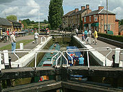
An inclined plane was opened at Foxton Locks
in 1900, as part of a plan to enable wide barges to use the Grand Union Canal
and thus bring more traffic onto the main line of the Grand Junction from the east Midlands. Widening of the locks at Watford
was also planned, but not carried through. Consideration was given to constructing other inclined planes as part of a plan to enlarge the canals to carry 80-ton barges, but no more were built.
With ever more traffic going by rail, the canal's only significant weapon was low tolls: while this slowed the decline in volumes, it did so only by large reductions in income, and consideration was given to amalgamations with other canals.
Concerns began to develop about the state of repair of the canal via Warwick to Birmingham, on which the Grand Junction was reliant for a through route. In 1925, discussions began with the three Warwick canals and the Regent's Canal, and in 1926 a merger was agreed. The Regent's Canal bought the Grand Junction Canal and the three Warwick canals, and from 1 January 1929 they became part of the (new) Grand Union Canal
.
Canal
Canals are man-made channels for water. There are two types of canal:#Waterways: navigable transportation canals used for carrying ships and boats shipping goods and conveying people, further subdivided into two kinds:...
in England from Braunston
Braunston
Braunston is a village and civil parish in the county of Northamptonshire, England. It has a population of 1,675 . Braunston is situated just off the A45 main road and lies between the towns of Rugby and Daventry....
in Northamptonshire
Northamptonshire
Northamptonshire is a landlocked county in the English East Midlands, with a population of 629,676 as at the 2001 census. It has boundaries with the ceremonial counties of Warwickshire to the west, Leicestershire and Rutland to the north, Cambridgeshire to the east, Bedfordshire to the south-east,...
to the River Thames
River Thames
The River Thames flows through southern England. It is the longest river entirely in England and the second longest in the United Kingdom. While it is best known because its lower reaches flow through central London, the river flows alongside several other towns and cities, including Oxford,...
at Brentford
Brentford
Brentford is a suburban town in west London, England, and part of the London Borough of Hounslow. It is located at the confluence of the River Thames and the River Brent, west-southwest of Charing Cross. Its former ceremonial county was Middlesex.-Toponymy:...
, with a number of branches. The mainline was built between 1793 and 1805, to improve the route from the Midlands
English Midlands
The Midlands, or the English Midlands, is the traditional name for the area comprising central England that broadly corresponds to the early medieval Kingdom of Mercia. It borders Southern England, Northern England, East Anglia and Wales. Its largest city is Birmingham, and it was an important...
to London, by-passing the upper reaches of the River Thames
River Thames
The River Thames flows through southern England. It is the longest river entirely in England and the second longest in the United Kingdom. While it is best known because its lower reaches flow through central London, the river flows alongside several other towns and cities, including Oxford,...
near Oxford
Oxford
The city of Oxford is the county town of Oxfordshire, England. The city, made prominent by its medieval university, has a population of just under 165,000, with 153,900 living within the district boundary. It lies about 50 miles north-west of London. The rivers Cherwell and Thames run through...
and by shortening the journey. The canal was bought by the Regent's Canal
Regent's Canal
Regent's Canal is a canal across an area just north of central London, England. It provides a link from the Paddington arm of the Grand Union Canal, just north-west of Paddington Basin in the west, to the Limehouse Basin and the River Thames in east London....
and from 1 January 1929 now forms the southern half of the Grand Union Main Line
Grand Union Canal
The Grand Union Canal in England is part of the British canal system. Its main line connects London and Birmingham, stretching for 137 miles with 166 locks...
from London to Birmingham
Birmingham
Birmingham is a city and metropolitan borough in the West Midlands of England. It is the most populous British city outside the capital London, with a population of 1,036,900 , and lies at the heart of the West Midlands conurbation, the second most populous urban area in the United Kingdom with a...
. The canal is now much used by leisure traffic.
The need for the Grand Junction
By 1790, an extensive network of canals was in place in the Midlands, or under construction. However, the only route to London was via the Oxford CanalOxford Canal
The Oxford Canal is a narrow canal in central England linking Oxford with Coventry via Banbury and Rugby. It connects with the River Thames at Oxford, to the Grand Union Canal at the villages of Braunston and Napton-on-the-Hill, and to the Coventry Canal at Hawkesbury Junction in Bedworth just...
to the River Thames at Oxford, and then down the river to the capital. The river, particularly the upper reaches, was in a poor condition for navigation compared with the modern canals. The river suffered from shallow sections and shortage of water leading to delays at locks, with conflicts with mill owners over water supplies common.
In 1791–1792, two surveys of a route from Brentford on the Thames to Braunston on the Oxford Canal were carried out, first by James Barnes and then by William Jessop
William Jessop
William Jessop was an English civil engineer, best known for his work on canals, harbours and early railways in the late 18th and early 19th centuries.-Early life:...
. There were other proposals for an alternative direct route to London, and two Bills were put to Parliament
Parliament of the United Kingdom
The Parliament of the United Kingdom of Great Britain and Northern Ireland is the supreme legislative body in the United Kingdom, British Crown dependencies and British overseas territories, located in London...
, but it was the Bill for the Grand Junction Canal which was passed on 30 April 1793.
Construction
The Act of ParliamentAct of Parliament
An Act of Parliament is a statute enacted as primary legislation by a national or sub-national parliament. In the Republic of Ireland the term Act of the Oireachtas is used, and in the United States the term Act of Congress is used.In Commonwealth countries, the term is used both in a narrow...
authorised the company to raise up to £600,000 to fund construction. The act authorised construction of the main line from where the eastern branch of the River Brent
River Brent
The Brent is a river within Greater London which is a tributary of the River Thames. It is 17.9 miles long, running north-east to south-west, and it joins the Thames on the Tideway at Brentford, Hounslow.- Hydronymy and etymology :...
enters the Thames at Syon House
Syon House
Syon House, with its 200-acre park, is situated in west London, England. It belongs to the Duke of Northumberland and is now his family's London residence...
near Brentford, to the Oxford Canal at Braunston. It also authorised branches to Daventry
Daventry
Daventry is a market town in Northamptonshire, England, with a population of 22,367 .-Geography:The town is also the administrative centre of the larger Daventry district, which has a population of 71,838. The town is 77 miles north-northwest of London, 13.9 miles west of Northampton and 10.2...
, the River Nene
River Nene
The River Nene is a river in the east of England that rises from three sources in the county of Northamptonshire. The tidal river forms the border between Cambridgeshire and Norfolk for about . It is the tenth longest river in the United Kingdom, and is navigable for from Northampton to The...
at Northampton
Northampton
Northampton is a large market town and local government district in the East Midlands region of England. Situated about north-west of London and around south-east of Birmingham, Northampton lies on the River Nene and is the county town of Northamptonshire. The demonym of Northampton is...
, to the turnpike
Turnpike trust
Turnpike trusts in the United Kingdom were bodies set up by individual Acts of Parliament, with powers to collect road tolls for maintaining the principal highways in Britain from the 17th but especially during the 18th and 19th centuries...
road (now the A5) at Old Stratford
Old Stratford
Old Stratford is a village in the south of the English county of Northamptonshire. The river Great Ouse forms the boundary with Buckinghamshire and Milton Keynes.-Location:...
, and to Watford
Watford
Watford is a town and borough in Hertfordshire, England, situated northwest of central London and within the bounds of the M25 motorway. The borough is separated from Greater London to the south by the urbanised parish of Watford Rural in the Three Rivers District.Watford was created as an urban...
: those to Daventry and Watford were not built.
William Jessop was appointed to take charge of construction which started almost immediately from the two ends. On 3 June 1793, James Barnes was appointed Engineer, at a rate of two guineas (£2.10) per day plus half a guinea (£0.52) expenses.
Blisworth Tunnel
Blisworth Tunnel is a canal tunnel on the Grand Union Canal in Northamptonshire, England between the villages of Stoke Bruerne at the southern end and Blisworth at the northern end.-Measurements:...
: quicksand was encountered, and errors made in alignment which meant that the tunnel had a pronounced wiggle. With the opening of Braunston Tunnel
Braunston Tunnel
Braunston Tunnel is situated on the Grand Union Canal just past Braunston, Northamptonshire, England.Braunston Tunnel is 2042 yards in length...
, the line was open from the Oxford Canal through to Weedon Bec
Weedon Bec
Weedon Bec , usually just called "Weedon", is a large village and parish in the district of Daventry, Northamptonshire, England. It lies close to the source of the River Nene.-Geography:...
in June 1796. However, Blisworth Tunnel continued to cause problems, collapsing in January 1796. The canal was opened from Braunston to Blisworth in 1797. The canal from the Thames reached Two Waters near Hemel Hempstead
Hemel Hempstead
Hemel Hempstead is a town in Hertfordshire in the East of England, to the north west of London and part of the Greater London Urban Area. The population at the 2001 Census was 81,143 ....
in 1798, Bulbourne at the north end of the Tring
Tring
Tring is a small market town and also a civil parish in the Chiltern Hills in Hertfordshire, England. Situated north-west of London and linked to London by the old Roman road of Akeman Street, by the modern A41, by the Grand Union Canal and by rail lines to Euston Station, Tring is now largely a...
summit in 1799, and Stoke Bruerne
Stoke Bruerne
Stoke Bruerne is a small village and civil parish in South Northamptonshire, England about north of Milton Keynes and south of Northampton.-History:...
at the south end of Blisworth Tunnel the following year.
Thus with the exception of Blisworth Tunnel, the main line was open throughout in 1800. To allow goods to cross the gap, a road was built in 1800 over the top of Blisworth hill, and later, upon the recommendation of committee member Joseph Wilkes
Joseph Wilkes
Joseph Wilkes was an 18th-century English industrialist and agricultural improver born in the village of Overseal in Derbyshire but more commonly associated with the village of Measham in Leicestershire....
, Benjamin Outram
Benjamin Outram
Benjamin Outram was an English civil engineer, surveyor and industrialist. He was a pioneer in the building of canals and tramways.-Personal life:...
was contracted to build a tramway over the hill.
James Barnes proposed that work begin again on the tunnel on a new line. Robert Whitworth and John Rennie were called in for advice, and supported this proposal. However, construction on the new line did not start until June 1802, and was not completed until March 1805.
Initially, nine locks were used in a temporary arrangement to lower and raise the canal for the crossing of the River Great Ouse
River Great Ouse
The Great Ouse is a river in the east of England. At long, it is the fourth-longest river in the United Kingdom. The river has been important for navigation, and for draining the low-lying region through which it flows. Its course has been modified several times, with the first recorded being in...
at Wolverton
Wolverton, Milton Keynes
Wolverton is a constituent town of Milton Keynes . It is at its northern edge, between Stony Stratford and Newport Pagnell...
at the river's water level. In 1799, William Jessop designed a three arch masonry aqueduct and embankment to cross the river and replace the locks. This collapsed in 1808, and a wooden trough was used as a temporary replacement. It was decided to build an iron aqueduct, with Benjamin Bevan as engineer. The foundation stone for the replacement aqueduct was laid on 9 September 1809, and it was opened on 22 January 1811.
The Grand Junction Canal had reduced the distance to London from the Midlands by 60 miles (100 kilometres)—via Oxford and the River Thames
River Thames
The River Thames flows through southern England. It is the longest river entirely in England and the second longest in the United Kingdom. While it is best known because its lower reaches flow through central London, the river flows alongside several other towns and cities, including Oxford,...
—and made the journey reliable. As a result it thrived: in 1810 it carried 343,560 tons
Long ton
Long ton is the name for the unit called the "ton" in the avoirdupois or Imperial system of measurements, as used in the United Kingdom and several other Commonwealth countries. It has been mostly replaced by the tonne, and in the United States by the short ton...
of goods through London, with roughly equal amounts into and out of the capital.
The branches
The Grand Junction's original act in 1793 authorised branches to Daventry, the River NeneRiver Nene
The River Nene is a river in the east of England that rises from three sources in the county of Northamptonshire. The tidal river forms the border between Cambridgeshire and Norfolk for about . It is the tenth longest river in the United Kingdom, and is navigable for from Northampton to The...
at Northampton, to the turnpike
Turnpike trust
Turnpike trusts in the United Kingdom were bodies set up by individual Acts of Parliament, with powers to collect road tolls for maintaining the principal highways in Britain from the 17th but especially during the 18th and 19th centuries...
road at Old Stratford (north-west of the modern Milton Keynes
Milton Keynes
Milton Keynes , sometimes abbreviated MK, is a large town in Buckinghamshire, in the south east of England, about north-west of London. It is the administrative centre of the Borough of Milton Keynes...
), and to Watford
Watford
Watford is a town and borough in Hertfordshire, England, situated northwest of central London and within the bounds of the M25 motorway. The borough is separated from Greater London to the south by the urbanised parish of Watford Rural in the Three Rivers District.Watford was created as an urban...
in Hertfordshire
Hertfordshire
Hertfordshire is a ceremonial and non-metropolitan county in the East region of England. The county town is Hertford.The county is one of the Home Counties and lies inland, bordered by Greater London , Buckinghamshire , Bedfordshire , Cambridgeshire and...
: those to Daventry and Watford were not built. The branch to Old Stratford was amended before it was built (see below). The branch to Northampton was delayed as the plans of the Leicester and Northampton Union Canal to reach Northampton and thus join with the Grand Junction came to nothing. The link to Northampton was made by a tramroad transferred from Blisworth Tunnel, with the 5-mile (8-kilometre) canal from Gayton being opened in 1815. The link to Leicester
Leicester
Leicester is a city and unitary authority in the East Midlands of England, and the county town of Leicestershire. The city lies on the River Soar and at the edge of the National Forest...
was eventually achieved by the opening of the Grand Union Canal
Grand Union Canal (old)
The Grand Union Canal was a canal in England from Foxton, Leicestershire on the Leicester and Northampton canal to Buckby on the Grand Junction Canal...
, which took a more direct route from Foxton
Foxton Locks
Foxton Locks are ten canal locks consisting of two "staircases" each of five locks, located on the Leicester line of the Grand Union Canal about 5 km west of the Leicestershire town of Market Harborough and are named after the nearby village of Foxton....
in Leicestershire
Leicestershire
Leicestershire is a landlocked county in the English Midlands. It takes its name from the heavily populated City of Leicester, traditionally its administrative centre, although the City of Leicester unitary authority is today administered separately from the rest of Leicestershire...
to the Grand Junction at Norton Junction.
The 1794 act authorised three further branches, to Aylesbury
Aylesbury
Aylesbury is the county town of Buckinghamshire in South East England. However the town also falls into a geographical region known as the South Midlands an area that ecompasses the north of the South East, and the southern extremities of the East Midlands...
, Buckingham
Buckingham
Buckingham is a town situated in north Buckinghamshire, England, close to the borders of Northamptonshire and Oxfordshire. The town has a population of 11,572 ,...
, and Wendover
Wendover
Wendover is a market town that sits at the foot of the Chiltern Hills in Buckinghamshire, England. It is also a civil parish within Aylesbury Vale district...
. The 6.5-mile (10.5-kilometre) navigable feeder from Wendover to the summit level at Tring was opened in 1799, while the 10.5-mile (17 kilometre) Buckingham branch
Buckingham Arm
The Buckingham Arm is a canal that once ran from Cosgrove, Northamptonshire to Buckingham . It was built as an arm of the Grand Junction Canal, in two separate phases, opening in 1800 and 1801. It was disused from 1932, but was not finally abandoned until 1964...
, an extension of the original proposal for a link to the main road at Old Stratford, was opened in 1801: both eventually fell into disuse, though the Wendover Arm is undergoing active restoration, and part of it is again navigable. The Aylesbury arm was envisaged to become a through route to the Thames and thus the Wilts and Berks Canal
Wilts and Berks Canal
The Wilts & Berks Canal is a canal in the historic counties of Wiltshire and Berkshire, England, linking the Kennet and Avon Canal at Semington, near Melksham, to the River Thames at Abingdon. The North Wilts Canal merged with it to become a branch to the Thames and Severn Canal at Latton near...
and Kennet and Avon Canal
Kennet and Avon Canal
The Kennet and Avon Canal is a waterway in southern England with an overall length of , made up of two lengths of navigable river linked by a canal. The name is commonly used to refer to the entire length of the navigation rather than solely to the central canal section...
, but the 6-mile (10-kilometre) branch into the town, opened in 1815, was never extended.
The act of April 1795 authorised a 13.5-mile (22-kilometre) branch to Paddington from Bull's Bridge near Hayes
Hayes, Hillingdon
Hayes is a town in the London Borough of Hillingdon, West London. It is a suburban development situated west of Charing Cross. Hayes was developed in the late 19th and 20th centuries as an industrial locality to which residential districts were later added in order to house factory workers...
: this was completed in 1801, and with its large basin at Paddington and many wharfs along its length it became an important trade route, even more so with the subsequent opening of the Regent's Canal
Regent's Canal
Regent's Canal is a canal across an area just north of central London, England. It provides a link from the Paddington arm of the Grand Union Canal, just north-west of Paddington Basin in the west, to the Limehouse Basin and the River Thames in east London....
. This branch also acted as a source of water from the River Brent.
The act of June 1795 authorised a branch to St Albans: this was not built.
The last branch to be authorised and built was the 5-mile (8-kilometre) route to Slough
Slough
Slough is a borough and unitary authority within the ceremonial county of Royal Berkshire, England. The town straddles the A4 Bath Road and the Great Western Main Line, west of central London...
, opened in 1882.
Acts of Parliament
- 33 Geo. III. C. 80, received Royal Assent on 30 April 1793
- An Act for making and maintaining a navigable Canal from the Oxford Canal Navigation at Braunston, in the county of Northampton, to join the River Thames at or near Brentford, in the county of Middlesex; and also certain collateral Cuts from the said intended Canal.
- 34 Geo. III. C. 24, received Royal Assent on 28 March 1794
- An Act for making certain navigable Cuts from the towns of Buckingham, Aylesbury, and Wendover, in the county of Buckingham, to communicate with the Grand Junction Navigation authorized to be made by an Act of the last Session of Parliament, and for amending the said Act.
- 35 Geo. III. C. 8, received Royal Assent on 5 March 1795
- An Act for authorizing the Company of the Grand Junction Canal to vary the Course of a certain Part of the said Canal, in the county of Hertford, so as to render the Navigation thereof more safe and convenient, and for making some other Amendments and Alterations in an Act made in the Thirty-third Year of the Reign of his present Majesty, for making the said Canal.
- 35 Geo. III. C. 43, received Royal Assent on 28 April 1795
- An Act for making a navigable Cut from the Grand Junction Canal, in the precinct of Norwood, in the county of Middlesex, to Paddington, in the said county
- 35 Geo. III. C. 85, received Royal Assent on 2 June 1795
- An Act for making and extending a navigable Cut from the town of Watford, in the county of Hertford, to the town of St. Alban, in the same county,
- 36 Geo. III. C. 25, received Royal Assent on 24 December 1795
- An Act to enable the Company of Proprietors of the Grand Junction Canal to finish and complete the same, and the several Cuts and other Works authorized to be made and done by them, by virtue of several Acts of Parliament
- 38 Geo. III. C. 33, received Royal Assent on 26 May 1798
- An Act for confirming and carrying into Execution certain Articles of Agreement made and entered into between Beilby, Lord Bishop of London, Thomas Wood, Esq. Sir John Frederick, Bart. and Arthur Stanhope, Esq. Sir John Morshead, Bart. and Dame Elizabeth his wife, and Robert Thistlethwaite, Esq. and Selina his wife, and the Company of Proprietors of the Grand Junction Canal; and for other Purposes therein-mentioned
- 41 Geo. III. C. 71, received Royal Assent on 20 June 1801
- An Act for enabling the Company of Proprietors of the Grand Junction Canal more effectually to provide for the Discharge of their Debts, and to complete the whole of the Works to be executed by them, in pursuance of the several Acts of the Thirty-third, Thirty-fourth, Thirty-fifth, Thirty-sixth, and Thirty-eighth Years of the Reign of his present Majesty; and for altering and enlarging the Powers and Provisions of the said Acts
- 43 Geo. III. C. 8, received Royal Assent on 24 March 1803
- An Act for empowering the Company of Proprietors of the Grand Junction Canal, to raise a further Sum of Money to enable them to complete the Works authorized to be executed, in pursuance of the several Acts passed in the Thirty-third, Thirty-fourth, Thirty-fifth, Thirty-sixth, Thirty-eighth, and Forty-first Years of the Reign of his present Majesty; and for amending, altering, and enlarging the Powers and Provisions of the said Acts
- 45 Geo. III. C. 68, received Royal Assent on 27 June 1805
- An Act for altering, amending, and enlarging the Powers of certain Acts for making and maintaining the Grand Junction Canal
- 52 Geo. III. C. 140, received Royal Assent on 9 June 1812
- An Act to explain, amend, and enlarge the Powers of certain Acts passed for making and maintaining the Grand Junction Canal
- 58 Geo. III. C. 16, received Royal Assent on 17 March 1818
- An Act to enable the Grand Junction Canal Company to vary the Line of Part of their Canal in the county of Hertford, and for altering and enlarging the Powers of several Acts relating to the said Canal.
- 59 Geo. III. C. 111, received Royal Assent on 22 June 1819
- An Act to vary and alter certain Acts of his present Majesty, relating to the Grand Junction Canal, the Grand Junction Water Works, and the Regent's Canal, in order to effect an Exchange of Water, for the better Supply of the Regent's Canal Navigation and Grand Junction Water Works.
This list is incomplete. Among those missing are the act authorising construction of the Slough Arm, and acts in 1928 authorising the formation of the Grand Union Canal
Grand Union Canal
The Grand Union Canal in England is part of the British canal system. Its main line connects London and Birmingham, stretching for 137 miles with 166 locks...
.
Further development
A clause under their acts allowed the Grand Junction Canal to supply drinking water. Accordingly the Grand Junction Waterworks CompanyGrand Junction Waterworks Company
The Grand Junction Waterworks Company was a utility company supplying water to parts of west London in England. The company was formed as an off-shoot of the Grand Junction Canal Company in 1811 and became part of the publicly-owned Metropolitan Water Board in 1903.-Origins:The company was created...
was established in 1811, initially taking water from the River Colne
River Colne, Hertfordshire
The Colne is a river in England which is a tributary of the River Thames. It flows mainly through Hertfordshire and forms the boundary between the South Bucks district of Buckinghamshire and the London Borough of Hillingdon...
, the River Brent
River Brent
The Brent is a river within Greater London which is a tributary of the River Thames. It is 17.9 miles long, running north-east to south-west, and it joins the Thames on the Tideway at Brentford, Hounslow.- Hydronymy and etymology :...
and a reservoir in North West Middlesex. These waters proved unsatisfactory and the Company transferred its inlets to the River Thames.
The importance of trade between London and the Midlands meant that railway competition was an early threat to this canal compared with others in the country. John Rennie undertook a survey in 1824 for a London to Birmingham railway.
There were also ambitious proposals for new canals. In 1827 there was a proposals for a London and Birmingham Junction Canal from the Stratford-upon-Avon Canal
Stratford-upon-Avon Canal
The Stratford-upon-Avon Canal is a canal in the south Midlands of England.The canal, which was built between 1793 and 1816, runs for in total, and consists of two sections. The dividing line is at Kingswood Junction, which gives access to the Grand Union Canal...
to Braunston. In 1832, William Cubitt
William Cubitt
Sir William Cubitt was an eminent English civil engineer and millwright. Born in Norfolk, England, he was employed in many of the great engineering undertakings of his time. He invented a type of windmill sail and the prison treadwheel, and was employed as chief engineer, at Ransomes of Ipswich,...
proposed a Central Union Canal from the Worcester and Birmingham Canal
Worcester and Birmingham Canal
The Worcester and Birmingham Canal is a canal linking Birmingham and Worcester in England. It starts in Worcester, as an 'offshoot' of the River Severn and ends in Gas Street Basin in Birmingham. It is long....
near Worcester Bar via Solihull
Solihull
Solihull is a town in the West Midlands of England with a population of 94,753. It is a part of the West Midlands conurbation and is located 9 miles southeast of Birmingham city centre...
to the Oxford at Ansty, while in 1833 there were proposals for a London and Birmingham Canal, from Stratford
Stratford, London
Stratford is a place in the London Borough of Newham, England. It is located east northeast of Charing Cross and is one of the major centres identified in the London Plan. It was historically an agrarian settlement in the ancient parish of West Ham, which transformed into an industrial suburb...
direct to the Regent's Canal, which would bypass the Grand Junction Canal entirely. Together with the railway threats, the Grand Junction was spurred into making improvements.
The London and Birmingham Railway
London and Birmingham Railway
The London and Birmingham Railway was an early railway company in the United Kingdom from 1833 to 1846, when it became part of the London and North Western Railway ....
was completed in 1838, and, with the exception of the Oxford Canal, the canals on the route from London to Birmingham co-operated to reduce tolls to compete with the railway. As a result, traffic carried increased, but income was significantly reduced.
To cope with the traffic volumes, the locks at Stoke Bruerne
Stoke Bruerne
Stoke Bruerne is a small village and civil parish in South Northamptonshire, England about north of Milton Keynes and south of Northampton.-History:...
were duplicated in 1835, and new larger reservoirs built at Tring to ease a serious water shortage. In 1848 the Grand Junction entered the carrying trade, pitting its boats directly against the railway competition. From 1864 steam narrow boats were acquired, working with a butty, and these penetrated as far as the Erewash Canal
Erewash Canal
The Erewash Canal is a broad canal in Derbyshire, England. It runs just under and has 14 locks. The first lock at Langley Bridge is actually part of the Cromford Canal.-Origins:...
. Carrying was given up in 1876 because it did not pay.
By 1871 the tunnels at Braunston and Blisworth were becoming bottlenecks and steam tugs were provided to tow strings of waiting boats through.
Under the encouragement of major carriers Fellows Morton and Clayton
Fellows Morton and Clayton
Fellows Morton & Clayton Ltd was, for much of the early 20th century, the largest and best-known canal transportation company in England. The company was in existence from 1889 to 1947.-Origins:...
, the Grand Junction bought the Grand Union Canal
Grand Union Canal (old)
The Grand Union Canal was a canal in England from Foxton, Leicestershire on the Leicester and Northampton canal to Buckby on the Grand Junction Canal...
and Leicester and Northamptonshire Union Canal in 1894 and worked with other navigations to encourage more through traffic to London: the Grand Junction was concerned that through traffic was being deterred by the poor condition and high tolls of the railway-owned Cromford Canal
Cromford Canal
The Cromford Canal ran 14.5 miles from Cromford to the Erewash Canal in Derbyshire, England with a branch to Pinxton. Built by William Jessop with the assistance of Benjamin Outram, its alignment included four tunnels and 14 locks....
and Nottingham Canal
Nottingham Canal
The Nottingham Canal was a long canal between Langley Mill in Derbyshire and Nottingham, England. It opened in 1796, and most of it was closed in 1937. The southern section is now part of the River Trent Navigation, and the northern section is a nature reserve.-Origins:The idea for the canal first...
.
An inclined plane was opened at Foxton Locks
Foxton Locks
Foxton Locks are ten canal locks consisting of two "staircases" each of five locks, located on the Leicester line of the Grand Union Canal about 5 km west of the Leicestershire town of Market Harborough and are named after the nearby village of Foxton....
in 1900, as part of a plan to enable wide barges to use the Grand Union Canal
Grand Union Canal (old)
The Grand Union Canal was a canal in England from Foxton, Leicestershire on the Leicester and Northampton canal to Buckby on the Grand Junction Canal...
and thus bring more traffic onto the main line of the Grand Junction from the east Midlands. Widening of the locks at Watford
Watford Locks
Watford Locks is a group of seven locks on the Leicester Line of the Grand Union Canal, in Northamptonshire, England, famous for the Watford Gap service area....
was also planned, but not carried through. Consideration was given to constructing other inclined planes as part of a plan to enlarge the canals to carry 80-ton barges, but no more were built.
With ever more traffic going by rail, the canal's only significant weapon was low tolls: while this slowed the decline in volumes, it did so only by large reductions in income, and consideration was given to amalgamations with other canals.
Concerns began to develop about the state of repair of the canal via Warwick to Birmingham, on which the Grand Junction was reliant for a through route. In 1925, discussions began with the three Warwick canals and the Regent's Canal, and in 1926 a merger was agreed. The Regent's Canal bought the Grand Junction Canal and the three Warwick canals, and from 1 January 1929 they became part of the (new) Grand Union Canal
Grand Union Canal
The Grand Union Canal in England is part of the British canal system. Its main line connects London and Birmingham, stretching for 137 miles with 166 locks...
.
Further reading
- Hadfield, C., and Skempton, A.W., (1979) "William Jessop, Engineer" David and Charles Publishers.
- Faulkner, Alan H., (1972) "The Grand Junction Canal" David and Charles Publishers.
- Hassell, John (1819) "Tour of the Grand Junction, illustrated in a series of engravings, with an historical and topographical description of those parts of the counties of Middlesex, Hertfordshire, Buckinghamshire, Bedfordshire, and Northamptonshire, through which the canal passes" Published by J. Hassell Google Books
- The Mechanics' Magazine, Museum, Register, Journal and Gazette. (1834) Letter: "Improvement in the Locks of the Grand Junction Canal Company" Google Books
See also
- Canals of Great Britain
- History of the British canal systemHistory of the British canal systemThe British canal system of water transport played a vital role in the United Kingdom's Industrial Revolution at a time when roads were only just emerging from the medieval mud and long trains of pack horses were the only means of "mass" transit by road of raw materials and finished products The...