

Flag Fen
Encyclopedia
Peterborough
Peterborough is a cathedral city and unitary authority area in the East of England, with an estimated population of in June 2007. For ceremonial purposes it is in the county of Cambridgeshire. Situated north of London, the city stands on the River Nene which flows into the North Sea...
, England is a Bronze Age
Bronze Age
The Bronze Age is a period characterized by the use of copper and its alloy bronze as the chief hard materials in the manufacture of some implements and weapons. Chronologically, it stands between the Stone Age and Iron Age...
site, probably religious. It comprises over 60,000 timbers arranged in five very long rows (around 1 km) connecting Whittlesey
Whittlesey
Whittlesey, historically known as Whittlesea as the name of the railway station is still spelt, or Witesie, is an ancient Fenland market town around six miles east of Peterborough in the county of Cambridgeshire in England...
Island with Peterborough across the wet fenland. Part way across the structure, a small island was formed which is where it is presumed that the religious ceremonies occurred. Dendrochronological dating provides a date of 1365–967 BC. There was great environmental change during this period. The land began to get wetter as there were more rainy seasons floods were common. Due to this, people were losing the land on which they farmed, causing great alarm for the nearby populations.
In the 10th century BC the ground level was much lower than today, increasing around 1 mm (0.039 inches) per year as autumnal debris is added to the surface of the fens. This caused the structure to be covered up and preserved. The anaerobic
Hypoxia (environmental)
Hypoxia, or oxygen depletion, is a phenomenon that occurs in aquatic environments as dissolved oxygen becomes reduced in concentration to a point where it becomes detrimental to aquatic organisms living in the system...
conditions found in the waterlogged soil prevented the timbers and other wooden objects from rotting away. The site was first discovered in 1982 when a team led by Francis Pryor
Francis Pryor
thumb|180px|Francis Pryor discusses the excavation during the filming of a 2007 dig for [[Time Team]] with series editor Michael Douglas ....
carried out a survey
Archaeological field survey
Archaeological field survey is the method by which archaeologists search for archaeological sites and collect information about the location, distribution and organization of past human cultures across a large area...
of dykes in the area funded by English Heritage
English Heritage
English Heritage . is an executive non-departmental public body of the British Government sponsored by the Department for Culture, Media and Sport...
.
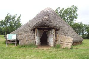
Due to extensive drainage of the surrounding area, many of the timbers are drying out and are threatened with destruction. Archaeologists are studying it and there is a well-organised visitor centre there with museum and exhibitions. In the preservation hall one section of the timbers is preserved in-situ and prevented from drying out by misting with water. Also at the site are reconstructions of two Bronze Age roundhouses
Roundhouse (dwelling)
The roundhouse is a type of house with a circular plan, originally built in western Europe before the Roman occupation using walls made either of stone or of wooden posts joined by wattle-and-daub panels and a conical thatched roof. Roundhouses ranged in size from less than 5m in diameter to over 15m...
and one from the Iron Age
Iron Age
The Iron Age is the archaeological period generally occurring after the Bronze Age, marked by the prevalent use of iron. The early period of the age is characterized by the widespread use of iron or steel. The adoption of such material coincided with other changes in society, including differing...
. There is also an exposed section of the Roman road
Roman road
The Roman roads were a vital part of the development of the Roman state, from about 500 BC through the expansion during the Roman Republic and the Roman Empire. Roman roads enabled the Romans to move armies and trade goods and to communicate. The Roman road system spanned more than 400,000 km...
known as the Fen Causeway
Fen Causeway
Fen Causeway or the Fen Road is the modern name for a Roman road of England that runs between Denver, Norfolk in the east and Peterborough in the west. Its path covers , passing March and Eldernell before joining the major Roman north-south route Ermine Street west of modern-day Peterborough...
which crosses the site and a reconstruction of a Prehistoric droveway.
One section of the poles is being preserved by replacing the cellulose in the wood with water carried wax impregnating of the wood over the years. This technique is also being used to preserve Seahenge
Seahenge
Seahenge, which is also known as Holme I, was a prehistoric monument located in the village of Holme-next-the-Sea, near Old Hunstanton in the English county of Norfolk...
. Another preservation technique used for timbers found at the site is freeze drying
Freeze drying
Freeze-drying is a dehydration process typically used to preserve a perishable material or make the material more convenient for transport...
.
In the surrounding water of Flag Fen votive offerings have been found, e.g., daggers broken in half placed on top of each other. This supports the theory that Flag Fen was a site involved in religious rites, as great wealth was being thrown into the water. One theory, is that these were being given as votive offerings to the Gods, to ask them to stop the environmental changes which were occurring around the time. Amongst the daggers and jewellery found, there were a number of small, white beach pebbles. These were not natural to the local area which suggests that people travelled from afar to give offerings to the Gods. Other artefacts that were found comprised animal bones. Of these, horse mandibles were found. Horses were very valuable to the prehistoric people, as they provided not only a means of transport, but also man power. They could be used to carry timbers, for example, over long distances.
Some of the timbers themselves were not natural to the local environment, as few were made of oak. This means that the people who constructed this timber causeway wanted to use materials that perhaps had religious significance to their lives, and felt that it was worth the effort to transport the timbers from far lying sources to the site itself. This isn't rare in the prehistoric world, as the bluestones from Stonehenge
Stonehenge
Stonehenge is a prehistoric monument located in the English county of Wiltshire, about west of Amesbury and north of Salisbury. One of the most famous sites in the world, Stonehenge is composed of a circular setting of large standing stones set within earthworks...
were brought to the site in Salisbury from the Preseli Mountains in Wales.
On the island known as Northey Island, many round barrows, contemporary with Flag Fen, were found. These seemed to be constructed over the dwellings of 'chiefs'. Mike Parker Pearson
Mike Parker Pearson
Michael "Mike" Parker Pearson is a professor in the Department of Archaeology at the University of Sheffield in England. His books include The Archaeology of Death and Burial, Bronze Age Britain, Architecture and Order and In Search of the Red Slave...
refers to this as the "Land of the Dead", although there is evidence of farming, including sheep remains, contemporary with the site. Phosphate analysis reveals high concentrations of cremations in the barrows, in the form of satellite and secondary burials in the round barrows. This suggests that the primary burials may have been of chiefs, or socially powerful/respected people, and that some people may have paid to be buried close to the person they respected or followed.
External links
- Flag Fen Bronze Age Centre and Archaeology Park
- Fenland Archaeological Trust registered charity no. 295116
- Peterborough Museum