

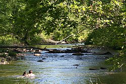
Rivanna River
Encyclopedia
The Rivanna River is a 42.1 miles (67.8 km) tributary
of the James River
in central Virginia
in the United States
. The Rivanna's tributaries originate in the Blue Ridge Mountains
; via the James River, it is part of the watershed
of Chesapeake Bay
.
According to the Geographic Names Information System
, the Rivanna has also been known as "Mountain Falls Creek" and "River Anna".
about 4 miles (6.4 km) northeast of Charlottesville
by the confluence of two tributaries:
Below this confluence, the Rivanna flows southeast through Albemarle County, skirting the eastern edge of Charlottesville and breaching the Southwest Mountains
near Monticello
. The Rivanna continues southeast through Fluvanna County
, passing the communities of Lake Monticello
and Palmyra
; it enters the James River at the town of Columbia
.
ans. The locations of several sites from the period are known, and some have been explored by archaeologists. One in particular, a mound postulated to be the site of ritual burial
and of spiritual significance to the tribe, is located near the confluence
of the two forks of the river and was documented by Thomas Jefferson
in his 1781 work Notes on the State of Virginia
. Several major population centers of the tribe were located along the Rivanna, including Monasukapanough, near the headwaters of the river, and Rassawek, the principal town of the tribe, located at the confluence of the Rivanna and James rivers.
In the late eighteenth century the river was made navigable
, partially by the efforts of the Jeffersons who owned much of the lands along its upper course, including Shadwell
where Peter Jefferson
had built a small mill complex on the river, overlooked by a lofty hill now known as Monticello
. Improvements included in the first generation (through approximately 1830) were sluice
cuts, small dam
s, and batteaux
locks. Second generation (approx. 1840-1870) improvements had long stretches of canal
, serviced by large locks
, many of which are still visible along the river today. Shortly after the completion of the initial Rivanna navigational works, Virginia
requested that the river be opened to public usage. It is said Jefferson at first refused, but the commonwealth
would not be denied, and the Rivanna became an integral part of the central Virginian transportation network.
 The route served a large community of farm
steads and plantation
s throughout Albemarle
and Fluvanna
counties. It also bore ever-growing numbers of industrial
facilities, like those at Union Mills
. It was the construction of these larger mills which prompted the great "second generation" improvements to navigation which were coordinated by the Rivanna Navigation Company. Union Mills alone featured a 2.5 miles (4 km) canal and towpath
, one upper and two massive lower locks, all directly upon the river.
Where the Rivanna meets the James River at Columbia
so too did the 4.5 miles (7.2 km) Rivanna Connexion canal merge with the James River and Kanawha Canal
, itself an altogether impressive work intended to connect Richmond
with the Ohio River
and the West. The series of locks which connected the two works lie just outside of the town, and are mostly buried by sediment today.
In the batteaux era Milton
was the head of navigation along the river, but by the mid-nineteenth century horse-drawn canal boats were traveling all the way upstream to Charlottesville
, where the head of navigation was located at the very point where the Fredericksburg Road (now VA 20
) and Three Chopt Road (U.S. Route 250
), the primary road to Richmond, meet and enter the city over the Free Bridge, establishing the city as a major commercial hub.
During the late twentieth century the river saw the establishment of the Rivanna Trail, a greenbelt
trail that encircles the city of Charlottesville. As its name suggests the trail was originally envisioned as a river-front promenade
, after the San Antonio River Walk
, but the plan was soon enlarged under the guidance of the Rivanna Trails Foundation. It now takes hikers
all the way around Charlottesville, passing through many of the city's parks and the wooded lands surrounding it, totaling over 20 miles (32.2 km) in length.
, noting its many endemic and rare species including the endangered James River spinymussel
, identified the Rivanna basin as “one of the finest remaining freshwater river and stream systems in the Piedmont
.” In 2002 a community-based monitoring program called StreamWatch
was founded and began intensive data collection at permanent stream monitoring sites throughout the watershed. In 2006 The Nature Conservancy raised funds and approached local governments to successfully facilitate the establishment of the Rivanna River Basin Commission, a multi-jurisdictional body composed of local elected officials, Soil and Water Conservation District representatives, and citizens.
In 2008 the Rivanna River Basin Commission Technical Advisory Committee identified altered hydrology and sediment pollution as principal threats to the health of the system. (In general, altered hydrology refers changes in flow regime due to impervious land cover, withdrawals, and dams. The Technical Committee’s findings regarding the Rivanna were limited to land-cover mediated hydrological alteration).
The Rivanna is a source of drinking water to the Charlottesville area and Lake Monticello. Water supply management and planning have been somewhat controversial. In 2006 a plan to expand water supply by piping water from South Fork Rivanna Reservoir to an enlarged Ragged Mountain Reservoir gained wide endorsement from environmental organizations, the water authority, and permitting agencies. Subsequently, however, some citizens have criticized the plan on the basis of cost, and have encouraged further research about dredging the South Fork Rivanna Reservoir.
In most respects, Rivanna management and conservation efforts have been marked by significant cooperation among diverse stakeholders. The Rivanna River Basin Commission and the community monitoring program (StreamWatch) feature substantial participation by citizens, the conservation community (e.g. Rivanna Conservation Society), local governments (Albemarle County, Fluvanna County, Greene County, and the City of Charlottesville), resource management agencies (Virginia Department of Environmental Quality, Virginia Department of Game and Inland Fisheries, Thomas Jefferson Soil and Water Conservation District) and quasi-governmental organizations (Rivanna Water and Sewer Authority, Thomas Jefferson Planning District Commission).
Tributary
A tributary or affluent is a stream or river that flows into a main stem river or a lake. A tributary does not flow directly into a sea or ocean...
of the James River
James River
The James River may refer to:Rivers in the United States and their namesakes* James River * James River , North Dakota, South Dakota* James River * James River * James River...
in central Virginia
Virginia
The Commonwealth of Virginia , is a U.S. state on the Atlantic Coast of the Southern United States. Virginia is nicknamed the "Old Dominion" and sometimes the "Mother of Presidents" after the eight U.S. presidents born there...
in the United States
United States
The United States of America is a federal constitutional republic comprising fifty states and a federal district...
. The Rivanna's tributaries originate in the Blue Ridge Mountains
Blue Ridge Mountains
The Blue Ridge Mountains are a physiographic province of the larger Appalachian Mountains range. This province consists of northern and southern physiographic regions, which divide near the Roanoke River gap. The mountain range is located in the eastern United States, starting at its southern-most...
; via the James River, it is part of the watershed
Drainage basin
A drainage basin is an extent or an area of land where surface water from rain and melting snow or ice converges to a single point, usually the exit of the basin, where the waters join another waterbody, such as a river, lake, reservoir, estuary, wetland, sea, or ocean...
of Chesapeake Bay
Chesapeake Bay
The Chesapeake Bay is the largest estuary in the United States. It lies off the Atlantic Ocean, surrounded by Maryland and Virginia. The Chesapeake Bay's drainage basin covers in the District of Columbia and parts of six states: New York, Pennsylvania, Delaware, Maryland, Virginia, and West...
.
According to the Geographic Names Information System
Geographic Names Information System
The Geographic Names Information System is a database that contains name and locative information about more than two million physical and cultural features located throughout the United States of America and its territories. It is a type of gazetteer...
, the Rivanna has also been known as "Mountain Falls Creek" and "River Anna".
Course
The Rivanna River is formed in Albemarle CountyAlbemarle County, Virginia
As of the census of 2000, there were 79,236 people, 31,876 households, and 21,070 families residing in the county. The population density was 110 people per square mile . There were 33,720 housing units at an average density of 47 per square mile...
about 4 miles (6.4 km) northeast of Charlottesville
Charlottesville, Virginia
Charlottesville is an independent city geographically surrounded by but separate from Albemarle County in the Commonwealth of Virginia, United States, and named after Charlotte of Mecklenburg-Strelitz, the queen consort of King George III of the United Kingdom.The official population estimate for...
by the confluence of two tributaries:
- The North Fork Rivanna River is formed in southwestern Greene CountyGreene County, VirginiaAs of the census of 2000, there are 15,244 people, 5,574 households, and 4,291 families residing in the county. The population density is 97 people per square mile . There are 5,986 housing units at an average density of 38 per square mile...
by the confluence of the Lynch RiverLynch RiverThe Lynch River is a tributary of the North Fork Rivanna River in the U.S. state of Virginia. It is part of the James River watershed. It rises at the unincorporated community of Mission Home near the boundary of Shenandoah National Park and flows southeast past Shady Grove and Nortonsville to...
and the Roach River, and flows 18 miles (29 km) southeast by south into Albemarle County. - The South Fork Rivanna River is formed in Albemarle County by the confluence of the Moormans RiverMoormans RiverThe Moormans River is a tributary of the South Fork of the Rivanna River in central Virginia in the United States. Via the Rivanna and James rivers, it is part of the watershed of Chesapeake Bay....
and the Mechums RiverMechums RiverThe Mechums River is a tributary of the South Fork of the Rivanna River in central Virginia in the United States. Via the Rivanna and James rivers, it is part of the watershed of Chesapeake Bay.-Course:...
, and flows 12.9 miles (20.8 km) generally eastwardly.
Below this confluence, the Rivanna flows southeast through Albemarle County, skirting the eastern edge of Charlottesville and breaching the Southwest Mountains
Southwest Mountains
The Southwest Mountains of Virginia are a mountain range centered around Charlottesville, parallel to and geologically associated with the Blue Ridge Mountains, which lie about 30 miles to the west...
near Monticello
Monticello
Monticello is a National Historic Landmark just outside Charlottesville, Virginia, United States. It was the estate of Thomas Jefferson, the principal author of the United States Declaration of Independence, third President of the United States, and founder of the University of Virginia; it is...
. The Rivanna continues southeast through Fluvanna County
Fluvanna County, Virginia
As of 2002, Fluvanna County's population was 20,047. There are 7,387 households, and 5,702 families residing in the county. The population density was 70 people per square mile . There were 8,018 housing units at an average density of 28 per square mile...
, passing the communities of Lake Monticello
Lake Monticello, Virginia
Lake Monticello is a census-designated place in Fluvanna County, Virginia, United States. The population was 6,852 at the 2000 census. The community is centered on a lake of the same name, which is formed by a dam on a short tributary of the nearby Rivanna River...
and Palmyra
Palmyra, Virginia
Palmyra is a census-designated place in and the county seat of Fluvanna County, Virginia, United States. The population as of the 2010 Census was 104. Palmyra lies on the eastern bank of the Rivanna River along U.S. Route 15...
; it enters the James River at the town of Columbia
Columbia, Virginia
Columbia is a town in Fluvanna County, Virginia, United States, at the confluence of the James and Rivanna Rivers. The population was 49 at the 2000 census, making it Virginia's smallest incorporated town...
.
History
Monacan Indians were the inhabitants of the Rivanna valley at the time of first contact by EuropeEurope
Europe is, by convention, one of the world's seven continents. Comprising the westernmost peninsula of Eurasia, Europe is generally 'divided' from Asia to its east by the watershed divides of the Ural and Caucasus Mountains, the Ural River, the Caspian and Black Seas, and the waterways connecting...
ans. The locations of several sites from the period are known, and some have been explored by archaeologists. One in particular, a mound postulated to be the site of ritual burial
Burial
Burial is the act of placing a person or object into the ground. This is accomplished by excavating a pit or trench, placing an object in it, and covering it over.-History:...
and of spiritual significance to the tribe, is located near the confluence
Confluence
Confluence, in geography, describes the meeting of two or more bodies of water.Confluence may also refer to:* Confluence , a property of term rewriting systems...
of the two forks of the river and was documented by Thomas Jefferson
Thomas Jefferson
Thomas Jefferson was the principal author of the United States Declaration of Independence and the Statute of Virginia for Religious Freedom , the third President of the United States and founder of the University of Virginia...
in his 1781 work Notes on the State of Virginia
Notes on the State of Virginia
Notes on the State of Virginia was a book written by Thomas Jefferson. He completed the first edition in 1781, and updated and enlarged the book in 1782 and 1783...
. Several major population centers of the tribe were located along the Rivanna, including Monasukapanough, near the headwaters of the river, and Rassawek, the principal town of the tribe, located at the confluence of the Rivanna and James rivers.
In the late eighteenth century the river was made navigable
Navigability
A body of water, such as a river, canal or lake, is navigable if it is deep, wide and slow enough for a vessel to pass. Preferably there are few obstructions such as rocks or trees to avoid. Bridges must have sufficient clearance. High water speed may make a channel unnavigable. Waters may be...
, partially by the efforts of the Jeffersons who owned much of the lands along its upper course, including Shadwell
Shadwell (Virginia)
Shadwell, a location by the Rivanna river in Albemarle County, Virginia near Charlottesville, was the birthplace of Thomas Jefferson. It was so named by Peter Jefferson after Shadwell parish in London where his wife Jane Randolph had been christened...
where Peter Jefferson
Peter Jefferson
Peter Jefferson was the father of American President Thomas Jefferson . A surveyor and cartographer, his Fry-Jefferson Map of 1751 accurately depicted the Allegheny Mountains for the first time and showed the route of "The Great Road from the Yadkin River thro Virginia to Philadelphia distant 455...
had built a small mill complex on the river, overlooked by a lofty hill now known as Monticello
Monticello
Monticello is a National Historic Landmark just outside Charlottesville, Virginia, United States. It was the estate of Thomas Jefferson, the principal author of the United States Declaration of Independence, third President of the United States, and founder of the University of Virginia; it is...
. Improvements included in the first generation (through approximately 1830) were sluice
Sluice
A sluice is a water channel that is controlled at its head by a gate . For example, a millrace is a sluice that channels water toward a water mill...
cuts, small dam
Dam
A dam is a barrier that impounds water or underground streams. Dams generally serve the primary purpose of retaining water, while other structures such as floodgates or levees are used to manage or prevent water flow into specific land regions. Hydropower and pumped-storage hydroelectricity are...
s, and batteaux
James River Bateau
The James River Bateau was a shallow draft river craft used during the period from 1775 to 1840 to transport tobacco and other cargo on the James river and its tributaries in the state of Virginia. It was flat bottomed and pointed at both ends. The length of the bateau varied greatly, 58 feet ...
locks. Second generation (approx. 1840-1870) improvements had long stretches of canal
Canal
Canals are man-made channels for water. There are two types of canal:#Waterways: navigable transportation canals used for carrying ships and boats shipping goods and conveying people, further subdivided into two kinds:...
, serviced by large locks
Lock (water transport)
A lock is a device for raising and lowering boats between stretches of water of different levels on river and canal waterways. The distinguishing feature of a lock is a fixed chamber in which the water level can be varied; whereas in a caisson lock, a boat lift, or on a canal inclined plane, it is...
, many of which are still visible along the river today. Shortly after the completion of the initial Rivanna navigational works, Virginia
Virginia
The Commonwealth of Virginia , is a U.S. state on the Atlantic Coast of the Southern United States. Virginia is nicknamed the "Old Dominion" and sometimes the "Mother of Presidents" after the eight U.S. presidents born there...
requested that the river be opened to public usage. It is said Jefferson at first refused, but the commonwealth
Commonwealth
Commonwealth is a traditional English term for a political community founded for the common good. Historically, it has sometimes been synonymous with "republic."More recently it has been used for fraternal associations of some sovereign nations...
would not be denied, and the Rivanna became an integral part of the central Virginian transportation network.
Farm
A farm is an area of land, or, for aquaculture, lake, river or sea, including various structures, devoted primarily to the practice of producing and managing food , fibres and, increasingly, fuel. It is the basic production facility in food production. Farms may be owned and operated by a single...
steads and plantation
Plantation
A plantation is a long artificially established forest, farm or estate, where crops are grown for sale, often in distant markets rather than for local on-site consumption...
s throughout Albemarle
Albemarle County, Virginia
As of the census of 2000, there were 79,236 people, 31,876 households, and 21,070 families residing in the county. The population density was 110 people per square mile . There were 33,720 housing units at an average density of 47 per square mile...
and Fluvanna
Fluvanna County, Virginia
As of 2002, Fluvanna County's population was 20,047. There are 7,387 households, and 5,702 families residing in the county. The population density was 70 people per square mile . There were 8,018 housing units at an average density of 28 per square mile...
counties. It also bore ever-growing numbers of industrial
Industry
Industry refers to the production of an economic good or service within an economy.-Industrial sectors:There are four key industrial economic sectors: the primary sector, largely raw material extraction industries such as mining and farming; the secondary sector, involving refining, construction,...
facilities, like those at Union Mills
Union Mills, Virginia
Union Mills is an unincorporated community in Fluvanna County, in the U.S. state of Virginia.-Reference:...
. It was the construction of these larger mills which prompted the great "second generation" improvements to navigation which were coordinated by the Rivanna Navigation Company. Union Mills alone featured a 2.5 miles (4 km) canal and towpath
Towpath
A towpath is a road or trail on the bank of a river, canal, or other inland waterway. The purpose of a towpath is to allow a land vehicle, beasts of burden, or a team of human pullers to tow a boat, often a barge...
, one upper and two massive lower locks, all directly upon the river.
Where the Rivanna meets the James River at Columbia
Columbia, Virginia
Columbia is a town in Fluvanna County, Virginia, United States, at the confluence of the James and Rivanna Rivers. The population was 49 at the 2000 census, making it Virginia's smallest incorporated town...
so too did the 4.5 miles (7.2 km) Rivanna Connexion canal merge with the James River and Kanawha Canal
James River and Kanawha Canal
The James River and Kanawha Canal was a canal in Virginia, which was built to facilitate shipments of passengers and freight by water between the western counties of Virginia and the coast....
, itself an altogether impressive work intended to connect Richmond
Richmond, Virginia
Richmond is the capital of the Commonwealth of Virginia, in the United States. It is an independent city and not part of any county. Richmond is the center of the Richmond Metropolitan Statistical Area and the Greater Richmond area...
with the Ohio River
Ohio River
The Ohio River is the largest tributary, by volume, of the Mississippi River. At the confluence, the Ohio is even bigger than the Mississippi and, thus, is hydrologically the main stream of the whole river system, including the Allegheny River further upstream...
and the West. The series of locks which connected the two works lie just outside of the town, and are mostly buried by sediment today.
In the batteaux era Milton
Milton, Albemarle County, Virginia
Milton is an unincorporated community in Albemarle County, Virginia.In the batteaux era Milton was the head of navigation along the river, but by the mid-nineteenth century horse-drawn canal boats were traveling all the way upstream to Charlottesville, where the head of navigation was located at...
was the head of navigation along the river, but by the mid-nineteenth century horse-drawn canal boats were traveling all the way upstream to Charlottesville
Charlottesville, Virginia
Charlottesville is an independent city geographically surrounded by but separate from Albemarle County in the Commonwealth of Virginia, United States, and named after Charlotte of Mecklenburg-Strelitz, the queen consort of King George III of the United Kingdom.The official population estimate for...
, where the head of navigation was located at the very point where the Fredericksburg Road (now VA 20
Virginia State Route 20
Virginia State Route 20 is a primary state highway in the U.S. state of Virginia. The state highway runs from U.S. Route 15 in Dillwyn north to SR 3 in Wilderness. SR 20 is a C-shaped route that connects Charlottesville with Farmville in Southside Virginia...
) and Three Chopt Road (U.S. Route 250
U.S. Route 250
U.S. Route 250 is a route of the United States Numbered Highway System, and is a spur of U.S. Route 50. It currently runs for from Sandusky, Ohio to Richmond, Virginia. It passes through the states of Virginia, West Virginia, and Ohio. It goes through the cities of Richmond, Virginia,...
), the primary road to Richmond, meet and enter the city over the Free Bridge, establishing the city as a major commercial hub.
During the late twentieth century the river saw the establishment of the Rivanna Trail, a greenbelt
Green belt
A green belt or greenbelt is a policy and land use designation used in land use planning to retain areas of largely undeveloped, wild, or agricultural land surrounding or neighbouring urban areas. Similar concepts are greenways or green wedges which have a linear character and may run through an...
trail that encircles the city of Charlottesville. As its name suggests the trail was originally envisioned as a river-front promenade
Esplanade
An esplanade is a long, open, level area, usually next to a river or large body of water, where people may walk. The original meaning of esplanade was a large, open, level area outside fortress or city walls to provide clear fields of fire for the fortress' guns...
, after the San Antonio River Walk
San Antonio River Walk
The San Antonio River Walk is a network of walkways along the banks of the San Antonio River, one story beneath downtown San Antonio, Texas...
, but the plan was soon enlarged under the guidance of the Rivanna Trails Foundation. It now takes hikers
Hiking
Hiking is an outdoor activity which consists of walking in natural environments, often in mountainous or other scenic terrain. People often hike on hiking trails. It is such a popular activity that there are numerous hiking organizations worldwide. The health benefits of different types of hiking...
all the way around Charlottesville, passing through many of the city's parks and the wooded lands surrounding it, totaling over 20 miles (32.2 km) in length.
Management and conservation
The Rivanna River is the focus of considerable conservation efforts. In 1990 a group of citizens interested in preserving the Rivanna’s scenic, cultural, historic and ecological attributes founded the Rivanna Conservation Society. In the late 1990s the Thomas Jefferson Planning District Commission convened an EPA-funded multi-stakeholder conservation planning effort, and in 1998 this Rivanna River Roundtable published its State of the Basin report identifying key management and conservation needs. In 2001 The Nature ConservancyThe Nature Conservancy
The Nature Conservancy is a US charitable environmental organization that works to preserve the plants, animals, and natural communities that represent the diversity of life on Earth by protecting the lands and waters they need to survive....
, noting its many endemic and rare species including the endangered James River spinymussel
James River spinymussel
The James River spinymussel, scientific name Pleurobema collina, is a species of freshwater mussel in the family Unionidae, the river mussels. This species is native to Virginia and West Virginia in the United States. It is a federally listed endangered species of the United States.-External...
, identified the Rivanna basin as “one of the finest remaining freshwater river and stream systems in the Piedmont
Piedmont (United States)
The Piedmont is a plateau region located in the eastern United States between the Atlantic Coastal Plain and the main Appalachian Mountains, stretching from New Jersey in the north to central Alabama in the south. The Piedmont province is a physiographic province of the larger Appalachian division...
.” In 2002 a community-based monitoring program called StreamWatch
StreamWatch
StreamWatch is an environmental monitoring program focused on the Rivanna River watershed in central Virginia in the United States. The data StreamWatch collects helps communities in the city of Charlottesville and in Albemarle, Fluvanna, and Greene Counties maintain healthy streams and restore...
was founded and began intensive data collection at permanent stream monitoring sites throughout the watershed. In 2006 The Nature Conservancy raised funds and approached local governments to successfully facilitate the establishment of the Rivanna River Basin Commission, a multi-jurisdictional body composed of local elected officials, Soil and Water Conservation District representatives, and citizens.
In 2008 the Rivanna River Basin Commission Technical Advisory Committee identified altered hydrology and sediment pollution as principal threats to the health of the system. (In general, altered hydrology refers changes in flow regime due to impervious land cover, withdrawals, and dams. The Technical Committee’s findings regarding the Rivanna were limited to land-cover mediated hydrological alteration).
The Rivanna is a source of drinking water to the Charlottesville area and Lake Monticello. Water supply management and planning have been somewhat controversial. In 2006 a plan to expand water supply by piping water from South Fork Rivanna Reservoir to an enlarged Ragged Mountain Reservoir gained wide endorsement from environmental organizations, the water authority, and permitting agencies. Subsequently, however, some citizens have criticized the plan on the basis of cost, and have encouraged further research about dredging the South Fork Rivanna Reservoir.
In most respects, Rivanna management and conservation efforts have been marked by significant cooperation among diverse stakeholders. The Rivanna River Basin Commission and the community monitoring program (StreamWatch) feature substantial participation by citizens, the conservation community (e.g. Rivanna Conservation Society), local governments (Albemarle County, Fluvanna County, Greene County, and the City of Charlottesville), resource management agencies (Virginia Department of Environmental Quality, Virginia Department of Game and Inland Fisheries, Thomas Jefferson Soil and Water Conservation District) and quasi-governmental organizations (Rivanna Water and Sewer Authority, Thomas Jefferson Planning District Commission).