

Polynesian navigation
Encyclopedia
Navigation
Navigation is the process of monitoring and controlling the movement of a craft or vehicle from one place to another. It is also the term of art used for the specialized knowledge used by navigators to perform navigation tasks...
used by Polynesia
Polynesia
Polynesia is a subregion of Oceania, made up of over 1,000 islands scattered over the central and southern Pacific Ocean. The indigenous people who inhabit the islands of Polynesia are termed Polynesians and they share many similar traits including language, culture and beliefs...
ns to make long voyages across thousands of miles of open ocean
Ocean
An ocean is a major body of saline water, and a principal component of the hydrosphere. Approximately 71% of the Earth's surface is covered by ocean, a continuous body of water that is customarily divided into several principal oceans and smaller seas.More than half of this area is over 3,000...
. Navigator
Navigator
A navigator is the person on board a ship or aircraft responsible for its navigation. The navigator's primary responsibility is to be aware of ship or aircraft position at all times. Responsibilities include planning the journey, advising the Captain or aircraft Commander of estimated timing to...
s travel to small inhabited island
Island
An island or isle is any piece of sub-continental land that is surrounded by water. Very small islands such as emergent land features on atolls can be called islets, cays or keys. An island in a river or lake may be called an eyot , or holm...
s using only their own senses and knowledge passed by oral tradition
Oral tradition
Oral tradition and oral lore is cultural material and traditions transmitted orally from one generation to another. The messages or testimony are verbally transmitted in speech or song and may take the form, for example, of folktales, sayings, ballads, songs, or chants...
from navigator to apprentice, often in the form of song. In order to locate directions at various times of day and year, Polynesian navigators memorize important facts: the motion of specific star
Star
A star is a massive, luminous sphere of plasma held together by gravity. At the end of its lifetime, a star can also contain a proportion of degenerate matter. The nearest star to Earth is the Sun, which is the source of most of the energy on Earth...
s, so where they would rise and set on the horizon
Horizon
The horizon is the apparent line that separates earth from sky, the line that divides all visible directions into two categories: those that intersect the Earth's surface, and those that do not. At many locations, the true horizon is obscured by trees, buildings, mountains, etc., and the resulting...
of the ocean; weather
Weather
Weather is the state of the atmosphere, to the degree that it is hot or cold, wet or dry, calm or stormy, clear or cloudy. Most weather phenomena occur in the troposphere, just below the stratosphere. Weather refers, generally, to day-to-day temperature and precipitation activity, whereas climate...
and the seasons of travel; wildlife species (which gather at particular positions); the direction, size and, speed of ocean waves; colors of the sea and sky, especially how clouds would cluster at the locations of some islands; and angles for approaching harbours.
These wayfinding
Wayfinding
Wayfinding encompasses all of the ways in which people and animals orient themselves in physical space and navigate from place to place.-Historical:...
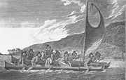
techniques along with their unique outrigger canoe
Outrigger canoe
The outrigger canoe is a type of canoe featuring one or more lateral support floats known as outriggers, which are fastened to one or both sides of the main hull...
construction methods have been kept as guild
Guild
A guild is an association of craftsmen in a particular trade. The earliest types of guild were formed as confraternities of workers. They were organized in a manner something between a trade union, a cartel, and a secret society...
secrets. Generally each island maintained a guild of navigators who had very high status and in times of famine or difficulty these navigators could trade for aid or evacuate people to neighboring islands. To this day, the original methods of Polynesian Navigation are still taught in the Polynesian outlier
Polynesian outlier
Polynesian outliers are a number of culturally Polynesian islands which lie in geographic or political Melanesia and Micronesia. Based on archaeological and linguistic analysis, these islands are believed to have been colonized by seafaring Polynesians, mostly from the area of Tonga, Samoa and...
of Taumako Island
Duff Islands
The Duff Islands are a small island group lying to the northeast of the Santa Cruz Islands in the Solomon Islands province of Temotu. They are also sometimes known as the Wilson Islands....
in the Solomon Islands
Islands of the Solomon Islands
This is a list of islands of the Solomon Islands, by province and archipelago.*Choiseul Province**Choiseul Island**Taro Island**Vaghena Island *Western Province**Shortland Islands***Magusaiai***Alu Island ***Pirumeri...
.
History

Taiwan
Taiwan , also known, especially in the past, as Formosa , is the largest island of the same-named island group of East Asia in the western Pacific Ocean and located off the southeastern coast of mainland China. The island forms over 99% of the current territory of the Republic of China following...
, as tribes whose natives
Taiwanese aborigines
Taiwanese aborigines is the term commonly applied in reference to the indigenous peoples of Taiwan. Although Taiwanese indigenous groups hold a variety of creation myths, recent research suggests their ancestors may have been living on the islands for approximately 8,000 years before major Han...
were thought to have previously arrived about from mainland South China about 8000 years ago – into the edges of western Micronesia
Micronesia
Micronesia is a subregion of Oceania, comprising thousands of small islands in the western Pacific Ocean. It is distinct from Melanesia to the south, and Polynesia to the east. The Philippines lie to the west, and Indonesia to the southwest....
and on into Melanesia
Melanesia
Melanesia is a subregion of Oceania extending from the western end of the Pacific Ocean to the Arafura Sea, and eastward to Fiji. The region comprises most of the islands immediately north and northeast of Australia...
. In the archaeological record there are well-defined traces of this expansion which allow the path it took to be followed and dated with a degree of certainty. In the mid 2nd millennium BC a distinctive culture appeared suddenly in north-west Melanesia, in the Bismarck Archipelago
Bismarck Archipelago
The Bismarck Archipelago is a group of islands off the northeastern coast of New Guinea in the western Pacific Ocean and is part of the Islands Region of Papua New Guinea.-History:...
, the chain of islands forming a great arch from New Britain
New Britain
New Britain, or Niu Briten, is the largest island in the Bismarck Archipelago of Papua New Guinea. It is separated from the island of New Guinea by the Dampier and Vitiaz Straits and from New Ireland by St. George's Channel...
to the Admiralty Islands
Admiralty Islands
The Admiralty Islands are a group of eighteen islands in the Bismarck Archipelago, to the north of New Guinea in the south Pacific Ocean. These are also sometimes called the Manus Islands, after the largest island. These rainforest-covered islands form part of Manus Province, the smallest and...
. This culture, known as Lapita
Lapita
Lapita is a term applied to an ancient Pacific Ocean archaeological culture which is believed by many archaeologists to be the common ancestor of several cultures in Polynesia, Micronesia, and some coastal areas of Melanesia...
, stands out in the Melanesian archeological record, with its large permanent villages on beach terraces along the coasts. Particularly characteristic of the Lapita culture is the making of pottery, including a great many vessels of varied shapes, some distinguished by fine patterns and motifs pressed into the clay. Within a mere three or four centuries between about 1300 and 900 BC, the Lapita culture spread 6000 km further to the east from the Bismarck Archipelago, until it reached as far as Tonga
Tonga
Tonga, officially the Kingdom of Tonga , is a state and an archipelago in the South Pacific Ocean, comprising 176 islands scattered over of ocean in the South Pacific...
and Samoa
Samoa
Samoa , officially the Independent State of Samoa, formerly known as Western Samoa is a country encompassing the western part of the Samoan Islands in the South Pacific Ocean. It became independent from New Zealand in 1962. The two main islands of Samoa are Upolu and one of the biggest islands in...
. In this region, the distinctive Polynesian culture developed.
Pre-Columbian contact with the Americas
In the mid-twentieth century, Thor HeyerdahlThor Heyerdahl
Thor Heyerdahl was a Norwegian ethnographer and adventurer with a background in zoology and geography. He became notable for his Kon-Tiki expedition, in which he sailed by raft from South America to the Tuamotu Islands...
proposed a new theory of Polynesian origins (one which did not win general acceptance), arguing that the Polynesians had migrated from South America on balsa
Balsa
Ochroma pyramidale, commonly known as the balsa tree , is a species of flowering plant in the mallow family, Malvaceae. It is a large, fast-growing tree that can grow up to tall. It is the source of balsa wood, a very lightweight material with many uses...
-log boats.
The presence in the Cook Islands
Cook Islands
The Cook Islands is a self-governing parliamentary democracy in the South Pacific Ocean in free association with New Zealand...
of the kumara (sweet potato
Sweet potato
The sweet potato is a dicotyledonous plant that belongs to the family Convolvulaceae. Its large, starchy, sweet-tasting, tuberous roots are an important root vegetable. The young leaves and shoots are sometimes eaten as greens. Of the approximately 50 genera and more than 1,000 species of...
), a plant native to the Americas, and dating to 1000 AD, has been cited as evidence that Americans could have traveled to Oceania. An alternative explanation posits biological dispersal
Biological dispersal
Biological dispersal refers to species movement away from an existing population or away from the parent organism. Through simply moving from one habitat patch to another, the dispersal of an individual has consequences not only for individual fitness, but also for population dynamics, population...
; plants and/or seeds could float across the Pacific without any human contact.
A 2007 study published in the Proceedings of the National Academy of Sciences
Proceedings of the National Academy of Sciences
The Proceedings of the National Academy of Sciences of the United States of America, usually referred to as PNAS, is the official journal of the United States National Academy of Sciences...
of chicken
Chicken
The chicken is a domesticated fowl, a subspecies of the Red Junglefowl. As one of the most common and widespread domestic animals, and with a population of more than 24 billion in 2003, there are more chickens in the world than any other species of bird...
bones at El Arenal near the Arauco Peninsula, Arauco Province
Arauco Province
Arauco Province is one of four provinces of the Chilean region of Biobío . It spans a coastal area of just south of the mouth of the Biobío River, the traditional demarcation between the nation's major natural regions, Zona Central and Zona Sur...
, Chile
Chile
Chile ,officially the Republic of Chile , is a country in South America occupying a long, narrow coastal strip between the Andes mountains to the east and the Pacific Ocean to the west. It borders Peru to the north, Bolivia to the northeast, Argentina to the east, and the Drake Passage in the far...
suggested Oceania-to-America contact. Chickens originated in southern Asia and the Araucana breed of Chile was thought to have been brought by Spaniards around 1500. However, the bones found in Chile were radiocarbon-dated to between 1304 and 1424, well before the documented arrival of the Spanish. DNA sequences taken were exact matches to those of chickens from the same period in American Samoa
American Samoa
American Samoa is an unincorporated territory of the United States located in the South Pacific Ocean, southeast of the sovereign state of Samoa...
and Tonga
Tonga
Tonga, officially the Kingdom of Tonga , is a state and an archipelago in the South Pacific Ocean, comprising 176 islands scattered over of ocean in the South Pacific...
, both over 5000 miles (8000 kilometers) away from Chile. The genetic sequences were also similar to those found in Hawaii and Easter Island, the closest island at only 2500 miles (4000 kilometers), and unlike any breed of European chicken.
Although this initial report suggested a Polynesian pre-Columbian origin a later report looking at the same specimens concluded:
A published, apparently pre-Columbian, Chilean specimen and six pre-European Polynesian specimens also cluster with the same European/Indian subcontinental/Southeast Asian sequences, providing no support for a Polynesian introduction of chickens to South America. In contrast, sequences from two archaeological sites on Easter Island group with an uncommon haplogroup from Indonesia, Japan, and China and may represent a genetic signature of an early Polynesian dispersal. Modeling of the potential marine carbon contribution to the Chilean archaeological specimen casts further doubt on claims for pre-Columbian chickens, and definitive proof will require further analyses of ancient DNA sequences and radiocarbon and stable isotope data from archaeological excavations within both Chile and Polynesia.
In the last 20 years, the dates and anatomical features of human remains found in Mexico
Mexico
The United Mexican States , commonly known as Mexico , is a federal constitutional republic in North America. It is bordered on the north by the United States; on the south and west by the Pacific Ocean; on the southeast by Guatemala, Belize, and the Caribbean Sea; and on the east by the Gulf of...
and South America have led some archaeologists to propose that those regions were first populated by people who crossed the Pacific several millennia before the Ice Age
Ice age
An ice age or, more precisely, glacial age, is a generic geological period of long-term reduction in the temperature of the Earth's surface and atmosphere, resulting in the presence or expansion of continental ice sheets, polar ice sheets and alpine glaciers...
migrations; according to this theory, these Pre-Siberian American Aborigines would have been either eliminated or absorbed by the Siberian immigrants. However, current archaeological evidence for human migration to and settlement of remote Oceania (i.e., the Pacific Ocean
Pacific Ocean
The Pacific Ocean is the largest of the Earth's oceanic divisions. It extends from the Arctic in the north to the Southern Ocean in the south, bounded by Asia and Australia in the west, and the Americas in the east.At 165.2 million square kilometres in area, this largest division of the World...
eastwards of the Solomon Islands
Solomon Islands
Solomon Islands is a sovereign state in Oceania, east of Papua New Guinea, consisting of nearly one thousand islands. It covers a land mass of . The capital, Honiara, is located on the island of Guadalcanal...
) is dated to no earlier than approximately 3,500 BP
Before Present
Before Present years is a time scale used in archaeology, geology, and other scientific disciplines to specify when events in the past occurred. Because the "present" time changes, standard practice is to use AD 1950 as the origin of the age scale, reflecting the fact that radiocarbon...
; trans-Pacific contact with the Americas coinciding with or pre-dating the Beringia migrations of at least 11,500 BP is highly problematic, except for movement along intercoastal routes.
Recently, linguist Kathryn A. Klar of University of California, Berkeley
University of California, Berkeley
The University of California, Berkeley , is a teaching and research university established in 1868 and located in Berkeley, California, USA...
and archaeologist Terry L. Jones of California Polytechnic State University
California Polytechnic State University
California Polytechnic State University, or Cal Poly, is a public university located in San Luis Obispo, California, United States. The university is one of two polytechnic campuses in the 23-member California State University system....
have proposed contacts between Polynesians and the Chumash and Gabrielino of Southern California
Southern California
Southern California is a megaregion, or megapolitan area, in the southern area of the U.S. state of California. Large urban areas include Greater Los Angeles and Greater San Diego. The urban area stretches along the coast from Ventura through the Southland and Inland Empire to San Diego...
, between 500
500
Year 500 was a leap year starting on Saturday of the Julian calendar. At the time, it was known as the Year of the Consulship of Patricius and Hypatius...
and 700
700
Year 700 was a leap year starting on Thursday of the Julian calendar. The denomination 700 for this year has been used since the early medieval period, when the Anno Domini calendar era became the prevalent method in Europe for naming years.- North America :* The Mount Edziza volcanic complex...
. Their primary evidence consists of the advanced sewn-plank canoe design, which is used throughout the Polynesian Islands, but is unknown in North America — except for those two tribes. Moreover, the Chumash word for "sewn-plank canoe," tomolo'o, may have been derived from kumulaa'au, the Polynesian word for the Redwood (Sequoia sempervirens) logs used in that construction.
Polynesian contact with the prehispanic Mapuche
Mapuche
The Mapuche are a group of indigenous inhabitants of south-central Chile and southwestern Argentina. They constitute a wide-ranging ethnicity composed of various groups who shared a common social, religious and economic structure, as well as a common linguistic heritage. Their influence extended...
culture in central-south Chile has been suggested because of apparently similar cultural traits, including words like toki (stone axes and adzes), hand clubs similar to the Māori
Maori language
Māori or te reo Māori , commonly te reo , is the language of the indigenous population of New Zealand, the Māori. It has the status of an official language in New Zealand...
wahaika, the sewn-plank canoe as used on Chiloe island, the curanto earth oven (Polynesian umu) common in southern Chile, fishing techniques such as stone wall enclosures, a hockey-like game, and other potential parallels. Some strong westerlies and El Niño
El Niño-Southern Oscillation
El Niño/La Niña-Southern Oscillation, or ENSO, is a quasiperiodic climate pattern that occurs across the tropical Pacific Ocean roughly every five years...
wind blow directly from central-east Polynesia to the Mapuche region, between Concepcion and Chiloe. A direct connection from New Zealand is possible, sailing with the "roaring forties". In 1834, some escapees from Tasmania
Tasmania
Tasmania is an Australian island and state. It is south of the continent, separated by Bass Strait. The state includes the island of Tasmania—the 26th largest island in the world—and the surrounding islands. The state has a population of 507,626 , of whom almost half reside in the greater Hobart...
arrived at Chiloe Island after sailing for 43 days.
Post-colonization
Knowledge of the traditional Polynesian methods of navigation was largely lost after contact with and colonization by Europeans. This left the problem of accounting for the presence of the Polynesians in such isolated and scattered parts of the Pacific. According to Andrew SharpAndrew Sharp
Andrew Sharp is a Philippines-born ice hockey player. He is currently playing for the Guildford Flames in the English Premier Ice Hockey League ....
, the explorer Captain James Cook
James Cook
Captain James Cook, FRS, RN was a British explorer, navigator and cartographer who ultimately rose to the rank of captain in the Royal Navy...
, already familiar with Charles de Brosse’s accounts of large groups of Pacific islanders who were driven off course in storms and ended up hundreds of miles away with no idea where they were, encountered in the course of one of his own voyages a castaway group of Tahitians who had become lost at sea in a gale and blown 100 miles away to the island of Atiu. Cook wrote that the Atiu incident, "will serve to explain, better than the thousand conjectures of speculative reasoners, how the detached parts of the earth, and, in particular, how the South Seas, may have been peopled". On his first voyage of Pacific exploration Cook had the services of a Polynesian navigator, Tupaia
Tupaia (navigator)
Tupaia was a Polynesian navigator and arioi , originally from the island of Ra'iatea in the Pacific Islands group known to Europeans as the Society Islands. His remarkable navigational skills and Pacific geographical knowledge were to be utilised by Lt. James Cook, R.N...
, who drew a map of the islands within 2000 miles (3,218.7 km) radius (to the north and west) of his home island of Ra'iatea.
By the late 19th century to the early 20th century a more generous view of Polynesian navigation had come into favor, creating a much romanticized view of their seamanship, canoes, and navigational expertise. Late nineteenth and early twentieth century writers such as Abraham Fornander
Abraham Fornander
Abraham Fornander was a Swedish-born emigrant who became an important Hawaiian journalist, judge, and ethnologist.-Early life and education:...
and Stephenson Percy Smith
Stephenson Percy Smith
Stephenson Percy Smith was a New Zealand ethnologist and surveyor. He founded The Polynesian Society.-Early life and career as a surveyor :...
told of heroic Polynesians migrating in great coordinated fleets from Asia far and wide into present-day Polynesia.
Experimental research
A more sober and analytical view was presented by Andrew Sharp, who amassed a wealth of evidence to challenge the ‘heroic vision’ hypothesis, asserting instead that Polynesian maritime expertise was severely limited in the field of exploration and that as a result the settlement of Polynesia had been the result of luck, random island sightings, and drifting, rather than as organized voyages of colonization. Thereafter the oral knowledge passed down for generations allowed for eventual mastery of traveling between known locations. Sharp's reassessment caused a huge amount of controversy and led to a stalemate between the romantic and the skeptical views.By the mid to late 1960s it was time for a new hands-on approach. Anthropologist David Lewis
David Henry Lewis
David Henry Lewis, DCNZM was a sailor, adventurer, doctor, and Polynesian scholar. He is best known for his studies on the traditional systems of navigation used by the Pacific Islanders...
sailed his catamaran from Tahiti to New Zealand using stellar navigation without instruments. Anthropologist and historian Ben Finney
Ben Finney
Ben Rudolph Finney is an American anthropologist known for his expertise in the history and cultural and social anthropology of surfing, Polynesian navigation and canoe sailing, and in the cultural and social anthropology of human space colonization...
built Nalehia, a 40 feet (12.2 m) replica of a Hawaiian double canoe
Outrigger canoe
The outrigger canoe is a type of canoe featuring one or more lateral support floats known as outriggers, which are fastened to one or both sides of the main hull...
. Finney tested the canoe in a series of sailing and paddling experiments in Hawaiian waters. At the same time, ethnographic research in the Caroline Islands in Micronesia
Micronesia
Micronesia is a subregion of Oceania, comprising thousands of small islands in the western Pacific Ocean. It is distinct from Melanesia to the south, and Polynesia to the east. The Philippines lie to the west, and Indonesia to the southwest....
brought to light the fact that traditional stellar navigational methods were still very much in everyday use there. The building and testing of canoes inspired by traditional designs, the harnessing of knowledge from skilled Micronesian, as well as voyages using stellar navigation, allowed practical conclusions about the seaworthiness and handling capabilities of traditional Polynesian canoes and allowed a better understanding of the navigational methods that were likely to have been used by the Polynesians and of how they, as people, were adapted to seafaring. Recent re-creations of Polynesian voyaging have used methods based largely on Micronesian methods and the teachings of a Micronesian navigator, Mau Piailug
Mau Piailug
Pius "Mau" Piailug was a Micronesian navigator from the Carolinian island of Satawal, best known as a teacher of traditional, non-instrument wayfinding methods for deep-sea voyaging...
.
Polynesian navigators employed a whole range of techniques including use of the stars, the movement of ocean currents and wave patterns, the air and sea interference patterns caused by islands and atoll
Atoll
An atoll is a coral island that encircles a lagoon partially or completely.- Usage :The word atoll comes from the Dhivehi word atholhu OED...
s, the flight of birds, the winds and the weather.
Scientists think that long-distance Polynesian voyaging followed the seasonal paths of birds
Bird migration
Bird migration is the regular seasonal journey undertaken by many species of birds. Bird movements include those made in response to changes in food availability, habitat or weather. Sometimes, journeys are not termed "true migration" because they are irregular or in only one direction...
. There are some references in their oral traditions to the flight of birds and some say that there were range marks onshore pointing to distant islands in line with these flyway
Flyway
A flyway is a flight path used in bird migration. Flyways generally span over continents and often oceans.-Flyways of the Americas:*Atlantic Flyway*Central Flyway*Mississippi Flyway*Pacific Flyway*Allegheny Front...
s. A voyage from Tahiti, the Tuamotus or the Cook Islands to New Zealand might have followed the migration of the Long-tailed Cuckoo
Long-tailed Cuckoo
The Long-tailed Cuckoo , also known as the Long-tailed Koel or the Koekoeā in Māori, is a species of cuckoo in the Cuculidae family...
(Eudynamys taitensis) just as the voyage from Tahiti to Hawaii would coincide with the track of the Pacific Golden Plover
Pacific Golden Plover
The Pacific Golden Plover is a medium-sized plover.The 23–26 cm long breeding adult is spotted gold and black on the crown, back and wings. Its face and neck are black with a white border and it has a black breast and a dark rump. The legs are black...
(Pluvialis fulva) and the Bristle-thighed Curlew
Bristle-thighed Curlew
The Bristle-thighed Curlew, Numenius tahitiensis, is a large shorebird that breeds in Alaska and winters on tropical Pacific islands. It has a long, decurved bill and bristled feathers at the base of the legs. Its length is about 43 cm and wingspan about 84 cm...
(Numenius tahitiensis). It is also believed that Polynesians employed shore-sighting birds as did many seafaring peoples. One theory is that they would have taken a frigatebird
Frigatebird
The frigatebirds are a family, Fregatidae, of seabirds. There are five species in the single genus Fregata. They are also sometimes called Man of War birds or Pirate birds. Since they are related to the pelicans, the term "frigate pelican" is also a name applied to them...
(Fregata) with them. These birds refuse to land on the water as their feathers will become waterlogged making it impossible to fly. When the voyagers thought they were close to land they may have released the bird, which would either fly towards land or else return to the canoe.
The peoples of the Pacific, including Micronesians and Polynesians, developed navigating by the stars into a fine art. They had names for over a hundred and fifty stars. A navigator would have known where and when a given star rose and set, as well as which islands it passed directly over. Thus Polynesian navigators would have then been able to sail toward the star they knew to be over their destination, and as it moved westward with time they would then set their course by the succeeding star which would have then moved over the target island.
It is likely that the Polynesians also used wave and swell formations to navigate. Many of the habitable areas of the Pacific Ocean are groups of islands (or atolls) in chains hundreds of kilometers long. Island chains have predictable effects on waves and on currents. Navigators who lived within a group of islands would learn the effect various islands had on their shape, direction, and motion and would have been able to correct their path in accordance with the changes they perceived. When they arrived in the vicinity of a chain of islands they were unfamiliar with, they may have been able to transfer their experience and deduce that they were nearing a group of islands. Once they had arrived fairly close to a destination island, they would have been able to pinpoint its location by sightings of land-based birds, certain cloud formations, as well as the reflections shallow water made on the undersides of clouds. It is thought that the Polynesian navigators may have measured the time it took to sail between islands in "canoe-days" or a similar type of expression.
The first settlers of the Hawaiian Islands
Hawaiian Islands
The Hawaiian Islands are an archipelago of eight major islands, several atolls, numerous smaller islets, and undersea seamounts in the North Pacific Ocean, extending some 1,500 miles from the island of Hawaii in the south to northernmost Kure Atoll...
are thought to have sailed from the Marquesas Islands
Marquesas Islands
The Marquesas Islands enana and Te Fenua `Enata , both meaning "The Land of Men") are a group of volcanic islands in French Polynesia, an overseas collectivity of France in the southern Pacific Ocean. The Marquesas are located at 9° 00S, 139° 30W...
using Polynesian navigation methods. To test this theory, the Hawaiian Polynesian Voyaging Society
Polynesian Voyaging Society
The Polynesian Voyaging Society is a non-profit research and educational corporation based in Honolulu, Hawaii. PVS was established to research and perpetuate traditional Polynesian voyaging methods...
was established in 1973. The group built a replica of an ancient double-hulled canoe called the Hōkūle‘a
Hokulea
Hōkūlea is a performance-accurate full-scale replica of a waa kaulua, a Polynesian double-hulled voyaging canoe. Launched on 8 March 1975 by the Polynesian Voyaging Society, she is best known for her 1976 Hawaii to Tahiti voyage performed with Polynesian navigation techniques, without modern...
, whose crew successfully navigated the Pacific Ocean from Hawaii
Hawaii
Hawaii is the newest of the 50 U.S. states , and is the only U.S. state made up entirely of islands. It is the northernmost island group in Polynesia, occupying most of an archipelago in the central Pacific Ocean, southwest of the continental United States, southeast of Japan, and northeast of...
to Tahiti
Tahiti
Tahiti is the largest island in the Windward group of French Polynesia, located in the archipelago of the Society Islands in the southern Pacific Ocean. It is the economic, cultural and political centre of French Polynesia. The island was formed from volcanic activity and is high and mountainous...
in 1976 without instruments. In 1980, a Hawaiian named Nainoa Thompson
Nainoa Thompson
Charles Nainoa Thompson is a Native Hawaiian navigator and the executive director of the Polynesian Voyaging Society...
invented a new method of non instrument navigation
Wayfinding
Wayfinding encompasses all of the ways in which people and animals orient themselves in physical space and navigate from place to place.-Historical:...
(called the "modern Hawaiian wayfinding system"), enabling him to complete the voyage from Hawaii to Tahiti
Tahiti
Tahiti is the largest island in the Windward group of French Polynesia, located in the archipelago of the Society Islands in the southern Pacific Ocean. It is the economic, cultural and political centre of French Polynesia. The island was formed from volcanic activity and is high and mountainous...
and back. In 1987, a Māori named Matahi Whakataka (Greg Brightwell) and his mentor Francis Cowan sailed from Tahiti to Aotearoa
Aotearoa
Aotearoa is the most widely known and accepted Māori name for New Zealand. It is used by both Māori and non-Māori, and is becoming increasingly widespread in the bilingual names of national organisations, such as the National Library of New Zealand / Te Puna Mātauranga o Aotearoa.-Translation:The...
without instruments.
In New Zealand
New Zealand
New Zealand is an island country in the south-western Pacific Ocean comprising two main landmasses and numerous smaller islands. The country is situated some east of Australia across the Tasman Sea, and roughly south of the Pacific island nations of New Caledonia, Fiji, and Tonga...
, a leading Māori navigator and ship builder is Hector Busby
Hector Busby
Hector Busby is a Māori navigator and traditional ship builder in New Zealand...
who was also inspired and influenced by Nainoa Thompson and Hokulea's voyage there in 1985.
External links
- Wayfinding Summary
- Wayfinding Main Page
- ExploratoriumExploratoriumThe Exploratorium is a museum in San Francisco with over 475 participatory exhibits, all of them made onsite, that mix science and art. It also aims to promote museums as informal education centers....
Never Lost exhibit and site