

Islands of the Solomon Islands
Encyclopedia
Solomon Islands
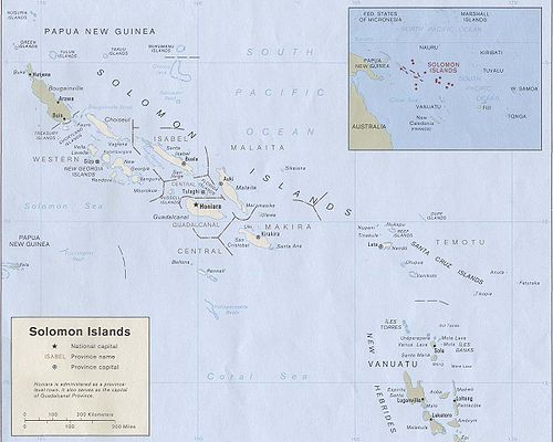
Solomon Islands is a sovereign state in Oceania, east of Papua New Guinea, consisting of nearly one thousand islands. It covers a land mass of . The capital, Honiara, is located on the island of Guadalcanal...
, by province
Provinces of the Solomon Islands
Solomon Islands is currently divided into 9 provinces. The national capital, Honiara, on the island of Guadalcanal, is separately governed as Capital Territory.-History:...
and archipelago
Archipelago
An archipelago , sometimes called an island group, is a chain or cluster of islands. The word archipelago is derived from the Greek ἄρχι- – arkhi- and πέλαγος – pélagos through the Italian arcipelago...
.
- Choiseul ProvinceChoiseul ProvinceThe Choiseul Province is one of the nine provinces of the Solomon Islands. It lies between the island of Bougainville and Santa Isabel in the west of the Solomon Islands....
- Choiseul IslandChoiseul IslandChoiseul Island, native name Lauru, is the largest island of the Choiseul Province, Solomon Islands, at .-Description:This island is named after Étienne François, duc de Choiseul....
- Taro IslandTaro IslandTaro Island is a small island in the Solomon Islands with 507 inhabitants, capital of Choiseul Province and is located in Choiseul Bay off the northwest coast....
- Vaghena IslandVaghena IslandWagina Island, or as it used to be misspelled in colonial times Vaghena Island is a small community in the Solomon Islands with 320 inhabitants, most of whom live along the shores of the Kenli Bay, where a small docking station is built for both residents and visitors.There are three villages in...
(Vaglena, Wagina)
- Choiseul Island
- Western ProvinceWestern Province (Solomon Islands)Western Province is the largest of the provinces of the Solomon Islands. The area is renowned for its beautiful tropical islands, excellent diving and snorkelling, coral reefs and WWII wrecks, ecotourism lodges, and head-hunting shrines...
- Shortland IslandsShortland IslandsThe Shortland Islands are group of islands belonging to the Western Province of the Solomon Islands, at . Named by John Shortland, they lie in the extreme northwest of the country's territory, close to the island of Bougainville, Papua New Guinea. The largest island is Shortland Island...
- Magusaiai
- Alu Island (Shortland)
- Pirumeri
- Fauro IslandFauro IslandFauro Island is an island, part of the Shortland Islands, Solomon Islands, located at ....
- Masamasa
- Ovau
- Treasury IslandsTreasury IslandsTreasury Islands are a small group of islands a few kilometers to the south of Bougainville and 24 kilometers from the Shortland Islands. They form part of the Western Province of the Solomon Islands. The two largest islands in the Treasuries are Mono Island and the smaller Stirling Island...
- Mono IslandMono IslandMono Island is the largest island of the Treasury Islands, Solomon Islands, at .- Geography :Mono island is a volcanic island in the northwest of the Solomon Islands. It is separated by the Blanche Harbour from Stirling Island and the other coral islands surrounding it. The village of Falamai is...
- Stirling IslandStirling IslandStirling Island is the smaller island of the Treasury Islands, Solomon Islands, at . It is separated from the largest Mono Island by Blanche Harbor. Stirling Island is composed of coral which was once part of the barrier reef surrounding Mono Island....
- Mono Island
- New Georgia Group
- Vella LavellaVella LavellaVella Lavella is an island in the Western Province of the Solomon Islands. It lies to the west of New Georgia, but is considered one of the New Georgia Group...
- MbavaMbavaMbava is an island in the Solomon Islands; it is located in the Western Province....
- RanonggaRanonggaRanongga is an island located in the New Georgia Islands group of Western Province, Solomon Islands.-History:Ranongga was sighted in 1787 by sailors Read and Dale....
(Ghanongga) - SimboSimboSimbo is an island in the Solomon Islands; it is located in the Western Province. It was known to early Europeans as Eddystone Island. Simbo is actually two main islands, one small island called Nusa Simbo separated by a saltwater lagoon from a larger one...
- Ghizo IslandGhizo IslandGhizo Island, home to Gizo the capital of the Western Province, Solomon Islands. The island is named after an infamous local head-hunter. It is located west of New Georgia and Kolombangara....
- KolombangaraKolombangaraKolombangara is an island in the New Georgia Islands group of the Solomon Islands in the southwestern Pacific Ocean...
(Kilimbangara) - VonavonaVonavonaVonavona is an island in the Solomon Islands; it is located in the Western Province....
- KohinggoKohinggoKohinggo is an island in the Solomon Islands; it is located in the Western Province....
- New GeorgiaNew GeorgiaNew Georgia is the largest island of the Western Province of the Solomon Islands.-Geography:This island is located in the New Georgia Group, an archipelago including most of the other larger islands in the province...
- Tetepare
- Akara
- Rendova
- VangunuVangunuVangunu Island is an island, part of the New Georgia Islands in the Solomon Islands. It is located between New Georgia and Nggatokae Island, at , between the islands of New Georgia and Nggatokae. In the north of the island is Lake Marovo, the largest salt water in the world....
- Penjuku
- Nggatokae
- MborokuaMborokuaMborokua is an uninhabited, jungle-covered volcanic island 30 km west of the Russell Islands. It is occasionally visited by local fishermen, as well as by dive tours.-External links:* from Google Maps...
- Vella Lavella
- Shortland Islands
- Isabel ProvinceIsabel ProvinceIsabel Province is one of the provinces of the Solomon Islands. It has a population of around 30,000 . The capital is Buala on Santa Isabel Island.Santa Isabel is the longest Island in the Solomon Islands, South Pacific...
- Santa IsabelSanta Isabel IslandSanta Isabel Island is the longest in the Solomon Islands, South Pacific, and the largest in the group of islands in Isabel Province.-Location and geographic data:...
- San JorgeSan Jorge IslandSan Jorge Island is the second largest island in the Isabel Province, Solomon Islands. The island lies at the southern end of Santa Isabel Island and borders Thousand Ships Bay. San Jorge has an area of 184 km² and has less than 1000 inhabitants living in four villages....
- Santa Isabel
- Central ProvinceCentral Province (Solomon Islands)The Central Province is one of the provinces of the Solomon Islands, covering the Russell Islands, Nggela Islands and Savo Island. Its area comprises 615 km² and had a population of 21,577 as of 1999. The capital is Tulagi.-Islands:*Aeaun...
- Russell IslandsRussell IslandsThe Russell Islands are two small islands, as well as several islets, of volcanic origin, in the Central Province of the Solomon Islands. They are located approximately 48 km northwest from Guadalcanal. The islands are partially covered in coconut plantations, and have a copra and oil factory at...
- Florida IslandsFlorida IslandsThe Nggela Islands, also known as the Florida Islands, are a small island group in the Central Province of the Solomon Islands, a state in the southwest Pacific Ocean....
(Nggela)- Nggela Sule (Florida Island)
- TulagiTulagiTulagi, less commonly Tulaghi, is a small island in the Solomon Islands, just off the south coast of Florida Island. The town of the same name on the island Tulagi, less commonly Tulaghi, is a small island (5.5 km by 1 km) in the Solomon Islands, just off the south coast of Florida...
(Tulaghi) - GavutuGavutuGavutu is a small islet in the Central Province of the Solomon Islands, some 500 metres in length. It is one of the Nggela Islands....
- TanambogoTanambogoTanambogo is an islet in the Central Province of the Solomon Islands. It is one of the Florida Islands.Along with the nearby island of Gavutu, it played an important role in the Guadalcanal campaign during World War II. In 1942 the Japanese attempted to establish a seaplane base on the island. On...
- Russell Islands
- Guadalcanal ProvinceGuadalcanal ProvinceGuadalcanal Province is one of the provinces of the Solomon Islands, consisting of the island of Guadalcanal. It is a 2,510 square mile island and is largely a jungle. Its name was given by Pedro de Ortega Valencia, born in the village of Guadalcanal in Seville, Spain...
- GuadalcanalGuadalcanalGuadalcanal is a tropical island in the South-Western Pacific. The largest island in the Solomons, it was discovered by the Spanish expedition of Alvaro de Mendaña in 1568...
- Guadalcanal
- Malaita ProvinceMalaita ProvinceMalaita Province is one of the largest provinces of the Solomon Islands. It is named for its largest island, Malaita . Other islands include South Malaita Island , Sikaiana Island, and Ontong Java Atoll. The provincial capital and largest urban center is Auki, located on Big Malaita...
- MalaitaMalaitaMalaita is the largest island of the Malaita Province in the Solomon Islands. A tropical and mountainous island, Malaita's pristine river systems and tropical forests have not been exploited. Malaita is the most populous island of the Solomon Islands, with 140,000 people or more than a third of the...
- Maramasike (South Malaita, Small Malaita)
- Stewart Islands
- Mutuavi
- Faore
- SikaianaSikaianaSikaiana formerly called Stewart Islands is a small atoll 212 km NE of Malaita. It is almost 14 km in length and its lagoon, known as Te Moana, is totally enclosed by the coral reef. Its total land surface is only 2 km2...
- Ontong Java AtollOntong Java AtollOntong Java Atoll or Luangiua is one of the largest atolls on earth. It is sometimes referred to as Lord Howe Atoll, not to be confused with Lord Howe Island.-Description:Administratively Ontong Java belongs to the Solomon Islands...
(Ongtong Java, Lord Howe Atoll) - Roncador ReefRoncador ReefRoncador Reef is a reef in the Solomon Islands, south of Ontong Java Atoll and north of Santa Isabel Island. Its coordinates are ....
- Malaita
- Makira-Ulawa ProvinceMakira-Ulawa ProvinceMakira-Ulawa Province is one of the provinces of the Solomon Islands. The main part of the province is Makira Island. It has a population of 31,006...
- MakiraMakiraThe island of Makira is the largest island of Makira-Ulawa Province in the Solomon Islands. The island is located east of Guadalcanal and south of Malaita. The largest and capital city is Kirakira....
(San Cristobal) - Olu Malau Islands (Three Sisters Islands)
- MalaulaloMalaulaloMalaulalo is an island in the Solomon Islands; it is one of the Olu Malau Islands located in Makira-Ulawa Province....
- MalaupainaMalaupainaMalaupaina is an island in the Solomon Islands; it is one of the Olu Malau Islands located in Makira-Ulawa Province....
- Ali'iteAli'iteAli'ite is an island in the Solomon Islands; it is one of the Olu Malau Islands located in Makira-Ulawa Province....
- Malaulalo
- Ulawa
- Uki Ni MasiUki Ni MasiUki Ni Masi is an island that is part of the Solomon Islands. It is 150 km² in size and the highest hills are up to 200 m high.The only mammals that live there were introduced by man like the Polynesian rat and bats Dobsonia inermis, Pteropus cognatus, Emballonura nigrescens and Aselliscus...
- OwarahaOwarahaOwaraha or Owa Raha is an island in the Solomon Islands; it is located in Makira-Ulawa Province.-Description:This relatively small coral island is 5,6 km long and 4, 5 km wide. It is located at the eastern end of Makira , separated from it by a 7,5 km wide strait, and just north of smaller Owariki...
(Santa Ana) - OwarikiOwarikiOwariki or Owa Riki is an island in the Solomon Islands; it is located in Makira-Ulawa Province.-Description:...
(Santa Catalina)
- Makira
- Rennell and Bellona Province
- Rennell
- BellonaBellona IslandBellona Island is an island of the Rennell and Bellona Province, Solomon Islands. Its length is about 10 km and its average width 2.5 km. Its area is about 17 km². It is almost totally surrounded by 30–70 m high cliffs, consisting primarily of raised coral...
- Indispensable Reefs
- North ReefNorth ReefNorth Reef is a shallow reef south of the island of Rennell....
- Middle Reef
- Nottingham Islet
- South Reef
- North Reef
- Temotu ProvinceTemotu ProvinceTemotu is the easternmost province of the Solomon Islands. The province was formerly known as Santa Cruz Islands Province. It consists, essentially, of two chains of islands which run parallel to each other from the northwest to the southeast.- Islands :...
- Santa Cruz IslandsSanta Cruz IslandsThe Santa Cruz Islands are a group of islands in the Pacific Ocean, part of Temotu Province of the Solomon Islands. They lie approximately 250 miles to the southeast of the Solomon Islands Chain...
- Nendo (Ndeni, Nitendi, Ndende, Santa Cruz)
- Temotu Neo
- Temotu Noi
- Utupua
- VanikoroVanikoroVanikoro is an island from the Santa Cruz group, located 118 km to the Southeast of the main Santa Cruz group. It belongs administratively to the Temotu Province of the Solomon Islands....
- BanieBanie (island)Banie is the main island of the Vanikoro group, in the Temotu province of the Solomon Islands. The only other inhabited island of the group is the smaller island of Teanu ou Tevai.-Name:...
- TeanuTeanu (island)Teanu is the second island in size of the Vanikoro group, in the Temotu province of the Solomon Islands. It is located northeast of the main island of the group, Banie.Teanu has currently only one inhabited village, Puma....
(Tevai)
- Banie
- TinakulaTinakulaTinakula is a conical stratovolcano which forms an island north of Nendo in Temotu Province, the Solomon Islands. It lies at the north end of the Santa Cruz Islands. It is about 3.5 km wide and rises 851 m above sea level, but rises three or four km above the sea floor. It erupts...
- Nendo (Ndeni, Nitendi, Ndende, Santa Cruz)
- Reef IslandsReef IslandsThe Reef Islands are a loose collection of 16 islands in the northwestern part of the Solomon Islands province of Temotu. These islands have historically also been known by the names of Swallow Islands and Matema Islands....
- Duff IslandsDuff IslandsThe Duff Islands are a small island group lying to the northeast of the Santa Cruz Islands in the Solomon Islands province of Temotu. They are also sometimes known as the Wilson Islands....
(Pileni Taumako)- TaumakoTaumakoTaumako is the largest of the Duff Islands. This 5.7 km long island has steep sides and rises to a height of 400 m above sea level. It is composed of basaltic lavas and pyroclastics like the other islands in the Duffs ....
- TaumakoTaumakoTaumako is the largest of the Duff Islands. This 5.7 km long island has steep sides and rises to a height of 400 m above sea level. It is composed of basaltic lavas and pyroclastics like the other islands in the Duffs ....
- Tahua
- Tohua
- Taumako
- Bass IslandsBass IslandsThe Bass Islands are three American islands in the western half of Lake Erie. They are north of Sandusky, Ohio and south of Pelee Island, Ontario. South Bass Island is the largest of the islands, followed closely by North Bass Island and Middle Bass Island . They are located in Ottawa County in...
- Lua
- Kaa
- Loreva
- Treasurer's Islands
- Tuleki
- Te Aku
- Lakao
- Ulaka
- Hallie Jackson Reef
- Taumako
- TikopiaTikopiaTikopia is a small and high island in the southwestern Pacific Ocean. Covering an area of 5 km² , the island is the remnant of an extinct volcano. Its highest point, Mt. Reani, reaches an elevation of 380 m above sea level. Lake Te Roto covers an old volcanic crater which is 80 m...
- AnutaAnutaAnuta is a small high island in the southeastern part of the Solomon Islands province of Temotu, the smallest permanently inhabited isolated Polynesian island.-Description:...
(Anua) - FatutakaFatutakaFatutaka, Fatu Taka or Patu Taka is a small high island in the Solomon Islands province of Temotu. It is the easternmost landfall in that nation. The island, located at , is the remnant of an extinct volcano. It is a small rocky outcropping, rising to an elevation of . The total land area of the...
- Santa Cruz Islands