
Apsley Falls
Encyclopedia
Waterfall
A waterfall is a place where flowing water rapidly drops in elevation as it flows over a steep region or a cliff.-Formation:Waterfalls are commonly formed when a river is young. At these times the channel is often narrow and deep. When the river courses over resistant bedrock, erosion happens...
s on the Apsley River
Apsley River (New South Wales)
The Apsley River is a river on the Northern Tablelands of New South Wales, Australia. The headwaters of the river rise in high country about 11 kilometres west of Tia and approximately 29 km south of Walcha, New South Wales.- Geography :...
on the Northern Tablelands, New South Wales
Northern Tablelands, New South Wales
The Northern Tablelands, also known as the New England Tableland, is a plateau and a region of the Great Dividing Range in northern New South Wales, Australia. It includes the New England Range, the narrow highlands area of the New England region, stretching from the Moonbi Range in the south to...
, Australia
Australia
Australia , officially the Commonwealth of Australia, is a country in the Southern Hemisphere comprising the mainland of the Australian continent, the island of Tasmania, and numerous smaller islands in the Indian and Pacific Oceans. It is the world's sixth-largest country by total area...
. The falls are located about 20 kilometres (12 mi) east of Walcha
Walcha, New South Wales
Walcha is a parish and town at the south-eastern edge of the Northern Tablelands, New South Wales, Australia.The town serves as the seat of Walcha Shire. Walcha is located 425 kilometres by road from Sydney at the intersection of the Oxley Highway and Thunderbolts Way...
, and 1 kilometre off the Oxley Highway
Oxley Highway
The Oxley Highway is a rural highway in New South Wales, Australia. It starts at Nevertire where it joins the Mitchell Highway. It links Warren, Gilgandra, Coonabarabran, Gunnedah, Carroll, Tamworth, Bendemeer, Walcha, Yarrowitch, Ellenborough, Long Flat, Wauchope and ends at Port Macquarie on the...
in a deep gorge, that is part of the Oxley Wild Rivers National Park
Oxley Wild Rivers National Park
Oxley Wild Rivers National Park is in New South Wales, Australia, 445 kilometres north of Sydney and is named in memory of the Australian explorer John Oxley, who passed through the area in 1818...
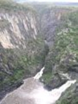
. They are the first falls in a succession of dramatic drops in an area that has some of the most remarkable scenery in Eastern Australia. The first drop of the Falls is about 65 metres (213 ft) in depth, and the second, which is about 800 metres (2,625 ft) further on, plummets 58 metres (190 ft) metres to the bottom of the gorge.
History
AboriginalIndigenous Australians
Indigenous Australians are the original inhabitants of the Australian continent and nearby islands. The Aboriginal Indigenous Australians migrated from the Indian continent around 75,000 to 100,000 years ago....
people tell the story of how the Rainbow Serpent created the gorge at Apsley Falls in the Dreamtime
Dreamtime
In the animist framework of Australian Aboriginal mythology, The Dreaming is a sacred era in which ancestral Totemic Spirit Beings formed The Creation.-The Dreaming of the Aboriginal times:...
. The Rainbow Serpent is said to travel underground from the base of the falls to reappear 20 km upstream at the Mill Hole on the Apsley River in Walcha. The site is now marked at the Mill Hole by the Rainbow Serpent mosaic made with the help of the local Aboriginal community.
Apart from Aboriginal
Indigenous Australians
Indigenous Australians are the original inhabitants of the Australian continent and nearby islands. The Aboriginal Indigenous Australians migrated from the Indian continent around 75,000 to 100,000 years ago....
significance of the area as a meeting place, John Oxley
John Oxley
John Joseph William Molesworth Oxley was an explorer and surveyor of Australia in the early period of English colonisation.October 1802 he was engaged in coastal survey work including an expedition to Western Port in 1804-05...
passed by the falls on 13 September 1818 and he named them the Bathurst Falls. He described it as “one of the most magnificent waterfalls we have seen”.
Oxley named the Apsley River and wrote in his journal that he was "lost in astonishment at the sight of this wonderful natural sublimity".
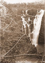
In 1902 three men, Ted Baker, Jim McMillan and "Wattie" Joiner built the wooden stairway that zigzagged its way from the top of the gorge to the water's edge. All timber used in this dangerous and mammoth task was hand dressed with an axe
Axe
The axe, or ax, is an implement that has been used for millennia to shape, split and cut wood; to harvest timber; as a weapon; and as a ceremonial or heraldic symbol...
and adze
Adze
An adze is a tool used for smoothing or carving rough-cut wood in hand woodworking. Generally, the user stands astride a board or log and swings the adze downwards towards his feet, chipping off pieces of wood, moving backwards as they go and leaving a relatively smooth surface behind...
by this trio. The original stairway was used until 1932, when it was declared unsafe and partly demolished.
Quite sometime after parts of this stairway rotted and became dangerous the Walcha Lions Club
Lions Clubs International
Lions Clubs International is a secular service organization with over 44,500 clubs and more than 1,368,683 members in 191 countries around the world founded by Melvin Jones Headquartered in Oak Brook, Illinois, United States, the organization aims to meet the needs of communities on a local and...
set about the huge task of erecting a steel staircase and viewing platform to half way down the gorge. One of the Lions, Lindsay McMillan (son of the above Jim McMillan), designed the steel structure, lookout and platform. All materials were supplied by the Walcha Shire Council and it took the Lions Club members 1,745 hours to complete the job during 1961. The Lions were internationally, and justly, recognised for their tremendous contribution here. The official opening of the scenic stairway was on 14 October 1961 by the state member for Armidale, Mr Davis Hughes.
Features
The sheer sided walls of the upper Apsley Gorge are largely caused by the slate in this area which splits vertically.The gorge rim supports a vegetation of forest and woodland with a limited understorey of shrubby plants. Common plants include a number of wattles, Acacia amoena (boomerang wattle), Acacia dealbata
Acacia dealbata
Acacia dealbata is a species of Acacia, native to southeastern Australia in New South Wales, Victoria, Tasmania, and the Australian Capital Territory.-Description:...
(silver wattle), Acacia filicifolia (fern-leaved wattle) and green wattles, plus tea tree
Tea tree
Tea tree or Ti-tree is a popular name that has been applied to a number of different, unrelated plants:*Camellia sinensis , from which black, green, oolong and white tea are all obtained....
s, Eucalyptus caliginosa
Eucalyptus caliginosa
Eucalyptus caliginosa, Broad-leaved Stringybark, New England Stringybark, is a medium sized tree with grey to red-brown, fibrous, stringy, fissured longitudinally, bark with red-brown underlayers to small branches...
(broad-leaved stringy barks), Eucalyptus viminalis (ribbon gums), Eucalyptus nicholii
Eucalyptus nicholii
Eucalyptus nicholii, Narrow-Leaved Black Peppermint, Willow Peppermint is a small to medium sized tree with persistent, rough bark to small branches...
(narrow leaved peppermint), forest red gum, Eucalyptus melliodora
Eucalyptus melliodora
Eucalyptus melliodora, commonly known as Yellow Box, is a medium sized to occasionally tall eucalypt. The bark is variable ranging from smooth with an irregular, short stocking, to covering most of the trunk, fibrous, dense or loosely held, grey, yellow or red-brown, occasionally very coarse,...
(yellow box), Dipodium punctatum
Dipodium punctatum
Dipodium punctatum is a native orchid of Australia....
(hyacinth orchids), Hakea fraseri (gorge hakea), Jacksonia scoparia
Jacksonia scoparia
Jacksonia scoparia, commonly known as dogwood , is a native species of a pea-flowered, greyish leafless broom-like shrub or small tree that occurs in the south east of Queensland, Australia and eastern New South Wales...
(dogwood or native broom) and daisy bush.
Wedge-tailed Eagle
Wedge-tailed Eagle
The Wedge-tailed Eagle , sometimes known as the Eaglehawk in its native range, is the largest bird of prey in Australia, but it is also found in southern New Guinea. It has long, fairly broad wings, fully feathered legs, and an unmistakable wedge-shaped tail...
s may be seen soaring on the thermal
Thermal
A thermal column is a column of rising air in the lower altitudes of the Earth's atmosphere. Thermals are created by the uneven heating of the Earth's surface from solar radiation, and are an example of convection. The sun warms the ground, which in turn warms the air directly above it...
s in the area. Kangaroo
Kangaroo
A kangaroo is a marsupial from the family Macropodidae . In common use the term is used to describe the largest species from this family, especially those of the genus Macropus, Red Kangaroo, Antilopine Kangaroo, Eastern Grey Kangaroo and Western Grey Kangaroo. Kangaroos are endemic to the country...
s, crimson rosella
Crimson Rosella
The Crimson Rosella is a parrot native to eastern and south eastern Australia which has been introduced to New Zealand and Norfolk Island. It is commonly found in, but not restricted to, mountain forests and gardens. The species as it now stands has subsumed two former separate species, the Yellow...
s, echidna
Echidna
Echidnas , also known as spiny anteaters, belong to the family Tachyglossidae in the monotreme order of egg-laying mammals. There are four extant species, which, together with the platypus, are the only surviving members of that order and are the only extant mammals that lay eggs...
s also known as "spiny anteaters" and wallabies frequent the area.
Facilities
Since the National Parks and Wildlife ServiceNational Parks and Wildlife Service (New South Wales)
The National Parks and Wildlife Service is part of the Office of Environment and Heritage - the main government conservation agency in New South Wales, Australia....
took over they have constructed additional lookouts and walkways to view and photograph this magnificent gorge and the two falls. There are several short walks that can be taken from the car parks and these are highlighted in the information shelter erected in the area near the toilet facilities.
The Oxley Walk is a 2.7 km, 1½ hours walk on a sealed walkway, which crosses the river via a footbridge, then continues around the northern side of the gorge. A lookout offers fine views of the main falls (650 m) and the track continues past another three lookouts, where one can view a second waterfall and the dramatic cliffs of the chasm. This bridge was washed away in a flood on 28 December 2009, but plans have been made to replace it.
Good facilities are available for caravan or tent campers, including fire wood, toilets, interpretive information, hardened walking tracks, access for disabled people, ten viewing platforms, Aboriginal history, flora and fauna. A small camping fee applies. Dogs and other domestic pets are not allowed.
External links
- Aspley Falls and Gorge - Walcha Tourism site
- Apsley, Stoney Creek and Tia Falls - *Walcha Shire Council official site: http://www.visitnsw.com.au/Destination.aspx?DProductID=9004324 - Visit NSW
- http://www.aussieheritage.com.au/listings/nsw/Walcha/ApsleyGorgeNationalPark1977boundary/2605