
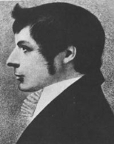
John Oxley
Encyclopedia

Australia
Australia , officially the Commonwealth of Australia, is a country in the Southern Hemisphere comprising the mainland of the Australian continent, the island of Tasmania, and numerous smaller islands in the Indian and Pacific Oceans. It is the world's sixth-largest country by total area...
in the early period of English colonisation.
October 1802 he was engaged in coastal survey work including an expedition to Western Port
Western Port
Western Port, is sometimes called "Western Port Bay", is a large tidal bay in southern Victoria, Australia opening into Bass Strait. It is the second largest bay in Victoria. Geographically, it is dominated by the two large islands; French Island and Phillip Island. Contrary to its name, it lies to...
in 1804-05. In 1805 Governor King appointed him acting lieutenant in charge of the Buffalo, and in 1806 he commanded the Estramina
Estramina
The Estramina , originally called Extremeña, a two masted schooner of 102 tons, was built at Guayaquil, in the Spanish Viceroyalty of Peru, now in modern day Ecuador, and launched on 13 October 1803. A Spanish Naval vessel, it was pierced for 12 guns but was armed with only four 4-pounders and...
on a trip to Van Diemen's Land. Next year he returned to England where, on 25 November, he was commissioned lieutenant. He came back to Sydney in November 1808 to take up an appointment as first lieutenant in , having sailed out as agent for the Transport Board
Transport Board
The Transport Board was the British Royal Navy organisation responsible for the transport of supplies and military. It is also referred to as the Board of Transport and Transport Office....
in the convict ship Speke, in which he shipped goods worth £800 as an investment. He had obtained an order from the Colonial Office for a grant of 600 acres (242.8 ha) near the Nepean River, but Lieutenant-Governor Paterson granted him 1000 acres (404.7 ha). Oxley had to surrender these in 1810, but Governor Macquarie granted him 600 acres (242.8 ha) near Camden
Camden, New South Wales
-Education:Camden is the location of research facilities for the veterinary and agricultural schools of the University of Sydney. The local government area has two public high schools, Camden High School and Elderslie High School, as well as eight Catholic and three Anglican schools.-Culture:The...
which he increased in 1815 to 1000 acres (404.7 ha) again. This he called Kirkham.
When Paterson allowed the deposed Governor Bligh to leave Sydney in Porpoise in March 1809 Oxley was aboard and sailed with Bligh to the Derwent. Next year he wrote a lengthy report on the settlements in Van Diemen's Land
Van Diemen's Land
Van Diemen's Land was the original name used by most Europeans for the island of Tasmania, now part of Australia. The Dutch explorer Abel Tasman was the first European to land on the shores of Tasmania...
before sailing for England in Porpoise in May. In London he applied for the post of Naval Officer in Sydney, and then, after paying C. Grimes to resign, according to John Macarthur
John Macarthur (wool pioneer)
John Macarthur was a British army officer, entrepreneur, politician, architect and pioneer of settlement in Australia. Macarthur is recognised as the pioneer of the wool industry that was to boom in Australia in the early 19th century and become a trademark of the nation...
, he twice sought that of surveyor-general. Oxley denied that he had been a partisan of Macarthur when Bligh was deposed, but his letters show that he was on very intimate terms with the rebel leader. In 1812 he became engaged to Elizabeth Macarthur; this was broken off when her father discovered the extent of Oxley's debts. By that time, through the influence of Macarthur's friend Walter Davidson, Oxley's second application for the surveyor-generalship had been successful. In 1811 he had retired from the navy, and in May 1812 sailed for Sydney in the Minstrel to take up his new duties.
Naval career
John Oxley entered the Royal NavyRoyal Navy
The Royal Navy is the naval warfare service branch of the British Armed Forces. Founded in the 16th century, it is the oldest service branch and is known as the Senior Service...
when he was aged eleven. He travelled to Africa
Africa
Africa is the world's second largest and second most populous continent, after Asia. At about 30.2 million km² including adjacent islands, it covers 6% of the Earth's total surface area and 20.4% of the total land area...
in October 1802 as master’s mate of the naval-vessel Boo, which carried out coastal surveying (including the survey of Western Port). In 1805 Oxley was promoted to second lieutenant. In 1806 he commanded the Estramina on a trip to Van Diemen's Land (now Tasmania
Tasmania
Tasmania is an Australian island and state. It is south of the continent, separated by Bass Strait. The state includes the island of Tasmania—the 26th largest island in the world—and the surrounding islands. The state has a population of 507,626 , of whom almost half reside in the greater Hobart...
). He returned to England in 1807 and was appointed first lieutenant of 'Porpoise, joining her in 1808. In 1809 Porpoise visited Van Diemen's Land, carrying as a passenger Governor William Bligh
William Bligh
Vice Admiral William Bligh FRS RN was an officer of the British Royal Navy and a colonial administrator. A notorious mutiny occurred during his command of HMAV Bounty in 1789; Bligh and his loyal men made a remarkable voyage to Timor, after being set adrift in the Bounty's launch by the mutineers...
who had been deposed in the Rum Rebellion
Rum Rebellion
The Rum Rebellion of 1808 was the only successful armed takeover of government in Australia's history. The Governor of New South Wales, William Bligh, was deposed by the New South Wales Corps under the command of Major George Johnston, working closely with John Macarthur, on 26 January 1808, 20...
.
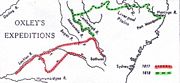
Lachlan River expedition
Lachlan River
- Course :The river rises in the central highland of New South Wales, part of the Great Dividing Range, 13 km east of Gunning. Its major headwaters, the Carcoar River, the Belubula River and the Abercrombie River converge near the town of Cowra. Minor tributaries include the Morongla Creek...
. He left Sydney on 6 April with George Evans
George Evans (explorer)
George William Evans was a surveyor and early explorer in the colony of New South Wales. Evans was born in Warwick, England, migrating to Australia in October 1802.-Early Career:...
as second-in-command, and Allan Cunningham as botanist. Evans had discovered a portion of the Lachlan River west of Bathurst
Bathurst, New South Wales
-CBD and suburbs:Bathurst's CBD is located on William, George, Howick, Russell, and Durham Streets. The CBD is approximately 25 hectares and surrounds two city blocks. Within this block layout is banking, government services, shopping centres, retail shops, a park* and monuments...
in 1815. Oxley’s party reached Bathurst after a week, where they were briefly detained by bad weather. They reached the Lachlan River on 25 April 1817 and commenced to follow its course, with part of the stores being conveyed in boats. As the exploring party travelled westward the country surrounding the rising river was found to be increasingly inundated. On 12 May, west of the present township of Forbes, they found their progress impeded by an extensive marsh. After retracing their route for a short distance they then proceeded in a south-westerly direction, intending to travel overland to the southern Australian coastline. By the end of May the party found themselves in a dry scrubby country. Shortage of water and the death of two horses forced Oxley’s return to the Lachlan River. On 23 June the Lachlan River was reached: “we suddenly came upon the banks of the river… which we had quitted nearly five weeks before”. They followed the course of the Lachlan River for a fortnight. The party encountered much flooded country, and on 7 July Oxley recorded that "it was with infinite regret and pain that I was forced to come to the conclusion, that the interior of this vast country is a marsh and uninhabitable". Oxley resolved to turn back and after resting for two days Oxley’s party began to retrace their steps along the Lachlan River. They left the Lachlan up-stream of the present site of Lake Cargelligo and crossed to the Bogan River
Bogan River
The Bogan River is an inland river in the central west of New South Wales, Australia.This river rises at Goonumbla, 19 kilometres north-west of Parkes and flows in a generally north-north-westerly direction past Tottenham, Peak Hill and through Nyngan. The Bogan River is about 590 km in length...
and then across to the upper waters of the Macquarie
Macquarie River
The Macquarie River is one of the main inland rivers in New South Wales. Its headwaters rise in the central highlands of New South Wales near the town of Oberon. The river travels generally northwest past the towns of Bathurst, Wellington, Dubbo, Narromine, and Warren to the Macquarie Marshes...
, which they followed back to Bathurst (arriving on 29 August 1817).
Macquarie River expedition
Oxley travelled to Dubbo on 12 June 1818. He wrote that he had passed that day 'over a very beautiful country, thinly wooded and apparently safe from the highest floods...'Later in 1818 Oxley and his men explored the Macquarie River at length before turning east. On 26 August 1818 they climbed a hill and saw before them rich, fertile land (Peel River), near the present site of Tamworth
Tamworth, New South Wales
Tamworth is a city in the New England region of New South Wales, Australia. Straddling the Peel River, Tamworth, which contains an estimated population of 47,595 people, is the major regional centre for southern New England and in the local government area of Tamworth Regional Council. The city...
. Continuing further east they crossed the Great Dividing Range
Great Dividing Range
The Great Dividing Range, or the Eastern Highlands, is Australia's most substantial mountain range and the third longest in the world. The range stretches more than 3,500 km from Dauan Island off the northeastern tip of Queensland, running the entire length of the eastern coastline through...
passing by the Apsley Falls
Apsley Falls
The Apsley Falls are two waterfalls on the Apsley River on the Northern Tablelands, New South Wales, Australia. The falls are located about east of Walcha, and 1 kilometre off the Oxley Highway in a deep gorge, that is part of the Oxley Wild Rivers National Park...
on 13 September 1818 which he named the Bathurst Falls. He described it as “one of the most magnificent waterfalls we have seen”. He discovered and named the Arbuthnot Range, since renamed the Warrumbungle Range.
Upon reaching the Hastings River
Hastings River
The Hastings River is a large river on the Mid North Coast of the Australian state of New South Wales that empties into the Tasman Sea, a branch of the South Pacific Ocean, at Port Macquarie....
they followed it to its mouth, discovering that it flowed into the sea at a spot which they named Port Macquarie
Port Macquarie, New South Wales
Port Macquarie is a city on the Mid North Coast of New South Wales, Australia, located about north of Sydney, and south of Brisbane. The city is located on the coast, at the mouth of the Hastings River, and has an estimated population of 44,313....
.
Oxley's 1823 expedition to Port Curtis and discovery of the Tweed River
As Surveyor General, John Oxley, made a close examination of the Tweed River and Port Curtis, and sources connected that investigation, principally the manuscript journal kept by Oxley, and the published ‘Narrative’ of John Uniaeke, who accompanied Oxley, From Oxley’s notebook in the Archives Office of New South Wales (location 2 /8093) the following extract is taken from the entry for 31 October 1823 :“Fri.31 Oct.
At 3[PM] made sail intending to anchor to the South of Point Danger. At 5[PM] passed close to a Bold Headland [present-day Point Danger]about 3 Miles North of Pt. D.[Cook's Point Danger - Fingal Head] On the South Side of this headland we had the satisfaction to discover a considerable river with an apparent clear entrance. Hove on for the purpose of anchoring between the Island and the Main land [Fingal Head]. At ½ past 5 passing too close to the Island we shoaled our “water to 2 ½ fms but almost instantly deepened to 5 fms. Anchored under the lee of the Island in 7 fms sandy Bottom being tolerably sheltered from the SSE round by the w to NE - the distance between the Island and the Main is about 50 chains, the point of the Main as well as the Island composed of regular Basaltic Pillars.
To the South extends a Sandy Beach of about 3 ½ miles ending in a low sandy Point off which brakers seem to extend about ¾ of a mile. Soundings between the Island and the Main and found the deepest water 6 fms in mid channel rather including to the Mainland.
Observed the River from the Mast head take a SW direction running through a moderately elevated country towards the Base of Mt. Warning.”
John Uniacke made the following relevant observations.
“Monday 27 October 1823: The wind being fair, we immediately got under way, and continued our course to the northward till Friday afternoon, when it shifted, and came on to blow so hard, that we determind to run in shore and look out for anchorage; this we found under the lee of a small island off Point Danger (so named by Captain Cook), about a mile from the land. While running down for this place, we perceived the mouth of a large river about a mile and a half to the northward; and next morning at daylight the master was dispatched in the whale-boat to ascertain the possibility of taking the vessel into it.
Shortly afterwards, Mr. Stirling and I landed on the island with our guns. The rocks which formed the base was evidently of volcanic origin: it was of dark colour, full of small holes and extremely hard, while on the western side many regular circular cavities, some of which were about four or five yards in diameter at top, and tapered down gradually towards the bottom, which was usually filled with round stones.
One of these holes, in particular, had a communication underneath with the sea, and at every returning surf threw up considerable quantities of water with a loud noise. The superincumbent rocks were basaltic, and those of a small rock to the N.W. of the island, as well as those of a bluff headland, immediately opposite on the main, were inferior only in extent to the Giant’s Causeway in the north of Ireland.”
(Field, Geographical Memoirs, p. 33-34)
John Uniack also noted:“ The little island under which we lay received the name of Turtle Island, in gratitude for the abundant supply of that fish which we procured from it. We also gave the name of “Tweed “ to the river. The latitude of our anchorage is 28° 8' S. and its longitude 153° 31' (Field Memoirs, p. 40-41)
Captain Phillip Parker King had previously surveyed that portion of the coast in the proximity of Point Danger, although adverse weather conditions prevented his examining that portion too closely. His observations, as recorded on 22 and 23 May 1819, and published in his Narrative of a Survey of Intertropical and Western Coast of Australia Performed between the years 1818 and 1822.
(Lond. , Murry, 1827) , Vol. 1, p. 178-179, are as follows:-
“22. The next evening, Mount Warning was seen from the deck, although we were at least seventy-eight miles from it. 23 On the 23d at noon, our latitude was 28°9' when the Mount bore S 58° W (Magnetic).
At sunset the wind died away; and, from the land in the vicinity of the mountain indicating every appearance of the existence of either a large sheet of water or a poening of consequence, I was induced to remain two days to examine the beach more narrowly; but, after beating about with a strong south-easterly current which prevented my tracing the beach to the northward of the Mount, and having only seen an inconsiderable opening that communicates by a shoal channel with a small lagoon at the back of the beach,
I gave up the search; still without satisfying myself of the non-existence of an inlet, which, if there be one, probably communicates with the sea nearer to Point Danger.
Lieut Oxley has since (1823) discovered this to be the case, for he found a stream empting itself into the sea, by a bar harbour close to Point Danger. Lieutenant Oxley called it the Tweed. ”
In the Appendix to vol .2 of that work, containing a description of the ports, Islands and Coast between Port Jackson and Breakesea Spit, the following description of the Tweed River confirms that Captain King clearly considered Point Danger to be the southernmost of the two points :-
“ The Tweed is a river communicating with the sea by a bar, on which there is twelve feet of water, it is situated about a mile and a half to the north of a small island off Point Danger, which lies in latitude 28° 8' ”
(King Narrative of a Survey, v. 2, p. 257)
Captain Henry Rous further examined the Tweed River in 1828, and Incorrectly identify the present-day Point Danger, as the Point Danger of James Cook and recorded the name ‘Cook’s Island’ rather than ‘ Turtle Island ’of Oxley. The following extract is from Captain Rous’ Description of the River Clarance and published in Wilton’s Australian Quartly Journal for 1828, p. 352 - 355 [Rous named Oxley's Tweed the Clarance River]
“ The River Clarance, or more properly the Tweed, discovered by Mr. Oxley, but not explored, is in lat. 28° 9', long. 153° 34' bearing N.W.½ W. from Turtle Island distant 2 ½ miles - it is situated to the southward of a Bluff Head, connected with the Main by a flat sandy Isthmus, 250 yards wide from high water mark forming a boundary to the river on one side, and to capacious bay to the northward - affording good anchorage and shelter from East Southerly to North….There is a small river about 10 miles NW by W from the *north bluff of Point Danger inaccessible for boats.”
Oxley sailed northwards from the Tweed Area in the Mermaid to explore Port Curtis (the site of Gladstone
Gladstone, Queensland
- Education :Gladstone has several primary schools, three high schools, and one university campus, Central Queensland University. It is also home to CQIT Gladstone Campus.- Recreation :...
) and Moreton Bay
Moreton Bay
Moreton Bay is a bay on the eastern coast of Australia 45 km from Brisbane, Queensland. It is one of Queensland's most important coastal resources...
. He continued to explore the region, which is now known as South East Queensland
South East Queensland
South East Queensland is a region of the state of Queensland in Australia, which contains approximately two-thirds of the state population...
.
In 1824 Oxley, accompanied by Allan Cunningham
Allan Cunningham (botanist)
Allan Cunningham was an English botanist and explorer, primarily known for his travels in New South Wales to collect plants.- Early life :...
, discovered the Brisbane River
Brisbane River
The Brisbane River is the longest river in south east Queensland, Australia, and flows through the city of Brisbane, before emptying into Moreton Bay. John Oxley was the first European to explore the river who named it after the Governor of New South Wales, Thomas Brisbane in 1823...
and Bremer River on Moreton Bay, which has since developed into the city of Brisbane
Brisbane
Brisbane is the capital and most populous city in the Australian state of Queensland and the third most populous city in Australia. Brisbane's metropolitan area has a population of over 2 million, and the South East Queensland urban conurbation, centred around Brisbane, encompasses a population of...
.
Governor Lachlan Macquarie
Lachlan Macquarie
Major-General Lachlan Macquarie CB , was a British military officer and colonial administrator. He served as the last autocratic Governor of New South Wales, Australia from 1810 to 1821 and had a leading role in the social, economic and architectural development of the colony...
granted him 600 acres (242.8 ha) near Camden in 1810, which he increased to 1000 acres (404.7 ha) in 1815. He named this property Kirkham and raised and bred sheep. He was also briefly a director of the Bank of New South Wales. He was one of five members of the original New South Wales Legislative Council
New South Wales Legislative Council
The New South Wales Legislative Council, or upper house, is one of the two chambers of the parliament of New South Wales in Australia. The other is the Legislative Assembly. Both sit at Parliament House in the state capital, Sydney. The Assembly is referred to as the lower house and the Council as...
in 1824, but was not reappointed when the council was reconstituted in 1825.
Marriage and children
In August 1822, Oxley married Emma Norton (1798–1885), the youngest sister of James NortonJames Norton (colonial New South Wales figure)
James Norton was a solicitor and public figure in early colonial New South Wales. Admitted to practise in England, he arrived in Sydney in September 1818 where only four other attorneys were then practising. He was the founder of the first law firm in Sydney...
who had followed he brother out to New South Wales from Sussex after he had established himself as an attorney in the colony. They had two sons. The elder, John Norton Oxley (1824 - 1891), became the representative of the Western Camden electorate in the first Parliament after the establishment of responsible government in 1856. He sponsored the Broad Gauge Act which encouraged the use of waggons with broad wheels instead of narrow-tired drays in order to cause less wear on public roads; this measure made him unpopular with the farmers and carriers in his electorate and he lost his seat. The younger son was Henry Molesworth Oxley (1826 - 1867) who was Member of the Legislative Assembly for Camden (28 Jun 185910 Nov 1860).
Oxley also had two daughters out of wedlock before his marriage: one with Charlotte Thorpe and another with Elizabeth Marnon.
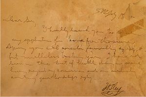
Illness and Death
Honours
The Oxley HighwayOxley Highway
The Oxley Highway is a rural highway in New South Wales, Australia. It starts at Nevertire where it joins the Mitchell Highway. It links Warren, Gilgandra, Coonabarabran, Gunnedah, Carroll, Tamworth, Bendemeer, Walcha, Yarrowitch, Ellenborough, Long Flat, Wauchope and ends at Port Macquarie on the...
in New South Wales
New South Wales
New South Wales is a state of :Australia, located in the east of the country. It is bordered by Queensland, Victoria and South Australia to the north, south and west respectively. To the east, the state is bordered by the Tasman Sea, which forms part of the Pacific Ocean. New South Wales...
, the township of Oxley, New South Wales
Oxley, New South Wales
Oxley is a community on the lower Lachlan River in the Riverina district of New South Wales, Australia. It is located near the junction of the Lachlan and Murrumbidgee rivers. The township which developed in the mid 1860s was named after the noted Australian explorer, John Oxley...
, the suburb of Oxley Park, New South Wales
Oxley Park, New South Wales
Oxley Park is a suburb of Sydney, in the state of New South Wales, Australia. It is located on the easternmost side of the City of Penrith Local Government Area...
, Oxley Island on the north coast of New South Wales, the Federal electorate of Oxley
Division of Oxley
The Division of Oxley is an Australian Electoral Division in Queensland. The current division is the second to bear the name, and was created in 1949. The division is named after the Australian explorer, John Oxley...
(Queensland), the New South Wales electorate of Oxley, the former Queensland electorate of Oxley, the Oxley Wild Rivers National Park
Oxley Wild Rivers National Park
Oxley Wild Rivers National Park is in New South Wales, Australia, 445 kilometres north of Sydney and is named in memory of the Australian explorer John Oxley, who passed through the area in 1818...
, Oxley Creek (Queensland) and the suburbs of Oxley, Queensland
Oxley, Queensland
Oxley is a south-western suburb of Brisbane located approximately 11 km from the Brisbane CBD. It was named after the early Australian explorer John Oxley. The suburb supports a mix of residential, retail and industrial land use....
and Oxley, Australian Capital Territory
Oxley, Australian Capital Territory
Oxley is the smallest suburb in Canberra. It is located in the district of Tuggeranong. The suburb is named after the explorer John Joseph William Molesworth Oxley , who explored parts of New South Wales. It was gazetted on 22 March 1982 and first settled in 1985...
are named after Oxley as was the former John Oxley Memorial Hospital (now demolished), in Wacol, Queensland
Queensland
Queensland is a state of Australia, occupying the north-eastern section of the mainland continent. It is bordered by the Northern Territory, South Australia and New South Wales to the west, south-west and south respectively. To the east, Queensland is bordered by the Coral Sea and Pacific Ocean...
. The John Oxley Library, part of the State Library of Queensland
State Library of Queensland
The State Library of Queensland is a large public library provided to the people of the State of Queensland, Australia, by the state government. Its legislative basis is provided by the Queensland Libraries Act 1988...
, is dedicated to preserving and making available Queensland's documentary history.
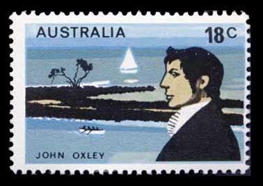
In 1976 he was honoured on a postage stamp
Postage stamp
A postage stamp is a small piece of paper that is purchased and displayed on an item of mail as evidence of payment of postage. Typically, stamps are made from special paper, with a national designation and denomination on the face, and a gum adhesive on the reverse side...
bearing his portrait issued by Australia Post
Australia Post
Australia Post is the trading name of the Australian Government-owned Australian Postal Corporation .-History:...
http://www.australianstamp.com/images/large/0011590.jpg.
John Oxley was born in Farnsfield
Farnsfield
Farnsfield is a village and civil parish in Nottinghamshire in Sherwood Forest. It is in the local government district of Newark and Sherwood....
, Nottinghamshire
Nottinghamshire
Nottinghamshire is a county in the East Midlands of England, bordering South Yorkshire to the north-west, Lincolnshire to the east, Leicestershire to the south, and Derbyshire to the west...
, UK. Oxley Close was named after the explorer to honour his exploits in the new world.
Further reading
Johnson, Richard, The Search for the Inland Sea: John Oxley, Explorer, 1783-1828, Melbourne University Press, 2001.External links
- Journals of Two Expeditions into the Interior of New South Wales, undertaken by order of the British government in the years 1817-18
- Australian Dictionary of Biography Online
- The Allan Cunningham Project, Allan Cunningham, botanist explorer 1791-1839, accompanied John Oxley on his journey along the Lachlan River in 1817
- John Oxley Library, a part of the State Library of Queensland