

Bicentennial National Trail
Encyclopedia
Trail
A trail is a path with a rough beaten or dirt/stone surface used for travel. Trails may be for use only by walkers and in some places are the main access route to remote settlements...
in the world, stretching 5,330 kilometres from Cooktown
Cooktown, Queensland
Cooktown is a small town located at the mouth of the Endeavour River, on Cape York Peninsula in Far North Queensland where James Cook beached his ship, the Endeavour, for repairs in 1770. At the 2006 census, Cooktown had a population of 1,336...
, through New South Wales
New South Wales
New South Wales is a state of :Australia, located in the east of the country. It is bordered by Queensland, Victoria and South Australia to the north, south and west respectively. To the east, the state is bordered by the Tasman Sea, which forms part of the Pacific Ocean. New South Wales...
to Healesville
Healesville, Victoria
Healesville is a town in Victoria, Australia, 52 km north-east from Melbourne's central business district. Its Local Government Area is the Shire of Yarra Ranges...
, 60 km north-east of Melbourne
Melbourne
Melbourne is the capital and most populous city in the state of Victoria, and the second most populous city in Australia. The Melbourne City Centre is the hub of the greater metropolitan area and the Census statistical division—of which "Melbourne" is the common name. As of June 2009, the greater...
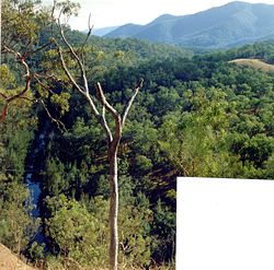
. This trail runs the length of the rugged Great Dividing Range
Great Dividing Range
The Great Dividing Range, or the Eastern Highlands, is Australia's most substantial mountain range and the third longest in the world. The range stretches more than 3,500 km from Dauan Island off the northeastern tip of Queensland, running the entire length of the eastern coastline through...
through national park
National park
A national park is a reserve of natural, semi-natural, or developed land that a sovereign state declares or owns. Although individual nations designate their own national parks differently A national park is a reserve of natural, semi-natural, or developed land that a sovereign state declares or...
s, private property and alongside of wilderness areas. The BNT trail follows old coach roads, stock route
Stock route
In Australia, the Travelling Stock Route is an authorised thoroughfare for the walking of domestic livestock such as sheep or cattle from one location to another...
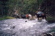
s, brumby tracks, rivers and fire trails. It was originally intended for horses, but is these days promoted also for cycling and walking. However is not yet entirely suited to these two activities.
History
The trail was initiated and planned by the Australian Trail Horse Riders Association. The association spent many years planning and negotiating a route that linked up the mustering, brumbyBrumby
A Brumby is a free-roaming feral horse in Australia. Although found in many areas around the country, the best-known brumbies are found in the Australian Alps region in south-eastern Australia. Today, most of them are found in the Northern Territory, with the second largest population in Queensland...
tracks, pack horse trails, historic coach
Coach (carriage)
A coach was originally a large, usually closed, four-wheeled carriage with two or more horses harnessed as a team, controlled by a coachman and/or one or more postilions. It had doors in the sides, with generally a front and a back seat inside and, for the driver, a small, usually elevated seat in...
roads and stock routes, thus providing an opportunity to legally ride the routes of stockmen and drovers
Drover (Australian)
A drover in Australia is a person, typically an experienced stockman, who moves livestock, usually sheep or cattle, "on the hoof" over long distances. Reasons for droving may include: delivering animals to a new owner's property, taking animals to market, or moving animals during a drought in...
who once travelled these areas.
R. M. Williams
Reginald Murray Williams AO, CMG was an Australian bushman and entrepreneur who rose from a swagman, to a millionaire. Widely known as just 'R.M.', he was born at Belalie North near Jamestown in the Mid North, 200 kilometres north of Adelaide, into a pioneering settler family working and training...
. Dan Seymour was sponsored by R.M. Williams to find a route along the Great Dividing Range
Great Dividing Range
The Great Dividing Range, or the Eastern Highlands, is Australia's most substantial mountain range and the third longest in the world. The range stretches more than 3,500 km from Dauan Island off the northeastern tip of Queensland, running the entire length of the eastern coastline through...
, and to promote enthusiasm for the proposal. Dan volunteered to ride the Trail and set off from Ferntree Gully, Victoria
Ferntree Gully, Victoria
Ferntree Gully is a suburb in Melbourne, Victoria, Australia, in the Dandenong Ranges, 29 km east from Melbourne's central business district. It is in the Local Government Area's of the Shire of Yarra Ranges and the City of Knox...
in February 1972 with two saddle horses, a packhorse
Packhorse
.A packhorse or pack horse refers generally to an equid such as a horse, mule, donkey or pony used for carrying goods on their backs, usually carried in sidebags or panniers. Typically packhorses are used to cross difficult terrain, where the absence of roads prevents the use of wheeled vehicles. ...
and ‘Bluey’ his blue heeler cattle dog. The Australian Trail Horse Riders Association provided Dan with encouragement during this lengthy journey. His amazing twenty-one month ride finished in Cooktown, Queensland
Cooktown, Queensland
Cooktown is a small town located at the mouth of the Endeavour River, on Cape York Peninsula in Far North Queensland where James Cook beached his ship, the Endeavour, for repairs in 1770. At the 2006 census, Cooktown had a population of 1,336...
in September 1973. Dan’s journey, which was regularly reported, created increased interest in the formation of the Trail.
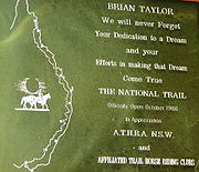
The development of this image was left to a committee led by R. M. Williams and coordinated and planned by Brian Taylor http://www.aswagofmemories.com/aboutauthor/trail in cooperation with the Australian Trail Horse Riders Association affiliated clubs, farmers, landowners and government agencies.
The Trail committee proposed that the concept be made a project to celebrate Australia’s Bicentenary
Australian Bicentenary
The bicentenary of Australia was celebrated in 1970 on the 200th anniversary of Captain James Cook landing and claiming the land, and again in 1988 to celebrate 200 years of permanent European settlement.-1970:...
in 1988. The suggestion was accepted, and funding of $300,000 was available to research, mark a route and print guidebooks. In November 1988, this had been accomplished and the Bicentennial National Trail was opened.
The office in Toowoomba
Toowoomba, Queensland
Toowoomba is a city in Southern Queensland, Australia. It is located west of Queensland's capital city, Brisbane. With an estimated district population of 128,600, Toowoomba is Australia's second largest inland city and its largest non-capital inland city...
has now closed and the Bicentennial National Trail is run from a mobile office, currently in Oberon, New South Wales
Oberon, New South Wales
-See also:*Oberon Correctional Centre*Mount Trickett*Mount Bindo*Shooters Hill-External links:***...
. Since the opening of the trail people have travelled all or a part of the trail with camel
Camel
A camel is an even-toed ungulate within the genus Camelus, bearing distinctive fatty deposits known as humps on its back. There are two species of camels: the dromedary or Arabian camel has a single hump, and the bactrian has two humps. Dromedaries are native to the dry desert areas of West Asia,...
s and donkey
Donkey
The donkey or ass, Equus africanus asinus, is a domesticated member of the Equidae or horse family. The wild ancestor of the donkey is the African Wild Ass, E...
s as well as with horses and mountain bikes.
Bicentennial National Trail Riders
From Cooktown to Healesville 5330 km &
From Healesville to Cooktown 5330 km
1989
- Ken Roberts and Sharon Muir Watson (south with Horses Cooktown to Healesville)The first horse riders North to South.
1991
- Arlene Christopherson, (north with horses Healesville to Cooktown) The first horse rider South to North.
- Anthony Mair and Melissa Weeks, (heading north with horses from Healsville to Cooktowwn)
1994
- Gabrielle Schenk (south with horses Cooktown to Healesville)
1995
- Darryl(Doc) Eckley and Robyn Surry Healesville to Cooktown
1997
- Peter Spotswood (Cooktown To Healesville with horses)
1999
- Geoff Daniel (Healesville to Cooktown with horses)
- Ed and Maria Van Zelderen. ( Cooktown to Healsevllle to Cooktown with horses 10000 km) The first Riders both directions.
2000
- Urs Marquardt and Karin Heitzmann, (Cooktown to Healesville on Horses)
- Dyane Sabourin and Geoft Grundy with daughter Angela and Serena Cooktown to Healesville with horses)
2003
- Therese Hanna ( Healesville To Cooktown with horses)
The Trail
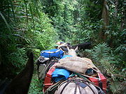
The Bicentennial National Trail is suitable for self-reliant horse riders, walkers and mountain bike riders. Parts of the Trail, such as some of the Jenolan Caves
Jenolan Caves
The Jenolan Caves are caves in the Blue Mountains, New South Wales, Australia; 175 kilometres west of Sydney. They are the most celebrated of several similar groups in the limestone of the country being the oldest discovered open caves in the world...
to Kosciuszko section, are suitable for horse drawn vehicles. Most of the trail route is not open to motorised vehicles or trail bikes, and pets or dogs are not permitted.
The trail is divided into 12 sections, of 400 to 500 kilometres, each with a corresponding guide book.
1. Cooktown
Cooktown, Queensland
Cooktown is a small town located at the mouth of the Endeavour River, on Cape York Peninsula in Far North Queensland where James Cook beached his ship, the Endeavour, for repairs in 1770. At the 2006 census, Cooktown had a population of 1,336...
to Gunnawarra; the trail passes through rain forest, gold fields and historical tin mining towns.
2. Gunnawarra to Collinsville, through the grazing country of far north Queensland.
3. Collinsville
Collinsville, Queensland
Collinsville is a mining town in the coal-rich Bowen Basin region of central Queensland, Australia, 1245 km north of Brisbane and 87 km south-west of the coastal town of Bowen. The town is part of the Whitsunday Region...
to Kabra
4. Kabra to Biggenden
5. Biggenden
Biggenden, Queensland
Biggenden is a town situated on the Isis Highway in southern Queensland, Australia, 339 km north-west of the state capital Brisbane, and 84 km west of Maryborough. At the 2006 census, Biggenden had a population of 644....
to Blackbutt
6. Blackbutt, Queensland
Blackbutt, Queensland
Blackbutt is a town in the South Burnett region of Queensland, Australia. The town is located on the D'Aguilar Highway, in the South Burnett Local Government Area, 166 kilometres north west of the state capital, Brisbane. At the 2006 census, Blackbutt had a population of 572.European settlement...
to the New South Wales border at Cullendore
7. Killarney
Killarney, Queensland
Killarney is a small town located 35 km south-east of Warwick, on the Condamine River in Queensland, Australia. The town forms part of the Southern Downs local government area. Killarney is located about 8 km from the Queensland/New South Wales border. It is close to Queen Mary Falls, in the Main...
to Ebor
Ebor, New South Wales
Ebor is a village on Waterfall Way on the Northern Tablelands, New South Wales, Australia. It is situated about east of Armidale and about a third of the way between Armidale and the coast. At the 2006 census, Ebor and the surrounding area had a population of 160...
; this is a rugged remote section that follows the Guy Fawkes River
Guy Fawkes River
The Guy Fawkes River is a river in northern New South Wales, Australia that runs from the south to north along the valley of the Demon Fault Line in the Guy Fawkes River National Park....
through Guy Fawkes River National Park
Guy Fawkes River National Park
Guy Fawkes River National Park is on Waterfall Way near Ebor, New South Wales, 50 kilometres west of Dorrigo and 80 km north-east of Armidale in Australia...
and across Waterfall Way
Waterfall Way
The Waterfall Way is a road and State Highway 78 in New South Wales, Australia. It runs east-west from the Pacific Highway to the New England Highway at Armidale. The route passes through some of New South Wales' most scenic countryside and has become well known as New South Wales best and...
.
8. Ebor to Barrington Tops, is another rugged remote section that passes through Oxley Wild Rivers National Park
Oxley Wild Rivers National Park
Oxley Wild Rivers National Park is in New South Wales, Australia, 445 kilometres north of Sydney and is named in memory of the Australian explorer John Oxley, who passed through the area in 1818...
. After passing Ebor the trail crosses the Point Lookout
Point Lookout, New South Wales
Point Lookout is the name of a mountain in the New England National Park, near Ebor, Australia.It is the second highest peak in the Snowy Range, a spur of the Great Dividing Range which forms the highest part, and eastern edge of the Northern Tablelands...
Road before it passes briefly through Cunnawarra National Park
Cunnawarra National Park
Cunnawarra is a national park in New South Wales, Australia, 80 km east of Armidale, 10 km off the Waterfall Way and 565 km north of Sydney. The 25 kilometre Styx River Forest Way runs from the Point Lookout Road through Cunnawarra National Park to the Kempsey Road...
. It then runs on the east of Georges River until it crosses the Armidale to Kempsey road. The track is mostly unmarked as it follows the Macleay River
Macleay River
The Macleay River is a major river on the Mid North Coast , Australia.The headwaters of the Macleay River rise as the Gara River on the eastern side of the Northern Tablelands near Armidale and Walcha, New South Wales. From here the Chandler River, Styx River and Apsley Rivers are important...
past the historic East Kunderang homestead
Homestead (buildings)
A homestead is either a single building, or collection of buildings grouped together on a large agricultural holding, such as a ranch, station or a large agricultural operation of some other designation.-See also:* Farm house* Homestead Act...
in Oxley Wild Rivers National Park. Following Kunderang Brook it winds its way to mustering huts at Left Hand Hut, the remote Middle Yards Hut, Youdale’s Hut and to Cedar Creek on the edge of Werrikimbe National Park
Werrikimbe National Park
Werrikimbe National Park is in the catchment zone of the Upper Hastings River, New South Wales, Australia, about 486 km north of Sydney. This national park is about 80 km west of Wauchope and 90 km east of Walcha on the eastern escarpment of the Great Dividing Range...
. After crossing the Oxley Highway
Oxley Highway
The Oxley Highway is a rural highway in New South Wales, Australia. It starts at Nevertire where it joins the Mitchell Highway. It links Warren, Gilgandra, Coonabarabran, Gunnedah, Carroll, Tamworth, Bendemeer, Walcha, Yarrowitch, Ellenborough, Long Flat, Wauchope and ends at Port Macquarie on the...
the trail passes through the Mummel Gulf National Park
Mummel Gulf National Park
Mummel Gulf is a national park in New South Wales , about 487 kilometres by road north of Sydney. It is situated approximately 50 km southeast of Walcha on the unsealed Enfield Forest Road and 12 km south of the Oxley Highway....
. This section takes at least five days to travel and all food and equipment has to be carried. There are numerous creek and river crossings, with some steep ascents and descents.
9. Barrington Tops to Jenolan Caves
10. Jenolan Caves to Kosciuszko
12. Omeo
Omeo, Victoria
Omeo is a town in Victoria, Australia, located on the Great Alpine Road, east of Mount Hotham, in the Shire of East Gippsland. At the 2006 census, Omeo had a population of 452. The name is derived from the Aboriginal word for 'mountains' or 'hills'...
to Healesville
Healesville, Victoria
Healesville is a town in Victoria, Australia, 52 km north-east from Melbourne's central business district. Its Local Government Area is the Shire of Yarra Ranges...
, near Melbourne