
Overland Trail
Encyclopedia
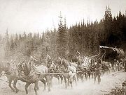
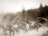
Stagecoach
A stagecoach is a type of covered wagon for passengers and goods, strongly sprung and drawn by four horses, usually four-in-hand. Widely used before the introduction of railway transport, it made regular trips between stages or stations, which were places of rest provided for stagecoach travelers...
and wagon trail in the American West during the 19th century. While portions of the route had been used by explorers and trappers since the 1820s, the Overland Trail was most heavily used in the 1860s as an alternative route to the Oregon
Oregon Trail
The Oregon Trail is a historic east-west wagon route that connected the Missouri River to valleys in Oregon and locations in between.After 1840 steam-powered riverboats and steamboats traversing up and down the Ohio, Mississippi and Missouri rivers sped settlement and development in the flat...
, California
California Trail
The California Trail was an emigrant trail of about across the western half of the North American continent from Missouri River towns to what is now the state of California...
and Mormon
Mormon Trail
The Mormon Trail or Mormon Pioneer Trail is the 1,300 mile route that members of The Church of Jesus Christ of Latter-day Saints traveled from 1846 to 1868...
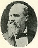
trails through central Wyoming. The Overland Trail was famously used by the Overland Stage Company owned by Ben Holladay
Ben Holladay
Benjamin "Ben" Holladay was an American transportation businessman known as the "Stagecoach King" until his routes were taken over by Wells Fargo in 1866...
to run mail and passengers to Salt Lake City, Utah
Salt Lake City, Utah
Salt Lake City is the capital and the most populous city of the U.S. state of Utah. The name of the city is often shortened to Salt Lake or SLC. With a population of 186,440 as of the 2010 Census, the city lies in the Salt Lake City metropolitan area, which has a total population of 1,124,197...
via stagecoaches in the early 1860s. Starting from Atchison, Kansas
Atchison, Kansas
Atchison is a city situated along the Missouri River in the eastern part of Atchison County, located in northeast Kansas, in the Central United States. As of the 2010 census, the city population was 11,021. It is the county seat and most populous city of Atchison County...
the trail descended into Colorado
Colorado
Colorado is a U.S. state that encompasses much of the Rocky Mountains as well as the northeastern portion of the Colorado Plateau and the western edge of the Great Plains...
before looping back up to southern Wyoming
Wyoming
Wyoming is a state in the mountain region of the Western United States. The western two thirds of the state is covered mostly with the mountain ranges and rangelands in the foothills of the Eastern Rocky Mountains, while the eastern third of the state is high elevation prairie known as the High...
and rejoining the Oregon Trail at Fort Bridger
Fort Bridger
Fort Bridger was originally a 19th century fur trading outpost established in 1842 on Blacks Fork of the Green River and later a vital resupply point for wagon trains on the Oregon Trail, California Trail and Mormon Trail. The Army established a military post here in 1858 during the Utah War until...
. The stage line operated until 1869 when the completion of the First Transcontinental Railroad
First Transcontinental Railroad
The First Transcontinental Railroad was a railroad line built in the United States of America between 1863 and 1869 by the Central Pacific Railroad of California and the Union Pacific Railroad that connected its statutory Eastern terminus at Council Bluffs, Iowa/Omaha, Nebraska The First...
eliminated the need for mail service via stagecoach.
History
Independence, Missouri
Independence is the fourth largest city in the U.S. state of Missouri, and is contained within the counties of Jackson and Clay. It is part of the Kansas City Metropolitan Area...
and Salt Lake City, Utah was established as early as 1850. The mail was delivered by rail to Independence and then brought to Salt Lake City via the Oregon and Mormon Trail
Mormon Trail
The Mormon Trail or Mormon Pioneer Trail is the 1,300 mile route that members of The Church of Jesus Christ of Latter-day Saints traveled from 1846 to 1868...
on wagons. In 1851, George Chorpenning
George Chorpenning
George W. Chorpenning Jr. was a pioneer in the transportation of mail, freight, and passengers through the arid and undeveloped western regions of the United States...
and Abolam Woodward were awarded a contract for mail service between Salt Lake and Sacramento, California
Sacramento, California
Sacramento is the capital city of the U.S. state of California and the county seat of Sacramento County. It is located at the confluence of the Sacramento River and the American River in the northern portion of California's expansive Central Valley. With a population of 466,488 at the 2010 census,...
at first using the California Trail
California Trail
The California Trail was an emigrant trail of about across the western half of the North American continent from Missouri River towns to what is now the state of California...
but then later moving to the Central Nevada Route in 1860.
In 1857, the United States Postal Department extended bids for mail service along what became known as the "southern route
Butterfield Overland Mail
The Butterfield Overland Mail Trail was a stagecoach route in the United States, operating from 1857 to 1861. It was a conduit for the U.S. mail from two eastern termini, Memphis, Tennessee and St. Louis, Missouri, meeting Fort Smith, Arkansas, and continuing through Indian Territory, New Mexico,...
" from Memphis, Tennessee
Memphis, Tennessee
Memphis is a city in the southwestern corner of the U.S. state of Tennessee, and the county seat of Shelby County. The city is located on the 4th Chickasaw Bluff, south of the confluence of the Wolf and Mississippi rivers....
to San Francisco, California
San Francisco, California
San Francisco , officially the City and County of San Francisco, is the financial, cultural, and transportation center of the San Francisco Bay Area, a region of 7.15 million people which includes San Jose and Oakland...
through New Mexico
New Mexico
New Mexico is a state located in the southwest and western regions of the United States. New Mexico is also usually considered one of the Mountain States. With a population density of 16 per square mile, New Mexico is the sixth-most sparsely inhabited U.S...
and Arizona
Arizona
Arizona ; is a state located in the southwestern region of the United States. It is also part of the western United States and the mountain west. The capital and largest city is Phoenix...
. The contract was given to the Butterfield Overland Mail Company and service ran until the Civil War started in 1861. Wells Fargo
History of Wells Fargo
This article outlines the history of Wells Fargo & Company from its origins to its merger with Norwest and beyond. The new company chose to retain the name of "Wells Fargo" and so this article also includes the history after the merger.-Origins:...
was the primary lender to the company and took control when it suffered financial difficulties in 1859. After the southern route was disbanded the Overland Mail Company moved operations to the central line between Salt Lake City and Sacramento.
The Chorpenning contract was annulled in 1860 and was subsequently awarded to the Central Overland California and Pikes Peak Express Company
Central Overland California and Pikes Peak Express Company
The Central Overland California and Pike's Peak Express Company was the parent company of the Pony Express.It was formed by William Russell, Alexander Majors and William Waddell, as a freighting company supplying goods to the western United States...
which ran stage lines between Missouri and Utah along the Oregon Trail. In 1860 the C. O. C. & P. P. Express started the Pony Express
Pony Express
The Pony Express was a fast mail service crossing the Great Plains, the Rocky Mountains, and the High Sierra from St. Joseph, Missouri, to Sacramento, California, from April 3, 1860 to October 1861...
which followed the Oregon and Mormon Trails to Salt Lake City and the Central Nevada Route to Sacramento. The Pony Express only lasted a year before the C.O.C & P.P Express went bankrupt and the assets were sold to Ben Holladay. In 1861, Holladay was awarded the Postal Department contract for overland mail service between the end of the western terminus of the railroad in Missouri and Kansas and Salt Lake City. Service from Utah to California was given to the Overland Mail Company and other stage lines.
The start of the Civil War also forced the U.S. Army to move its regular soldiers from forts and outposts along the Oregon Trail to the east and replace them with volunteers. As a result, Native American raids on the trail intensified. The U.S Army and Holladay wanted to find a safer route to the south. In 1851 U.S. Army Topographical Engineer Captain Howard Stansbury
Howard Stansbury
Howard Stansbury was a major in the U.S. Army Corps of Topographical Engineers. His most notable achievement was leading a two-year expedition to survey the Great Salt Lake and its surroundings...
returning east from an expedition to the Salt Lake Valley described a route from Fort Bridger via the Bitter Creek valley and Laramie Plains to the North Platte River. Stansbury's route was well known by local trappers and traders. General William Henry Ashley
William Henry Ashley
William Henry Ashley was a pioneering fur trader, entrepreneur, and politician. Though a native of Virginia, Ashley had already moved to St. Genevieve in what was then called Louisiana, when it was purchased by the United States from France in 1803...
had crossed the Laramie Plains in 1825, John C. Fremont
John C. Frémont
John Charles Frémont , was an American military officer, explorer, and the first candidate of the anti-slavery Republican Party for the office of President of the United States. During the 1840s, that era's penny press accorded Frémont the sobriquet The Pathfinder...
camped near Elk Mountain
Elk Mountain (Carbon County, Wyoming)
Elk Mountain is a northern most of the Medicine Bow Mountains. It is southwest of the town of Elk Mountain, Wyoming and roughly from Rawlins, Wyoming. The mountain is the area's most visible feature. It is located south of Interstate 80 in Carbon County. Elk Mountain is the 8th most prominent...
in 1843 and miners and trappers heading to California used the Cherokee Trail
Cherokee Trail
The Cherokee Trail was a historic overland trail through the present-day U.S. states of Oklahoma, Kansas, Colorado, and Wyoming that was used from the late 1840s up through the early 1890s. The route was established in 1849 by a wagon train headed to the gold fields in California...
in the late 1840s. Based on these reports the new trail was established from Atchison, Kansas ascending the South Platte River
South Platte River
The South Platte River is one of the two principal tributaries of the Platte River and itself a major river of the American Midwest and the American Southwest/Mountain West, located in the U.S. states of Colorado and Nebraska...
and striking the Cherokee Trail though Wyoming to Fort Bridger. Mail service started along the Overland Stage Route on July 1, 1861. Holladay retained the mail contract on the route until 1866 when it was sold to Wells Fargo. Stage operations continued until 1869 when the completion of the Transcontinental Railroad made stage service unnecessary.
Over time, increasing emigrant traffic and homesteading in the plains and shifting buffalo herds forced Native American tribes into southern Wyoming and Northern Colorado leading to conflicts on the Overland Trail, especially in the eastern portion along the South Platte River and in the western portion along the Laramie Plains
Laramie Plains
The Laramie Plains is an arid highland in south central Wyoming in the United States. The plains extend along the upper basin of the Laramie River on the east side of the Medicine Bow Range. The city of Laramie is the largest community in the valley...
. Attempts to force the Indians to a reservation came to a head during the Colorado War
Colorado War
The Colorado War was fought from 1863 to 1865 and was an Indian War between the Cheyenne and Arapaho tribes, against white settlers and militia in the Colorado Territory and adjacent regions...
in 1864. Camp Collins
Camp Collins
Camp Collins was a 19th century outpost of the United States Army in the Colorado Territory. The fort was commissioned in the summer of 1862 to protect the Overland Trail from attacks by Native Americans in a conflict that later became known as the Colorado War...
near present day Fort Collins, Colorado
Fort Collins, Colorado
Fort Collins is a Home Rule Municipality situated on the Cache La Poudre River along the Colorado Front Range, and is the county seat and most populous city of Larimer County, Colorado, United States. Fort Collins is located north of the Colorado State Capitol in Denver. With a 2010 census...
and Fort Sanders
Fort Sanders (Wyoming)
Fort Sanders was a wooden fort constructed in 1866 on the Laramie Plains in southern Wyoming, near the city of Laramie. Originally named Fort John Buford, it was renamed Fort Sanders after General William P. Sanders who died at the Siege of Knoxville during the American Civil War. This was the...
and Fort Halleck
Fort Halleck (Wyoming)
Fort Halleck was a military outpost that existed in the 1860s along the Overland Trail and stage route in what is now the U.S state of Wyoming. The fort was established in 1862 to protect emigrant travelers and stages transporting mail between Kansas and Salt Lake City, Utah and named for Major...
in Wyoming were established to protect travelers against Sioux
Sioux
The Sioux are Native American and First Nations people in North America. The term can refer to any ethnic group within the Great Sioux Nation or any of the nation's many language dialects...
raids on the trail during the 1860s.
Route
Starting at the terminus of the railroad in Atchison, the Overland Trail paralleled the other emigrant trails on the Great Platte River RoadGreat Platte River Road
The Great Platte River Road was the convergence point for the Trapper's Trail, the Oregon Trail, the Mormon Trail, the California Trail, the Pony Express route, and the military road from Fort Leavenworth to Fort Laramie across Nebraska. The Road, which extended from the Second Fort Kearny to Fort...
along the North Platte River
North Platte River
The North Platte River is a major tributary of the Platte River and is approximately long counting its many curves, It travels about distance. Its course lies in the U.S...
in Kansas and Nebraska. At Julesburg, Colorado
Julesburg, Colorado
The historic town of Julesburg is a statutory town that is the county seat of Sedgwick County, Colorado, United States. The town is located on the north side of the South Platte River. The population was 1,467 at the U.S. Census 2000...
, the trail splits from the others and continues along the South Platte River
South Platte River
The South Platte River is one of the two principal tributaries of the Platte River and itself a major river of the American Midwest and the American Southwest/Mountain West, located in the U.S. states of Colorado and Nebraska...
. Following the same general path that miners used during the Pike's Peak Gold Rush, the trail follows the South Platte through the present day towns of Sterling
Sterling, Colorado
The City of Sterling is a Home Rule Municipality that is the county seat and the most populous city of Logan County, Colorado, United States. The city population was 14,777 at the 2010 census.-Geography:Sterling is located at...
, Fort Morgan
Fort Morgan, Colorado
The City of Fort Morgan is a Home Rule Municipality that is the county seat and the most populous city of Morgan County, Colorado, United States. The United States Census Bureau estimated that the city population was 10,844 in 2005.-History:...
and to Latham, the last station on the South Platte. Located near the present day city of Greeley, Latham was an important stage stop and junction joining the Overland Trail and a short spur connecting the trail to Denver
Denver, Colorado
The City and County of Denver is the capital and the most populous city of the U.S. state of Colorado. Denver is a consolidated city-county, located in the South Platte River Valley on the western edge of the High Plains just east of the Front Range of the Rocky Mountains...
and the surrounding mining towns. From Latham the stage route crosses the South Platte to Laporte
Laporte, Colorado
Laporte is a census-designated place in Larimer County, Colorado, United States. The population was 2,691 at the 2000 census...
and strikes the well established Cherokee Trail going north into Wyoming. In 1862, the Fort Morgan Cut-Off
Fort Morgan Cut-Off
The Fort Morgan Cut-Off of the Overland Stage Company passed through Adams County, Colorado. It was established in September 1862 as an offshoot of the Overland Trail. The established stage route traveled through the present day towns of Greeley and Laporte in northern Colorado...
was established between Fort Morgan and Denver saving 3 days and 40 miles from the previous route and cutting off stations between Fort Morgan and Latham.
In Wyoming, the trail goes through the Laramie River Valley and skirts the northern side of Elk Mountain. Fort Halleck was established here in 1862 to protect travelers on the trail. Following the same path as the later transcontinental railroad and modern Interstate 80
Interstate 80
Interstate 80 is the second-longest Interstate Highway in the United States, following Interstate 90. It is a transcontinental artery running from downtown San Francisco, California to Teaneck, New Jersey in the New York City Metropolitan Area...
, the trail crosses the Red Desert
Red Desert (Wyoming)
The Red Desert is a high altitude desert and sagebrush steppe located in south central Wyoming, comprising approximately 9,320 square miles...
and follows Bitter Creek
Bitter Creek (Wyoming)
Bitter Creek is an 80 mile long stream in the U.S. state of Wyoming. It passes through several Wyoming counties including Sweetwater, and Carbon.. The creek rises near the Delaney Rim on the western side of Wyoming's Red Desert in Carbon County. For most of its course, Bitter Creek parallels the...
through the present towns of Rock Springs
Rock Springs, Wyoming
Rock Springs is a city in Sweetwater County, Wyoming, United States. The population was 18,708 at the 2000 census. Rock Springs is the principal city of the Rock Springs micropolitan statistical area, which has a population of 37,975....
, Point of Rocks
Point of Rocks, Wyoming
Point of Rocks is a census-designated place in Sweetwater County, Wyoming, United States. As of the 2000 census, the CDP had a total population of three. According to the United States Census Bureau, it is one of only nine places nationwide with a population of three people...
, and Green River
Green River, Wyoming
Green River is a city in and the county seat of Sweetwater County, Wyoming, United States, in the southwestern part of the state. The population was 11,808 at the 2000 census....
. From Green River the trail proceeds west to Blacks Fork
Blacks Fork
Blacks Fork is a tributary of the Green River in Utah and Wyoming. The river rises on the northern side of the Uinta Mountains as the combination of three streams draining the area around Tokewanna Peak near the Utah-Wyoming border...
, following it upstream to Granger
Granger, Wyoming
Granger is a town in Sweetwater County, Wyoming, United States. The population was 146 at the 2000 census.-Geography:Granger is located at ....
where it joins the emigrant trails descending from South Pass
South Pass
South Pass is two mountain passes on the Continental Divide in the Rocky Mountains in southwestern Wyoming. The passes are located in a broad low region, 35 miles broad, between the Wind River Range to the north and the Oregon Buttes and Great Divide Basin to the south, in southwestern Fremont...
and continues to Fort Bridger. From Fort Bridger the stage route follows the Mormon Trail the remainder of the way to Salt Lake City.
Remnants
Several modern highways follow the same route as the Overland Trail. Interstate 76 follows the South Platte River to Fort Morgan, ColoradoFort Morgan, Colorado
The City of Fort Morgan is a Home Rule Municipality that is the county seat and the most populous city of Morgan County, Colorado, United States. The United States Census Bureau estimated that the city population was 10,844 in 2005.-History:...
, and U.S. Route 34
U.S. Route 34
U.S. Route 34 is an east–west United States highway that runs for 1,122 miles from north-central Colorado to the western suburbs of Chicago. Through Rocky Mountain National Park it is known as the Trail Ridge Road where it reaches 12,183 ft , making it the highest paved through highway in...
goes between Fort Morgan and Greeley. North of Fort Collins, U.S. Route 287
U.S. Route 287
U.S. Route 287 is a north–south United States highway. It is long. It serves as the major truck route between the Texas cities of Fort Worth and Amarillo...
follows the path of the Overland Trail north to Laramie. West of Laramie the Overland Trail route was closely followed by the Union Pacific Railroad in 1869 and the Lincoln Highway
Lincoln Highway
The Lincoln Highway was the first road across the United States of America.Conceived and promoted by entrepreneur Carl G. Fisher, the Lincoln Highway spanned coast-to-coast from Times Square in New York City to Lincoln Park in San Francisco, originally through 13 states: New York, New Jersey,...
and Interstate 80 in the 20th century.
Remains of stage stops are scattered throughout Wyoming and northern Colorado including well preserved buildings at Virginia Dale, Colorado
Virginia Dale, Colorado
Virginia Dale is a tiny unincorporated town located in northwestern Larimer County, Colorado, United States. Virginia Dale is situated in the foothills of the Rocky Mountains on U.S. Highway 287, approximately 45 mi northwest of Ft. Collins and approximately 4 mi south of the Wyoming...
and Point of Rocks, Wyoming
Point of Rocks, Wyoming
Point of Rocks is a census-designated place in Sweetwater County, Wyoming, United States. As of the 2000 census, the CDP had a total population of three. According to the United States Census Bureau, it is one of only nine places nationwide with a population of three people...
. The trail is occasionally marked with markers and historical signs where the trail crosses a highway. Switchbacks on the route can be clearly seen when on highway 287, just north of the town of Laporte, CO, above the present day Forks Lumber company, and portions of the route just east of that spot are well preserved and easily seen (although they are crossing through private property).
Cabins from Camp Collins
Camp Collins
Camp Collins was a 19th century outpost of the United States Army in the Colorado Territory. The fort was commissioned in the summer of 1862 to protect the Overland Trail from attacks by Native Americans in a conflict that later became known as the Colorado War...
an army post and stop along the Overland Trail are located at the Heritage Center at the Fort Collins Museum and Discovery Science Center
Fort Collins Museum and Discovery Science Center
The Fort Collins Museum and Discovery Science Center is a partnership of two educational institutions that merged in 2008 to create a combined science and cultural resource for Fort Collins and northern Colorado.-Fort Collins Museum:...
. Included is the oldest cabin of Fort Collins "Auntie" Stone
Elizabeth Hickok Robbins Stone
Elizabeth Hickok Robbins Stone was an American pioneer woman who was inducted into the Colorado Women's Hall of Fame in 1988. Born in Connecticut and raised in New York, Elizabeth Hickok was married and widowed twice and had 8 children from her first marriage to Dr. Ezekiel Robbins...
, who provided food to Camp Collins post officers and a small hotel and resting spot for Overland Trail passengers.
Stage Stops and Notable Landmarks
- North Platte River Crossing - Carbon County, Wyoming
- Rattlesnake StationRattlesnake StationRattlesnake Station was a stagecoach station northeast of Mountain Home, Idaho. Approximately seven miles from exit 95 on Interstate 84, a historical marker located at milepost 102.7 on U.S...
- Elmore County, Idaho
Overland Trail Museum
The city of Sterling, ColoradoSterling, Colorado
The City of Sterling is a Home Rule Municipality that is the county seat and the most populous city of Logan County, Colorado, United States. The city population was 14,777 at the 2010 census.-Geography:Sterling is located at...
operates the Overland Trail Museum, located on Highway 6, just east of the South Platte River
South Platte River
The South Platte River is one of the two principal tributaries of the Platte River and itself a major river of the American Midwest and the American Southwest/Mountain West, located in the U.S. states of Colorado and Nebraska...
. Opened in 1936, the museum contains dioramas and artifacts that relate to the history of the trail and to the city of Sterling.