Loess Plateau
Encyclopedia

Plateau
In geology and earth science, a plateau , also called a high plain or tableland, is an area of highland, usually consisting of relatively flat terrain. A highly eroded plateau is called a dissected plateau...
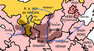
that covers an area of some 640,000 km²
1 E11 m²
To help compare orders of magnitude of different geographical regions we list here surface areas between 100,000 km2 and 1,000,000 km2. See also areas of other orders of magnitude.* Areas smaller than 100,000 km2* 100,000 km2 is equal to:...
in the upper and middle reaches of China
China
Chinese civilization may refer to:* China for more general discussion of the country.* Chinese culture* Greater China, the transnational community of ethnic Chinese.* History of China* Sinosphere, the area historically affected by Chinese culture...
's Yellow River
Yellow River
The Yellow River or Huang He, formerly known as the Hwang Ho, is the second-longest river in China and the sixth-longest in the world at the estimated length of . Originating in the Bayan Har Mountains in Qinghai Province in western China, it flows through nine provinces of China and empties into...
. Loess
Loess
Loess is an aeolian sediment formed by the accumulation of wind-blown silt, typically in the 20–50 micrometre size range, twenty percent or less clay and the balance equal parts sand and silt that are loosely cemented by calcium carbonate...
is the name for the silt
Silt
Silt is granular material of a size somewhere between sand and clay whose mineral origin is quartz and feldspar. Silt may occur as a soil or as suspended sediment in a surface water body...
y sediment
Sediment
Sediment is naturally occurring material that is broken down by processes of weathering and erosion, and is subsequently transported by the action of fluids such as wind, water, or ice, and/or by the force of gravity acting on the particle itself....
that has been deposited by wind storms on the plateau over the ages. Loess is a highly erosion
Erosion
Erosion is when materials are removed from the surface and changed into something else. It only works by hydraulic actions and transport of solids in the natural environment, and leads to the deposition of these materials elsewhere...
-prone soil that is susceptible to the forces of wind and water; in fact, the soil of this region has been called the "most highly erodible soil on earth". The Loess Plateau and its dusty soil cover almost all of Shanxi
Shanxi
' is a province in Northern China. Its one-character abbreviation is "晋" , after the state of Jin that existed here during the Spring and Autumn Period....
and Shaanxi
Shaanxi
' is a province in the central part of Mainland China, and it includes portions of the Loess Plateau on the middle reaches of the Yellow River in addition to the Qinling Mountains across the southern part of this province...
provinces, as well as parts of Gansu
Gansu
' is a province located in the northwest of the People's Republic of China.It lies between the Tibetan and Huangtu plateaus, and borders Mongolia, Inner Mongolia, and Ningxia to the north, Xinjiang and Qinghai to the west, Sichuan to the south, and Shaanxi to the east...
province, the Ningxia Hui Autonomous Region
Ningxia
Ningxia, formerly transliterated as Ningsia, is an autonomous region of the People's Republic of China. Located in Northwest China, on the Loess Plateau, the Yellow River flows through this vast area of land. The Great Wall of China runs along its northeastern boundary...
, and the Inner Mongolia
Inner Mongolia
Inner Mongolia is an autonomous region of the People's Republic of China, located in the northern region of the country. Inner Mongolia shares an international border with the countries of Mongolia and the Russian Federation...
Autonomous Region.
History

Northern Silk Road
The Northern Silk Road is a prehistoric trackway in northern China originating in the early capital of Xi'an and extending north of the Taklamakan Desert to reach the ancient kingdoms of Parthia, Bactria and eventually Persia and Rome. It is the northern-most branch of several Silk Roads providing...
. In the last part of the first millennium BC, after the explorer Zhang Qian
Zhang Qian
Zhang Qian was an imperial envoy to the world outside of China in the 2nd century BCE, during the time of the Han Dynasty...
's return to China, the Han Dynasty
Han Dynasty
The Han Dynasty was the second imperial dynasty of China, preceded by the Qin Dynasty and succeeded by the Three Kingdoms . It was founded by the rebel leader Liu Bang, known posthumously as Emperor Gaozu of Han. It was briefly interrupted by the Xin Dynasty of the former regent Wang Mang...
pushed the Xiongnu
Xiongnu
The Xiongnu were ancient nomadic-based people that formed a state or confederation north of the agriculture-based empire of the Han Dynasty. Most of the information on the Xiongnu comes from Chinese sources...
back and trade and cultural exchange flourished along the Northern Silk Road
Northern Silk Road
The Northern Silk Road is a prehistoric trackway in northern China originating in the early capital of Xi'an and extending north of the Taklamakan Desert to reach the ancient kingdoms of Parthia, Bactria and eventually Persia and Rome. It is the northern-most branch of several Silk Roads providing...
through the southern Loess Plateau. Goods moving by caravan to the west included gold, rubies, jade
Jade
Jade is an ornamental stone.The term jade is applied to two different metamorphic rocks that are made up of different silicate minerals:...
, textiles, coral, ivory and art works. In the opposite direction moved bronze weapons, furs, ceramics
Ceramic
A ceramic is an inorganic, nonmetallic solid prepared by the action of heat and subsequent cooling. Ceramic materials may have a crystalline or partly crystalline structure, or may be amorphous...
and cinnamon bark.
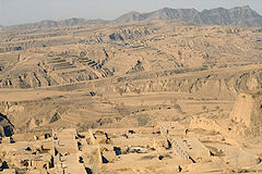
Historically the Loess Plateau has provided simple yet insulated shelter from the cold winter and hot summer in the region, as homes called yaodong
Yaodong
A yaodong or "cave house" is a particular form of earth shelter dwelling common in the Loess Plateau in China's north. They are generally carved out of a hillside or excavated horizontally from a central "sunken courtyard"....
(窰洞) were often carved into the loess soil; in medieval times of China people stayed here to grow rice; some families still live in this kind of shelter in modern times. During the Shaanxi Earthquake
Shaanxi Earthquake
The 1556 Shaanxi earthquake or Jiajing earthquake was a catastrophic earthquake and is also the deadliest earthquake on record, killing approximately 830,000 people. It occurred on the morning of 23 January 1556 in Shaanxi, during the Ming Dynasty...
, nearly a million people were killed as a result of collapsing loess caves. The yaodongs that are best known to the world are perhaps those in Yan'an
Yan'an
Yan'an , is a prefecture-level city in the Shanbei region of Shaanxi province in China, administering several counties, including Zhidan County , which served as the Chinese communist capital before the city of Yan'an proper took that role....
where the Communist Party
Communist Party of China
The Communist Party of China , also known as the Chinese Communist Party , is the founding and ruling political party of the People's Republic of China...
led by Mao Zedong
Mao Zedong
Mao Zedong, also transliterated as Mao Tse-tung , and commonly referred to as Chairman Mao , was a Chinese Communist revolutionary, guerrilla warfare strategist, Marxist political philosopher, and leader of the Chinese Revolution...
headquartered in 1930s. When Edgar Snow
Edgar Snow
Edgar P. Snow was an American journalist known for his books and articles on Communism in China and the Chinese Communist revolution...
, the author of Red Star Over China
Red Star Over China
Red Star Over China, a book by Edgar Snow, is an account of the Communist Party of China written when they were a guerrilla army still obscure to Westerners. Along with Pearl Buck's The Good Earth, it was the most influential book on Western understanding and sympathy for China in the 1930s...
, visited Mao and his party, he lived in a yaodong
Yaodong
A yaodong or "cave house" is a particular form of earth shelter dwelling common in the Loess Plateau in China's north. They are generally carved out of a hillside or excavated horizontally from a central "sunken courtyard"....
which is warm in winter and cool in summer.
Climate
The plateau generally has a semi-arid climate (KöppenKöppen climate classification
The Köppen climate classification is one of the most widely used climate classification systems. It was first published by Crimea German climatologist Wladimir Köppen in 1884, with several later modifications by Köppen himself, notably in 1918 and 1936...
), with extensive monsoonal influence. Winters are cold and dry, while summers are very warm and in many places hot. Rainfall tends to be heavily concentrated in summer, and the area receives extensive amounts of sunshine.
Agriculture and environment
The Loess Plateau was highly fertile and easy to farm in ancient times, which contributed to the development of early Chinese civilization around the Loess Plateau.Centuries of deforestation
Deforestation
Deforestation is the removal of a forest or stand of trees where the land is thereafter converted to a nonforest use. Examples of deforestation include conversion of forestland to farms, ranches, or urban use....
and over-grazing, exacerbated by China's population increase, have resulted in degenerated ecosystem
Ecosystem
An ecosystem is a biological environment consisting of all the organisms living in a particular area, as well as all the nonliving , physical components of the environment with which the organisms interact, such as air, soil, water and sunlight....
s, desertification
Desertification
Desertification is the degradation of land in drylands. Caused by a variety of factors, such as climate change and human activities, desertification is one of the most significant global environmental problems.-Definitions:...
, and poor local economies.
In 1994 an effort known as the Loess Plateau Watershed Rehabilitation Project was launched to mitigate desertification; limited success has resulted for a portion of the Loess Plateau, where now trees and grass have turned green and farmers are busy in their croplands. A major focus of the Project was to try and guide the people living in the Plateau to use more sustainable ways of living such as keeping goats in pens not being allowed to roam free and erode the soft silty soil found in the plateau. Many trees were planted and nature is now reclaiming a portion of the Loess Plateau. Results have reduced the massive silt loads to the Yellow River by about one percent.
The Loess Plateau was formed over long geologic times, and scientists have derived valuable information about global climate change
Climate change
Climate change is a significant and lasting change in the statistical distribution of weather patterns over periods ranging from decades to millions of years. It may be a change in average weather conditions or the distribution of events around that average...
from samples taken from the deep layer of its silty soil.
See also
- Yunnan-Guizhou Plateau
- Loess HillsLoess HillsThe Loess Hills are a formation of wind-deposited loess soil in the westernmost part of Iowa and Missouri along the Missouri River.-Geology:The Loess Hills are generally located between 1 and east of the Missouri River channel...
of Western Iowa
External links
- People's Daily Online: Loess Plateau Rehabilitation Project
- Soils and Sustainability: Tales from the Loess Plateau
- WorldBank: Restoring China's Loess Plateau
- Hope in a Changing Climate - Documentary featuring the restoration of the Loess Plateau

