
Okanagan
Encyclopedia
The Okanagan also known as the Okanagan Valley and sometimes as Okanagan Country is a region located in the Canadian province
of British Columbia
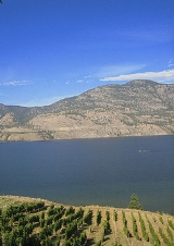
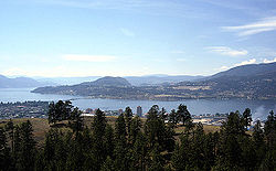
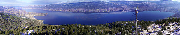
defined by the basin of Okanagan Lake
and the Canadian
portion of the Okanagan River
. As of 2009, the region's population is approximately 350,927. The primary city is Kelowna
. The name derives from the Okanagan language place name ukʷnaqín. An alternate explanation from Washington proposes "People living where you can see the top", ostensibly of Chopaka Peak in the Lower Similkameen. The region is known for its dry, sunny climate, dry landscapes and lakeshore communities and particular lifestyle. The economy is retirement and commercial-recreation based, with outdoor activities such as boating and watersports, snow skiing and hiking. Agriculture has been focused primarily on fruit orchards, with a recent shift in focus to vineyards and wine. The valley stretches from Sicamous, (where it merges with the Shuswap
), to the US Border, where it continues as the Okanogan Valley. The Okanagan Region often includes the Boundary Country
, Similkameen Country
and Shuswap, as well as the Okanagan Valley itself.
, an Interior Salish people who live in the valley from the head of Okanagan Lake
downstream to near the river's confluence with the Columbia River
in present-day Washington, as well as in the neighbouring Similkameen Valley, though the traditional territory encompasses the entire Columbia River watershed. They were hunter-gatherer
s, living off wild game and berries and roots for the most part but travelling north or south to fish salmon run
s or to trade with other nations. Today the member bands of the Okanagan Nation Alliance are sovereign nations, with vibrant natural resource and tourism based economies. The annual August gathering near Vernon is a celebration of the continuance of Okanagan life and culture.
In 1811 the first non-natives came to the Okanagan Valley, a fur trading
expedition voyaging north out of Fort Okanogan
, a Pacific Fur Company
outpost at the confluence of the Okanagan and Columbia Rivers. Within fifteen years, fur traders established a route through the valley for passing goods between the Thompson River
region and the Columbia River for transport to the Pacific. The trade route lasted until 1846, when the Oregon Treaty
laid down the border between British North America
and the United States
west of the Rocky Mountains
on the 49th parallel. The new border cut across the valley. To avoid paying tariff
s, British traders forged a route that bypassed Fort Okanogan via the Fraser Canyon
, following the Thompson, Nicola, Coldwater and Fraser
rivers to Fort Langley instead. The Okanagan Valley did not see many more outsiders for a decade afterward.
 In 1859, the first European settlement was established when Father Charles Pandosy led the making of an Oblate mission
where Kelowna is now. In the decades that followed, hundreds of ranchers came to settle on Okanagan Lake. The Fraser Canyon Gold Rush
of 1858 eventually encouraged more settlement as some prospectors from the United States took the Okanagan Trail
route on their way to the Fraser Canyon
, although at the height of the rush the American adventurers who used the route did not settle because of outright hostilities from the Okanagan people
, whom a few of the parties traversing the trail had harassed and brutalized. A few staked claims around the South Okanagan and Similkameen valleys and found gold
and copper
in places. A mining
industry began in the southern Okanagan region, and more farmers, as well as a small service industry, came to meet the needs of the miners.
Fruit production is a hallmark of the Okanagan Valley today, but the industry began with difficulty. Commercial orcharding of apple
s was first tried there in 1892, but a series of setbacks prevented the major success of commercial fruit crops until the 1920s. But until the 1930s, the demand for shipping fruit and other goods did drive a need for the sternwheeler steamboat
s that serviced Okanagan Lake: the S.S. Aberdeen from 1886 and then the S.S. Sicamous and S.S. Naramata from 1914. The Sicamous and Naramata survive as a tourist attraction in Penticton.
While the last half-century has grown several resource-based enterprises in the region, for instance forestry in Princeton
, the fastest-growing industries in the Okanagan today are real estate
, tourism
and retirement
accommodation as well as the ripping up of orchards and their replacement by wineries and vinyards. Favoured by its sunny climate, lakes, and winery
attractions, the valley has become a popular destination for vacationers and retirees. The area also attracts seasonal fruit-picking labourers, primarily from Quebec
and Mexico.
 As defined for census
purposes by Statistics Canada
, the region has a total area of 20,829 km² (8,042 mi²) which is roughly two-thirds the size of Belgium
.
Geographic features include:
The Indian reserves of the Okanagan first peoples
also form identifiable communities:
In 2009, there were 3,000 Mexican migrant labourers working in the Okanagan.
See Racialization
, Seasonal Agricultural Workers Program
and Racialization of Labour in the Okanagan
.
Provinces and territories of Canada
The provinces and territories of Canada combine to make up the world's second-largest country by area. There are ten provinces and three territories...
of British Columbia
British Columbia
British Columbia is the westernmost of Canada's provinces and is known for its natural beauty, as reflected in its Latin motto, Splendor sine occasu . Its name was chosen by Queen Victoria in 1858...
defined by the basin of Okanagan Lake
Okanagan Lake
Okanagan Lake is a large, deep lake in the Okanagan Valley of British Columbia. The lake is 135 km long, between 4 and 5 km wide, and has a surface area of 351 km². The lake's maximum depth is 232 meters near Grant Island...
and the Canadian
Canada
Canada is a North American country consisting of ten provinces and three territories. Located in the northern part of the continent, it extends from the Atlantic Ocean in the east to the Pacific Ocean in the west, and northward into the Arctic Ocean...
portion of the Okanagan River
Okanogan River
The Okanogan River is a tributary of the Columbia River, approximately 115 mi long, in southern British Columbia and north central Washington...
. As of 2009, the region's population is approximately 350,927. The primary city is Kelowna
Kelowna
Kelowna is a city on Okanagan Lake in the Okanagan Valley, in the southern interior of British Columbia, Canada. Its name derives from a Okanagan language term for "grizzly bear"...
. The name derives from the Okanagan language place name ukʷnaqín. An alternate explanation from Washington proposes "People living where you can see the top", ostensibly of Chopaka Peak in the Lower Similkameen. The region is known for its dry, sunny climate, dry landscapes and lakeshore communities and particular lifestyle. The economy is retirement and commercial-recreation based, with outdoor activities such as boating and watersports, snow skiing and hiking. Agriculture has been focused primarily on fruit orchards, with a recent shift in focus to vineyards and wine. The valley stretches from Sicamous, (where it merges with the Shuswap
Shuswap
Shuswap *Secwepemc - an indigenous people in British Columbia, Canada, also known in English as the Shuswap*Shuswap language - a language spoken by the Secwepemc...
), to the US Border, where it continues as the Okanogan Valley. The Okanagan Region often includes the Boundary Country
Boundary Country
The Boundary Country is a historical designation for a district in southern British Columbia lying, as its name suggests, along the boundary between Canada and the United States. It lies to the east of the southern Okanagan Valley and to the west of the West Kootenay. It is often included in...
, Similkameen Country
Similkameen Country
The Similkameen Country, also referred to as the Similkameen Valley or Similkameen District, but generally referred to simply as The Similkameen or more archaically, Similkameen, is a region roughly coinciding with the basin of the river of the same name in the Southern Interior of British Columbia...
and Shuswap, as well as the Okanagan Valley itself.
History
The Okanagan Valley is home to the Okanagan peopleOkanagan people
The Okanagan people, also spelled Okanogan, are a First Nations and Native American people whose traditional territory spans the U.S.-Canada boundary in Washington state and British Columbia...
, an Interior Salish people who live in the valley from the head of Okanagan Lake
Okanagan Lake
Okanagan Lake is a large, deep lake in the Okanagan Valley of British Columbia. The lake is 135 km long, between 4 and 5 km wide, and has a surface area of 351 km². The lake's maximum depth is 232 meters near Grant Island...
downstream to near the river's confluence with the Columbia River
Columbia River
The Columbia River is the largest river in the Pacific Northwest region of North America. The river rises in the Rocky Mountains of British Columbia, Canada, flows northwest and then south into the U.S. state of Washington, then turns west to form most of the border between Washington and the state...
in present-day Washington, as well as in the neighbouring Similkameen Valley, though the traditional territory encompasses the entire Columbia River watershed. They were hunter-gatherer
Hunter-gatherer
A hunter-gatherer or forage society is one in which most or all food is obtained from wild plants and animals, in contrast to agricultural societies which rely mainly on domesticated species. Hunting and gathering was the ancestral subsistence mode of Homo, and all modern humans were...
s, living off wild game and berries and roots for the most part but travelling north or south to fish salmon run
Salmon run
The salmon run is the time at which salmon swim back up the rivers in which they were born to spawn. All Pacific salmon die after spawning. While most Atlantic salmon die after their first spawn, about 5-10% return to the sea to feed between spawnings. The annual run is a major event for sport...
s or to trade with other nations. Today the member bands of the Okanagan Nation Alliance are sovereign nations, with vibrant natural resource and tourism based economies. The annual August gathering near Vernon is a celebration of the continuance of Okanagan life and culture.
In 1811 the first non-natives came to the Okanagan Valley, a fur trading
Fur trade
The fur trade is a worldwide industry dealing in the acquisition and sale of animal fur. Since the establishment of world market for in the early modern period furs of boreal, polar and cold temperate mammalian animals have been the most valued...
expedition voyaging north out of Fort Okanogan
Fort Okanogan
Fort Okanogan was founded as a fur trade outpost by John Jacob Astor’s Pacific Fur Company in 1811. It was built at the confluence of the Okanogan and Columbia Rivers, in what is now Okanogan County, Washington...
, a Pacific Fur Company
Pacific Fur Company
The Pacific Fur Company was founded June 23, 1810, in New York City. Half of the stock of the company was held by the American Fur Company, owned exclusively by John Jacob Astor, and Astor provided all of the capital for the enterprise. The other half of the stock was ascribed to working partners...
outpost at the confluence of the Okanagan and Columbia Rivers. Within fifteen years, fur traders established a route through the valley for passing goods between the Thompson River
Thompson River
The Thompson River is the largest tributary of the Fraser River, flowing through the south-central portion of British Columbia, Canada. The Thompson River has two main branches called the South Thompson and the North Thompson...
region and the Columbia River for transport to the Pacific. The trade route lasted until 1846, when the Oregon Treaty
Oregon Treaty
The Oregon Treaty is a treaty between the United Kingdom and the United States that was signed on June 15, 1846, in Washington, D.C. The treaty brought an end to the Oregon boundary dispute by settling competing American and British claims to the Oregon Country, which had been jointly occupied by...
laid down the border between British North America
British North America
British North America is a historical term. It consisted of the colonies and territories of the British Empire in continental North America after the end of the American Revolutionary War and the recognition of American independence in 1783.At the start of the Revolutionary War in 1775 the British...
and the United States
United States
The United States of America is a federal constitutional republic comprising fifty states and a federal district...
west of the Rocky Mountains
Rocky Mountains
The Rocky Mountains are a major mountain range in western North America. The Rocky Mountains stretch more than from the northernmost part of British Columbia, in western Canada, to New Mexico, in the southwestern United States...
on the 49th parallel. The new border cut across the valley. To avoid paying tariff
Tariff
A tariff may be either tax on imports or exports , or a list or schedule of prices for such things as rail service, bus routes, and electrical usage ....
s, British traders forged a route that bypassed Fort Okanogan via the Fraser Canyon
Fraser Canyon
The Fraser Canyon is an 84 km landform of the Fraser River where it descends rapidly through narrow rock gorges in the Coast Mountains en route from the Interior Plateau of British Columbia to the Fraser Valley...
, following the Thompson, Nicola, Coldwater and Fraser
Fraser River
The Fraser River is the longest river within British Columbia, Canada, rising at Fraser Pass near Mount Robson in the Rocky Mountains and flowing for , into the Strait of Georgia at the city of Vancouver. It is the tenth longest river in Canada...
rivers to Fort Langley instead. The Okanagan Valley did not see many more outsiders for a decade afterward.
Missionary Oblates of Mary Immaculate
The Missionary Oblates of Mary Immaculate is a missionary religious congregation in the Catholic Church. It was founded on January 25, 1816 by Saint Eugene de Mazenod, a French priest born in Aix-en-Provence in the south of France on August 1, 1782. The congregation was given recognition by Pope...
where Kelowna is now. In the decades that followed, hundreds of ranchers came to settle on Okanagan Lake. The Fraser Canyon Gold Rush
Fraser Canyon Gold Rush
The Fraser Canyon Gold Rush, began in 1858 after gold was discovered on the Thompson River in British Columbia at its confluence with the Nicoamen River. This was a few miles upstream from the Thompson's confluence with the Fraser River at present-day Lytton...
of 1858 eventually encouraged more settlement as some prospectors from the United States took the Okanagan Trail
Okanagan Trail
The Okanagan Trail was an inland route to the Fraser Canyon Gold Rush from the Lower Columbia region of the Washington and Oregon Territories in 1858-1859...
route on their way to the Fraser Canyon
Fraser Canyon
The Fraser Canyon is an 84 km landform of the Fraser River where it descends rapidly through narrow rock gorges in the Coast Mountains en route from the Interior Plateau of British Columbia to the Fraser Valley...
, although at the height of the rush the American adventurers who used the route did not settle because of outright hostilities from the Okanagan people
Okanagan people
The Okanagan people, also spelled Okanogan, are a First Nations and Native American people whose traditional territory spans the U.S.-Canada boundary in Washington state and British Columbia...
, whom a few of the parties traversing the trail had harassed and brutalized. A few staked claims around the South Okanagan and Similkameen valleys and found gold
Gold
Gold is a chemical element with the symbol Au and an atomic number of 79. Gold is a dense, soft, shiny, malleable and ductile metal. Pure gold has a bright yellow color and luster traditionally considered attractive, which it maintains without oxidizing in air or water. Chemically, gold is a...
and copper
Copper
Copper is a chemical element with the symbol Cu and atomic number 29. It is a ductile metal with very high thermal and electrical conductivity. Pure copper is soft and malleable; an exposed surface has a reddish-orange tarnish...
in places. A mining
Mining
Mining is the extraction of valuable minerals or other geological materials from the earth, from an ore body, vein or seam. The term also includes the removal of soil. Materials recovered by mining include base metals, precious metals, iron, uranium, coal, diamonds, limestone, oil shale, rock...
industry began in the southern Okanagan region, and more farmers, as well as a small service industry, came to meet the needs of the miners.
Fruit production is a hallmark of the Okanagan Valley today, but the industry began with difficulty. Commercial orcharding of apple
Apple
The apple is the pomaceous fruit of the apple tree, species Malus domestica in the rose family . It is one of the most widely cultivated tree fruits, and the most widely known of the many members of genus Malus that are used by humans. Apple grow on small, deciduous trees that blossom in the spring...
s was first tried there in 1892, but a series of setbacks prevented the major success of commercial fruit crops until the 1920s. But until the 1930s, the demand for shipping fruit and other goods did drive a need for the sternwheeler steamboat
Steamboat
A steamboat or steamship, sometimes called a steamer, is a ship in which the primary method of propulsion is steam power, typically driving propellers or paddlewheels...
s that serviced Okanagan Lake: the S.S. Aberdeen from 1886 and then the S.S. Sicamous and S.S. Naramata from 1914. The Sicamous and Naramata survive as a tourist attraction in Penticton.
While the last half-century has grown several resource-based enterprises in the region, for instance forestry in Princeton
Princeton, British Columbia
Princeton is a small town in the Similkameen region of southern British Columbia, Canada. It lies just east of the Cascade Mountains, which continue south into Washington, Oregon and California. The Tulameen and Similkameen Rivers converge here...
, the fastest-growing industries in the Okanagan today are real estate
Real estate
In general use, esp. North American, 'real estate' is taken to mean "Property consisting of land and the buildings on it, along with its natural resources such as crops, minerals, or water; immovable property of this nature; an interest vested in this; an item of real property; buildings or...
, tourism
Tourism
Tourism is travel for recreational, leisure or business purposes. The World Tourism Organization defines tourists as people "traveling to and staying in places outside their usual environment for not more than one consecutive year for leisure, business and other purposes".Tourism has become a...
and retirement
Retirement
Retirement is the point where a person stops employment completely. A person may also semi-retire by reducing work hours.Many people choose to retire when they are eligible for private or public pension benefits, although some are forced to retire when physical conditions don't allow the person to...
accommodation as well as the ripping up of orchards and their replacement by wineries and vinyards. Favoured by its sunny climate, lakes, and winery
Winery
A winery is a building or property that produces wine, or a business involved in the production of wine, such as a wine company. Some wine companies own many wineries. Besides wine making equipment, larger wineries may also feature warehouses, bottling lines, laboratories, and large expanses of...
attractions, the valley has become a popular destination for vacationers and retirees. The area also attracts seasonal fruit-picking labourers, primarily from Quebec
Quebec
Quebec or is a province in east-central Canada. It is the only Canadian province with a predominantly French-speaking population and the only one whose sole official language is French at the provincial level....
and Mexico.
Climate
Like much of Southern BC, the Okanagan receives a mild climate, although the Okanagan is considerably drier than many other areas. Areas in the north end of the valley receive more precipitation and cooler temperatures than areas to the south. Generally, Kelowna is the transition zone between the drier south and the wetter north. Vegetation also ranges from cactus and sagebrush in the south, to Cedar and Hemlock trees in the North.Geography
Census
A census is the procedure of systematically acquiring and recording information about the members of a given population. It is a regularly occurring and official count of a particular population. The term is used mostly in connection with national population and housing censuses; other common...
purposes by Statistics Canada
Statistics Canada
Statistics Canada is the Canadian federal government agency commissioned with producing statistics to help better understand Canada, its population, resources, economy, society, and culture. Its headquarters is in Ottawa....
, the region has a total area of 20,829 km² (8,042 mi²) which is roughly two-thirds the size of Belgium
Belgium
Belgium , officially the Kingdom of Belgium, is a federal state in Western Europe. It is a founding member of the European Union and hosts the EU's headquarters, and those of several other major international organisations such as NATO.Belgium is also a member of, or affiliated to, many...
.
Geographic features include:
- Kalamalka LakeKalamalka LakeKalamalka Lake is a large lake in the Interior Plateau of southern central British Columbia, Canada, east of Okanagan Lake and approximately south of Vernon. The lake is named for the Okanagan Kalamalka Lake (aka "Kal Lake") is a large lake in the Interior Plateau of southern central British...
- Mahoney LakeMahoney Lake-External links:*...
- Mara LakeMara LakeMara Lake is a lake in the Shuswap Country of the Southern Interior of British Columbia, Canada, located immediately south of the community of Sicamous and to the north of the community of Enderby. It is the outlet of the Shuswap River, which begins in the Monashee Mountains to the east...
- Monashee MountainsMonashee MountainsThe Monashee Mountains are a mountain range mostly in British Columbia, Canada, extending into the U.S. state of Washington. They stretch from north to south and from east to west. They are a subrange of the Columbia Mountains...
- Okanagan HighlandOkanagan HighlandThe Okanagan Highland is a plateau-like hilly area in British Columbia, Canada, and the U.S. state of Washington . It lies between the Okanagan Valley on its west and the Kettle River on its east, and geologically is more or less an extension of the Thompson Plateau, which lies west of the Okanagan...
- Okanagan LakeOkanagan LakeOkanagan Lake is a large, deep lake in the Okanagan Valley of British Columbia. The lake is 135 km long, between 4 and 5 km wide, and has a surface area of 351 km². The lake's maximum depth is 232 meters near Grant Island...
- Okanagan River
- Osoyoos LakeOsoyoos LakeOsoyoos Lake is a lake located in British Columbia and Washington. Osoyoos is derived from the word suius meaning "narrowing of the waters" in the local Okanagan language ....
- Shuswap RiverShuswap RiverThe basin of the Shuswap River lies northeast of the Okanagan Valley in British Columbia. It is the upper part of the drainage better known to British Columbians as belonging to Shuswap Lake and the South Thompson River...
- Skaha LakeSkaha LakeSkaha Lake, historically known as Dog Lake and originally Lac Du Chien, is a freshwater lake located along the course of the Okanagan River in the Okanagan Valley of British Columbia, Canada. It has a surface area of approximately 20 km², with a maximum depth of 55 metres...
- Swan LakeSwan Lake, British ColumbiaIn the Canadian province of British Columbia, Swan Lake may refer to:* Swan Lake , a lake north of Vernon** Swan Lake Indian Reserve No...
- Thompson PlateauThompson PlateauThe Thompson Plateau, also known as the Okanagan-Thompson Plateau, forms the southern portion of the Interior Plateau of British Columbia, Canada, lying to the west of Okanagan Lake, south of the Thompson River and to the east of the Fraser River...
- Tuc-el-nuit Lake
- Vaseaux Lake
- Wood Lake
Major highways
- Highway 97 (Okanagan Highway)British Columbia provincial highway 97Highway 97 is the longest continuously-numbered route in the Canadian province of British Columbia , running 2,081 km from the Canada/U.S. border at Osoyoos in the south to the British Columbia/Yukon border in the north at Watson Lake, Yukon. The route takes its number from U.S...
- Highway 3 (Crowsnest Highway)Crowsnest HighwayThe Crowsnest Highway, also known as the Interprovincial or, in British Columbia, the Southern Trans-Provincial, is an east-west highway, in length, through the southern parts of British Columbia and Alberta, providing the shortest highway connection between British Columbia's Lower Mainland and...
- Highway 97C (Okanagan Connector)British Columbia provincial highway 97CHighway 97C, the Okanagan Connector or Coquihalla Connector, forms part of an important link between the Lower Mainland and the Okanagan Valley around Kelowna. It bisects the Coquihalla Highway at Merritt...
- Highway 33British Columbia provincial highway 33Highway 33 is a minor two-lane highway in the Okanagan region of the province. Highway 33, which is 129 km long, connects Rock Creek, on the Crowsnest Highway, north to Kelowna, on the Okanagan Highway, partially following the West Kettle River. It is also the main access to the Big White...
- Highway 6British Columbia provincial highway 6British Columbia Highway 6 is a two-lane east-west highway passing between the Kootenay and Okanagan regions. It is divided into two parts—the Nelson-Nelway Highway to the south, and the Vernon-Slocan Highway to the north...
- Highway 97A
Adjacent regions
- Thompson CountryThompson CountryThe Thompson Country, also referred to as The Thompson and in some ways as the Thompson Valley and historically known as the Couteau Country or Couteau District, is a historic geographic region of the Southern Interior of British Columbia, based around the basin of the Thompson River, a tributary...
- Northwest - Shuswap CountryShuswap CountryThe Shuswap Country, or simply "the Shuswap" is a term used in the Canadian province of British Columbia to refer to the environs of Shuswap Lake. The upper reaches of the Shuswap basin, southeast of Shuswap Lake and northeast of the Okanagan, are generally considered to be part of Okanagan or of...
- North - Boundary CountryBoundary CountryThe Boundary Country is a historical designation for a district in southern British Columbia lying, as its name suggests, along the boundary between Canada and the United States. It lies to the east of the southern Okanagan Valley and to the west of the West Kootenay. It is often included in...
, Arrow LakesArrow LakesThe Arrow Lakes in British Columbia, Canada, divided into Upper Arrow Lake and Lower Arrow Lake, are widenings of the Columbia River. The lakes are situated between the Selkirk Mountains to the east and the Monashee Mountains to the west. Beachland is fairly rare, and is interspersed with rocky...
, Slocan ValleySlocan ValleyThe Slocan Valley is a valley in the West Kootenay region of British Columbia, Canada.The valley is home to the villages of Slocan City, New Denver, Silverton, as well as the unincorporated communities of Crescent Valley, Slocan Park, Passmore, Vallican, Winlaw, Appledale, Perry Siding, Lemon...
and West KootenayKootenaysThe Kootenay Region comprises the southeastern portion of British Columbia. It takes its name from the Kootenay River, which in turn was named for the Ktunaxa First Nation first encountered by explorer David Thompson.-Boundaries:The Kootenays are more or less defined by the Kootenay Land...
- East - Similkameen CountrySimilkameen CountryThe Similkameen Country, also referred to as the Similkameen Valley or Similkameen District, but generally referred to simply as The Similkameen or more archaically, Similkameen, is a region roughly coinciding with the basin of the river of the same name in the Southern Interior of British Columbia...
and Nicola CountryNicola CountryThe Nicola Country, also known as the Nicola Valley and often referred to simply as The Nicola, and originally Nicolas' Country or Nicholas' Country, adapted to Nicola's Country and simplified since, is a region in the Southern Interior of British Columbia, Canada...
- West - Okanogan County, Washington, USA - South
Communities
- ArmstrongArmstrong, British ColumbiaThe City of Armstrong is located in the North Okanagan of the Canadian province of British Columbia, between Vernon and Enderby. It overlooks the Spallumcheen Valley, which forms a broad pass between the Okanagan Valley to the south and the Shuswap Country to the north, and is about from each of...
- ColdstreamColdstream, British ColumbiaColdstream is a district municipality in British Columbia, Canada, located at the northern end of Kalamalka Lake in the Okanagan Valley. Incorporated on December 21, 1906, Coldstream celebrated its centennial in 2006. The municipality is directly southeast of Vernon and is considered part of...
- GrindrodGrindrod, British ColumbiaGrindrod is a settlement in British Columbia.History of Grindrod: http://www.gri.sd83.bc.ca/GrindrodHistory...
- EnderbyEnderby, British ColumbiaThe City of Enderby is in the North Okanagan of the Canadian province of British Columbia, between Armstrong and Salmon Arm. It is approximately 80 km north of Kelowna and 130 km east of Kamloops...
- KaledenKaleden, British ColumbiaKaleden is a small historic community located minutes south of Penticton in the Okanagan valley in the province of British Columbia Canada. Overlooking Skaha Lake, Kaleden is made up of picturesque vineyards and lakeview orchards. Visitors are offered a relaxed environment with good bed and...
- KelownaKelownaKelowna is a city on Okanagan Lake in the Okanagan Valley, in the southern interior of British Columbia, Canada. Its name derives from a Okanagan language term for "grizzly bear"...
- Rutland
- Okanagan Mission
- Lake CountryLake Country, British ColumbiaLake Country is a District Municipality with a population of approximately 10,000 in the Okanagan Valley, British Columbia, Canada. The city of Kelowna lies to the south, while the city of Vernon lies to the north. As its name suggests, there are a number of lakes in the vicinity of Lake Country,...
- Oyama
- WinfieldWinfield, British ColumbiaWinfield is an urban area that is currently part of the District Municipality of Lake Country, British Columbia, located north of Kelowna, British Columbia, Canada. The community is situated north and slightly east of Kelowna, along Highway 97, located in the central Okanagan Valley. The town is...
- Carr's (Carr's Landing)
- Okanagan Centre
- Lavington
- LumbyLumby, British ColumbiaLumby is a small community of 1,804, located at the northeast corner of the Okanagan Valley, in the Canadian province of British Columbia. It is mainly a logging, manufacturing and agriculture community, but tourism is a growing trend within the area....
- NaramataNaramata, British Columbia-External links:*...
- Okanagan FallsOkanagan Falls, British ColumbiaOkanagan Falls is a community located on the south end of Skaha Lake in British Columbia. Originally named Dogtown, which was derived from the name Dog Lake , the current name derives from the former small set of the falls that used to lie on the Okanagan River at the outlet of the lake.-References:...
- OlallaOlalla, British ColumbiaOlalla is an unincorporated settlement in the South Okanagan region of the Southern Interior of British Columbia, Canada, located southwest of Penticton and just north of Keremeos...
- OliverOliver, British ColumbiaOliver is a community at the south end of the Okanagan Valley in the Southern Interior of British Columbia, Canada, with a population of 4370. The community of Oliver is made up of land governed by three different bodies: the Town of Oliver, the Regional District of Okanagan-Similkameen and the...
- FairviewFairview, British ColumbiaFairview is a ghost town in British Columbia near the Town of Oliver. It is famous for the Fairview Hotel that burnt down in the 1900s.There are many things that can still be visited at Fairview such as the Fairview Cemetery on Fairview Road, the stampmill on Tinhorn Creek Road, and the many mines...
- Fairview
- OsoyoosOsoyoos, British ColumbiaOsoyoos is a town in the southern part of the Okanagan Valley in British Columbia near the border with Washington state. The town is also adjacent to the Indian Reserve of the Osoyoos Indian Band. The origin of the name Osoyoos was the word suius meaning "narrowing of the waters" in the local...
- PeachlandPeachland, British ColumbiaPeachland is a district municipality of approximately 5000 residents in the Okanagan Valley, on the west side of Okanagan Lake in British Columbia, Canada. It was founded in 1899 by John Moore Robinson, although the region had long been home to the Okanagan people...
- Penticton
- SpallumcheenSpallumcheen, British ColumbiaSpallumcheen is a district municipality in the Canadian province of British Columbia. Located in the Okanagan region between Vernon and Enderby, the township had a population of 4,960 in the Canada 2006 Census...
- SummerlandSummerland, British ColumbiaSummerland is a community on the west side of Okanagan Lake in the interior of British Columbia, Canada. The district is between Peachland to the north and Penticton to the south...
- VernonVernon, British ColumbiaVernon is a city in the south-central region of British Columbia, Canada. Named after Forbes George Vernon, a former MLA of British Columbia who helped found the famed Coldstream Ranch, the City of Vernon was incorporated on December 30, 1892. The City of Vernon has a population of 35,944 , while...
- West Kelowna (district)
- Lakeview HeightsLakeview Heights, British ColumbiaLakeview Heights is a rural community within the incorporated District of West Kelowna, British Columbia, Canada. Lakeview Heights and the rest of West Kelowna is on the west side of Okanagan Lake, across the lake from Kelowna...
- WestbankWestbank, British ColumbiaWestbank is one of the communities within the district municipality of West Kelowna in the province of British Columbia. It is 12 km to the west of Kelowna. Other communities in West Kelowna include Casa Loma, West Kelowna Estates, Shannon Lake, Smith Creek, Glenrosa, Rose Valley and Lakeview...
- Lakeview Heights
The Indian reserves of the Okanagan first peoples
Okanagan Nation Alliance
The Okanagan Nation Alliance is a First Nations Tribal Council in the Canadian province of British Columbia, spanning the Nicola, Okanagan and Similkameen Districts of the Canadian province of British Columbia and also the Colville Indian Reservation in Washington state.-Member...
also form identifiable communities:
- Osoyoos Indian BandOsoyoos Indian BandThe Osoyoos Indian Band is a First Nations government in the Canadian province of British Columbia, located in the town of Osoyoos in the Okanagan valley, about four kilometres north of the International Border. They are a member of the Okanagan Nation Alliance...
- Penticton Indian BandPenticton Indian BandThe Penticton Indian Band is a First Nations government in the Canadian province of British Columbia, located next to the city of Penticton in the Okanagan Valley. They are a member of the Okanagan Nation Alliance.-Indian Reserves:...
- Westbank First NationWestbank First NationThe Westbank First Nation is a First Nations government in the Okanagan region of the Canadian province of British Columbia, located with the District of West Kelowna. They are a member of the Okanagan Nation Alliance...
Demographics
The population of the region was 350 927, as of the 2009 CB stats estimates. http://www.bcstats.gov.bc.ca/data/pop/pop/estspop.asp#totpopRacialization of Agricultural Labour
The continued growth and operation of the agricultural industry in the Okanagan absolutely depends on the employment of temporary migrant workers.In 2009, there were 3,000 Mexican migrant labourers working in the Okanagan.
See Racialization
Racialization
Racialization refers to processes of the discursive production of racial identities. It signifies the extension of dehumanizing and racial meanings to a previously racially unclassified relationship, social practice, or group...
, Seasonal Agricultural Workers Program
Seasonal Agricultural Workers Program
The Seasonal Agricultural Workers Program is a Canadian government program is intended to allow workers from Mexico and the Caribbean to immigrate to Canada for temporary support during the planting and harvesting seasons, when there is no help available from within Canada.The program is available...
and Racialization of Labour in the Okanagan
Racialization of Labour in the Okanagan
The continued growth and operation of the agricultural industry in the Okanagan absolutely depends on the employment of temporary migrant workers.In 2009, there were 3,000 Mexican migrant labourers working in the Okanagan.-Introduction to Racialization of Labour:...
.