

Arrow Lakes
Encyclopedia
British Columbia
British Columbia is the westernmost of Canada's provinces and is known for its natural beauty, as reflected in its Latin motto, Splendor sine occasu . Its name was chosen by Queen Victoria in 1858...
, Canada
Canada
Canada is a North American country consisting of ten provinces and three territories. Located in the northern part of the continent, it extends from the Atlantic Ocean in the east to the Pacific Ocean in the west, and northward into the Arctic Ocean...
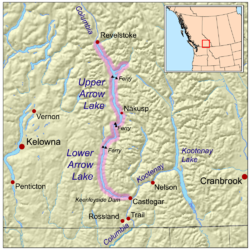
, divided into Upper Arrow Lake and Lower Arrow Lake, are widenings of the Columbia River
Columbia River
The Columbia River is the largest river in the Pacific Northwest region of North America. The river rises in the Rocky Mountains of British Columbia, Canada, flows northwest and then south into the U.S. state of Washington, then turns west to form most of the border between Washington and the state...
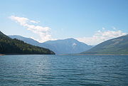
. The lakes are situated between the Selkirk Mountains
Selkirk Mountains
The Selkirk Mountains are a mountain range spanning the northern portion of the Idaho Panhandle, eastern Washington, and southeastern British Columbia. They begin at Mica Peak near Coeur d'Alene, Idaho and extend approximately 320 km north from the border. The range is bounded on its west,...
to the east and the Monashee Mountains
Monashee Mountains
The Monashee Mountains are a mountain range mostly in British Columbia, Canada, extending into the U.S. state of Washington. They stretch from north to south and from east to west. They are a subrange of the Columbia Mountains...
to the west. Beachland is fairly rare, and is interspersed with rocky headlands and steep cliffs. Mountain sides are heavily forested, and rise sharply to elevations around 2,600 metres.
Keenleyside Dam
Hugh Keenleyside Dam is a hydroelectric dam spanning the Columbia River, 12 km upstream of the city of Castlegar, British Columbia, Canada....
; at low water the two lakes remain distinct, connected by a fast-moving section known as the Narrows. Damming the lake resulted in water rising 12 meters above natural levels. As a result of higher water, the valley lost 2/3 of its arable land. Thousands of people relocated. The lake stretches from just north of Castlegar
Castlegar, British Columbia
Castlegar is the second largest city in the West Kootenay region of British Columbia, Canada. It is located within the Selkirk Mountains at the confluence of the Kootenay and Columbia Rivers. It is a regional trade and transportation centre, with a local economy fueled by forestry, mining and tourism...
in the south to Revelstoke
Revelstoke, British Columbia
Revelstoke is a city in southeastern British Columbia, Canada. It is located east of Vancouver, and west of Calgary, Alberta. The city is situated on the banks of the Columbia River just south of the Revelstoke Dam and near its confluence with the Illecillewaet River...
in the north. Another hydroelectric development diverted Whatshan Lake from the Whatshan River
Whatshan River
The Whatshan River is a tributary of the Columbia River in the Canadian province of British Columbia. The river's drainage basin is approximately in area.-Course:...
directly into the Arrow Lakes, just north of the Needles-Fauquier Ferry.
There are two free highway ferries across the Upper Arrow Lake: the Upper Arrow Lakes Ferry between Shelter Bay
Shelter Bay, British Columbia
Shelter Bay is a ferry landing and unincorporated locality on Upper Arrow Lake in British Columbia, Canada.It serves as one terminus of the Upper Arrow Lakes Ferry, that crosses the lake to Galena Bay. This ferry connects British Columbia Highway 23 from Revelstoke to that highway's continuation...
and Galena Bay
Galena Bay, British Columbia
Galena Bay is an unincorporated locality on the bay of the same name on Upper Arrow Lake in British Columbia, Canada.Galena Bay is the location of a terminal of the Upper Arrow Lakes Ferry. This linking Galena Bay to Shelter Bay, the link forming part of British Columbia Highway 23 from Nakusp to...
at the northern end of Upper Arrow Lake; and the Needles Cable Ferry further south, on BC Hwy 6
British Columbia provincial highway 6
British Columbia Highway 6 is a two-lane east-west highway passing between the Kootenay and Okanagan regions. It is divided into two parts—the Nelson-Nelway Highway to the south, and the Vernon-Slocan Highway to the north...
between Nakusp
Nakusp, British Columbia
The Village of Nakusp is a small community located on the shores of Upper Arrow Lake, a portion of the Columbia River, in the West Kootenay region of British Columbia...
and Vernon
Vernon, British Columbia
Vernon is a city in the south-central region of British Columbia, Canada. Named after Forbes George Vernon, a former MLA of British Columbia who helped found the famed Coldstream Ranch, the City of Vernon was incorporated on December 30, 1892. The City of Vernon has a population of 35,944 , while...
. There is also the Arrow Park Ferry, a cable ferry connecting East Arrow Park and West Arrow Park about 28 km south of Nakusp.
The Arrow Lakes are part of the traditional territory claims of the Sinixt
Sinixt
The Sinixt are a First Nations People...
, Okanagan
Okanagan people
The Okanagan people, also spelled Okanogan, are a First Nations and Native American people whose traditional territory spans the U.S.-Canada boundary in Washington state and British Columbia...
and Ktunaxa peoples, though at the time of contact and during colonization only Sinixt lived along its shores.
Name origin
Castlegar, British Columbia
Castlegar is the second largest city in the West Kootenay region of British Columbia, Canada. It is located within the Selkirk Mountains at the confluence of the Kootenay and Columbia Rivers. It is a regional trade and transportation centre, with a local economy fueled by forestry, mining and tourism...
, opposite the community of Renata, a large rock outcrop or overhang above the water, in the face of which was a hole filled with arrows. Different stories surround the meaning of the arrows, said to be shot there by the Lakes people (Sinixt) for good luck, either before or after war:
On October 19, 1826, while travelling south between Upper and Lower Arrow Lakes, Simpson passed "...The Arrow Rock, so named on account of a round hole in the face full of Arrows, said to have been fired at it by the Indians when practicing the Bow and Arrow before a war excursion." (Journal of Emilius Simpson; HBC Archives' accession B223/a/3 1826 Folio 39D-41) Source: included with note
In the days before Columbus was born, the 'Indians' of the west and east Kootenay were at continual strife. It was customary for the west Kootenay Indians to winter along the southern Columbia and to ascend the stream every summer, to the lakes where hunting was good. As the tribes in the Slocan were always on the alert for war, they had their scouts out on the Arrow Lakes to note when their enemies came up the river. One summer the scouts returned from the [Arrow] Lakes with news that a particularly large force of warriors were going up the river. So the Slocan tribes prepared for war and crossed the mountains in force to Nakusp. On embarking from their canoes at Nakusp (the bay behind the long point) they noticed signs of a great storm having passed. On proceeding up the lake for some distance they came upon the force of the enemy. But alas ! There were none to resist them, for the great storm had apparently come suddenly upon them and there was nothing left but a heaving mass of canoe wreckage and dead bodies. The Slocan Indians took this as a great favour from the great 'Manatoo', and in token of respect they fired all their arrows at the high rock off which they lay, and wrote inscriptions on the face of the rock. Because of the vast wealth of arrow heads that fell to the bottom of the lake that day, the Indians named it Arrow Lake. (Relayed by Richard Blyth, as told to him by Chief Louis Joseph, Burton.) Source: BC place name cards, or correspondence to/from BC's Chief Geographer or BC Geographical Names Office.