
Kootenays
Encyclopedia
The Kootenay Region (in common parlance "The Kootenays") comprises the southeastern portion of British Columbia
. It takes its name from the Kootenay River
, which in turn was named for the Ktunaxa
(or Kootenai or Kutenai) First Nation first encountered by explorer David Thompson
.
 The Kootenays are more or less defined by the Kootenay Land District, though some variation exists in terms of what areas are or are not a part. The strictest definition of the region is the drainage basin
of the lower Kootenay River
from its re-entry into Canada near Creston
, through to its confluence with the Columbia
at Castlegar
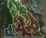
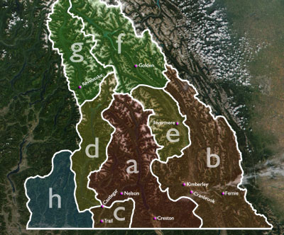
(illustrated by a, right). In most interpretations, however, the region also includes:
Some or all of the following areas to the north, which drain into the Columbia River, are also commonly included in the Kootenays:
When the above regions are added, sometimes the region's name is morphed into Columbia-Kootenay or Kootenay-Columbia, although that terminology also includes the Big Bend Country and Kinbasket Lake, to the north of Golden and Revelstoke, which is not generally considered part of the Kootenays, though part of the Kootenay Land District.
Finally, the Boundary Country
, a southern east-west corridor between the Okanagan
and the Bonanza Pass
and drained by the basins of the Kettle
and Granby River
s, is sometimes mentioned as being in the West Kootenay, and in other reckonings as being part of the Okanagan. In actuality, the settlement of the Boundary Country predates development in either of the regions it is now attached to, as is also the case with the Similkameen Country
to the west of the Okanagan. In some descriptions, the Boundary Country includees Osoyoos and Oliver in the South Okanagan (rather than the other way around). The Boundary Country is (illustrated by h) In the event of its inclusion, the Kootenays could be described as the complete Canadian portion of the Columbia Basin
minus lands drained by the Okanagan River.
It remains unclear why both Kootenay and Kootenays are used somewhat interchangeably to describe the area. The plural form is in reference to The Kootenays, both East and West, the singular is in reference to the Kootenay Region. In practice the two terms are used interchangeably, although one indicates a geographical region and the other a legal boundary, the Kootenay Land District, which was identical with the original federal and provincial Kootenay ridings
.
) and numerous commercial centers, including Trail
, Nelson
, Cranbrook
, Kimberley
, Fernie
, Castlegar
, Rossland
, and Creston
.
A number of Community Radio
stations have developed in the region, most notably CJLY-FM
in Nelson and CIDO-FM
in Creston. These stations usually operate either as a Cooperative
or as a non profit Society
.
British Columbia
British Columbia is the westernmost of Canada's provinces and is known for its natural beauty, as reflected in its Latin motto, Splendor sine occasu . Its name was chosen by Queen Victoria in 1858...
. It takes its name from the Kootenay River
Kootenay River
The Kootenay is a major river in southeastern British Columbia, Canada and the northern part of the U.S. states of Montana and Idaho. It is one of the uppermost major tributaries of the Columbia River, which is the largest North American river that empties into the Pacific Ocean...
, which in turn was named for the Ktunaxa
Ktunaxa Kinbasket Tribal Council
The Ktunaxa Kinbasket Tribal Council, formerly the Kootenay Indian Area Council and also known as the Ktunaxa Nation Council, is a First Nations tribal council government composed of bands in the East Kootenay area of the Canadian province of British Columbia and adjoining parts of the U.S...
(or Kootenai or Kutenai) First Nation first encountered by explorer David Thompson
David Thompson (explorer)
David Thompson was an English-Canadian fur trader, surveyor, and map-maker, known to some native peoples as "Koo-Koo-Sint" or "the Stargazer"...
.
Boundaries
Drainage basin
A drainage basin is an extent or an area of land where surface water from rain and melting snow or ice converges to a single point, usually the exit of the basin, where the waters join another waterbody, such as a river, lake, reservoir, estuary, wetland, sea, or ocean...
of the lower Kootenay River
Kootenay River
The Kootenay is a major river in southeastern British Columbia, Canada and the northern part of the U.S. states of Montana and Idaho. It is one of the uppermost major tributaries of the Columbia River, which is the largest North American river that empties into the Pacific Ocean...
from its re-entry into Canada near Creston
Creston, British Columbia
Creston is a town of 4,826 people in the Kootenay region of southeastern British Columbia, Canada. The town is located just a few kilometers north of the Porthill, Idaho border crossing into the United States and about a three-hour drive north from Spokane, Washington. It is about a one-hour drive...
, through to its confluence with the Columbia
Columbia River
The Columbia River is the largest river in the Pacific Northwest region of North America. The river rises in the Rocky Mountains of British Columbia, Canada, flows northwest and then south into the U.S. state of Washington, then turns west to form most of the border between Washington and the state...
at Castlegar
Castlegar, British Columbia
Castlegar is the second largest city in the West Kootenay region of British Columbia, Canada. It is located within the Selkirk Mountains at the confluence of the Kootenay and Columbia Rivers. It is a regional trade and transportation centre, with a local economy fueled by forestry, mining and tourism...
(illustrated by a, right). In most interpretations, however, the region also includes:
- an area to the east which encompasses the upper drainage basin of the Kootenay River from its rise in the Rocky MountainsRocky MountainsThe Rocky Mountains are a major mountain range in western North America. The Rocky Mountains stretch more than from the northernmost part of British Columbia, in western Canada, to New Mexico, in the southwestern United States...
to its passage into the U.S.A. at Newgate. This adds a region spanning from the Purcell MountainsPurcell MountainsThe Purcell Mountains are a mountain range in southeastern British Columbia, Canada. They are a subrange of the Columbia Mountains, which includes the Selkirk, Monashee, and Cariboo Mountains. They are located on the west side of the Rocky Mountain Trench in the area of the Columbia Valley, and on...
to the AlbertaAlbertaAlberta is a province of Canada. It had an estimated population of 3.7 million in 2010 making it the most populous of Canada's three prairie provinces...
border, and includes Rocky Mountain TrenchRocky Mountain TrenchThe Rocky Mountain Trench, or the Trench or The Valley of a Thousand Peaks, is a large valley in the northern part of the Rocky Mountains. It is both visually and cartographically a striking physiographic feature extending approximately from Flathead Lake, Montana, to the Liard River, just south...
cities such as CranbrookCranbrook, British ColumbiaCranbrook, British Columbia is a city in southeast British Columbia, located on the west side of the Kootenay River at its confluence with the St. Mary's River, It is the largest urban centre in the region known as the East Kootenay. As of 2006, Cranbrook's population is 18,267, and the...
and KimberleyKimberley, British ColumbiaKimberley is a small city in southeast British Columbia, Canada along Highway 95A between the Purcell and Rocky Mountains. Kimberley was named in 1896 after the Kimberley mine in South Africa. From 1917 to 2001, it was the home to the world's largest lead-zinc mine, the Sullivan Mine...
and the Elk ValleyElk ValleyElk Valley is a valley in southeastern British Columbia that runs via the basin of the Elk River from the southeastern Alberta border near Kananaskis to the Rocky Mountain Trench...
of the southern Canadian RockiesCanadian RockiesThe Canadian Rockies comprise the Canadian segment of the North American Rocky Mountains range. They are the eastern part of the Canadian Cordillera, extending from the Interior Plains of Alberta to the Rocky Mountain Trench of British Columbia. The southern end borders Idaho and Montana of the USA...
, centred on FernieFernie, British ColumbiaFernie is a city in the Elk Valley area of the East Kootenay region of southeastern British Columbia, Canada, located on BC Highway 3 on the eastern approaches to the Crowsnest Pass through the Rocky Mountains...
. This region also includes part of the Flathead RiverFlathead RiverThe Flathead River, in the northwestern part of the U.S. state of Montana, originates in the Rocky Mountains near Glacier National Park and flows southwest into Flathead Lake, then after a journey of , empties into the Clark Fork. The river is part of the Columbia River drainage basin, as the Clark...
drainage basin. (illustrated by b) - an area to the southwest encompassing the Columbia's drainage from the Kootenay confluence south to the U.S. Border plus the Salmo RiverSalmo RiverThe Salmo River is a tributary of the Pend d'Oreille River in the Canadian province of British Columbia. The Salmo River is part of the Columbia River drainage basin, being a tributary of the Pend d'Oreille River, which flows into the Columbia River....
basin. This adds the communities of RosslandRossland, British ColumbiaRossland is a city in the West Kootenay region of British Columbia.Tucked high in the Monashee Mountains, Rossland is at an elevation of 1023 metres . Population today is approximately 3500; a number that fluctuates from season to season. The population is at its peak during the winter...
, TrailTrail, British ColumbiaTrail is a city in the West Kootenay region of the Interior of British Columbia, Canada.-Geography:Trail has an area of . The city is located on both banks of the Columbia River, approximately 10 km north of the United States border. This section of the Columbia River valley is located between the...
, FruitvaleFruitvale, British ColumbiaFruitvale is a village located in south-eastern British Columbia in the West Kootenay region.It is located 16 km east of the city of Trail along Highway 3B.-Geography:...
and SalmoSalmo, British ColumbiaSalmo is a village in the West Kootenay region of southeastern British Columbia, Canada. It is located in the Salmo River Valley, surrounded by the Selkirk Mountain range....
(illustrated by c)
Some or all of the following areas to the north, which drain into the Columbia River, are also commonly included in the Kootenays:
- The Arrow LakesArrow LakesThe Arrow Lakes in British Columbia, Canada, divided into Upper Arrow Lake and Lower Arrow Lake, are widenings of the Columbia River. The lakes are situated between the Selkirk Mountains to the east and the Monashee Mountains to the west. Beachland is fairly rare, and is interspersed with rocky...
area, which adds NakuspNakusp, British ColumbiaThe Village of Nakusp is a small community located on the shores of Upper Arrow Lake, a portion of the Columbia River, in the West Kootenay region of British Columbia...
. (illustrated by d) - The Upper Columbia Valley, which parallels the first section of the Kootenay River, including the communities of InvermereInvermere, British ColumbiaInvermere is a community in eastern British Columbia, Canada, near the border of Alberta. With its growing permanent population of almost 4,000 , swelling to near 40,000 on summer weekends, it is the hub of the Columbia Valley between Golden, and Cranbrook...
and Radium Hot SpringsRadium Hot Springs, British ColumbiaRadium Hot Springs is a village of approximately 800 people situated in the East Kootenay region of British Columbia. The village is named for the hot springs located in the nearby Kootenay National Park...
(illustrated by e) - The Columbia drainage between the Kicking Horse PassKicking Horse PassKicking Horse Pass is a high mountain pass across the Continental Divide of the Americas of the Canadian Rockies on the Alberta/British Columbia border, and lying within Yoho and Banff National Parks...
and the Rogers PassRogers PassRogers Pass is a high mountain pass through the Selkirk Mountains of British Columbia used by the Canadian Pacific Railway and the Trans-Canada Highway. The pass is a shortcut across the "Big Bend" of the Columbia River from Revelstoke on the west to Donald, near Golden, on the east...
, in and around the town of GoldenGolden, British ColumbiaGolden is a town in southeastern British Columbia, Canada, located west of Calgary, Alberta and east of Vancouver.-History:Much of the town's history is tied into the Canadian Pacific Railway and the logging industry...
. (illustrated by f) - The Columbia drainage between the Rogers PassRogers PassRogers Pass is a high mountain pass through the Selkirk Mountains of British Columbia used by the Canadian Pacific Railway and the Trans-Canada Highway. The pass is a shortcut across the "Big Bend" of the Columbia River from Revelstoke on the west to Donald, near Golden, on the east...
and the Eagle Pass, in and around the town of RevelstokeRevelstoke, British ColumbiaRevelstoke is a city in southeastern British Columbia, Canada. It is located east of Vancouver, and west of Calgary, Alberta. The city is situated on the banks of the Columbia River just south of the Revelstoke Dam and near its confluence with the Illecillewaet River...
. (illustrated by g)
When the above regions are added, sometimes the region's name is morphed into Columbia-Kootenay or Kootenay-Columbia, although that terminology also includes the Big Bend Country and Kinbasket Lake, to the north of Golden and Revelstoke, which is not generally considered part of the Kootenays, though part of the Kootenay Land District.
Finally, the Boundary Country
Boundary Country
The Boundary Country is a historical designation for a district in southern British Columbia lying, as its name suggests, along the boundary between Canada and the United States. It lies to the east of the southern Okanagan Valley and to the west of the West Kootenay. It is often included in...
, a southern east-west corridor between the Okanagan
Okanagan
The Okanagan , also known as the Okanagan Valley and sometimes as Okanagan Country is a region located in the Canadian province of British Columbia defined by the basin of Okanagan Lake and the Canadian portion of the Okanagan River. As of 2009, the region's population is approximately 350,927. The...
and the Bonanza Pass
Bonanza Pass
Bonanza Pass, also known as the Blueberry-Paulson, is mountain pass in the Monashee Mountains of British Columbia, Canada. It is utilized by the Crowsnest Highway to traverse the Monashees, and informally separates the Kootenays to the east from the Boundary Country to the west.-External links:*...
and drained by the basins of the Kettle
Kettle River (Columbia River)
The Kettle River is a tributary of the Columbia River in northeastern Washington in the United States and southeastern British Columbia in Canada. Its drainage basin is large, of which are in Canada and in the United States.-Course:...
and Granby River
Granby River
The Granby River is a tributary of the Kettle River in British Columbia, Canada, joining the Kettle just north of the US-Canada border at the town of Grand Forks...
s, is sometimes mentioned as being in the West Kootenay, and in other reckonings as being part of the Okanagan. In actuality, the settlement of the Boundary Country predates development in either of the regions it is now attached to, as is also the case with the Similkameen Country
Similkameen Country
The Similkameen Country, also referred to as the Similkameen Valley or Similkameen District, but generally referred to simply as The Similkameen or more archaically, Similkameen, is a region roughly coinciding with the basin of the river of the same name in the Southern Interior of British Columbia...
to the west of the Okanagan. In some descriptions, the Boundary Country includees Osoyoos and Oliver in the South Okanagan (rather than the other way around). The Boundary Country is (illustrated by h) In the event of its inclusion, the Kootenays could be described as the complete Canadian portion of the Columbia Basin
Columbia Basin
The Columbia Basin, the drainage basin of the Columbia River, occupies a large area–about —of the Pacific Northwest region of North America. In common usage, the term often refers to a smaller area, generally the portion of the drainage basin that lies within eastern Washington.Usage of the term...
minus lands drained by the Okanagan River.
Naming and subdivision
Contingent on the above boundaries, the Kootenays are commonly split either into East and West, or East, Central and West.- The usual East-West separator is the northward leg of the Kootenay River (mostly Kootenay LakeKootenay LakeKootenay Lake is a lake located in British Columbia, Canada and is part of theKootenay River. The lake has been raised by the Corra Linn Dam and has a dike system at the southern end, which, along with industry in the 1950s-70s, has changed the ecosystem in and around the water...
) with the Duncan RiverDuncan RiverThe Duncan River is a long river in the Canadian province of British Columbia. Its drainage basin is in area. It is part of the Columbia River basin, being tributary via Kootenay Lake to the Kootenay River, which is a tributary of the Columbia River...
as a northern extension. This places CrestonCreston, British ColumbiaCreston is a town of 4,826 people in the Kootenay region of southeastern British Columbia, Canada. The town is located just a few kilometers north of the Porthill, Idaho border crossing into the United States and about a three-hour drive north from Spokane, Washington. It is about a one-hour drive...
and points east in the East Kootenay (or East Kootenays) and KasloKaslo, British ColumbiaKaslo is a village in the West Kootenay region of British Columbia, Canada, located on the west shore of Kootenay Lake. Known for its great natural beauty, it is a member municipality of the Central Kootenay Regional District...
and points west in the West Kootenay (or West Kootenays). The Slocan ValleySlocan ValleyThe Slocan Valley is a valley in the West Kootenay region of British Columbia, Canada.The valley is home to the villages of Slocan City, New Denver, Silverton, as well as the unincorporated communities of Crescent Valley, Slocan Park, Passmore, Vallican, Winlaw, Appledale, Perry Siding, Lemon...
, though something of a region in its own right, is also considered to be part of the West Kootenay, and is in a strict geographic sense as the Slocan RiverSlocan RiverThe Slocan River is a long tributary of the Kootenay River in the Canadian province of British Columbia. It is part of the Columbia River basin, as the Kootenay River is a tributary of the Columbia River...
is a tributary of the Kootenay River. - The usual East-Central-West separators are the Purcell Mountains splitting East from Central and the Selkirk MountainsSelkirk MountainsThe Selkirk Mountains are a mountain range spanning the northern portion of the Idaho Panhandle, eastern Washington, and southeastern British Columbia. They begin at Mica Peak near Coeur d'Alene, Idaho and extend approximately 320 km north from the border. The range is bounded on its west,...
splitting Central from West.
It remains unclear why both Kootenay and Kootenays are used somewhat interchangeably to describe the area. The plural form is in reference to The Kootenays, both East and West, the singular is in reference to the Kootenay Region. In practice the two terms are used interchangeably, although one indicates a geographical region and the other a legal boundary, the Kootenay Land District, which was identical with the original federal and provincial Kootenay ridings
Kootenay (electoral districts)
Kootenay is a name found in various provincial and federal electoral districts in the Canadian province of British Columbia. This page lists ridings with the name Kootenay in them, and also other ridings within the Kootenay region....
.
Economy
Originally settled by miners and smelter workers, the district now includes an important fruit growing section (Creston ValleyCreston Valley
The Creston Valley is a Canadian river delta wetland and Wildlife Management Area near Creston in south-central British Columbia, on the floodplain of the Kootenay River at the south end of Kootenay Lake. Predominantly marshland, it was classified as a wetland of international importance on...
) and numerous commercial centers, including Trail
Trail, British Columbia
Trail is a city in the West Kootenay region of the Interior of British Columbia, Canada.-Geography:Trail has an area of . The city is located on both banks of the Columbia River, approximately 10 km north of the United States border. This section of the Columbia River valley is located between the...
, Nelson
Nelson, British Columbia
Nelson is a city located in the Selkirk Mountains on the extreme West Arm of Kootenay Lake in the Southern Interior of British Columbia, Canada. Known as "The Queen City", and acknowledged for its impressive collection of restored heritage buildings from its glory days in a regional silver rush,...
, Cranbrook
Cranbrook, British Columbia
Cranbrook, British Columbia is a city in southeast British Columbia, located on the west side of the Kootenay River at its confluence with the St. Mary's River, It is the largest urban centre in the region known as the East Kootenay. As of 2006, Cranbrook's population is 18,267, and the...
, Kimberley
Kimberley, British Columbia
Kimberley is a small city in southeast British Columbia, Canada along Highway 95A between the Purcell and Rocky Mountains. Kimberley was named in 1896 after the Kimberley mine in South Africa. From 1917 to 2001, it was the home to the world's largest lead-zinc mine, the Sullivan Mine...
, Fernie
Fernie, British Columbia
Fernie is a city in the Elk Valley area of the East Kootenay region of southeastern British Columbia, Canada, located on BC Highway 3 on the eastern approaches to the Crowsnest Pass through the Rocky Mountains...
, Castlegar
Castlegar, British Columbia
Castlegar is the second largest city in the West Kootenay region of British Columbia, Canada. It is located within the Selkirk Mountains at the confluence of the Kootenay and Columbia Rivers. It is a regional trade and transportation centre, with a local economy fueled by forestry, mining and tourism...
, Rossland
Rossland, British Columbia
Rossland is a city in the West Kootenay region of British Columbia.Tucked high in the Monashee Mountains, Rossland is at an elevation of 1023 metres . Population today is approximately 3500; a number that fluctuates from season to season. The population is at its peak during the winter...
, and Creston
Creston, British Columbia
Creston is a town of 4,826 people in the Kootenay region of southeastern British Columbia, Canada. The town is located just a few kilometers north of the Porthill, Idaho border crossing into the United States and about a three-hour drive north from Spokane, Washington. It is about a one-hour drive...
.
A number of Community Radio
Community radio
Community radio is a type of radio service, that offers a third model of radio broadcasting beyond commercial broadcasting and public broadcasting. Community stations can serve geographic communities and communities of interest...
stations have developed in the region, most notably CJLY-FM
CJLY-FM
CJLY-FM, known on-air as Kootenay Co-op Radio, is a Canadian community radio station, which broadcasts at 93.5 FM in Nelson, British Columbia...
in Nelson and CIDO-FM
CIDO-FM
CIDO-FM, branded as Creston Community Radio, is a community radio station broadcasting with an effective radiated power of 20 watts in the small Southern Interior community of Creston, British Columbia, Canada...
in Creston. These stations usually operate either as a Cooperative
Cooperative
A cooperative is a business organization owned and operated by a group of individuals for their mutual benefit...
or as a non profit Society
Society
A society, or a human society, is a group of people related to each other through persistent relations, or a large social grouping sharing the same geographical or virtual territory, subject to the same political authority and dominant cultural expectations...
.