
Ghanche District
Encyclopedia
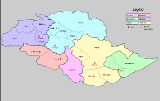
Ghanche District is the easternmost district of Gilgit-Baltistan, Pakistan
. To its northeast is Xinjiang
(China
), to the north and northwest is Skardu District
, to its west is Astore District
and to its south is Ladakh District in the Indian state of Jammu and Kashmir
. The Actual Ground Position Line
(AGPL) at the eastern most part of Ghanche District cuts through the Siachen Glacier
region. Territory east of the AGPL is currently controlled by India
. (It has been proposed by moderates in Pakistan and India to make the Siachen Glacier
region a Peace Park).
The capital of Ghanche District is Khaplu
. This region is the coldest place within Pakistan also called the "Third Pole" with temperatures reaching below -20 °C in the winter. Khaplu Valley
and Hushe Valley
form the gateway for the great Baltoro Muztagh
, the subrange of Karakoram
that includes the mighty peaks of K2
(8,611 m), Broad Peak
(8,047 m), Gasherbrums (8,000+ m) and Masherbrum
(7,821 m) (all of which are included in the Skardu District
).
Pakistan
Pakistan , officially the Islamic Republic of Pakistan is a sovereign state in South Asia. It has a coastline along the Arabian Sea and the Gulf of Oman in the south and is bordered by Afghanistan and Iran in the west, India in the east and China in the far northeast. In the north, Tajikistan...
. To its northeast is Xinjiang
Xinjiang
Xinjiang is an autonomous region of the People's Republic of China. It is the largest Chinese administrative division and spans over 1.6 million km2...
(China
China
Chinese civilization may refer to:* China for more general discussion of the country.* Chinese culture* Greater China, the transnational community of ethnic Chinese.* History of China* Sinosphere, the area historically affected by Chinese culture...
), to the north and northwest is Skardu District
Skardu District
Skardu District is part of Baltistan and currently constitutes one of the seven districts of the Gilgit-Baltistan territory of Pakistan...
, to its west is Astore District
Astore District
Astore is one of the six districts of the Gilgit Baltistan. The district contains the Astore Valley and is bounded to the west by Diamer District , to the north by Gilgit District, to the east by Skardu District and to the south by Khyber-Pakhtunkhwa and Neelum District of Azad Kashmir...
and to its south is Ladakh District in the Indian state of Jammu and Kashmir
Jammu and Kashmir
Jammu and Kashmir is the northernmost state of India. It is situated mostly in the Himalayan mountains. Jammu and Kashmir shares a border with the states of Himachal Pradesh and Punjab to the south and internationally with the People's Republic of China to the north and east and the...
. The Actual Ground Position Line
Actual Ground Position Line
The Actual Ground Position Line refers to the current position that divides Indian and Pakistani troops at the Siachen Glacier. The line extends from the northernmost point of the LOC to Indira Col.-History:...
(AGPL) at the eastern most part of Ghanche District cuts through the Siachen Glacier
Siachen Glacier
The Siachen Glacier is located in the eastern Karakoram range in the Himalaya Mountains at about , just east of the Line of Control between India-Pakistan. India controls all of the Siachen Glacier itself, including all tributary glaciers. At long, it is the longest glacier in the Karakoram and...
region. Territory east of the AGPL is currently controlled by India
India
India , officially the Republic of India , is a country in South Asia. It is the seventh-largest country by geographical area, the second-most populous country with over 1.2 billion people, and the most populous democracy in the world...
. (It has been proposed by moderates in Pakistan and India to make the Siachen Glacier
Siachen Glacier
The Siachen Glacier is located in the eastern Karakoram range in the Himalaya Mountains at about , just east of the Line of Control between India-Pakistan. India controls all of the Siachen Glacier itself, including all tributary glaciers. At long, it is the longest glacier in the Karakoram and...
region a Peace Park).
The capital of Ghanche District is Khaplu
Khaplu
Khaplu is the capital town of the Ghangche District of Gilgit-Baltistan. Lying east of Skardu town, it was the second-largest kingdom in old Baltistan. It guarded the trade route to Ladakh along the Shyok River...
. This region is the coldest place within Pakistan also called the "Third Pole" with temperatures reaching below -20 °C in the winter. Khaplu Valley
Khaplu
Khaplu is the capital town of the Ghangche District of Gilgit-Baltistan. Lying east of Skardu town, it was the second-largest kingdom in old Baltistan. It guarded the trade route to Ladakh along the Shyok River...
and Hushe Valley
Hushe
Hushe is the last village of the Ghangche District of northern Pakistan. It is the highest village in the once extremely remote and impoverished valley. Hushe men began working as cooks and porters for expeditions in the 1960s. Reinhold Messner's cook Rozi Ali, is from Hushe...
form the gateway for the great Baltoro Muztagh
Baltoro Muztagh
The Baltoro Muztagh is a subrange of the Karakoram mountain range, in Baltistan region of the Gilgit-Baltistan province in northern Pakistan; and in Xinjiang, China. The crest of the range forms part of the Pakistan-China border....
, the subrange of Karakoram
Karakoram
The Karakoram, or Karakorum , is a large mountain range spanning the borders between Pakistan, India and China, located in the regions of Gilgit-Baltistan , Ladakh , and Xinjiang region,...
that includes the mighty peaks of K2
K2
K2 is the second-highest mountain on Earth, after Mount Everest...
(8,611 m), Broad Peak
Broad Peak
Broad Peak , is the 12th highest mountain on Earth, with an elevation of 8,051 meters . The literal translation of "Broad Peak" to Faichan Kangri is not accepted among the Balti people.- Geography :...
(8,047 m), Gasherbrums (8,000+ m) and Masherbrum
Masherbrum
Masherbrum is located in the Gilgit Baltistan of Pakistan. At it is the 22nd highest mountain in the world and the 9th highest in Pakistan. It was the first scaled and mapped peak in the Karakoram mountain range, hence its name....
(7,821 m) (all of which are included in the Skardu District
Skardu District
Skardu District is part of Baltistan and currently constitutes one of the seven districts of the Gilgit-Baltistan territory of Pakistan...
).