
Astore District
Encyclopedia
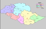
Astore is one of the six districts
of the Gilgit Baltistan. The district contains the Astore Valley
and is bounded to the west by Diamer District
(from which is was separated in 2004), to the north by Gilgit District
, to the east by Skardu District
and to the south by Khyber-Pakhtunkhwa and Neelum District
of Azad Kashmir
. According to the 1998 census of Pakistan the population was 71,666.
FINAH'(RONEI SHANI)
'
(also known as Tshina). Urdu
, which is the National language of Pakistan, is the second most frequently spoken language.There are different dialect of Shina spoken in the region. Since Astore has a history of modest tourist traffic in the summer months, local guides and police in Tarashing or Astore may speak some English.
and Islamabad
through the Karakorum Highway. Landslides and rockfall may be an issue in some areas of the Indus Valley. There is a permanent road through Gilgit as well as seasonal road access via Deosai Plateau to Skardu
. Here you can obtain all types of vehicles (Jeeps, taxis, wagons, SUVs) and hire jeeps and SUVs at affordable prices. The most used vehicles are Jeeps and SUVs with a local preference for Pajeros and Landcruisers.
, the 9th highest peak in the world. To the south of the Nanga Parbat
massif lies Rama Valley, which is home to Rama Lake
, with basic facilities for visitors. It has a hotel called the PTDC, constructed by the government of Pakistan. Astore valley is a unique area for tourists to visit, surrounded by the high peaks of the far western Himalaya. Nearby the two river junction the village Louze, popular for apples,apricot, cherry and other fruits especially the wild almond oil. Louze a small village with literacy rate of about 95%, the only biggest power house for electricity supply up to 1000 kW to whole district approx since 1987, nearby Louze a peaks include Nanga Parbat
, Shaigiri
, Rupal Peak
, Chongra Peak
and Laila Peak (Rupal Valley)
. Astore Valley ascends from the Indus River
Valley near Jaglot, Pakistan
.
Deosai plains are the highest plateau in himalayas and are most picturesque with a bowl shapped lake ,wild flowers,and a habitat of brown bear.The easiest route from Astore
is via, Gorikot
, Gudai
,Chilum and then a track leads to this area with little steep hike.Its been declared a Natural park ,a special status to preserve its fora and fauna.
Districts of Pakistan
The Districts of Pakistan are the second order administrative divisions of Pakistan. Districts were the third order of administrative divisions, below provinces and "divisions", until the reforms of August 2000, when "divisions" were abolished...
of the Gilgit Baltistan. The district contains the Astore Valley
Astore Valley
Astore Valley is now located in Astore District in the autonomous Pakistani regions of Gilgit-Baltistan,previously in the princely state of Jammu and Kashmir. The valley, adjoining the eastern side of mountain Nanga Parbat, is about long, having area of .The entrance of the valley is located...
and is bounded to the west by Diamer District
Diamer District
Diamer District is one of the seven districts of the Northern Areas of Pakistan. It is the district in which the Karakoram Highway enters that territory from the North-West Frontier Province, the capital of the district is Chilas...
(from which is was separated in 2004), to the north by Gilgit District
Gilgit District
Gilgit District is one of the districts of the federal territory of Gilgit-Baltistan in northern Pakistan. It was formed in 1970 when Gilgit-Baltistan was federally administered as the "Northern Areas". It is bounded by the Wakhan Corridor to the north; Xinjiang to the northeast and east; Skardu,...
, to the east by Skardu District
Skardu District
Skardu District is part of Baltistan and currently constitutes one of the seven districts of the Gilgit-Baltistan territory of Pakistan...
and to the south by Khyber-Pakhtunkhwa and Neelum District
Neelum District
Neelum District is one of the eight districts of Azad Jammu and Kashmir, Pakistan. Until recently it was part of Muzaffarabad District. It is bound by the Gilgit to the North, with Kupwara, Baramulla and Bandipore Districts of Indian-administered Kashmir in India to the South and Southeast,...
of Azad Kashmir
Azad Kashmir
Azad Jammu and Kashmir or Azad Kashmir for short, is the southernmost political entity within the Pakistani-administered part of the former princely state of Jammu and Kashmir...
. According to the 1998 census of Pakistan the population was 71,666.
The valley
The Astore vally is located at 35° 2'20.30"N , 75° 6'36.91"E and has an area of 5,092 km² and an altitude of 2600m.Accessibility
Astore is connected to Gilgit which is well connected by air with Islamabad(weather dependent) and by road with Islamabad/Rawalpindi, Skardu and Chitral. You can take a flight to Gilgit from the capital of the country and drive to Astore from Gilgit on metalled road.History
According to the Imperial Gazetteer of India, around 1600:Sub Divisions
- DEOSAI
- BunjiBunji (Pakistan)Bunji or Boanzhe is a small town of Astore District, Northern Areas, Pakistan Administered Kashmir. The distance from Bunji to Gilgit is about 50 km on the Karakoram Highway. Bunji is located at 35°39'N , 74°36'E...
- ChoungrahChoungrahChoungrah is one of the most famous village of Astore District in the Northern Areas of Pakistan. The village contains three sub Villages: Bari Dar, Majini Dar and Thokay dar and is bounded to the east by Khachik and Harcho to the north by Astore Bazar, to the west by Eid Ghah and to the south by...
- LouzeLouzeLouze is a commune in the Haute-Marne department in north-eastern France....
- Louze
- ChilmChilmChilm is a village of Astore District in the Northern Areas of Pakistan. It is located at 35°2'60N 75°7'0E at an altitude of 3869m . It is commonly known as the village of the Mirmat Family, recently migrated to Hajigam, Skardu, Baltistan....
- DashkinDashkinDashkin is a village in the district Astore, 85 km from Gilgit, capital of the Northern Areas of Pakistan.Dashkin is famous for certain rare species of wildlife, such as the Astor Markhor and the Snow Leopard. The people of Dashkin are good at typical traditional sports like swimming, riding,...
- DouanDouanDouan, also known as Doyian, is a small village in the Astore district of Northern Pakistan.It is at the base of the Himalayas. The road to the village famously has 17 uphill turns.The village is divided into Ajjay Douan and Khariyee Douan districts....
- EidghahEidghahEidghah is the 2nd largest Valley and hearquarter of Astore District of Northern Areas of Pakistan, now home to most District government offices....
FINAH'(RONEI SHANI)
'
- GorikotGorikotGorikot is the largest valley in the Astore District of Northern Areas of Pakistan, now home to most district government offices. The local name for the town is Gué...
- GudaiGudaiGudai is a village in the Astore District, Pakistan. It is situated near the villages Khuma, Karbay, Bomray and Booban. The nearest village is Shekong....
- Khuma
- Shekong
- Biyan
- Fateri cani
- okar poro one of the most popular family of shekong.for more information, contact person Nadir shah.
- Gurais
- Minimarg
- Mirmalik
- PakoraPakoraPakora is a fried snack found across South Asia. Pakoras are created by taking one or two ingredients such as onion, eggplant, potato, spinach, plantain, cauliflower, tomato, chilli, or occasionally bread or chicken and dipping them in a batter of gram flour and then deep-frying them...
- ParishingParishingParishing is a small village home of Amanullah Khan of Kashmir Front. It lies South of Astore, northern areas, Gilgit, Pakistan. Parishing means the farthest mountain range....
- Theing Paeen and Bala
- Qamri
- Rahman Pur
- RamaRamaRama or full name Ramachandra is considered to be the seventh avatar of Vishnu in Hinduism, and a king of Ayodhya in ancient Indian...
- RattuRattuRattu is a small town located at the Astore district at the Northern Areas of Pakistan. Rattu was traditionally used as a route for traders going to Kashmir from Astore, Gilgit and others parts of present day Northern Areas of Pakistan...
- Tarishing
- Zian
- Zilla Bala
- Nasir Abad (Qamri)
- Nasir Abad (Zilla Bala)
- Thieng
Climate
Astore valley has a moderate climate during summer. In winter it can snow up to 6 inches (15 cm) in the main valleys and up to 2–3 feet (60–90 cm) in the mountains. In Mirmalik valley it snows up to 6 feet (1.8 m) in February.Languages
The main language spoken in the valley is ShinaShina language
Shina is a Dardic language spoken by a plurality of people in Gilgit-Baltistan of Pakistan and Dras in Ladakh of Indian-Administered Kashmir. The valleys in which it is spoken include Astore, Chilas, Dareil, Tangeer, Gilgit, Ghizer, and a few parts of Baltistan and Kohistan. It is also spoken in...
(also known as Tshina). Urdu
Urdu
Urdu is a register of the Hindustani language that is identified with Muslims in South Asia. It belongs to the Indo-European family. Urdu is the national language and lingua franca of Pakistan. It is also widely spoken in some regions of India, where it is one of the 22 scheduled languages and an...
, which is the National language of Pakistan, is the second most frequently spoken language.There are different dialect of Shina spoken in the region. Since Astore has a history of modest tourist traffic in the summer months, local guides and police in Tarashing or Astore may speak some English.
Transport
There were some negative perceptions in past due to rough mode of transport but nowadays there are paved roads connecting GilgitGilgit
Gilgit is a city in northern PakistanGilgit may refer to other terms related with the area of the city:* Gilgit River* Gilgit Valley* Gilgit District* Gilgit Agency * Gilgit Airport...
and Islamabad
Islamabad
Islamabad is the capital of Pakistan and the tenth largest city in the country. Located within the Islamabad Capital Territory , the population of the city has grown from 100,000 in 1951 to 1.7 million in 2011...
through the Karakorum Highway. Landslides and rockfall may be an issue in some areas of the Indus Valley. There is a permanent road through Gilgit as well as seasonal road access via Deosai Plateau to Skardu
Skardu
Skardu , is the main town of the region Baltistan and the capital of Skardu District, one of the districts making up Pakistan's Gilgit Baltistan....
. Here you can obtain all types of vehicles (Jeeps, taxis, wagons, SUVs) and hire jeeps and SUVs at affordable prices. The most used vehicles are Jeeps and SUVs with a local preference for Pajeros and Landcruisers.
Places of interest
Astore lies about the massive base of Nanga ParbatNanga Parbat
Nanga Parbat is the ninth highest mountain on Earth, the second highest mountain in Pakistan and among the eight-thousanders with a summit elevation of 8,126 meters...
, the 9th highest peak in the world. To the south of the Nanga Parbat
Nanga Parbat
Nanga Parbat is the ninth highest mountain on Earth, the second highest mountain in Pakistan and among the eight-thousanders with a summit elevation of 8,126 meters...
massif lies Rama Valley, which is home to Rama Lake
Rama Lake (Pakistan)
Rama Lake is a lake near Astore in Gilgit-Baltistan, Pakistan. It is on the top of the beautiful Astore Valley, covered with oak trees and greenery.- Location :...
, with basic facilities for visitors. It has a hotel called the PTDC, constructed by the government of Pakistan. Astore valley is a unique area for tourists to visit, surrounded by the high peaks of the far western Himalaya. Nearby the two river junction the village Louze, popular for apples,apricot, cherry and other fruits especially the wild almond oil. Louze a small village with literacy rate of about 95%, the only biggest power house for electricity supply up to 1000 kW to whole district approx since 1987, nearby Louze a peaks include Nanga Parbat
Nanga Parbat
Nanga Parbat is the ninth highest mountain on Earth, the second highest mountain in Pakistan and among the eight-thousanders with a summit elevation of 8,126 meters...
, Shaigiri
Shaigiri
Shaigiri is a lofty mountain in Pakistan's western Himalaya. The peak rises precipitously from the south end of the Rupal Valley, soaring above sea level and some 6,500 feet above the valley floor. To its east stands Rupal Peak, to its west, the iceflows of Rupal Glacier...
, Rupal Peak
Rupal Peak
Rupal Peak is a lofty mountain in Pakistan's western Himalaya. The peak is located just south of Nanga Parbat on the Rupal Valley and is sometimes climbed by mountaineers as they acclimatize for higher local peaks. Despite its unique beauty, steep north face and impressive height, Rupal is greatly...
, Chongra Peak
Chongra Peak
Chongra Peak is a peak in the Himalaya range of the Northern Areas of Pakistan.It is one of the many subsidiary summits of the Nanga Parbat massif.The peak lies just south of the Indus River, in the Northern Areas of Pakistan...
and Laila Peak (Rupal Valley)
Laila Peak (Rupal Valley)
Laila Peak is a major prominence at the southwestern terminus of the Rupal Valley. The peak soars above sea level and some 7,500 feet above the Rupal Valley floor. To its north lies the Rupal Glacier and to its east lies 5,642m Rupal Peak. To the north of the Rupal Glacier stands the Nanga Parbat...
. Astore Valley ascends from the Indus River
Indus River
The Indus River is a major river which flows through Pakistan. It also has courses through China and India.Originating in the Tibetan plateau of western China in the vicinity of Lake Mansarovar in Tibet Autonomous Region, the river runs a course through the Ladakh district of Jammu and Kashmir and...
Valley near Jaglot, Pakistan
Pakistan
Pakistan , officially the Islamic Republic of Pakistan is a sovereign state in South Asia. It has a coastline along the Arabian Sea and the Gulf of Oman in the south and is bordered by Afghanistan and Iran in the west, India in the east and China in the far northeast. In the north, Tajikistan...
.
Deosai plains are the highest plateau in himalayas and are most picturesque with a bowl shapped lake ,wild flowers,and a habitat of brown bear.The easiest route from Astore
Astore
Astore may refer to:*Astore District*Astore River*Astore Valley*Astore, Pakistan*Astore Sports, a sports brand...
is via, Gorikot
Gorikot
Gorikot is the largest valley in the Astore District of Northern Areas of Pakistan, now home to most district government offices. The local name for the town is Gué...
, Gudai
Gudai
Gudai is a village in the Astore District, Pakistan. It is situated near the villages Khuma, Karbay, Bomray and Booban. The nearest village is Shekong....
,Chilum and then a track leads to this area with little steep hike.Its been declared a Natural park ,a special status to preserve its fora and fauna.